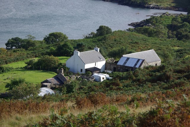
Port nan Athlaich

Sea, Estuary, Creek in Argyllshire

Scotland

Port nan Athlaich

Path to the old jetty at Craignish
Path to the old jetty at Craignish Credit: Alpin Stewart

Port nan Athlaich is a picturesque coastal settlement located in Argyllshire, Scotland. Situated on the western coast of the country, it is nestled between the stunning hills and the vast expanse of the Atlantic Ocean. The name "Port nan Athlaich" translates to "Port of the Gulf" in the Gaelic language, which aptly describes its location at the mouth of a beautiful estuary.

The area boasts breathtaking natural beauty, with its dramatic cliffs, sandy beaches, and crystal-clear waters. The estuary itself is a striking feature, with its calm and sheltered waters providing a safe haven for boats and yachts. This makes Port nan Athlaich a popular destination for boating enthusiasts and those seeking tranquility by the sea.

The village itself is small but charming, with traditional Scottish cottages and buildings lining the narrow streets. The locals are known for their warm hospitality, and visitors can often find cozy bed and breakfasts or guesthouses to stay in while exploring the area.

The surrounding landscape offers ample opportunities for outdoor activities such as hiking, birdwatching, and fishing. The area is rich in wildlife, with seabirds, seals, and even dolphins frequently spotted in the estuary. The nearby hills and moorlands also provide a chance to explore the rugged Scottish countryside.

Overall, Port nan Athlaich is a hidden gem in Argyllshire, offering a perfect blend of natural beauty and tranquility for those seeking a peaceful coastal getaway.

If you have any feedback on the listing, please let us know in the comments section below.

Port nan Athlaich Images

Images are sourced within 2km of 56.138884/-5.6082996 or Grid Reference NR7599. Thanks to Geograph Open Source API. All images are credited.

Path to the old jetty at Craignish
Sròn an Droma Sròn an Droma is the prominent headland at the entrance to Loch Beag. Craignish Castle can be seen in the distance.
Sròn an Droma
Sròn an Droma is the prominent headland at the entrance to Loch Beag. Craignish Castle can be seen in the distance.
Old jetty and ruined building Aird Jetty is at the end of the track beyond the end of the B8002.
Old jetty and ruined building
Aird Jetty is at the end of the track beyond the end of the B8002.
Aird Jetty It's unlikely anyone has used this jetty for a long time.
Aird Jetty
It's unlikely anyone has used this jetty for a long time.
Rocks beside Aird Pier Exposure of Craignish Phyllite beside the pier.
Rocks beside Aird Pier
Exposure of Craignish Phyllite beside the pier.
Aird Jetty Looking towards the old ruined building beside the jetty.
Aird Jetty
Looking towards the old ruined building beside the jetty.
Old ruined building beside Aird Jetty The walls are still in good condition. It just lacks roof, door and windows.
Old ruined building beside Aird Jetty
The walls are still in good condition. It just lacks roof, door and windows.
The B8002 Beside the head of Loch Beag, opposite Craignish Castle.
The B8002
Beside the head of Loch Beag, opposite Craignish Castle.
Disused pier and office at Aird Curiously, very little information exists about these structures on the Craignish peninsula.  The building is noted by several sources as being a 'ticket office' or simply 'office'.  Late 19th century maps show a jetty about one kilometre north as serving a ferry to Jura, but again, little information exists about this.

Scarba looms large in the distance.
Disused pier and office at Aird
Curiously, very little information exists about these structures on the Craignish peninsula. The building is noted by several sources as being a 'ticket office' or simply 'office'. Late 19th century maps show a jetty about one kilometre north as serving a ferry to Jura, but again, little information exists about this. Scarba looms large in the distance.
Aird Jetty
Aird Jetty
The mouth of Loch Beag Craignish Castle on the far right
The mouth of Loch Beag
Craignish Castle on the far right
Old jetty and pier office at Craignish
Stac na h-Iolaire Stac na h-Iolaire, or the Stack of the Eagle, seen in the evening light.
Stac na h-Iolaire
Stac na h-Iolaire, or the Stack of the Eagle, seen in the evening light.
A fishing boat heading home through the Dorus Mòr
Trig pillar on Druim Beithe Paps of Jura in the far distance
Trig pillar on Druim Beithe
Paps of Jura in the far distance
Coastline at Craignish Pier Looking south west along this rocky shoreline with the Paps of Jura in the distance.
Coastline at Craignish Pier
Looking south west along this rocky shoreline with the Paps of Jura in the distance.
Rocks on the Argyll coast Steeply dipping Dalradian rocks on the Argyll coast at Craignish.
Rocks on the Argyll coast
Steeply dipping Dalradian rocks on the Argyll coast at Craignish.
Show me another place!

Port nan Athlaich is located at Grid Ref: NR7599 (Lat: 56.138884, Lng: -5.6082996)

Unitary Authority: Argyll and Bute

Police Authority: Argyll and West Dunbartonshire

What 3 Words

///everyone.workroom.pencil. Near Lochgilphead, Argyll & Bute

Related Wikis

Craignish Castle

Craignish Castle is located on the Craignish peninsula in Argyll, western Scotland and is a category B listed building. The present castle includes a 16th...

Island Macaskin

Island Macaskin or MacAskin (Scottish Gaelic: Eilean MhicAsgain) is an island in Loch Craignish, in the Inner Hebrides of Scotland. It is owned by the...

Loch Craignish

Loch Craignish is a sea loch on the mid-Argyll coast. == Geography == Loch Craignish lies between Oban and the Crinan Canal. Its opens into the Sound of...

Eilean Rìgh

Eilean Rìgh is an island in the Inner Hebrides of the west coast of Scotland. It lies in Loch Craignish, about 300 metres (1⁄8 mile) off the Argyll coastline...

Ardifuir

Ardifuir is a village in Argyll and Bute, Scotland.

Duntrune Castle

Duntrune Castle is located on the north side of Loch Crinan and across from the village of Crinan in Argyll, Scotland. It is thought to be the oldest continuously...

Kinuachdrachd

Kinuachdrachd or Kinuachdrach is a place about 22 miles from Craighouse on the island of Jura, in the council area of Argyll and Bute, Scotland. It comprises...

Eilean Mhic Chrion

Eilean Mhic Chrion is a tidal island sheltering Ardfern in Loch Craignish, Scotland. Eilean Mhic Chrion is one of 43 tidal islands that can be walked to...

Nearby Amenities

Located within 500m of 56.138884,-5.6082996
Source: PGS
Lat/Long: 56.1385209/-5.6082716
Source: PGS
Lat/Long: 56.1386684/-5.6085436
Source: PGS
Lat/Long: 56.1385454/-5.608778
Source: PGS
Lat/Long: 56.1367045/-5.609547
Source: PGS
Lat/Long: 56.1358327/-5.6102326
Source: PGS
Lat/Long: 56.1353297/-5.6107433
Source: PGS
Lat/Long: 56.1349041/-5.6114573
Source: PGS
Lat/Long: 56.1393771/-5.6077701
Source: PGS
Lat/Long: 56.1379031/-5.608697
Source: PGS
Lat/Long: 56.1375444/-5.6088336
Source: PGS
Lat/Long: 56.13638/-5.6098045
Source: PGS
Lat/Long: 56.1352293/-5.6110761
Druim Beithe
Corbett: no
Ele: 60
Graham: no
Marilyn: no
Munro: no
Natural: peak
Lat/Long: 56.1366498/-5.6014836
The data included in this document is from www.openstreetmap.org. The data is made available under ODbL.

Have you been to Port nan Athlaich?

Leave your review of Port nan Athlaich below (or comments, questions and feedback).