Loch Buie

Sea, Estuary, Creek in Argyllshire

Scotland

Loch Buie

Track to Glenbyre West of the area dedicated by Loch Buie community for use by camper vans, the track becomes a little rougher as it heads towards the old farm of Glenbyre. It is still used by vehicles that far, though not for the public. At Rubha na h-Airde Glaise, it sticks close to the cliffs with their wave-cut notch and is surrounded on both sides by Flag Iris. The track is guarded by signs requiring dogs to be on leads at all times, "no excuses", as there are sheep with lambs and ample evidence that they occasionally manage to fall over crags to their deaths (one or two looked likely to be goats who are usually more skilled on rocks, but gravity affects everyone...) Signs also warn of adders which do indeed seem to be quite common on this stretch of the south coast of Mull.
Track to Glenbyre Credit: Andy Waddington

Loch Buie is a picturesque coastal village located in the region of Argyllshire, Scotland. Situated on the eastern coast of the Isle of Mull, it is nestled between the villages of Kinlochspelve and Tiroran. Loch Buie is known for its stunning natural beauty, offering visitors a mix of sea, estuary, and creek landscapes.

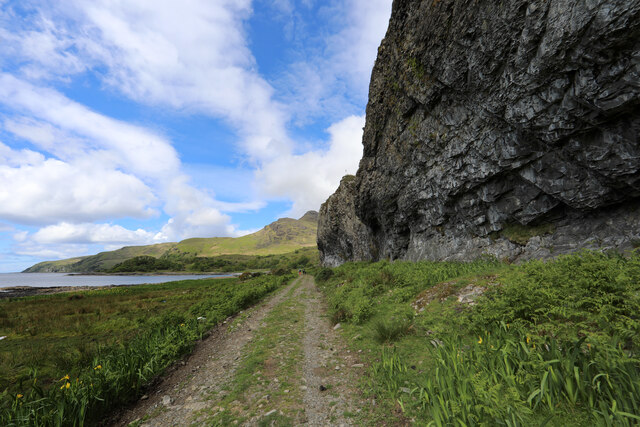
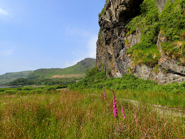
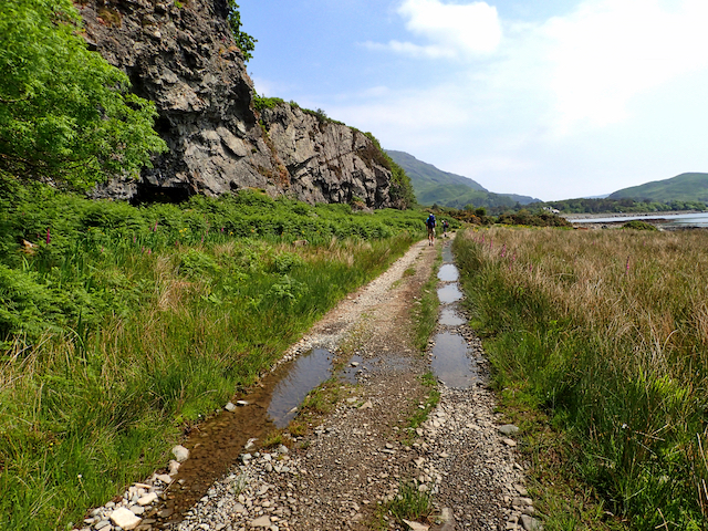
The main attraction of Loch Buie is its eponymous loch, which stretches inland from the coast and merges with the sea at its southernmost point. The loch serves as a tidal estuary, allowing for a rich and diverse ecosystem to flourish. Visitors can explore the loch's expansive shores, which are lined with sandy beaches, rugged cliffs, and rocky outcrops. The crystal-clear waters of the loch are home to a variety of marine life, making it a popular spot for fishing and wildlife enthusiasts.

In addition to the loch, Loch Buie is also characterized by its charming creek, which winds its way through the village and out to the sea. The creek provides a tranquil setting, with its calm waters reflecting the surrounding hills and forests. It serves as a haven for birdwatchers, as numerous species of seabirds can be spotted along its banks.

The village of Loch Buie itself is small and welcoming, with traditional stone cottages scattered throughout. It offers a peaceful retreat for those seeking a break from the hustle and bustle of city life. Visitors can immerse themselves in the local culture by visiting the village's historic church and enjoying a meal at one of the quaint local pubs.

Overall, Loch Buie in Argyllshire is a hidden gem, offering a blend of stunning coastal scenery, diverse wildlife, and a tranquil atmosphere. It is a must-visit destination for nature lovers and those yearning for a peaceful seaside getaway.

If you have any feedback on the listing, please let us know in the comments section below.

Loch Buie Images

Images are sourced within 2km of 56.338199/-5.8882649 or Grid Reference NM5922. Thanks to Geograph Open Source API. All images are credited.

Track to Glenbyre West of the area dedicated by Loch Buie community for use by camper vans, the track becomes a little rougher as it heads towards the old farm of Glenbyre. It is still used by vehicles that far, though not for the public. At Rubha na h-Airde Glaise, it sticks close to the cliffs with their wave-cut notch and is surrounded on both sides by Flag Iris. The track is guarded by signs requiring dogs to be on leads at all times, "no excuses", as there are sheep with lambs and ample evidence that they occasionally manage to fall over crags to their deaths (one or two looked likely to be goats who are usually more skilled on rocks, but gravity affects everyone...) Signs also warn of adders which do indeed seem to be quite common on this stretch of the south coast of Mull.
Track to Glenbyre
West of the area dedicated by Loch Buie community for use by camper vans, the track becomes a little rougher as it heads towards the old farm of Glenbyre. It is still used by vehicles that far, though not for the public. At Rubha na h-Airde Glaise, it sticks close to the cliffs with their wave-cut notch and is surrounded on both sides by Flag Iris. The track is guarded by signs requiring dogs to be on leads at all times, "no excuses", as there are sheep with lambs and ample evidence that they occasionally manage to fall over crags to their deaths (one or two looked likely to be goats who are usually more skilled on rocks, but gravity affects everyone...) Signs also warn of adders which do indeed seem to be quite common on this stretch of the south coast of Mull.
Onward from Tòrr a'Chrabhaiche About one and a half kilometres beyond the public road at Loch Buie, the track to Glenbyre (now a little over halfway there) winds through Flag Iris below wooded slopes southeast of Beinn nan Gobhar. It's about half tide or a little over, precluding any chance of getting into the tiny area of foreshore in the next square to the south - I'll have to come back at low tide in a boat.
Onward from Tòrr a'Chrabhaiche
About one and a half kilometres beyond the public road at Loch Buie, the track to Glenbyre (now a little over halfway there) winds through Flag Iris below wooded slopes southeast of Beinn nan Gobhar. It's about half tide or a little over, precluding any chance of getting into the tiny area of foreshore in the next square to the south - I'll have to come back at low tide in a boat.
Glenbyre Burn meets the beach The Allt nan Fiadh falls steeply in a rocky gorge to pick up numerous equally steep tributaries to form the Glebyre Burn. The gradient eases for the last couple of kilometres to the sea where it spreads onto the beach just west of the old farm of Glebyre and is an easy crossing in dry weather such as this. Although the map shows Stepping Stones, it looks as though it could be a bit challenging in spate.
Glenbyre Burn meets the beach
The Allt nan Fiadh falls steeply in a rocky gorge to pick up numerous equally steep tributaries to form the Glebyre Burn. The gradient eases for the last couple of kilometres to the sea where it spreads onto the beach just west of the old farm of Glebyre and is an easy crossing in dry weather such as this. Although the map shows Stepping Stones, it looks as though it could be a bit challenging in spate.
Rowan at Glenbyre The coast is the haunt not only of sheep, but also feral goats, so a tree is lucky to become tall enough to grow tasty leaves beyond their reach. This Rowan is thus particularly spindly but with a good crop of both flowers and foliage at height. It's curve neatly frames the view to Beinn nan Gobhar.
Rowan at Glenbyre
The coast is the haunt not only of sheep, but also feral goats, so a tree is lucky to become tall enough to grow tasty leaves beyond their reach. This Rowan is thus particularly spindly but with a good crop of both flowers and foliage at height. It's curve neatly frames the view to Beinn nan Gobhar.
Glenbyre Looking across the beach at the outflow of Glenbyre Burn, the old farmhouse of Glenbyre marks the end of the track accessible to vehicles from Loch Buie. Signage indicates environmental work supported financially by the European Union, so that will be a bit out of date now that the perfidious English have voted to drag Scotland out of the EU against the expressed will of its population...
Glenbyre
Looking across the beach at the outflow of Glenbyre Burn, the old farmhouse of Glenbyre marks the end of the track accessible to vehicles from Loch Buie. Signage indicates environmental work supported financially by the European Union, so that will be a bit out of date now that the perfidious English have voted to drag Scotland out of the EU against the expressed will of its population...
Path SW from Glenbyre Beyond the end of the driveable track at Glenbyre, the route from Loch Buie to Carsaig takes a turn to the rough side with both spiny vegetation and scrambly rocks offering some alternative to the boggier stretches underfoot. This is not a bit of path where one can cheerfully apply Naismith's Rule, and we've met various people who have turned back deterred. Being "that sort of parents" I have fond memories of dragging our kids along this stretch a couple of decades ago, amid a certain amount of whinge. At least that time we were only doing it one way...
Path SW from Glenbyre
Beyond the end of the driveable track at Glenbyre, the route from Loch Buie to Carsaig takes a turn to the rough side with both spiny vegetation and scrambly rocks offering some alternative to the boggier stretches underfoot. This is not a bit of path where one can cheerfully apply Naismith's Rule, and we've met various people who have turned back deterred. Being "that sort of parents" I have fond memories of dragging our kids along this stretch a couple of decades ago, amid a certain amount of whinge. At least that time we were only doing it one way...
Ash tree at Glenbyre A solitary Ash tree sits above the reach of the tide (mostly) at the old farm of Glenbyre. Whilst apparently not occupied, the farm is definitely still in use and it looks as though someone has been taking time out to use an old mooring buoy as a swing from one of the lower branches.
Ash tree at Glenbyre
A solitary Ash tree sits above the reach of the tide (mostly) at the old farm of Glenbyre. Whilst apparently not occupied, the farm is definitely still in use and it looks as though someone has been taking time out to use an old mooring buoy as a swing from one of the lower branches.
Crag near Rubha na h-Àirde Glaise An impressive crag overlooking the rocky point. Surprisingly the Ordnance Survey doesn't seem to have given it a name.
Crag near Rubha na h-Àirde Glaise
An impressive crag overlooking the rocky point. Surprisingly the Ordnance Survey doesn't seem to have given it a name.
On Eilean Mòr Looking towards Lochbuie House.
On Eilean Mòr
Looking towards Lochbuie House.
West of Lochbuie Looking west.
West of Lochbuie
Looking west.
Eilean Mòr Looking towards Ben Buie.
Eilean Mòr
Looking towards Ben Buie.
Basalt dyke, below Guala a' Mhairbh Following in the footsteps of David Balfour, the hero of Robert Louis Stevenson's Kidnapped, as he makes his way back to Edinburgh to confront his wicked uncle.

Stage 1, June 2016 from Erraid to Fishnish on the Isle of Mull.

See <span class="nowrap"><a title="http://www.stevensonway.org.uk" rel="nofollow ugc noopener" href="http://www.stevensonway.org.uk">Link</a><img style="margin-left:2px;" alt="External link" title="External link - shift click to open in new window" src="https://s1.geograph.org.uk/img/external.png" width="10" height="10"/></span>
Basalt dyke, below Guala a' Mhairbh
Following in the footsteps of David Balfour, the hero of Robert Louis Stevenson's Kidnapped, as he makes his way back to Edinburgh to confront his wicked uncle. Stage 1, June 2016 from Erraid to Fishnish on the Isle of Mull. See LinkExternal link
Glen Byre Following in the footsteps of David Balfour, the hero of Robert Louis Stevenson's Kidnapped, as he makes his way back to Edinburgh to confront his wicked uncle.

Stage 1, June 2016 from Erraid to Fishnish on the Isle of Mull.

See <span class="nowrap"><a title="http://www.stevensonway.org.uk" rel="nofollow ugc noopener" href="http://www.stevensonway.org.uk">Link</a><img style="margin-left:2px;" alt="External link" title="External link - shift click to open in new window" src="https://s1.geograph.org.uk/img/external.png" width="10" height="10"/></span>
Glen Byre
Following in the footsteps of David Balfour, the hero of Robert Louis Stevenson's Kidnapped, as he makes his way back to Edinburgh to confront his wicked uncle. Stage 1, June 2016 from Erraid to Fishnish on the Isle of Mull. See LinkExternal link
Wooded hillside near Goill' a' Chaiginn Following in the footsteps of David Balfour, the hero of Robert Louis Stevenson's Kidnapped, as he makes his way back to Edinburgh to confront his wicked uncle.

Stage 1, June 2016 from Erraid to Fishnish on the Isle of Mull.

See <span class="nowrap"><a title="http://www.stevensonway.org.uk" rel="nofollow ugc noopener" href="http://www.stevensonway.org.uk">Link</a><img style="margin-left:2px;" alt="External link" title="External link - shift click to open in new window" src="https://s1.geograph.org.uk/img/external.png" width="10" height="10"/></span>
Wooded hillside near Goill' a' Chaiginn
Following in the footsteps of David Balfour, the hero of Robert Louis Stevenson's Kidnapped, as he makes his way back to Edinburgh to confront his wicked uncle. Stage 1, June 2016 from Erraid to Fishnish on the Isle of Mull. See LinkExternal link
Track below Goill' a' Chaiginn Following in the footsteps of David Balfour, the hero of Robert Louis Stevenson's Kidnapped, as he makes his way back to Edinburgh to confront his wicked uncle.

Stage 1, June 2016 from Erraid to Fishnish on the Isle of Mull.

See <span class="nowrap"><a title="http://www.stevensonway.org.uk" rel="nofollow ugc noopener" href="http://www.stevensonway.org.uk">Link</a><img style="margin-left:2px;" alt="External link" title="External link - shift click to open in new window" src="https://s1.geograph.org.uk/img/external.png" width="10" height="10"/></span>
Track below Goill' a' Chaiginn
Following in the footsteps of David Balfour, the hero of Robert Louis Stevenson's Kidnapped, as he makes his way back to Edinburgh to confront his wicked uncle. Stage 1, June 2016 from Erraid to Fishnish on the Isle of Mull. See LinkExternal link
Eilean a' Chràbhaiche Following in the footsteps of David Balfour, the hero of Robert Louis Stevenson's Kidnapped, as he makes his way back to Edinburgh to confront his wicked uncle.

Stage 1, June 2016 from Erraid to Fishnish on the Isle of Mull.

See <span class="nowrap"><a title="http://www.stevensonway.org.uk" rel="nofollow ugc noopener" href="http://www.stevensonway.org.uk">Link</a><img style="margin-left:2px;" alt="External link" title="External link - shift click to open in new window" src="https://s1.geograph.org.uk/img/external.png" width="10" height="10"/></span>
Eilean a' Chràbhaiche
Following in the footsteps of David Balfour, the hero of Robert Louis Stevenson's Kidnapped, as he makes his way back to Edinburgh to confront his wicked uncle. Stage 1, June 2016 from Erraid to Fishnish on the Isle of Mull. See LinkExternal link
Glenbyre, Mull Glenbyre Burn reaches Loch Buie at Glenbyre Farm.
Glenbyre, Mull
Glenbyre Burn reaches Loch Buie at Glenbyre Farm.
Show me another place!

Loch Buie is located at Grid Ref: NM5922 (Lat: 56.338199, Lng: -5.8882649)

Unitary Authority: Argyll and Bute

Police Authority: Argyll and West Dunbartonshire

What 3 Words

///remaking.cactus.finishing. Near Lochbuie, Argyll & Bute

Nearby Locations

Loch Buie

Related Wikis

Loch Buie

Loch Buie (Scottish Gaelic: Locha Buidhe, meaning "yellow loch") is a sea loch on the south coast of the Isle of Mull, off the west coast of Scotland....

Moy Castle

Moy Castle is a ruined castle near Lochbuie on the Isle of Mull, Scotland. The site is now a scheduled monument. == History == The land upon which Moy...

Lochbuie, Mull

Lochbuie (Scottish Gaelic: Locha Buidhe, meaning "yellow loch") is a settlement on the Isle of Mull in Scotland about 22 kilometres (14 mi) west of Craignure...

Ben Buie

Ben Buie (717 m) is a mountain in the south of the Isle of Mull, Scotland. A rocky mountain, it has steep and rugged slopes, especially on its eastern...

Have you been to Loch Buie?

Leave your review of Loch Buie below (or comments, questions and feedback).