Sloc Bà Fetta

Sea, Estuary, Creek in Argyllshire

Scotland

Sloc Bà Fetta

Low springs links Tràigh Mhòr and Eilean Mòr Even at high tide there's some land in this square, but near the bottom of a spring tide, the weed covered rocks are quite extensive and there is no difficulty in being far enough inside the square teo be sure of a point. The low tides, however, mean that the series of cruise ships visiting Iona have been anchoring quite a way south of the jetty, and sending their inmates ashore by long trips on RIBs. There's one there now, but so far south that it is out of shot. This one seems to send them ahsore in identical red waterproofs so that, milling around ashore, they are instantly identifiable as temporary refugees from the prison hulk offshore...
Low springs links Tràigh Mhòr and Eilean Mòr Credit: Andy Waddington

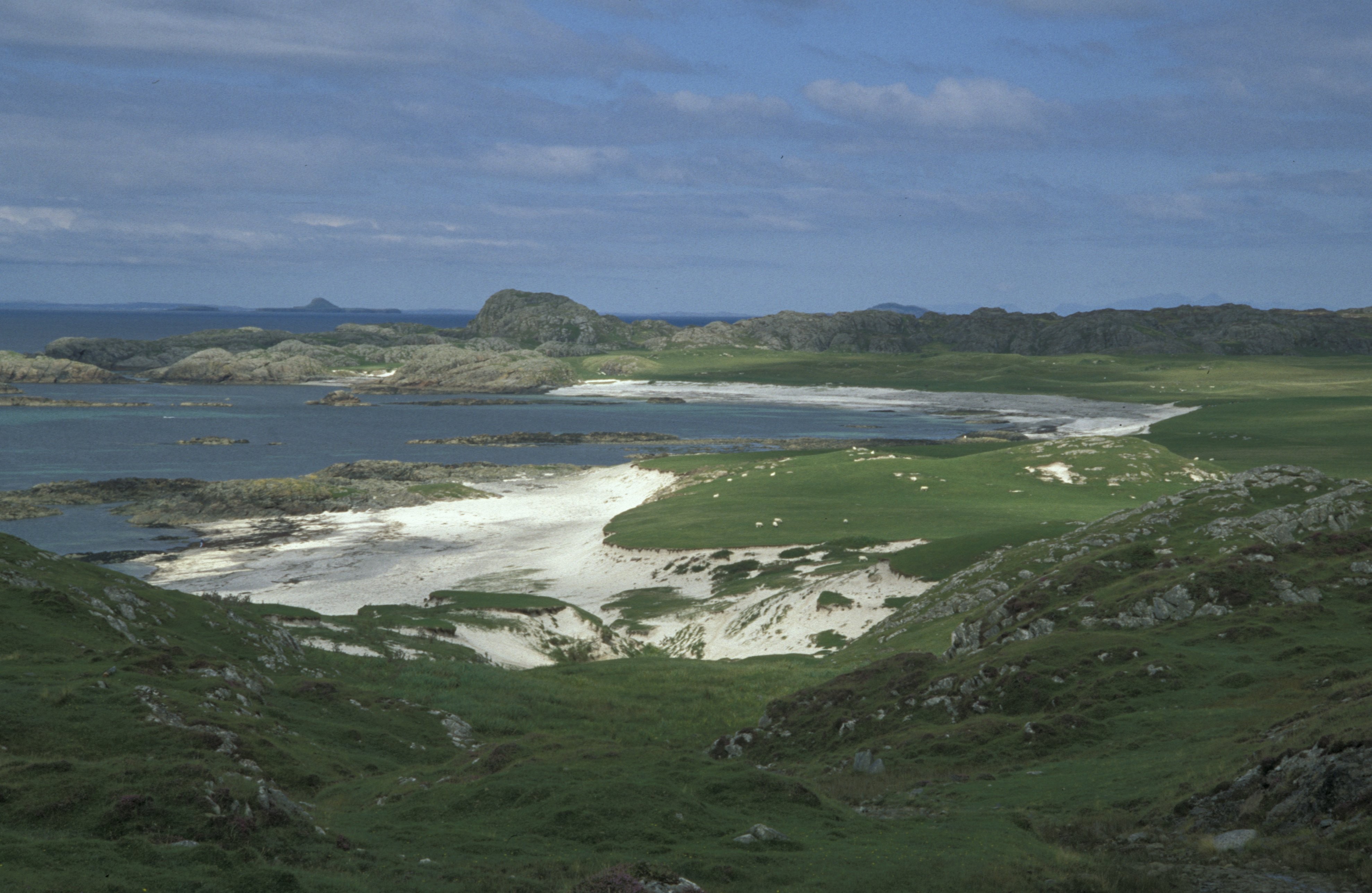
Sloc Bà Fetta, located in Argyllshire, Scotland, is a picturesque coastal area that encompasses a sea, estuary, and creek. Nestled on the western coast of the Scottish Highlands, it is renowned for its breathtaking natural beauty and tranquil atmosphere.

The sea at Sloc Bà Fetta offers stunning vistas of the Atlantic Ocean, with its deep blue waters extending as far as the eye can see. It is a haven for maritime enthusiasts, attracting sailors, yachtsmen, and fishermen alike. The sea provides abundant opportunities for water sports such as surfing, kayaking, and paddleboarding.

The estuary at Sloc Bà Fetta is a unique blend of freshwater and saltwater, where a river meets the sea. This brackish water environment is home to a diverse range of flora and fauna, making it a paradise for nature lovers. Birdwatchers flock to the estuary to observe a variety of species, including herons, wading birds, and migratory birds.

The creek, nestled within the estuary, is a narrow, winding waterway that meanders through dense forests and rolling hills. It offers a serene and secluded setting for those seeking solitude and tranquility. Visitors can explore the creek by kayak or small boat, immersing themselves in the beauty of the surrounding landscape.

Sloc Bà Fetta is a destination that captivates visitors with its natural charm and serenity. Whether you are looking to admire stunning seascapes, explore a diverse estuarine ecosystem, or indulge in peaceful creek-side adventures, this coastal gem in Argyllshire is sure to leave a lasting impression.

If you have any feedback on the listing, please let us know in the comments section below.

Sloc Bà Fetta Images

Images are sourced within 2km of 56.308093/-6.4189506 or Grid Reference NM2621. Thanks to Geograph Open Source API. All images are credited.

Low springs links Tràigh Mhòr and Eilean Mòr Even at high tide there's some land in this square, but near the bottom of a spring tide, the weed covered rocks are quite extensive and there is no difficulty in being far enough inside the square teo be sure of a point. The low tides, however, mean that the series of cruise ships visiting Iona have been anchoring quite a way south of the jetty, and sending their inmates ashore by long trips on RIBs. There's one there now, but so far south that it is out of shot. This one seems to send them ahsore in identical red waterproofs so that, milling around ashore, they are instantly identifiable as temporary refugees from the prison hulk offshore...
Low springs links Tràigh Mhòr and Eilean Mòr
Even at high tide there's some land in this square, but near the bottom of a spring tide, the weed covered rocks are quite extensive and there is no difficulty in being far enough inside the square teo be sure of a point. The low tides, however, mean that the series of cruise ships visiting Iona have been anchoring quite a way south of the jetty, and sending their inmates ashore by long trips on RIBs. There's one there now, but so far south that it is out of shot. This one seems to send them ahsore in identical red waterproofs so that, milling around ashore, they are instantly identifiable as temporary refugees from the prison hulk offshore...
Dropping down to Tràigh Mhòr There's just a tiny fraction of Iona that isn't under the cosh of the National Trust for Scotland, and this is part of it. The result, however, is that it is well fenced off from the NTS domains, which are a little inaccessible to anyone who has visited this corner to get the Tràigh Mhòr bit of land in NM2824. The solution was to return to the beach via this descent and walk all the way back round to the road.
Dropping down to Tràigh Mhòr
There's just a tiny fraction of Iona that isn't under the cosh of the National Trust for Scotland, and this is part of it. The result, however, is that it is well fenced off from the NTS domains, which are a little inaccessible to anyone who has visited this corner to get the Tràigh Mhòr bit of land in NM2824. The solution was to return to the beach via this descent and walk all the way back round to the road.
Cairn at Tràigh Mhòr A small part of Iona free of the National Trust for Scotland, above Tràigh Mhòr this little grassy peninsula south of Sligneach sports a jolly cairn and looks as though it has been used as a picnic spot.
Cairn at Tràigh Mhòr
A small part of Iona free of the National Trust for Scotland, above Tràigh Mhòr this little grassy peninsula south of Sligneach sports a jolly cairn and looks as though it has been used as a picnic spot.
Sound of Iona Looking SSE from Dun I, at 101 metres the highest point on Iona, over the Sound of Iona towards Mull with, in the centre, Iona Abbey and directly above it  the Paps of Jura 35 miles away. The island to the right off Mull is Erraid which features prominently in 'Kidnapped' where David Balfour was wrecked at Traigh Geal and thought himself marooned till he found that a strand on its east coast dries out over low tide and you can walk across to Mull. Stevenson is believed to have written 'Kidnapped' whilst staying at a cottage on the island.
Sound of Iona
Looking SSE from Dun I, at 101 metres the highest point on Iona, over the Sound of Iona towards Mull with, in the centre, Iona Abbey and directly above it the Paps of Jura 35 miles away. The island to the right off Mull is Erraid which features prominently in 'Kidnapped' where David Balfour was wrecked at Traigh Geal and thought himself marooned till he found that a strand on its east coast dries out over low tide and you can walk across to Mull. Stevenson is believed to have written 'Kidnapped' whilst staying at a cottage on the island.
Old Marble Quarry, Iona The old cutting rig and gas engine can be seen in picture.
Old Marble Quarry, Iona
The old cutting rig and gas engine can be seen in picture.
By Steamer To Iona - 4th June 2012 : The Sound Of Iona Having steamed from Oban along the south coast of Mull the paddlesteamer Waverley has entered the shallow waters of the Sound of Iona, which separates the island of Iona (left) from the Ross Of Mull (right).
By Steamer To Iona - 4th June 2012 : The Sound Of Iona
Having steamed from Oban along the south coast of Mull the paddlesteamer Waverley has entered the shallow waters of the Sound of Iona, which separates the island of Iona (left) from the Ross Of Mull (right).
Sithean
Sithean
The centre of Iona View across the middle part of the island from a faint path that heads across the moor from Ruanaich.
The centre of Iona
View across the middle part of the island from a faint path that heads across the moor from Ruanaich.
Some rather nice gneiss Colourful outcrop of Lewisian gneiss at the southern end of Iona. All the higher parts of the island as well as the south and west coasts are made of this ancient rock.
Some rather nice gneiss
Colourful outcrop of Lewisian gneiss at the southern end of Iona. All the higher parts of the island as well as the south and west coasts are made of this ancient rock.
Pebble maze, Port na Curaich Someone has spent a lot of time and effort to create a maze from pebbles at Columba's Bay. The design is similar to those seen in some cathedrals [Chartres?] and may have some religious significance.  Nearby are some large piles of pebbles. It is said that in the past monks from the abbey created stone piles, the height and size relative to the magnitude of their sins. Either they must have sinned for a very long time, or someone has been carrying on the tradition.
Pebble maze, Port na Curaich
Someone has spent a lot of time and effort to create a maze from pebbles at Columba's Bay. The design is similar to those seen in some cathedrals [Chartres?] and may have some religious significance. Nearby are some large piles of pebbles. It is said that in the past monks from the abbey created stone piles, the height and size relative to the magnitude of their sins. Either they must have sinned for a very long time, or someone has been carrying on the tradition.
Port na Curaich [Port of the Coracle] The pebble beach where St Columba is said to have landed at the southern end of Iona.
Port na Curaich [Port of the Coracle]
The pebble beach where St Columba is said to have landed at the southern end of Iona.
Loch Staoineig Small hill loch by the track to Columba's Bay. A late March day in the early afternoon, but ice was still covering the surface of the loch in places.
Loch Staoineig
Small hill loch by the track to Columba's Bay. A late March day in the early afternoon, but ice was still covering the surface of the loch in places.
At the edge of the sands The view from the edge of the machair towards Port Ceann na Creige.
At the edge of the sands
The view from the edge of the machair towards Port Ceann na Creige.
Overlooking Columba's Bay This is said to be St Columbus landed on Iona to establish his ministry.
Overlooking Columba's Bay
This is said to be St Columbus landed on Iona to establish his ministry.
Low Tide at Traigh Mhor A low tide gave good access to this square which is largely sand and rocks.
Low Tide at Traigh Mhor
A low tide gave good access to this square which is largely sand and rocks.
Low Tide at Traigh Mhor A low tide gave good access to this square which is largely sand and rocks.
Low Tide at Traigh Mhor
A low tide gave good access to this square which is largely sand and rocks.
Low Tide at Traigh Mhor A low tide gave good access to this square which is largely sand and rocks.
Low Tide at Traigh Mhor
A low tide gave good access to this square which is largely sand and rocks.
Traigh Mhor The tide reaches right up to the rocky coast.
Traigh Mhor
The tide reaches right up to the rocky coast.
Show me another place!

Sloc Bà Fetta is located at Grid Ref: NM2621 (Lat: 56.308093, Lng: -6.4189506)

Unitary Authority: Argyll and Bute

Police Authority: Argyll and West Dunbartonshire

What 3 Words

///model.twit.overture. Near Fionnphort, Argyll & Bute

Related Wikis

Bay at the Back of the Ocean

The Bay at the Back of the Ocean (Scottish Gaelic: Camas Cuil an t-Saimh) is a wide, west facing bay on the island of Iona, Argyll and Bute, Scotland,...

Iona

Iona (; Scottish Gaelic: Ì Chaluim Chille [ˈiː ˈxal̪ˠɪm ˈçiʎə] , sometimes simply Ì) is a small island in the Inner Hebrides, off the Ross of Mull on the...

Sound of Iona

The Sound of Iona is a sound between the Inner Hebridean islands of Mull and Iona in western Scotland. It forms part of the Atlantic Ocean. The tidal...

Bishop's House, Iona

Bishop's House is a retreat house for the Scottish Episcopal Church, located on the island of Iona, off the west coast of Scotland. == History == It was...

Iona Abbey

Iona Abbey is an abbey located on the island of Iona, just off the Isle of Mull on the West Coast of Scotland. It is one of the oldest Christian religious...

St Oran's Chapel

St Oran's Chapel (Odhráin/Orain/Odran) is a medieval chapel located on the island of Iona in the Inner Hebrides off the west coast of Scotland. Built in...

Erraid

Erraid (Scottish Gaelic: Eilean Earraid) is a tidal island approximately one mile (two kilometres) square located in the Inner Hebrides of Scotland. It...

Fionnphort

Fionnphort (English: , Scottish Gaelic: [ˈfjun̪ˠafɔrˠt̪]) is the principal port of the Ross of Mull, and the second largest settlement in the area (its...

Nearby Amenities

Located within 500m of 56.308093,-6.4189506
Marble Quarry (Dis.)
Historic: archaeological_site
Lat/Long: 56.3100198/-6.4180497
The data included in this document is from www.openstreetmap.org. The data is made available under ODbL.

Have you been to Sloc Bà Fetta?

Leave your review of Sloc Bà Fetta below (or comments, questions and feedback).