Colman's Dyke

Sea, Estuary, Creek in Suffolk East Suffolk

England

Colman's Dyke

Houses in Residential Area of Oulton Broad, Lowestoft, Suffolk This grid square is mainly residential. Most of the housing was built in batches on estates of various ages. The photo shows a typical three bedroom house built in the early 1960s in a chalet bungalow style.
Houses in Residential Area of Oulton Broad, Lowestoft, Suffolk Credit: Pete Chapman

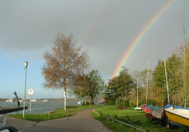
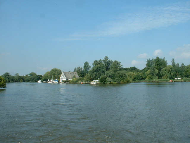
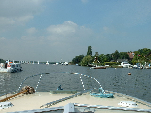
Colman's Dyke is a picturesque waterway located in Suffolk, England. It lies on the eastern coast of the country, near the town of Lowestoft. Spanning over a length of approximately 2 miles, Colman's Dyke is a unique combination of sea, estuary, and creek.

The dyke starts as a narrow creek branching off from the North Sea near Ness Point, the most easterly point of the United Kingdom. As it moves inland, the creek gradually widens, eventually transforming into an estuary. The estuary is surrounded by beautiful marshes and wetlands, creating an important habitat for a variety of bird species, including waders and waterfowl.

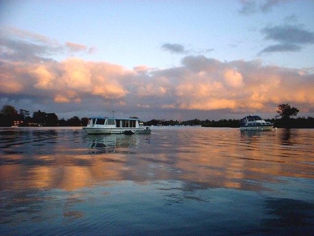
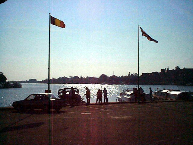
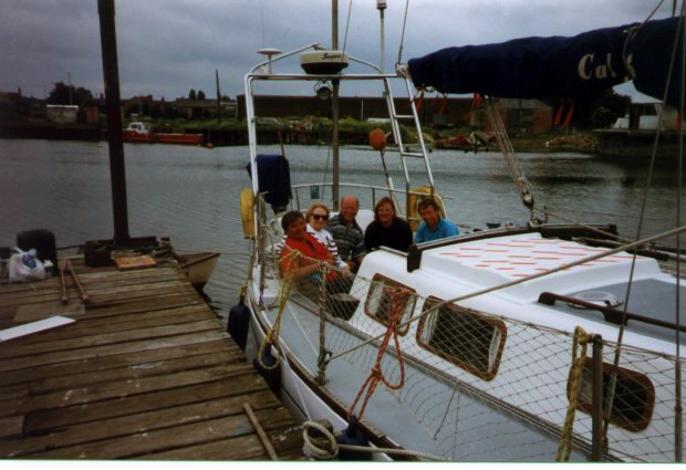
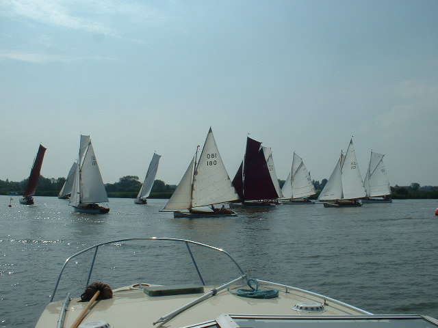
At high tide, the estuary fills with seawater, creating a serene and reflective body of water that is perfect for boating and sailing enthusiasts. At low tide, the water recedes, unveiling expansive mudflats that attract birdwatchers and nature lovers alike.

Colman's Dyke is also home to a diverse range of marine life. The nutrient-rich waters support a thriving ecosystem, with fish, crabs, and other marine creatures populating its depths. The area is a popular spot for anglers, who come to enjoy the tranquility and try their luck at catching the local fish species.

Overall, Colman's Dyke offers a unique blend of natural beauty, biodiversity, and recreational opportunities. Whether it's exploring the creek by boat, observing the diverse birdlife, or simply taking a leisurely stroll along the water's edge, visitors to Colman's Dyke are sure to be captivated by its scenic charm and abundant wildlife.

If you have any feedback on the listing, please let us know in the comments section below.

Colman's Dyke Images

Images are sourced within 2km of 52.472109/1.7059989 or Grid Reference TM5192. Thanks to Geograph Open Source API. All images are credited.

Houses in Residential Area of Oulton Broad, Lowestoft, Suffolk This grid square is mainly residential. Most of the housing was built in batches on estates of various ages. The photo shows a typical three bedroom house built in the early 1960s in a chalet bungalow style.
Houses in Residential Area of Oulton Broad, Lowestoft, Suffolk
This grid square is mainly residential. Most of the housing was built in batches on estates of various ages. The photo shows a typical three bedroom house built in the early 1960s in a chalet bungalow style.
Children's Playground, Nicholas Everitt Park, Oulton Broad, Lowestoft, Suffolk A seesaw in the children's play area at Nicholas Everitt Park. The play area includes swings, seesaw, climbing frames and various slides (including a spiral helter-skelter). There is also a small boating lake. The park is situated on the banks of Oulton Broad and provides a good vantage point for observing waterborne activities.
Children's Playground, Nicholas Everitt Park, Oulton Broad, Lowestoft, Suffolk
A seesaw in the children's play area at Nicholas Everitt Park. The play area includes swings, seesaw, climbing frames and various slides (including a spiral helter-skelter). There is also a small boating lake. The park is situated on the banks of Oulton Broad and provides a good vantage point for observing waterborne activities.
Wherry Hotel and Mutford Lock, Oulton Broad Lowestoft This photo was taken from the end of a nearby jetty into Oulton Broad. The entrance to the lock is near to the blue and red sign and is the southern link with the North Sea for the Norfolk Broads. The road bridge crossing over the top of the lock has been replaced since the photo was taken. The Wherry Hotel has been here for many years and offers good views over the Broad.
Wherry Hotel and Mutford Lock, Oulton Broad Lowestoft
This photo was taken from the end of a nearby jetty into Oulton Broad. The entrance to the lock is near to the blue and red sign and is the southern link with the North Sea for the Norfolk Broads. The road bridge crossing over the top of the lock has been replaced since the photo was taken. The Wherry Hotel has been here for many years and offers good views over the Broad.
Level Crossing, Oulton Marshes, Near Oulton Broad, Lowestoft, Suffolk The Norwich to Lowestoft railway line passes over Oulton Marshes. This level crossing enables a bridleway between St Michael's Church, Oulton and Oulton Dyke to cross the line.
Level Crossing, Oulton Marshes, Near Oulton Broad, Lowestoft, Suffolk
The Norwich to Lowestoft railway line passes over Oulton Marshes. This level crossing enables a bridleway between St Michael's Church, Oulton and Oulton Dyke to cross the line.
North bank of Oulton Broad, Lowestoft, Suffolk View of the N side of the Broad taken from Nicholas Everitt Park (S Side)
North bank of Oulton Broad, Lowestoft, Suffolk
View of the N side of the Broad taken from Nicholas Everitt Park (S Side)
North Shore of Lake Lothing, Outton Broad, Suffolk Lake Lothing is the tidal access (via Mutford Lock at Oulton Broad) of the River Waveney to the North Sea at Lowestoft. The Northern shore at the Oulton Broad end has several small boat building an repair businesses. The right of the picture shows oil storage tanks.
North Shore of Lake Lothing, Outton Broad, Suffolk
Lake Lothing is the tidal access (via Mutford Lock at Oulton Broad) of the River Waveney to the North Sea at Lowestoft. The Northern shore at the Oulton Broad end has several small boat building an repair businesses. The right of the picture shows oil storage tanks.
Residential housing estate, Oulton Broad, Lowestoft, Suffolk Conrad Close is part of an estate of 1960s houses, a mixture of semi-detached bungalows and two storey houses. View taken looking SE towards the rising winter sun.
Residential housing estate, Oulton Broad, Lowestoft, Suffolk
Conrad Close is part of an estate of 1960s houses, a mixture of semi-detached bungalows and two storey houses. View taken looking SE towards the rising winter sun.
Oulton Broad Railway Swing Bridge and Mutford Lock Road Bridge (under Construction) The Railway bridge is in the background (with the red flag flying from it). This new road bridge was built as part of a local bypass to ease traffic flow    through Oulton Broad.
Oulton Broad Railway Swing Bridge and Mutford Lock Road Bridge (under Construction)
The Railway bridge is in the background (with the red flag flying from it). This new road bridge was built as part of a local bypass to ease traffic flow through Oulton Broad.
Sunset on Oulton Broad with cruisers A perfect evening, still and warm with cruisers coming into Oulton Broad from Oulkton Cut.
Sunset on Oulton Broad with cruisers
A perfect evening, still and warm with cruisers coming into Oulton Broad from Oulkton Cut.
Late evening on the Waveney Taken on the way back to Oulton Broad from the Waveney junction
Late evening on the Waveney
Taken on the way back to Oulton Broad from the Waveney junction
Rainbow on Oulton Broad seen from the Public Slipway A crisp November morning, waiting for the rain to stop before we launched.
Rainbow on Oulton Broad seen from the Public Slipway
A crisp November morning, waiting for the rain to stop before we launched.
Lowestoft
Lowestoft
Robbies Boat
Robbies Boat
Entrance to Oulton Broad, from Oulton Dyke
Converted Brewery, Oulton Broad Now [presumably] expensive apartments.
Converted Brewery, Oulton Broad
Now [presumably] expensive apartments.
Oulton Broad This popular Broad has many different types of craft active upon it.
Oulton Broad
This popular Broad has many different types of craft active upon it.
Racing on Oulton Broad I do not recognise the class of yacht, maybe it is a 'local' class?
Racing on Oulton Broad
I do not recognise the class of yacht, maybe it is a 'local' class?
The Wherry Hotel in 2005 Unfortunately I did not cover the same shot as Pete Chapman did, but the Wherry Hotel is still going strong.
The Wherry Hotel in 2005
Unfortunately I did not cover the same shot as Pete Chapman did, but the Wherry Hotel is still going strong.
Show me another place!

Colman's Dyke is located at Grid Ref: TM5192 (Lat: 52.472109, Lng: 1.7059989)

Administrative County: Suffolk

District: East Suffolk

Police Authority: Suffolk

What 3 Words

///tapes.crew.tripods. Near Lowestoft, Suffolk

Related Wikis

Oulton Broad South railway station

Oulton Broad South railway station (originally Carlton Colville) is on the East Suffolk Line in the east of England, and is one of two stations serving...

Oulton Broad

Oulton Broad refers to both the lake and the suburb of Lowestoft in the English county of Suffolk. The suburb is located 2 miles (3.2 km) west of the centre...

South Broads Lifeboat Station

South Broads Lifeboat Station was an RNLI operated lifeboat station located on Oulton Broad in the town of Lowestoft in the English county of Suffolk....

Oulton Broad North railway station

Oulton Broad North railway station (originally opened as Mutford and later known as Oulton Broad (Mutford) and Oulton Broad) is on the Wherry Lines in...

Nearby Amenities

Located within 500m of 52.472109,1.7059989
Traffic Signals
Lat/Long: 52.4688339/1.7069247
Oulton Broad South
Naptan AtcoCode: 9100OULTNBS
Network: National Rail
Network Website: https://www.nationalrail.co.uk/stations/ous/
Network Wikidata: Q26334
Old Name: Carlton Colville
Public Transport: station
Railway: station
Ref Crs: OUS
Wikidata: Q1870239
Wikipedia: en:Oulton Broad South railway station
Lat/Long: 52.4695869/1.7074886
Give Way
Lat/Long: 52.4705114/1.7086355
Bus Stop
Swing Bridge
Bus: yes
Local Ref: NR
Naptan AtcoCode: 390070659
Naptan Bearing: N
Naptan CommonName: Swing Bridge
Naptan Indicator: nr
Naptan Landmark: Swing Bridge
Naptan NaptanCode: sufjatpg
Naptan PlusbusZoneRef: LOWSTFT
Naptan Street: Saltwater Way
Naptan Verified: no
Public Transport: platform
Source: naptan_import
Lat/Long: 52.4731472/1.7103384
Bus Stop
John Lang Court
Bus: yes
Naptan AtcoCode: 390070660
Naptan Bearing: S
Naptan CommonName: John Lang Court
Naptan Indicator: opp
Naptan Landmark: John Lang Court
Naptan NaptanCode: sufjatpj
Naptan PlusbusZoneRef: LOWSTFT
Naptan Street: Bridge Road
Naptan Verified: no
Public Transport: platform
Source: naptan_import
Lat/Long: 52.471464/1.7091873
Bus Stop
John Lang Court
Bus: yes
Local Ref: NR
Naptan AtcoCode: 390070661
Naptan Bearing: N
Naptan CommonName: John Lang Court
Naptan Indicator: nr
Naptan Landmark: John Lang Court
Naptan NaptanCode: sufjatpm
Naptan PlusbusZoneRef: LOWSTFT
Naptan Street: Bridge Road
Naptan Verified: no
Public Transport: platform
Source: naptan_import
Lat/Long: 52.471274/1.7089357
Bus Stop
Flying Dutchman
Bench: no
Bin: no
Bus: yes
Lit: yes
Naptan AtcoCode: 390070663
Naptan Bearing: SW
Naptan CommonName: Flying Dutchman
Naptan Indicator: adj
Naptan Landmark: Flying Dutchman
Naptan NaptanCode: sufjatpw
Naptan PlusbusZoneRef: LOWSTFT
Naptan Street: Beccles Road
Naptan Verified: no
Public Transport: platform
Shelter: no
Source: naptan_import
Tactile Paving: no
Lat/Long: 52.4684309/1.7060894
Bus Stop
Flying Dutchman
Bench: no
Bin: no
Bus: yes
Naptan AtcoCode: 390070664
Naptan Bearing: NE
Naptan CommonName: Flying Dutchman
Naptan Indicator: opp
Naptan Landmark: Flying Dutchman
Naptan NaptanCode: sufjatwa
Naptan PlusbusZoneRef: LOWSTFT
Naptan Street: Beccles Road
Naptan Verified: no
Public Transport: platform
Shelter: yes
Source: naptan_import
Tactile Paving: no
Lat/Long: 52.4683985/1.705689
Bus Stop
Dixon Drive
Bus: yes
Naptan AtcoCode: 390070741
Naptan Bearing: E
Naptan CommonName: Dixon Drive
Naptan Indicator: adj
Naptan Landmark: Dixon Drive
Naptan NaptanCode: sufjdama
Naptan PlusbusZoneRef: LOWSTFT
Naptan Street: Dell Road
Naptan Verified: no
Public Transport: platform
Source: naptan_import
Lat/Long: 52.4697676/1.7105027
South Elmham Terrace
Naptan AtcoCode: 390070994
Naptan Bearing: E
Naptan BusStopType: CUS
Naptan CommonName: South Elmham Terrace
Naptan Indicator: adj
Naptan Landmark: South Elmham Terrace
Naptan NaptanCode: sufjpmdw
Naptan PlusbusZoneRef: LOWSTFT
Naptan Street: Victoria Road
Naptan Verified: no
Source: naptan_import
Lat/Long: 52.4718711/1.7125505
South Elmham Terrace
Naptan AtcoCode: 390070995
Naptan Bearing: W
Naptan BusStopType: CUS
Naptan CommonName: South Elmham Terrace
Naptan Indicator: opp
Naptan Landmark: South Elmham Terrace
Naptan NaptanCode: sufjpmgj
Naptan PlusbusZoneRef: LOWSTFT
Naptan Street: Victoria Road
Naptan Verified: no
Source: naptan_import
Lat/Long: 52.4716583/1.7121644
The Beeches Mobile Home Park
Place: locality
Lat/Long: 52.4708722/1.711682
Railway: level_crossing
Lat/Long: 52.471975/1.7110574
Oulton Broad South Junction
Historic Railway: junction
Railway: site
Lat/Long: 52.4699057/1.708825
Post Box
Ref: NR33 3341
Lat/Long: 52.4682366/1.7058304
Traffic Calming: bump
Lat/Long: 52.4710847/1.7075158
Recycling
Recycling Cardboard: yes
Recycling Glass Bottles: yes
Recycling Paper: yes
Recycling Type: container
Lat/Long: 52.4707918/1.7085438
Crossing
Crossing: uncontrolled
Crossing Ref: zebra
Kerb: flush
Tactile Paving: no
Lat/Long: 52.4697163/1.7047417
Crossing
Crossing: unmarked
Tactile Paving: yes
Lat/Long: 52.4740178/1.7098737
Crossing
Crossing: uncontrolled
Tactile Paving: no
Lat/Long: 52.4697105/1.7038458
Give Way
Lat/Long: 52.4721233/1.7102241
Give Way
Lat/Long: 52.47214/1.7095694
Crossing
Crossing: traffic_signals
Crossing Ref: puffin
Tactile Paving: yes
Lat/Long: 52.472627/1.7102937
Barrier: bollard
Bollard: foldable
Colour: grey
Material: aluminium
Lat/Long: 52.4743687/1.7102733
Seamark Type: gate
Waterway: lock_gate
Lat/Long: 52.4748579/1.7108946
Seamark Type: gate
Waterway: lock_gate
Lat/Long: 52.4749535/1.7105148
Leisure: slipway
Lat/Long: 52.4720644/1.7065227
Barrier: bollard
Lat/Long: 52.4740977/1.709497
Crossing
Crossing: unmarked
Lat/Long: 52.4742941/1.710282
Vending Machine
Vending: parking_tickets
Lat/Long: 52.4709443/1.7082175
Vending Machine
Vending: parking_tickets
Lat/Long: 52.4712276/1.7075478
Waste Basket
Waste Basket: dog_feces
Lat/Long: 52.4714661/1.707757
Traffic Calming: bump
Lat/Long: 52.4714813/1.7076814
Traffic Calming: bump
Lat/Long: 52.4716434/1.7077975
Barrier: bollard
Bollard: foldable
Colour: grey
Material: aluminium
Lat/Long: 52.4718378/1.7091513
Traffic Calming: bump
Lat/Long: 52.471823/1.7078838
Vending Machine
Vending: parking_tickets
Lat/Long: 52.4722264/1.7084578
Vending Machine
Vending: parking_tickets
Lat/Long: 52.47253/1.7083176
Bench
Backrest: yes
Lat/Long: 52.472949/1.7090287
Bench
Backrest: yes
Lat/Long: 52.4730008/1.7090602
Bench
Backrest: yes
Lat/Long: 52.4730343/1.7082175
Crossing
Crossing: traffic_signals
Crossing Ref: toucan
Tactile Paving: yes
Lat/Long: 52.4719713/1.7095776
Crossing
Crossing: traffic_signals
Crossing Ref: toucan
Tactile Paving: yes
Lat/Long: 52.4719984/1.7094015
Crossing
Lat/Long: 52.4720661/1.7095033
Post Box
Brand: Royal Mail
Brand Wikidata: Q638098
Brand Wikipedia: en:Royal Mail
Collection Times: Mo-Fr 09:00; Sa 07:00
Label Date: 2023-05-24
Operator: Royal Mail
Operator Wikidata: Q638098
Post Box Type: pillar
Ref: NR33 3340D
Royal Cypher: EIIR
Royal Cypher Wikidata: Q33102113
Lat/Long: 52.4725643/1.7094319
Bench
Armrest: both
Backrest: yes
Colour: black
Inscription: Donated in memory of Harry Millie and David Peck who loved Oulton Broad
Material: plastic
Seats: 3
Lat/Long: 52.4741165/1.7096162
Oulton Broad South
Public Transport: stop_position
Railway: stop
Ref: 1
Train: yes
Lat/Long: 52.4695941/1.7075324
Atm
Cash In: no
Currency GBP: yes
Drive Through: no
Fee: no
Lat/Long: 52.4725927/1.7094282
Bench
Backrest: yes
Colour: green
Material: metal
Seats: 2
Lat/Long: 52.4734405/1.7054828
Bench
Backrest: yes
Colour: green
Material: metal
Seats: 2
Lat/Long: 52.4735268/1.7054717
Bench
Backrest: yes
Colour: green
Material: metal
Seats: 2
Lat/Long: 52.4734975/1.7054742
Bench
Backrest: yes
Colour: green
Material: metal
Seats: 2
Lat/Long: 52.4734688/1.705479
Bench
Backrest: yes
Colour: red
Material: metal
Seats: 4
Lat/Long: 52.4696054/1.707735
Vending Machine
Vending: public_transport_tickets
Lat/Long: 52.469576/1.7076871
Waste Basket
Waste: litter
Lat/Long: 52.4695763/1.7076298
Bench
Backrest: yes
Material: wood
Seats: 4
Lat/Long: 52.4695527/1.7075194
Bench
Backrest: yes
Material: metal
Seats: 3
Lat/Long: 52.469541/1.707468
Bench
Backrest: yes
Colour: red
Material: metal
Seats: 4
Lat/Long: 52.4694811/1.7072212
Bicycle Parking
Bicycle Parking: stands
Capacity: 10
Covered: no
Fee: no
Lat/Long: 52.4695084/1.7073273
Passing Place
Lat/Long: 52.4699712/1.708099
Barrier: bollard
Bollard: fixed
Lat/Long: 52.4743483/1.7101785
Fast Food
Wood 'n' Dough
Addr City: Lowestoft
Addr Housenumber: 111
Addr Postcode: NR33 9JU
Addr Street: Bridge Road
Cuisine: pizza
Opening Hours: Th-Sa 12:00-20:00; Su 12:00-18:00
Takeaway: only
Lat/Long: 52.4737233/1.709586
Defibrillator
Access: yes
Defibrillator Location: To the right-hand side of the Flying Dutchman, on the wall facing Beccles Road.
Emergency: defibrillator
Indoor: no
Operator: Heart 2
Ref: Not marked
Ref GB The Circuit: 408E8AD5-78B8-42D8-B2C8-ADD900AF8BEA
Lat/Long: 52.4688509/1.7072687
Give Way
Lat/Long: 52.4752236/1.7113218
Bicycle Parking
Bicycle Parking: stands
Capacity: 4
Colour: black
Covered: no
Material: steel
Lat/Long: 52.4731013/1.7095106
Bicycle Parking
Bicycle Parking: stands
Capacity: 4
Colour: black
Covered: no
Material: steel
Lat/Long: 52.4728983/1.7094603
Generator Method: photovoltaic
Generator Output Electricity: yes
Generator Solar Modules: 4
Generator Source: solar
Generator Type: solar_photovoltaic_panel
Location: roof
Power: generator
Lat/Long: 52.4723706/1.7096025
Power: pole
Ref: 575843
Lat/Long: 52.4703905/1.7084723
Bench
Armrest: both
Backrest: yes
Inscription: no
Material: wood
Seats: 3
Lat/Long: 52.4692465/1.7047289
Footpath
Hiking: yes
Information: guidepost
Inscription: Angles Way
Material: wood
Tourism: information
Lat/Long: 52.469684/1.7042592
Passing Place
Lat/Long: 52.469015/1.7037353
Public Footpath
Hiking: yes
Information: route_marker
Tourism: information
Lat/Long: 52.4697385/1.7038525
Passing Place
Lat/Long: 52.4696478/1.7038752
Broadlands Park & Marina
Information: map
Map Size: site
Map Type: scheme
Tourism: information
Lat/Long: 52.4690284/1.7040879
Traffic Calming: bump
Lat/Long: 52.4696786/1.7047617
Waste Basket
Colour: green
Material: plastic
Waste: trash
Lat/Long: 52.4692265/1.705034
Broadlands Park & Marina
Information: map
Map Size: site
Map Type: scheme
Tourism: information
Lat/Long: 52.4691942/1.704969
The Angles Way
Hiking: yes
Information: guidepost
Material: wood
Tourism: information
Lat/Long: 52.469753/1.7053941
Traffic Mirror
Lat/Long: 52.4696203/1.705323
Traffic Calming: bump
Lat/Long: 52.4690939/1.7050237
Traffic Mirror
Lat/Long: 52.4691705/1.7053961
Traffic Calming: hump
Lat/Long: 52.4693552/1.7058457
Traffic Calming: bump
Lat/Long: 52.4694162/1.7060036
Parking
Access: customers
Fee: no
Lat/Long: 52.4694784/1.7065285
Traffic Mirror
Lat/Long: 52.4696607/1.706695
Traffic Calming: bump
Lat/Long: 52.4696117/1.7066038
Traffic Calming: bump
Lat/Long: 52.4697424/1.7071957
Traffic Calming: bump
Lat/Long: 52.4697766/1.7073705
Give Way
Lat/Long: 52.4698331/1.7076588
The Angles Way
Hiking: yes
Information: guidepost
Inscription: East Suffolk Walks
Material: wood
Tourism: information
Website: https://www.eastsuffolkline.com
Lat/Long: 52.4698174/1.7079358
Waste Basket
Colour: black
Material: plastic
Waste: trash
Lat/Long: 52.4704522/1.7087723
Crossing
Crossing: unmarked
Tactile Paving: yes
Lat/Long: 52.4708226/1.7087262
Give Way
Lat/Long: 52.4708194/1.7087504
Give Way
Lat/Long: 52.4717761/1.7093921
Bicycle Parking
Bicycle Parking: stands
Capacity: 2
Colour: black
Covered: no
Material: metal
Lat/Long: 52.4719323/1.7098331
Yes
Access: no
Barrier: bollard
Bollard: removable
Emergency: yes
Lat/Long: 52.4721296/1.7094449
Explore Oulton Broad
Information: map
Map Size: site
Map Type: scheme
Operator: East Suffolk Council
Tourism: information
Lat/Long: 52.4739386/1.7098378
Bench
Armrest: no
Backrest: yes
Colour: grey
Inscription: no
Material: wood
Seats: 8
Lat/Long: 52.4742364/1.710033
Bench
Armrest: both
Backrest: yes
Colour: black
Inscription: In Loving Memory of Ray & Joyce Jenner / A favourite place. Missed by all their family x
Material: plastic
Seats: 3
Lat/Long: 52.4741251/1.7095864
Buoyancy Aid
Emergency: buoyancy_aid
Lat/Long: 52.4741098/1.7096316
Oulton Broad Parish Council
Board Type: notice
Information: board
Tourism: information
Lat/Long: 52.4739721/1.7097121
Waste Basket
Litter
Colour: black
Material: plastic
Waste: trash
Lat/Long: 52.4740007/1.7097875
Waste Basket
Litter
Colour: black
Material: plastic
Waste: trash
Lat/Long: 52.4740771/1.7098026
Hiking: yes
Information: guidepost
Material: wood
Tourism: information
Lat/Long: 52.474295/1.7101238
Community Information
Board Type: notice
Description: Explore the East Suffolk Lines
Information: board
Operator: Greater Anglia
Tourism: information
Lat/Long: 52.4743172/1.710147
Community Information
Board Type: notice
Description: Explore the Wherry Lines
Information: board
Operator: Greater Anglia
Tourism: information
Lat/Long: 52.474311/1.7101389
Give Way
Lat/Long: 52.4732234/1.7107062
Crossing
Crossing: traffic_signals
Crossing Ref: puffin
Tactile Paving: yes
Lat/Long: 52.4726693/1.7104716
Waste Basket
Colour: black
Material: plastic
Waste: trash
Lat/Long: 52.4743846/1.710318
Give Way
Lat/Long: 52.4743348/1.7102733
Give Way
Lat/Long: 52.4747874/1.7106311
Life Ring
Colour: red
Emergency: life_ring
Support: pole
Lat/Long: 52.474729/1.7107719
Life Ring
Colour: red
Emergency: life_ring
Support: pole
Lat/Long: 52.4749818/1.7106928
Entrance: main
Lat/Long: 52.4747102/1.7110929
Entrance: yes
Lat/Long: 52.4747344/1.7110876
Camera Mount: wall
Camera Type: dome
Man Made: surveillance
Surveillance: outdoor
Surveillance Type: camera
Surveillance Zone: traffic
Lat/Long: 52.4747478/1.7110958
Camera Mount: wall
Camera Type: dome
Man Made: surveillance
Surveillance: outdoor
Surveillance Type: camera
Surveillance Zone: traffic
Lat/Long: 52.4747035/1.7111225
Life Ring
Colour: red
Emergency: life_ring
Support: pole
Lat/Long: 52.4749799/1.7109208
Give Way
Lat/Long: 52.4750045/1.7109282
The Angles Way
Information: guidepost
Tourism: information
Lat/Long: 52.4750165/1.7109499
Angles Way
Hiking: yes
Information: route_marker
Inscription: Broads to Brecks Path
Tourism: information
Lat/Long: 52.4752032/1.7113171
Give Way
Lat/Long: 52.4740445/1.7096012
Give Way
Lat/Long: 52.4739973/1.7099904
Give Way
Lat/Long: 52.4744055/1.7110106
The data included in this document is from www.openstreetmap.org. The data is made available under ODbL.

Have you been to Colman's Dyke?

Leave your review of Colman's Dyke below (or comments, questions and feedback).