Ayre of Dury

Beach in Shetland

Scotland

Ayre of Dury

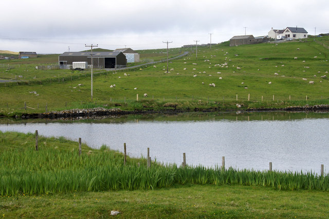
Coastal inlet Top of the coastal inlet
Coastal inlet Credit: Mat Tuck

Ayre of Dury is a stunning beach located in the remote and picturesque Shetland Islands, Scotland. Nestled on the southwestern coast of the main island, the beach offers a tranquil and idyllic setting for visitors seeking natural beauty and solitude.

Stretching for approximately half a mile, Ayre of Dury boasts pristine white sands that contrast beautifully with the turquoise waters of the North Sea. The beach is flanked by rocky cliffs and rolling dunes, creating a dramatic backdrop against the vast expanse of the ocean. Visitors can enjoy breathtaking panoramic views of the surrounding landscape, including the nearby rugged coastline and distant islands.

Ayre of Dury is also known for its rich biodiversity. The beach is home to a diverse range of bird species, making it a popular spot for birdwatching enthusiasts. Visitors may spot rare seabirds such as kittiwakes, fulmars, and puffins, adding to the charm of this remote oasis.

The beach offers a peaceful and secluded setting, perfect for leisurely walks along the shore, picnics, or simply soaking up the serene atmosphere. It is important to note that Ayre of Dury can only be accessed by a scenic coastal path or by boat, adding to its off-the-beaten-path allure.

For those seeking an escape from the hustle and bustle of everyday life, Ayre of Dury provides a tranquil haven where visitors can immerse themselves in the beauty of nature and truly unwind.

If you have any feedback on the listing, please let us know in the comments section below.

Ayre of Dury Images

Images are sourced within 2km of 60.324219/-1.1681097 or Grid Reference HU4660. Thanks to Geograph Open Source API. All images are credited.

Coastal inlet Top of the coastal inlet
Coastal inlet
Top of the coastal inlet
The Vadill, Billister, at high tide Vadill means a place that can be waded across, but the tide is in.
The Vadill, Billister, at high tide
Vadill means a place that can be waded across, but the tide is in.
Head of the Vadill, Billister The pink plant on the left is a garden escape, Sweet Rocket.
Head of the Vadill, Billister
The pink plant on the left is a garden escape, Sweet Rocket.
North Nesting Public Hall. Laxfirth
Quoys pier Pier at Quoys
Quoys pier
Pier at Quoys
Wind turbine Wind turbine installation
Wind turbine
Wind turbine installation
Ayre of Atler View across to the pier
Ayre of Atler
View across to the pier
Quoys pier A small piece of land by Quoys Pier.  There is a picnic bench and space to pull up several cars, making a useful wild camping spot.
Quoys pier
A small piece of land by Quoys Pier. There is a picnic bench and space to pull up several cars, making a useful wild camping spot.
The head of Dury Voe, North Nesting, at high tide
High tide at the head of Dury Voe, North Nesting
Billister: the pier A tiny harbour on Lax Firth, an inlet from the much larger Dury Voe, which is in the background.
Billister: the pier
A tiny harbour on Lax Firth, an inlet from the much larger Dury Voe, which is in the background.
Billister: old Zetland County Council stone This small slab of stone is almost hidden in the long grass opposite the pier (see <a href="https://www.geograph.org.uk/photo/2758868">HU4760 : Billister: the pier</a>) and is inscribed with the Zetland County Council emblem with the name Billister Pier below.

Zetland County Council is the predecessor (1974) to the present-day Shetland Islands Council.
Billister: old Zetland County Council stone
This small slab of stone is almost hidden in the long grass opposite the pier (see HU4760 : Billister: the pier) and is inscribed with the Zetland County Council emblem with the name Billister Pier below. Zetland County Council is the predecessor (1974) to the present-day Shetland Islands Council.
Billister: the telephone box Looking down the lane towards Billister pier, with a red telephone box on the right. The box also acts as the repository for post for the wheelchair-bound lady, who lives in the cottage, as I discovered when I found a letter (visible on the shelf) inside the box. I knocked on the door and she cheerfully told me that her home help or other visitors checked the box before coming in.
Billister: the telephone box
Looking down the lane towards Billister pier, with a red telephone box on the right. The box also acts as the repository for post for the wheelchair-bound lady, who lives in the cottage, as I discovered when I found a letter (visible on the shelf) inside the box. I knocked on the door and she cheerfully told me that her home help or other visitors checked the box before coming in.
Billister, North Nesting Three houses of different ages, possibly even built in different centuries.
Billister, North Nesting
Three houses of different ages, possibly even built in different centuries.
Billister pier, North Nesting Formerly the route to Whalsay.
Billister pier, North Nesting
Formerly the route to Whalsay.
Ruined crofthouse beside Lax Firth, North Nesting
Peatslide on the slopes of Riven Hill Taken from the Whalsay ferry.
Peatslide on the slopes of Riven Hill
Taken from the Whalsay ferry.
Fish farm in Loura Voe, Dury Voe Taken from the Whalsay ferry (photographer grid reference taken from GPS).
Fish farm in Loura Voe, Dury Voe
Taken from the Whalsay ferry (photographer grid reference taken from GPS).
Show me another place!

Ayre of Dury is located at Grid Ref: HU4660 (Lat: 60.324219, Lng: -1.1681097)

Unitary Authority: Shetland Islands

Police Authority: Highlands and Islands

What 3 Words

///reworked.slyly.exist. Near Vidlin, Shetland Islands

Nearby Locations

Ayre of Dury

Related Wikis

Billister

Billister is a settlement in the parish of Nesting, on the island of Mainland, in Shetland, Scotland. It is on Lax Firth. Billister was formerly the terminal...

Geopark Shetland

Geopark Shetland is the name used by the Geopark formally established in September 2009 on its entry into the European Geoparks Network. The Geopark extends...

Nesting, Shetland

Nesting is a parish in the Shetland Islands, Scotland. It includes a part of the east Shetland Mainland, measuring about twelve by four miles (19 by 6...

Brettabister

Brettabister is a settlement on the island of Mainland in Shetland, Scotland. It is in the parish of Nesting. St. Ola's parish church lies to the east...

Viking Wind Farm

Viking Wind Farm is a large on-shore wind farm under construction in the Shetland Islands which is being developed by Viking Energy, a partnership between...

Laxo

Laxo is a small settlement at the end of Laxo Voe in Vidlin, Shetland, Scotland. A ferry from the Mainland to Symbister in Whalsay operates from the nearby...

Neap

Neap is a small village in the east coast of the Mainland of the Shetland Islands, Scotland. Neap is situated at the end of the road from Brettabister...

Central Mainland

The Central Mainland of the Shetland Islands is the part of the Mainland, the largest of the Shetland Islands, Scotland. It is located between Hellister...

Nearby Amenities

Located within 500m of 60.324219,-1.1681097
Barrier: cattle_grid
Lat/Long: 60.3269063/-1.1744426
Power: pole
Lat/Long: 60.3201503/-1.1702335
Power: pole
Lat/Long: 60.3206593/-1.1704063
Power: pole
Lat/Long: 60.3214082/-1.1706838
Power: pole
Lat/Long: 60.322023/-1.1709112
Power: pole
Lat/Long: 60.3225556/-1.1711091
Power: pole
Lat/Long: 60.3230904/-1.171291
Power: pole
Lat/Long: 60.3237705/-1.1715389
Power: pole
Lat/Long: 60.324427/-1.1717822
Power: pole
Lat/Long: 60.324928/-1.1721438
Power: pole
Lat/Long: 60.3255146/-1.1725737
Power: pole
Lat/Long: 60.3262172/-1.1730876
Power: pole
Lat/Long: 60.3268341/-1.1735425
Power: pole
Lat/Long: 60.32737/-1.1739291
The data included in this document is from www.openstreetmap.org. The data is made available under ODbL.

Have you been to Ayre of Dury?

Leave your review of Ayre of Dury below (or comments, questions and feedback).