East Ayre

Beach in Shetland

Scotland

East Ayre

Ness of Hillwick Taken from the B9078 between Burnside and Eshaness, Shetland, I am looking across Sand Wick to the Ness of Hillswick. The Isle of Westerhouse is visible just off the Pund of Grevasand to the west of the Ness.
Ness of Hillwick Credit: Carroll Pierce

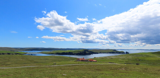
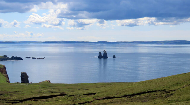
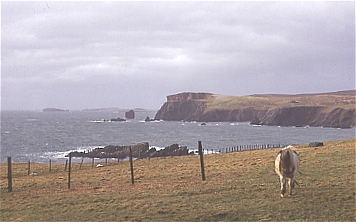
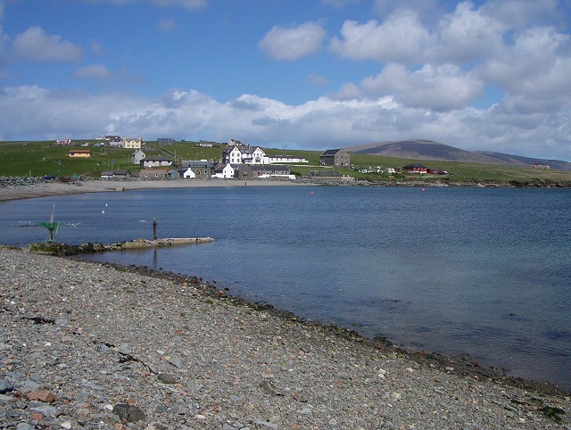
East Ayre is a picturesque beach located in the Shetland Islands, Scotland. Situated on the eastern coast of the mainland, it offers a breathtaking view of the North Sea and is known for its untouched natural beauty. Stretching over a mile, the beach is a combination of soft white sand and pebbles, making it a perfect spot for a leisurely stroll or a relaxing picnic.

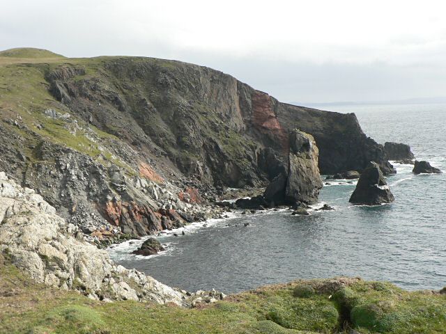
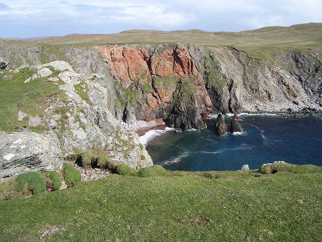
The beach is surrounded by grassy dunes and low cliffs, providing a sense of tranquility and seclusion. Its remote location and relatively underdeveloped infrastructure make it a hidden gem for nature lovers and those seeking a peaceful escape from city life.

East Ayre is also home to a diverse range of wildlife. Birdwatchers can spot various seabirds, including puffins, fulmars, and kittiwakes, nesting along the cliffs. Grey seals are often seen basking on the rocks, and lucky visitors may even catch a glimpse of otters in the nearby waters.

The beach is accessible via a narrow road that leads to a small car park, ensuring a sense of exclusivity for those who make the effort to visit. While there are no facilities directly on the beach, nearby villages such as Scalloway and Tingwall offer amenities such as cafes, restaurants, and accommodation options.

With its stunning natural surroundings and abundant wildlife, East Ayre is a must-visit destination for nature enthusiasts and those seeking a peaceful retreat amidst the rugged beauty of the Shetland Islands.

If you have any feedback on the listing, please let us know in the comments section below.
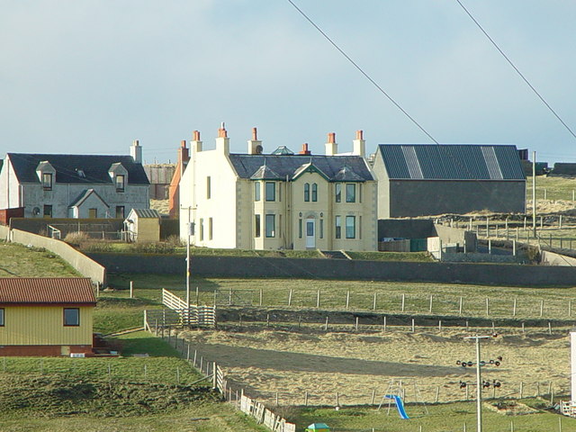
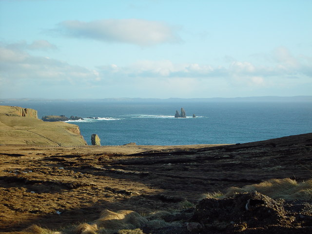
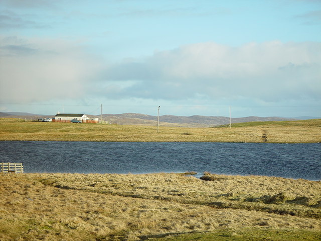
East Ayre Images

Images are sourced within 2km of 60.474714/-1.4890927 or Grid Reference HU2876. Thanks to Geograph Open Source API. All images are credited.
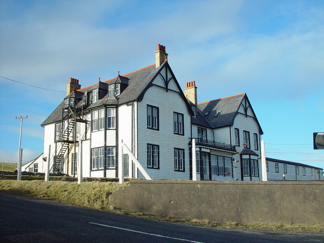
Ness of Hillwick Taken from the B9078 between Burnside and Eshaness, Shetland, I am looking across Sand Wick to the Ness of Hillswick. The Isle of Westerhouse is visible just off the Pund of Grevasand to the west of the Ness.
Ness of Hillwick
Taken from the B9078 between Burnside and Eshaness, Shetland, I am looking across Sand Wick to the Ness of Hillswick. The Isle of Westerhouse is visible just off the Pund of Grevasand to the west of the Ness.
The Drongs Taken from the B9078 between Burnside and Eshaness, Shetland, I am looking across Sand Wick to the sea stacks known at The Drongs. Papa Stour can be seen in the distance.
The Drongs
Taken from the B9078 between Burnside and Eshaness, Shetland, I am looking across Sand Wick to the sea stacks known at The Drongs. Papa Stour can be seen in the distance.
St Magnus Bay Hotel, Hillswick, Shetland Built in 1900 by the North of Scotland Ferry company. Still functioning, just [in 2004], but the absentee landlord is clearly not interested in maintaining it as a hotel, which is sad.
St Magnus Bay Hotel, Hillswick, Shetland
Built in 1900 by the North of Scotland Ferry company. Still functioning, just [in 2004], but the absentee landlord is clearly not interested in maintaining it as a hotel, which is sad.
Urafirth Primary School, Shetland Built around ten years ago Urafirth Primary School lies between Urafirth and Hillswick and pupils who live in the north west mainland of Shetland attend. Its nursery is also attended by pupils from as far away as Ollaberry.
Urafirth Primary School, Shetland
Built around ten years ago Urafirth Primary School lies between Urafirth and Hillswick and pupils who live in the north west mainland of Shetland attend. Its nursery is also attended by pupils from as far away as Ollaberry.
Hillswick Fire Station, Shetland With local retained firefighters the Hillswick Fire Station is little more than a large garage, just big enough to house the small appliance based on a large van.
Hillswick Fire Station, Shetland
With local retained firefighters the Hillswick Fire Station is little more than a large garage, just big enough to house the small appliance based on a large van.
Hillswick, Shetland Large traditionally built houses at Hillswick. In the background is Findlins House and Findlins Farm.
Hillswick, Shetland
Large traditionally built houses at Hillswick. In the background is Findlins House and Findlins Farm.
Hillswick, Shetland Houses at Hillswick, the large two storey house with mansard roof is called Laarsund.
Hillswick, Shetland
Houses at Hillswick, the large two storey house with mansard roof is called Laarsund.
St Magnus Bay Hotel, Hillswick, Shetland This hotel was built as a kit in Norway, dis-assembled and transported to Hillswick where it was constructed on its present site in 1900 by the North of Scotland, Orkney & Shetland Steam Navigation Co.. Sadly it is currently closed (April 2006) although the local community wish to see it opened again. For more information on Hillswick and surrounding area visit <span class="nowrap"><a title="http://www.undiscoveredscotland.co.uk/shetland/hillswick/index.html" rel="nofollow ugc noopener" href="http://www.undiscoveredscotland.co.uk/shetland/hillswick/index.html">Link</a><img style="margin-left:2px;" alt="External link" title="External link - shift click to open in new window" src="https://s1.geograph.org.uk/img/external.png" width="10" height="10"/></span>

UPDATE Oct 07: this hotel is now owned by a local couple and open every day - More information can be found at the official website <span class="nowrap"><a title="http://www.stmagnusbayhotel.co.uk" rel="nofollow ugc noopener" href="http://www.stmagnusbayhotel.co.uk">Link</a><img style="margin-left:2px;" alt="External link" title="External link - shift click to open in new window" src="https://s1.geograph.org.uk/img/external.png" width="10" height="10"/></span>
St Magnus Bay Hotel, Hillswick, Shetland
This hotel was built as a kit in Norway, dis-assembled and transported to Hillswick where it was constructed on its present site in 1900 by the North of Scotland, Orkney & Shetland Steam Navigation Co.. Sadly it is currently closed (April 2006) although the local community wish to see it opened again. For more information on Hillswick and surrounding area visit LinkExternal link UPDATE Oct 07: this hotel is now owned by a local couple and open every day - More information can be found at the official website LinkExternal link
View over Heads of Grocken, Eshaness, Shetland Looking out over the Heads of Grocken with 'The Drongs' the sea stacks in the distance.
View over Heads of Grocken, Eshaness, Shetland
Looking out over the Heads of Grocken with 'The Drongs' the sea stacks in the distance.
Helga water, near Hillswick, Shetland Shetland is unlikely ever to have a hosepipe ban, there are many many lochs and plentiful rainfall. This is Helga Water near the road to Eshaness.
Helga water, near Hillswick, Shetland
Shetland is unlikely ever to have a hosepipe ban, there are many many lochs and plentiful rainfall. This is Helga Water near the road to Eshaness.
Heads of Grocken Looking across the square from above Hillswick on a stormy winter's day. The pony was very inquisitive, and didn't want to be photographed in profile!
Heads of Grocken
Looking across the square from above Hillswick on a stormy winter's day. The pony was very inquisitive, and didn't want to be photographed in profile!
Heads of Grocken Small sea-stacks off the Heads of Grocken, with the Drongs in the distance.
Heads of Grocken
Small sea-stacks off the Heads of Grocken, with the Drongs in the distance.
The Quilse
The Quilse
Cliffs and stack The view south from this point is spectacular.

(The stack and the point to the right lie in this grid square, while the cliff to the left is in <a href="https://www.geograph.org.uk/gridref/HU2775">HU2775</a>).
Cliffs and stack
The view south from this point is spectacular. (The stack and the point to the right lie in this grid square, while the cliff to the left is in HU2775).
The bay at Hillswick Looking across the bay with the main settlement on the far shore.
The bay at Hillswick
Looking across the bay with the main settlement on the far shore.
Conflicting signs A waymarked stile gives access to the coast, while a "beware of the bull" sign warns of danger. We crossed through this field on a clockwise circuit of Ness of Hillswick without seeing any warning in the other direction (or a bull).
Conflicting signs
A waymarked stile gives access to the coast, while a "beware of the bull" sign warns of danger. We crossed through this field on a clockwise circuit of Ness of Hillswick without seeing any warning in the other direction (or a bull).
Opposite a red cliff Looking across the short turf of this promontory at a red cliff across the bay.
Opposite a red cliff
Looking across the short turf of this promontory at a red cliff across the bay.
Marsh marigolds Looking across a marshy area towards Hillswick. The marsh marigolds currently in flower will be succeeded by the yellow flags behind them, not yet in bud.
Marsh marigolds
Looking across a marshy area towards Hillswick. The marsh marigolds currently in flower will be succeeded by the yellow flags behind them, not yet in bud.
Show me another place!

East Ayre is located at Grid Ref: HU2876 (Lat: 60.474714, Lng: -1.4890927)

Unitary Authority: Shetland Islands

Police Authority: Highlands and Islands

What 3 Words

///forget.path.blink. Near Brae, Shetland Islands

Related Wikis

Hillswick

Hillswick is a small village in Northmavine, on the shore of the Atlantic Ocean and lies to the north-north west of Mainland, Shetland, the most northerly...
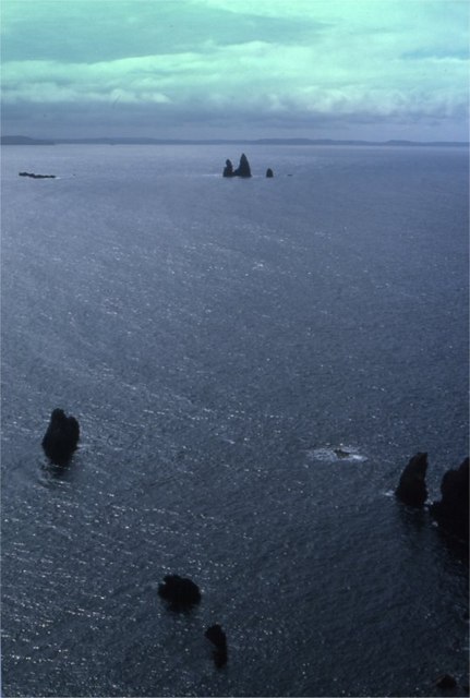
The Drongs

The Drongs are a group of sea stacks off the coast of Hillswick Ness, Northmavine, Shetland, Scotland. They lie to the west of the Isle of Westerhouse...

Assater

Assater (also spelled Assetter) is a hamlet on Mainland, in Shetland, Scotland. Assater is situated in the parish of Northmaven. It is about 1.3 miles...

Heylor

Heylor is a settlement situated on the south side of Ronas Voe in Northmavine, Shetland, Scotland. It lies directly opposite Ronas Hill, Shetland's tallest...

Battle of Ronas Voe

The Battle of Ronas Voe was a naval engagement between the English Royal Navy and the Dutch East India ship Wapen van Rotterdam on 14 March 1674 in Ronas...

Punds Water

Punds Water is a freshwater loch near Mangaster in Northmavine, Shetland. It also gives its name to a nearby Neolithic heel-shaped cairn. == Heel-shaped... ==

Gunnister

Gunnister is a small 'abandoned' village at the North-West Mainland in Shetland, Scotland. It is most commonly known for the Gunnister Man - the remains...

Braehoulland

Braehoulland is a hamlet on Mainland, in Shetland, Scotland. Braehoulland is situated within the parish of Northmaven. Eshaness Community Centre is located...

Nearby Amenities

Located within 500m of 60.474714,-1.4890927
Hillswick
Place: village
Wikidata: Q5764039
Wikipedia: en:Hillswick
Lat/Long: 60.4765334/-1.4875893
Toilets
Note: location approximate
Lat/Long: 60.4757264/-1.4888302
Bus Stop
Shelter: yes
Lat/Long: 60.4763958/-1.4882866
Post Box
Operator: Royal Mail
Post Box Type: lamp
Ref: ZE2 84
Lat/Long: 60.4761716/-1.4881594
Barrier: cattle_grid
Lat/Long: 60.4747921/-1.4899319
Recycling
Lat/Long: 60.4755416/-1.4894075
Telephone
Booth: K6
Covered: booth
Lat/Long: 60.4761285/-1.4880128
Barrier: cattle_grid
Lat/Long: 60.4746083/-1.489715
Power: pole
Lat/Long: 60.4763757/-1.4868795
Power: pole
Lat/Long: 60.4765044/-1.4869682
Power: pole
Lat/Long: 60.4766107/-1.4870473
Power: pole
Lat/Long: 60.4768918/-1.487287
Power: pole
Lat/Long: 60.4771835/-1.4875266
Power: pole
Lat/Long: 60.4774587/-1.4877615
Power: pole
Lat/Long: 60.477748/-1.4880395
Power: pole
Lat/Long: 60.478009/-1.488272
Power: pole
Lat/Long: 60.4783763/-1.4882241
Power: pole
Lat/Long: 60.4787164/-1.4881641
Power: pole
Lat/Long: 60.4772414/-1.4874595
Power: pole
Lat/Long: 60.4778449/-1.4890653
Power: pole
Lat/Long: 60.4776488/-1.4899544
Power: pole
Lat/Long: 60.4786904/-1.4902996
Power: pole
Lat/Long: 60.4781732/-1.490127
Power: pole
Lat/Long: 60.4770996/-1.4897411
Power: pole
Lat/Long: 60.4765694/-1.4895734
Power: pole
Lat/Long: 60.4762529/-1.4894703
Power: pole
Lat/Long: 60.4756671/-1.489269
Power: pole
Lat/Long: 60.4751391/-1.4895254
Power: pole
Lat/Long: 60.4746195/-1.4898178
Power: pole
Lat/Long: 60.4739592/-1.490393
Power: pole
Lat/Long: 60.4735352/-1.4906519
Power: pole
Lat/Long: 60.4729482/-1.4909706
Power: pole
Lat/Long: 60.476789/-1.488864
Power: pole
Lat/Long: 60.4769615/-1.4883439
Power: pole
Lat/Long: 60.4774917/-1.4866854
Power: pole
Lat/Long: 60.4778508/-1.4855542
Power: pole
Lat/Long: 60.4782121/-1.4844685
Power: pole
Lat/Long: 60.4770099/-1.4859185
Power: pole
Lat/Long: 60.4762363/-1.4886147
Give Way
Direction: backward
Lat/Long: 60.4764308/-1.4883771
Give Way
Direction: backward
Lat/Long: 60.476478/-1.4884178
The data included in this document is from www.openstreetmap.org. The data is made available under ODbL.

Have you been to East Ayre?

Leave your review of East Ayre below (or comments, questions and feedback).