Bantham Sand

Beach in Devon South Hams

England

Bantham Sand

Yarmouth Sand Loam Castle <a title="https://www.geograph.org.uk/search.php?i=155565115" href="https://www.geograph.org.uk/search.php?i=155565115">Link</a> is the headland at the north end of the beach. The distant headlands are Rame Head and Stoke Point.
Yarmouth Sand Credit: Derek Harper

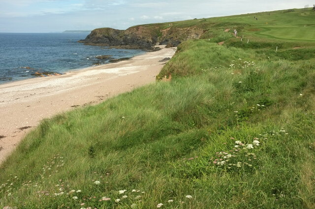
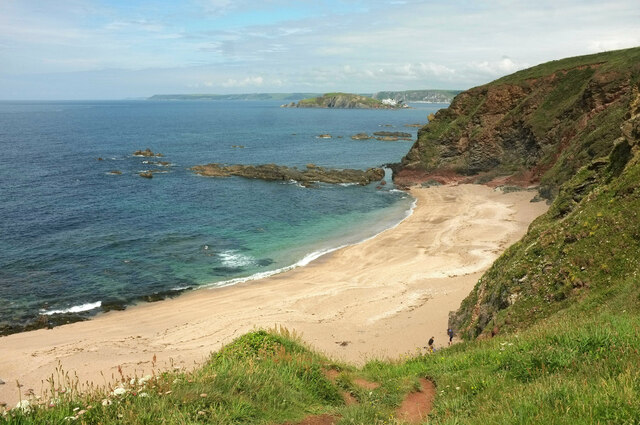
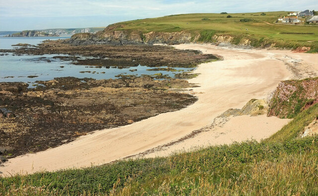
Bantham Sand, located in Devon, England, is a picturesque beach renowned for its stunning natural beauty and pristine sandy shores. Spanning approximately 1.5 kilometers, this coastal gem attracts locals and tourists alike.

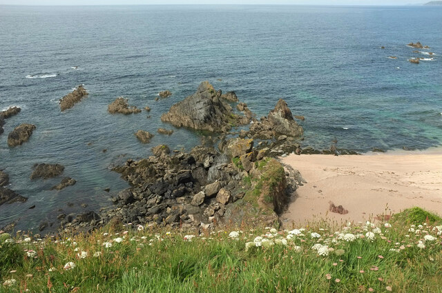
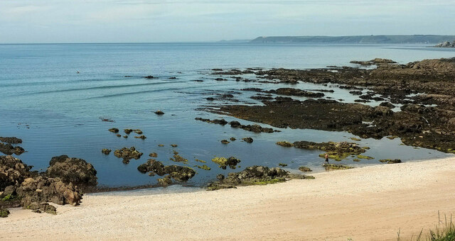
The beach is situated at the mouth of the River Avon, creating a tranquil and idyllic setting. The golden sand stretches far and wide, providing ample space for beachgoers to relax, play, and enjoy various recreational activities. The sand is soft and fine, making it perfect for sunbathing, building sandcastles, or simply strolling along the shore.

Bantham Sand is a popular destination for water sports enthusiasts. Its location offers excellent conditions for surfing, paddleboarding, and kayaking, attracting surfers of all skill levels. The large waves and consistent swells make it an ideal spot for catching some thrilling rides.

The beach is backed by rolling sand dunes and bordered by lush grassy cliffs, providing a stunning backdrop and offering a sense of seclusion and privacy. It is also surrounded by beautiful countryside, making it a great starting point for scenic walks and hikes.

Facilities at Bantham Sand include a car park, public toilets, and a beach café where visitors can grab a bite to eat or a refreshing drink. Lifeguards patrol the beach during peak seasons, ensuring the safety of swimmers and water sports enthusiasts.

Overall, Bantham Sand in Devon is a picturesque beach that offers a serene and scenic coastal experience, making it a must-visit destination for nature lovers and beach enthusiasts.

If you have any feedback on the listing, please let us know in the comments section below.

Bantham Sand Images

Images are sourced within 2km of 50.280503/-3.8879033 or Grid Reference SX6543. Thanks to Geograph Open Source API. All images are credited.

Yarmouth Sand Loam Castle <a title="https://www.geograph.org.uk/search.php?i=155565115" href="https://www.geograph.org.uk/search.php?i=155565115">Link</a> is the headland at the north end of the beach. The distant headlands are Rame Head and Stoke Point.
Yarmouth Sand
Loam Castle Link is the headland at the north end of the beach. The distant headlands are Rame Head and Stoke Point.
Broad Sand A cove between Yarmouth Sand and Bantham Sand. Ahead is Burgh Island with its hotel.
Broad Sand
A cove between Yarmouth Sand and Bantham Sand. Ahead is Burgh Island with its hotel.
Rocks by Broad Sand Looking left from <a href="https://www.geograph.org.uk/photo/7153086">SX6642 : Broad Sand</a>.
Rocks by Broad Sand
Looking left from SX6642 : Broad Sand.
Goatsbeard near Butter Cove Tragopogon pratensis by the clifftop coastal path.
Goatsbeard near Butter Cove
Tragopogon pratensis by the clifftop coastal path.
Headland and Long Stone The long stone is seen from sea level at <a href="https://www.geograph.org.uk/photo/6229771">SX6543 : Long Stone</a>. Here it is seen from the clifftop coast path.
Headland and Long Stone
The long stone is seen from sea level at SX6543 : Long Stone. Here it is seen from the clifftop coast path.
Cliff southeast of Butter Cove And northwest of Broad Sand. A wide grassy shelf has developed a little down from the clifftop.
Cliff southeast of Butter Cove
And northwest of Broad Sand. A wide grassy shelf has developed a little down from the clifftop.
Rocks near Loam Castle The principal stack can be seen on the left of <a href="https://www.geograph.org.uk/photo/5924310">SX6642 : Rocks, Loam Castle</a>.
Rocks near Loam Castle
The principal stack can be seen on the left of SX6642 : Rocks, Loam Castle.
Yarmer Beach A sandy cove with broad wave-cut platforms north of Warren Point, seen from the coast path. Burgh Island is glimpsed on the left.
Yarmer Beach
A sandy cove with broad wave-cut platforms north of Warren Point, seen from the coast path. Burgh Island is glimpsed on the left.
Rocks, Yarmer Beach Across the sandy beach and rocks exposed at low tide.
Rocks, Yarmer Beach
Across the sandy beach and rocks exposed at low tide.
Hole in the coast path near Thurlestone A tripod of poles deters the unwary.
Hole in the coast path near Thurlestone
A tripod of poles deters the unwary.
Path above the Avon estuary Walkers follow Thurlestone footpath 19 along a ridge to meet the coast path above the Long Stone. The tide is out and Burgh Island, partly obscured, is linked to the mainland, while sandbanks predominate in the Avon estuary.
Path above the Avon estuary
Walkers follow Thurlestone footpath 19 along a ridge to meet the coast path above the Long Stone. The tide is out and Burgh Island, partly obscured, is linked to the mainland, while sandbanks predominate in the Avon estuary.
Wave-cut platform near Bantham Sand Looking towards Burgh Island, linked at low tide to Bigbury-on-Sea on the mainland..
Wave-cut platform near Bantham Sand
Looking towards Burgh Island, linked at low tide to Bigbury-on-Sea on the mainland..
Cattle, Bantham A thoroughly bucolic scene by the Buckland Stream next to the car park for Bantham Sand.
Cattle, Bantham
A thoroughly bucolic scene by the Buckland Stream next to the car park for Bantham Sand.
Avon estuary at Bantham From near the payment booth for the car park, looking upstream.
Avon estuary at Bantham
From near the payment booth for the car park, looking upstream.
Buckland Stream valley Thurlestone footpath 4 plunges steeply down the valley side past the corner of a small wood and climbs less steeply into Bantham.
Buckland Stream valley
Thurlestone footpath 4 plunges steeply down the valley side past the corner of a small wood and climbs less steeply into Bantham.
Bantham The village seen across the Buckland Stream valley. Unnamed woods line the slopes across the (almost) entirely hidden Avon estuary.
Bantham
The village seen across the Buckland Stream valley. Unnamed woods line the slopes across the (almost) entirely hidden Avon estuary.
Path above the Avon estuary Looking the other way from <a href="https://www.geograph.org.uk/photo/7204304">SX6643 : Path above the Avon estuary</a> along Thurlestone footpath 19.
Path above the Avon estuary
Looking the other way from SX6643 : Path above the Avon estuary along Thurlestone footpath 19.
Buckland Stream valley Looking left from <a href="https://www.geograph.org.uk/photo/7205577">SX6643 : Path above the Avon estuary</a>, with the villages of Bantham (left) and West Buckland (right).
Buckland Stream valley
Looking left from SX6643 : Path above the Avon estuary, with the villages of Bantham (left) and West Buckland (right).
Show me another place!

Bantham Sand is located at Grid Ref: SX6543 (Lat: 50.280503, Lng: -3.8879033)

Administrative County: Devon

District: South Hams

Police Authority: Devon and Cornwall

What 3 Words

///producers.magnetic.showcase. Near Modbury, Devon

Related Wikis

River Avon, Devon

The River Avon, also known as the River Aune, is a river in the county of Devon in the southwest of England. It rises in the southern half of Dartmoor...

Bigbury-on-Sea

Bigbury-on-Sea is a village in the South Hams district on the south coast of Devon, England. It is part of the civil parish of Bigbury which is centred...

Burgh Island Hotel

The Burgh Island Hotel is a hotel on Burgh Island, Devon in England. == History == In the 1890s, the music hall star George H. Chirgwin built a prefabricated...

Burgh Island

Burgh Island is a tidal island on the coast of South Devon in England near the small seaside village of Bigbury-on-Sea. There are several buildings on...

Nearby Amenities

Located within 500m of 50.280503,-3.8879033
Source: PGS
Lat/Long: 50.2775088/-3.8830436
Source: PGS
Lat/Long: 50.277213/-3.8835908
Source: PGS
Lat/Long: 50.27709/-3.8834789
Source: PGS
Lat/Long: 50.2770342/-3.8837729
Source: PGS
Lat/Long: 50.2770251/-3.883954
Source: PGS
Lat/Long: 50.277511/-3.8829437
Generator Method: photovoltaic
Generator Output Electricity: yes
Generator Source: solar
Generator Type: solar_photovoltaic_panel
Location: roof
Power: generator
Lat/Long: 50.283814/-3.889297
Generator Method: photovoltaic
Generator Output Electricity: yes
Generator Source: solar
Generator Type: solar_photovoltaic_panel
Location: roof
Power: generator
Lat/Long: 50.2837737/-3.8892473
Generator Method: photovoltaic
Generator Output Electricity: yes
Generator Source: solar
Generator Type: solar_photovoltaic_panel
Location: roof
Power: generator
Lat/Long: 50.2838431/-3.8885553
Generator Method: photovoltaic
Generator Output Electricity: yes
Generator Source: solar
Generator Type: solar_photovoltaic_panel
Location: roof
Power: generator
Lat/Long: 50.2838945/-3.8886304
Generator Method: photovoltaic
Generator Output Electricity: yes
Generator Source: solar
Generator Type: solar_photovoltaic_panel
Location: roof
Power: generator
Lat/Long: 50.2838705/-3.8886143
Generator Method: photovoltaic
Generator Output Electricity: yes
Generator Source: solar
Generator Type: solar_photovoltaic_panel
Location: roof
Power: generator
Lat/Long: 50.2838277/-3.8882107
Generator Method: photovoltaic
Generator Output Electricity: yes
Generator Source: solar
Generator Type: solar_photovoltaic_panel
Location: roof
Power: generator
Lat/Long: 50.2838945/-3.8882764
Generator Method: photovoltaic
Generator Output Electricity: yes
Generator Source: solar
Generator Type: solar_photovoltaic_panel
Location: roof
Power: generator
Lat/Long: 50.28373/-3.8890301
Generator Method: photovoltaic
Generator Output Electricity: yes
Generator Source: solar
Generator Type: solar_photovoltaic_panel
Location: roof
Power: generator
Lat/Long: 50.2834678/-3.8916037
Generator Method: photovoltaic
Generator Output Electricity: yes
Generator Source: solar
Generator Type: solar_photovoltaic_panel
Location: roof
Power: generator
Lat/Long: 50.2835072/-3.8913944
Post Box
Brand: Royal Mail
Brand Wikidata: Q638098
Brand Wikipedia: en:Royal Mail
Collection Times: Mo-Fr 12:00; Sa 10:45; Su off
Operator: Royal Mail
Operator Wikidata: Q638098
Post Box Design: type_b
Post Box Mounting: stone_wall
Post Box Type: wall
Ref: TQ7 94
Royal Cypher: GR
Royal Cypher Wikidata: Q33102273
Source: survey;streetlevel imagery;aerial imagery
Lat/Long: 50.2827002/-3.8929725
Life Ring
Emergency: life_ring
Survey Date: 2022-02-06
Lat/Long: 50.2825406/-3.8916244
Waste Basket
Survey Date: 2022-02-06
Lat/Long: 50.2828755/-3.8910193
Bench
Survey Date: 2022-02-06
Lat/Long: 50.2837203/-3.8908471
Waste Basket
Survey Date: 2022-02-06
Lat/Long: 50.2828677/-3.8910208
Fire Hydrant
Emergency: fire_hydrant
Fire Hydrant Type: underground
Survey Date: 2022-02-06
Lat/Long: 50.283601/-3.8905386
Fire Hydrant
Emergency: fire_hydrant
Fire Hydrant Position: lane
Fire Hydrant Type: underground
Survey Date: 2022-02-06
Lat/Long: 50.2829062/-3.8910231
The data included in this document is from www.openstreetmap.org. The data is made available under ODbL.

Have you been to Bantham Sand?

Leave your review of Bantham Sand below (or comments, questions and feedback).