Brownslade Bay

Beach in Pembrokeshire

Wales

Brownslade Bay

Tenby (North Beach) Tenby North Beach at low tide
Tenby (North Beach) Credit: Ryan Griffiths

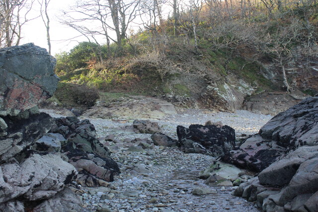
Brownslade Bay is a charming and secluded beach located on the stunning Pembrokeshire coastline in Wales. Nestled between the popular beaches of Little Haven and Broad Haven, this hidden gem offers a tranquil and serene escape for visitors seeking a quieter beach experience.

With its golden sandy shoreline, Brownslade Bay is a picturesque spot that boasts breathtaking views of the rugged cliffs and crystal-clear waters. The beach is surrounded by dramatic headlands, creating a sense of privacy and seclusion. It is accessible via a scenic coastal path, which adds to the adventure of reaching this hidden cove.

Due to its slightly more remote location, Brownslade Bay tends to have fewer crowds compared to its neighboring beaches. This makes it an ideal spot for those looking to relax, unwind, and enjoy the peace and tranquility of nature. The beach is also popular among nature enthusiasts and birdwatchers, as it forms part of the Pembrokeshire Coast National Park and offers opportunities to spot a wide variety of bird species.

While Brownslade Bay does not offer the typical facilities found in busier beaches, its simplicity is part of its charm. Visitors are encouraged to bring their own food, drinks, and beach essentials. It is important to note that there are no lifeguards on duty, so caution should be exercised when swimming in the bay.

Overall, Brownslade Bay provides a serene and idyllic coastal experience, allowing visitors to connect with nature and enjoy the natural beauty of Pembrokeshire's coastline in a peaceful setting.

If you have any feedback on the listing, please let us know in the comments section below.

Brownslade Bay Images

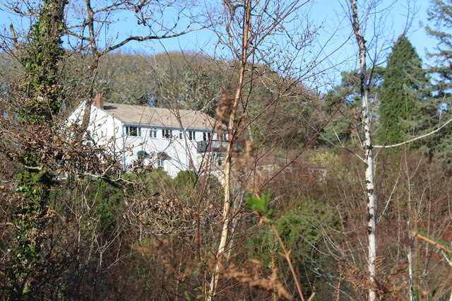
Images are sourced within 2km of 51.687509/-4.693964 or Grid Reference SN1302. Thanks to Geograph Open Source API. All images are credited.

Tenby (North Beach) Tenby North Beach at low tide
Tenby (North Beach)
Tenby North Beach at low tide
Tenby Harbour  Tenby Harbour at low tide
Tenby Harbour
Tenby Harbour at low tide
Tenby (town centre)  Tenby town centre on this busy Saturday afternoon
Tenby (town centre)
Tenby town centre on this busy Saturday afternoon
Tenby (Castle Beach) Tenby Castle Beach at low tide
Tenby (Castle Beach)
Tenby Castle Beach at low tide
Three Mariners St George Street, Tenby.
Three Mariners
St George Street, Tenby.
The sign of Three Mariners <a href="https://www.geograph.org.uk/photo/6968598">SN1300 : Three Mariners</a>
The sign of Three Mariners
Perched houses On St Julian Street, high above the beach.
Perched houses
On St Julian Street, high above the beach.
Wooded valley below Cwmwennol Hotel Looking over a valley by the coast.
Wooded valley below Cwmwennol Hotel
Looking over a valley by the coast.
Private road  to Broadfield Hill Road through Rhode/Road Wood from Cwmwennol Hotel and holiday homes.
Private road to Broadfield Hill
Road through Rhode/Road Wood from Cwmwennol Hotel and holiday homes.
Entrance at Swallow Tree Gardens Start of the drive into a holiday home park with Saundersfoot Bay beyond.
Entrance at Swallow Tree Gardens
Start of the drive into a holiday home park with Saundersfoot Bay beyond.
Cwmwennol Hotel in woodland Viewed from track, near former coal mines, to seashore.
Cwmwennol Hotel in woodland
Viewed from track, near former coal mines, to seashore.
Path down to shore Path, alongside stream, below the Pembrokeshire Coast Path; high water.
Path down to shore
Path, alongside stream, below the Pembrokeshire Coast Path; high water.
Steps on rocky shore The concrete steps (centre) terminate the path <a href="https://www.geograph.org.uk/photo/7032347">SN1403 : Path down to shore</a> coming down from the Coast Path. The shingle is submerged at high spring tide.
Steps on rocky shore
The concrete steps (centre) terminate the path SN1403 : Path down to shore coming down from the Coast Path. The shingle is submerged at high spring tide.
Rocky shore at high tide in stormy weather Saundersfoot can be seen in the distance, right.
Rocky shore at high tide in stormy weather
Saundersfoot can be seen in the distance, right.
Pembrokeshire Coast Path near Trevayne Wood Public footpath at edge of field near edge of cliff.
Pembrokeshire Coast Path near Trevayne Wood
Public footpath at edge of field near edge of cliff.
Gate on Pembrokeshire Coast Path Gate from field to footpath between bushes to another gate into woodland; near Trevayne Farm.
Gate on Pembrokeshire Coast Path
Gate from field to footpath between bushes to another gate into woodland; near Trevayne Farm.
Steps on Pembrokeshire Coast Path The footbridge and steps head directly towards Lodge Valley bypassing the Monkstone Point loop which goes to to the left at the signpost. The arm of the post is pointing towards Saundersfoot.
Steps on Pembrokeshire Coast Path
The footbridge and steps head directly towards Lodge Valley bypassing the Monkstone Point loop which goes to to the left at the signpost. The arm of the post is pointing towards Saundersfoot.
Air shaft by Pembrokeshire Coast Path The Path comes down the lefthand side of the enclosure and across to the right of the disused shaft, a relic of the Pembrokeshire coalfield.
Air shaft by Pembrokeshire Coast Path
The Path comes down the lefthand side of the enclosure and across to the right of the disused shaft, a relic of the Pembrokeshire coalfield.
Show me another place!

Brownslade Bay is located at Grid Ref: SN1302 (Lat: 51.687509, Lng: -4.693964)

Unitary Authority: Pembrokeshire

Police Authority: Dyfed Powys

What 3 Words

///coverage.stone.dialects. Near Tenby, Pembrokeshire

Related Wikis

Broadfield, Pembrokeshire

Broadfield is a small village south of Saundersfoot in the parish and community of St Mary Out Liberty in Pembrokeshire, Wales. == References == ��2�...

New Hedges

New Hedges is a village in the community of St Mary Out Liberty, Pembrokeshire, Wales. It is midway between Saundersfoot and Tenby. The population was...

Tenby Cottage Hospital

Tenby Cottage Hospital (Welsh: Ysbyty Bwthyn Dinbych y Pysgod) is a community hospital in Tenby, Wales. It is managed by the Hywel Dda University Health...

St Mary Out Liberty

St Mary Out Liberty (also known as Tenby St Mary Out Liberty) is a community in the southeast of Pembrokeshire, Wales. The community was established in...

Nearby Amenities

Located within 500m of 51.687509,-4.693964
Bench
Lat/Long: 51.6854229/-4.7000941
Waterwynch Bay
Natural: bay
Lat/Long: 51.6854223/-4.6949061
Brownslade Bay
Natural: bay
Lat/Long: 51.6876753/-4.6939975
Waterwynch
Place: neighbourhood
Lat/Long: 51.6870955/-4.6985663
Direction: SW
Generator Method: photovoltaic
Generator Output Electricity: yes
Generator Solar Modules: 10
Generator Source: solar
Generator Type: solar_photovoltaic_panel
Location: roof
Power: generator
Lat/Long: 51.6865717/-4.6975482
Direction: SW
Generator Method: photovoltaic
Generator Output Electricity: yes
Generator Solar Modules: 10
Generator Source: solar
Generator Type: solar_photovoltaic_panel
Location: roof
Power: generator
Lat/Long: 51.6866393/-4.6976803
Direction: SW
Generator Method: photovoltaic
Generator Output Electricity: yes
Generator Solar Modules: 16
Generator Source: solar
Generator Type: solar_photovoltaic_panel
Location: roof
Power: generator
Lat/Long: 51.6865568/-4.6976821
The data included in this document is from www.openstreetmap.org. The data is made available under ODbL.

Have you been to Brownslade Bay?

Leave your review of Brownslade Bay below (or comments, questions and feedback).