Appletree Beach

Beach in Cornwall

England

Appletree Beach

Charlestown Beach A view south west along Charlestown beach from the western harbour wall.
Charlestown Beach Credit: Kevin Pearson

The requested URL returned error: 429 Too Many Requests

If you have any feedback on the listing, please let us know in the comments section below.

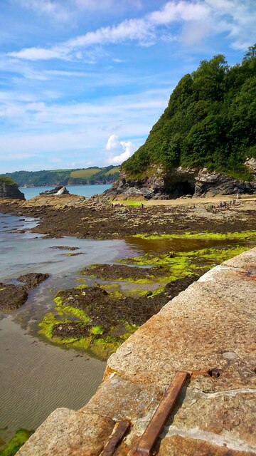
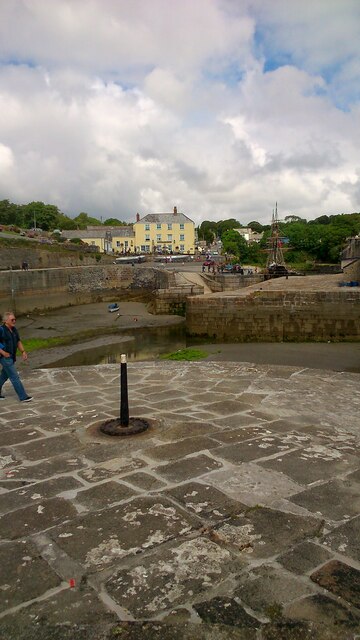
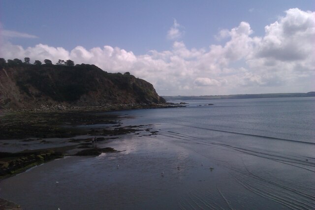
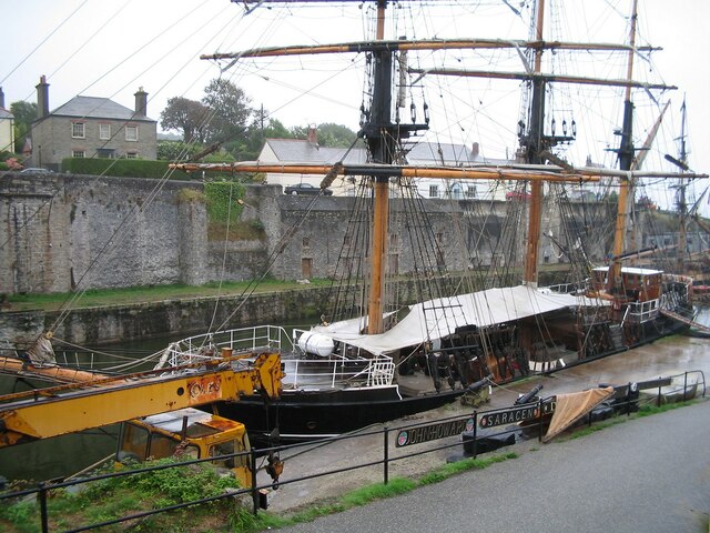
Appletree Beach Images

Images are sourced within 2km of 50.331942/-4.7493417 or Grid Reference SX0451. Thanks to Geograph Open Source API. All images are credited.

Charlestown Beach A view south west along Charlestown beach from the western harbour wall.
Charlestown Beach
A view south west along Charlestown beach from the western harbour wall.
Charletown Harbour Photograph of the entrance into Charlestown Harbour, taken from the western harbour wall.
Charletown Harbour
Photograph of the entrance into Charlestown Harbour, taken from the western harbour wall.
Charlestown Beach Charlestown Beach, looking east from the harbour entrance.
Charlestown Beach
Charlestown Beach, looking east from the harbour entrance.
Tall Ship in Charlestown Harbour Charlestown is a village and port on the south coast of Cornwall. It is situated approximately 2 miles south east of St Austell town centre.
The port at Charlestown developed in the late-18th century from the fishing village of West Polmear. Charlestown has remained relatively unchanged since. Today the main focus of the village is tourism.
Wikipedia: <span class="nowrap"><a title="https://en.wikipedia.org/wiki/Charlestown,_Cornwall" rel="nofollow ugc noopener" href="https://en.wikipedia.org/wiki/Charlestown,_Cornwall">Link</a><img style="margin-left:2px;" alt="External link" title="External link - shift click to open in new window" src="https://s1.geograph.org.uk/img/external.png" width="10" height="10"/></span>
Tall Ship in Charlestown Harbour
Charlestown is a village and port on the south coast of Cornwall. It is situated approximately 2 miles south east of St Austell town centre. The port at Charlestown developed in the late-18th century from the fishing village of West Polmear. Charlestown has remained relatively unchanged since. Today the main focus of the village is tourism. Wikipedia: LinkExternal link
Charlestown Chapel Charlestown is a village and port on the south coast of Cornwall. It is situated approximately 2 miles south east of St Austell town centre.
The port at Charlestown developed in the late-18th century from the fishing village of West Polmear. Charlestown has remained relatively unchanged since. Today the main focus of the village is tourism.
Wikipedia: <span class="nowrap"><a title="https://en.wikipedia.org/wiki/Charlestown,_Cornwall" rel="nofollow ugc noopener" href="https://en.wikipedia.org/wiki/Charlestown,_Cornwall">Link</a><img style="margin-left:2px;" alt="External link" title="External link - shift click to open in new window" src="https://s1.geograph.org.uk/img/external.png" width="10" height="10"/></span>
Charlestown Chapel
Charlestown is a village and port on the south coast of Cornwall. It is situated approximately 2 miles south east of St Austell town centre. The port at Charlestown developed in the late-18th century from the fishing village of West Polmear. Charlestown has remained relatively unchanged since. Today the main focus of the village is tourism. Wikipedia: LinkExternal link
St Austell, Polmear Road A390 approaching Mount Charles Roundabout.
St Austell, Polmear Road
A390 approaching Mount Charles Roundabout.
Railway Bridge Crossing Holmbush Road The A390 on the outskirts of St Austell.
Railway Bridge Crossing Holmbush Road
The A390 on the outskirts of St Austell.
Holmbush Road, St Austell The A390  runs for 60 miles between Tavistock and a roundabout with the A30 at Three Burrows, 5 miles north west of the city of Truro in Cornwall, via Lostwithiel, St Blazey, and St Austell. It is an important road as it forms part of the main route (the Truro to Dobwalls section) from Truro to Plymouth. It can be used to travel along the spine of Cornwall as a more leisurely drive instead of using the A30.
Holmbush Road, St Austell
The A390 runs for 60 miles between Tavistock and a roundabout with the A30 at Three Burrows, 5 miles north west of the city of Truro in Cornwall, via Lostwithiel, St Blazey, and St Austell. It is an important road as it forms part of the main route (the Truro to Dobwalls section) from Truro to Plymouth. It can be used to travel along the spine of Cornwall as a more leisurely drive instead of using the A30.
A390 Holmbush Road The A390  runs for 60 miles between Tavistock and a roundabout with the A30 at Three Burrows, 5 miles north west of the city of Truro in Cornwall, via Lostwithiel, St Blazey, and St Austell. It is an important road as it forms part of the main route (the Truro to Dobwalls section) from Truro to Plymouth. It can be used to travel along the spine of Cornwall as a more leisurely drive instead of using the A30.
A390 Holmbush Road
The A390 runs for 60 miles between Tavistock and a roundabout with the A30 at Three Burrows, 5 miles north west of the city of Truro in Cornwall, via Lostwithiel, St Blazey, and St Austell. It is an important road as it forms part of the main route (the Truro to Dobwalls section) from Truro to Plymouth. It can be used to travel along the spine of Cornwall as a more leisurely drive instead of using the A30.
Holmbush Road (A390) The A390  runs for 60 miles between Tavistock and a roundabout with the A30 at Three Burrows, 5 miles north west of the city of Truro in Cornwall, via Lostwithiel, St Blazey, and St Austell. It is an important road as it forms part of the main route (the Truro to Dobwalls section) from Truro to Plymouth. It can be used to travel along the spine of Cornwall as a more leisurely drive instead of using the A30.
Holmbush Road (A390)
The A390 runs for 60 miles between Tavistock and a roundabout with the A30 at Three Burrows, 5 miles north west of the city of Truro in Cornwall, via Lostwithiel, St Blazey, and St Austell. It is an important road as it forms part of the main route (the Truro to Dobwalls section) from Truro to Plymouth. It can be used to travel along the spine of Cornwall as a more leisurely drive instead of using the A30.
A390, St Austell Road, St Blazey Gate The A390  runs for 60 miles between Tavistock and a roundabout with the A30 at Three Burrows, 5 miles north west of the city of Truro in Cornwall, via Lostwithiel, St Blazey, and St Austell. It is an important road as it forms part of the main route (the Truro to Dobwalls section) from Truro to Plymouth. It can be used to travel along the spine of Cornwall as a more leisurely drive instead of using the A30.
A390, St Austell Road, St Blazey Gate
The A390 runs for 60 miles between Tavistock and a roundabout with the A30 at Three Burrows, 5 miles north west of the city of Truro in Cornwall, via Lostwithiel, St Blazey, and St Austell. It is an important road as it forms part of the main route (the Truro to Dobwalls section) from Truro to Plymouth. It can be used to travel along the spine of Cornwall as a more leisurely drive instead of using the A30.
Signpost in Charlestown Shipwreck centre
Harbour front
Beach
Signpost in Charlestown
Shipwreck centre Harbour front Beach
Signpost in Charlestown Art gallery
Signpost in Charlestown
Art gallery
St Paul's Church
St Paul's Church
Charlestown Chapel
Charlestown Chapel
Charlestown Cemetery
St Levan's Church
St Levan's Church
Church of Jesus Christ of Latter-day Saints
Show me another place!

Appletree Beach is located at Grid Ref: SX0451 (Lat: 50.331942, Lng: -4.7493417)

Unitary Authority: Cornwall

Police Authority: Devon and Cornwall

What 3 Words

///lifts.sprawls.initiated. Near St Austell, Cornwall

Related Wikis

Charlestown Shipwreck & Heritage Centre

The Shipwreck Treasure Museum (previously the Charlestown Shipwreck & Heritage Centre) located in the UNESCO World Heritage Site of Charlestown, Cornwall...

Charlestown, Cornwall

Charlestown (Cornish: Porth Meur, meaning great cove) is a village and port on the south coast of Cornwall, England, in the civil parish of St Austell...

St Paul's Church, Charlestown

St Paul's Church is a Church of England church in Charlestown, Cornwall, England, UK. It was built in 1849-51 and has been Grade II listed since 1999....

Carlyon

Carlyon (Cornish: Karleghyon, meaning fort of rock-slabs) is one of four new civil parishes created on 1 April 2009 for the St Austell area of south Cornwall...

Nearby Amenities

Located within 500m of 50.331942,-4.7493417
Source: PGS
Lat/Long: 50.3310356/-4.7559705
Source: PGS
Lat/Long: 50.3322046/-4.7524553
Carlyon Bay
Is In: Cornwall, England, UK
Is In Country: England
Is In Country Code: GB
Is In County: Cornwall
Name En: Carlyon Bay
Name Kw: Caryones
Place: village
Lat/Long: 50.335316/-4.7460247
Kerb: no
Lat/Long: 50.3335026/-4.7498733
Source: PGS
Lat/Long: 50.3306959/-4.7558576
Barrier: bollard
Bollard: fixed
Lat/Long: 50.3313377/-4.7556386
Seamark Light Category: vertical
Seamark Light Character: F
Seamark Light Colour: red
Seamark Light Height: 5
Seamark Light Multiple: 2
Seamark Light Range: 1
Seamark Light Reference: A 0080.2
Seamark Type: light_minor
Source: US NGA Pub. 114. 2011-05-26.
Lat/Long: 50.3305029/-4.7558295
Seamark Light Category: vertical
Seamark Light Character: F
Seamark Light Colour: green
Seamark Light Height: 5
Seamark Light Multiple: 2
Seamark Light Range: 1
Seamark Light Reference: A 0080
Seamark Type: light_minor
Source: US NGA Pub. 114. 2011-05-26.
Lat/Long: 50.3307657/-4.7558859
Barrier: kissing_gate
Lat/Long: 50.3345262/-4.7440128
Porth Avalion Hotel
Addr City: St Austell
Addr Country: GB
Addr Housenumber: 51
Addr Place: Carlyon Bay
Addr Postcode: PL25 3SG
Addr Street: Sea Road
Air Conditioning: yes
Fhrs Id: 502439
Source Addr: FHRS Open Data
Tourism: hotel
Lat/Long: 50.3331534/-4.7477831
Post Box
Brand: Royal Mail
Brand Wikidata: Q638098
Brand Wikipedia: en:Royal Mail
Collection Times: Mo-Fr 09:00; Sa 07:00
Operator: Royal Mail
Operator Wikidata: Q638098
Post Box Mounting: building
Post Box Type: wall
Ref: PL25 44D
Royal Cypher: GR
Royal Cypher Wikidata: Q33102273
Lat/Long: 50.3315697/-4.7561561
Bench
Backrest: yes
Lat/Long: 50.3324574/-4.7525951
Barrier: kissing_gate
Lat/Long: 50.3316346/-4.7550833
Generator Method: photovoltaic
Generator Output Electricity: yes
Generator Source: solar
Generator Type: solar_photovoltaic_panel
Location: roof
Power: generator
Lat/Long: 50.3327787/-4.7460884
Generator Method: photovoltaic
Generator Output Electricity: yes
Generator Source: solar
Generator Type: solar_photovoltaic_panel
Location: roof
Power: generator
Lat/Long: 50.3335149/-4.7447956
Generator Method: photovoltaic
Generator Output Electricity: yes
Generator Source: solar
Generator Type: solar_photovoltaic_panel
Location: roof
Power: generator
Lat/Long: 50.3339634/-4.7456002
Generator Method: photovoltaic
Generator Output Electricity: yes
Generator Source: solar
Generator Type: solar_photovoltaic_panel
Location: roof
Power: generator
Lat/Long: 50.3347339/-4.7461447
Generator Method: photovoltaic
Generator Output Electricity: yes
Generator Source: solar
Generator Type: solar_photovoltaic_panel
Location: roof
Power: generator
Lat/Long: 50.3351653/-4.747856
Generator Method: photovoltaic
Generator Output Electricity: yes
Generator Source: solar
Generator Type: solar_photovoltaic_panel
Location: roof
Power: generator
Lat/Long: 50.3351893/-4.747628
Generator Method: photovoltaic
Generator Output Electricity: yes
Generator Source: solar
Generator Type: solar_photovoltaic_panel
Location: roof
Power: generator
Lat/Long: 50.3360966/-4.7473866
Generator Method: photovoltaic
Generator Output Electricity: yes
Generator Source: solar
Generator Type: solar_photovoltaic_panel
Location: roof
Power: generator
Lat/Long: 50.3339651/-4.7510773
Generator Method: photovoltaic
Generator Output Electricity: yes
Generator Source: solar
Generator Type: solar_photovoltaic_panel
Location: roof
Power: generator
Lat/Long: 50.3348075/-4.7501573
Generator Method: photovoltaic
Generator Output Electricity: yes
Generator Source: solar
Generator Type: solar_photovoltaic_panel
Location: roof
Power: generator
Lat/Long: 50.3349119/-4.7495082
Generator Method: photovoltaic
Generator Output Electricity: yes
Generator Source: solar
Generator Type: solar_photovoltaic_panel
Location: roof
Power: generator
Lat/Long: 50.3337837/-4.7507957
Generator Method: photovoltaic
Generator Output Electricity: yes
Generator Source: solar
Generator Type: solar_photovoltaic_panel
Location: roof
Power: generator
Lat/Long: 50.3334361/-4.7502887
Generator Method: photovoltaic
Generator Output Electricity: yes
Generator Source: solar
Generator Type: solar_photovoltaic_panel
Location: roof
Power: generator
Lat/Long: 50.3333796/-4.7501761
Generator Method: photovoltaic
Generator Output Electricity: yes
Generator Source: solar
Generator Type: solar_photovoltaic_panel
Location: roof
Power: generator
Lat/Long: 50.3349821/-4.7522306
WW2 Pillbox
Building: bunker
Bunker Type: pillbox
Military: bunker
Lat/Long: 50.3314099/-4.7552849
Life Ring
Emergency: life_ring
Lat/Long: 50.330987/-4.7561205
Bench
Backrest: yes
Material: wood
Lat/Long: 50.3312313/-4.7562315
Life Ring
Emergency: life_ring
Lat/Long: 50.331184/-4.7562596
Bench
Backrest: yes
Material: wood
Lat/Long: 50.331145/-4.756205
Bench
Backrest: yes
Material: wood
Lat/Long: 50.3311639/-4.7562141
Bench
Backrest: yes
Material: wood
Lat/Long: 50.3311679/-4.7562345
Life Ring
Emergency: life_ring
Lat/Long: 50.330487/-4.7558142
Bench
Backrest: yes
Material: wood
Lat/Long: 50.3310096/-4.755979
Fire Hydrant
Emergency: fire_hydrant
Fire Hydrant Diameter: 100
Fire Hydrant Position: parking_lot
Fire Hydrant Type: underground
Survey Date: 2022-04-09
Lat/Long: 50.3354154/-4.7477412
Bench
Backrest: yes
Survey Date: 2022-04-09
Lat/Long: 50.3321835/-4.7466088
Waste Basket
Survey Date: 2022-04-09
Lat/Long: 50.3325813/-4.7472978
Post Box
Collection Times: Mo-Fr 09:00; Sa 07:00
Ref: PL25 128D
Royal Cypher: EIIR
Royal Cypher Wikidata: Q33102113
Survey Date: 2022-04-09
Lat/Long: 50.3356679/-4.7458231
Waste Basket
Survey Date: 2022-04-09
Lat/Long: 50.3312222/-4.7559184
Waste Basket
Survey Date: 2022-04-09
Lat/Long: 50.3311222/-4.7559712
Bench
Backrest: yes
Survey Date: 2022-04-09
Lat/Long: 50.3310577/-4.7562169
Tourism: viewpoint
Lat/Long: 50.3321892/-4.7465926
Barrier: kissing_gate
Lat/Long: 50.3331337/-4.7503499
The data included in this document is from www.openstreetmap.org. The data is made available under ODbL.

Have you been to Appletree Beach?

Leave your review of Appletree Beach below (or comments, questions and feedback).