Llanmerewig

Settlement in Montgomeryshire

Wales

Llanmerewig

Big sheds in Abermule I love an old industrial building.
Big sheds in Abermule Credit: Jeremy Bolwell

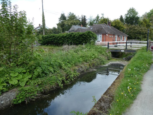
Llanmerewig is a small village located in the county of Montgomeryshire, Wales. Situated in the picturesque countryside, it lies approximately 8 miles northwest of the town of Newtown. The village is characterized by its tranquil surroundings, rolling hills, and charming rural atmosphere.

Llanmerewig is home to a close-knit community, with a population of around 200 residents. The village is primarily residential, consisting of traditional stone cottages and a small number of modern houses. The local economy is mainly based on agriculture, with farming being a significant occupation for many villagers.

One of the notable landmarks in Llanmerewig is the St. Cynllo's Church, which dates back to the 12th century. This historic church is an architectural gem, with its medieval features and beautiful stained glass windows. It serves as a spiritual and social center for the community, hosting regular services and events.

Nature enthusiasts will appreciate the natural beauty surrounding Llanmerewig. The village is nestled amidst lush green fields and woodlands, offering opportunities for scenic walks and exploration. The nearby River Severn also provides a picturesque setting for outdoor activities such as fishing and boating.

While Llanmerewig may be a small village, it benefits from its proximity to larger towns for amenities and services. Newtown, with its range of shops, schools, and healthcare facilities, is easily accessible by road.

Overall, Llanmerewig offers residents and visitors a peaceful and idyllic setting, with its charming village atmosphere and stunning countryside.

If you have any feedback on the listing, please let us know in the comments section below.

Llanmerewig Images

Images are sourced within 2km of 52.526313/-3.2411132 or Grid Reference SO1592. Thanks to Geograph Open Source API. All images are credited.

Big sheds in Abermule I love an old industrial building.
Big sheds in Abermule
I love an old industrial building.
The old Waterloo Arms public house, now a home, in Abermule Great to see such a great conversion of a sad, abandoned pub.
The old Waterloo Arms public house, now a home, in Abermule
Great to see such a great conversion of a sad, abandoned pub.
Montgomery Canal
Montgomery Canal
Canal bridge at Aberbechan
House and canal bridge at Aberbechan
Severn Way (NCN81) beside Montgomery Canal
Severn Way  (NCN81) and canal bend at Aberbechan
Severn Way (NCN81) and canal bend at Aberbechan
Severn Way and Montgomery Canal
Newhouse Wood and Montgomery Canal by Severn Way
Footbridge over Montgomery Canal near New House NCN81 (Severn Way) runs under the bridge
Footbridge over Montgomery Canal near New House
NCN81 (Severn Way) runs under the bridge
Montgomery Canal at Newhouse Wood The National Cycle Network is a network of cycle routes. It was created by the charity Sustrans <span class="nowrap"><a title="http://www.sustrans.org.uk/what-we-do/national-cycle-network" rel="nofollow ugc noopener" href="http://www.sustrans.org.uk/what-we-do/national-cycle-network">Link</a><img style="margin-left:2px;" alt="External link" title="External link - shift click to open in new window" src="https://s1.geograph.org.uk/img/external.png" width="10" height="10"/></span>  (Sustainable Transport), aided by a National Lottery grant.

Many routes aim to minimise contact with motor traffic, though 70% of them are on roads. In some cases the NCN uses pedestrian routes, disused railways, minor roads, canal towpaths, or traffic-calmed routes in towns and cities.
Montgomery Canal at Newhouse Wood
The National Cycle Network is a network of cycle routes. It was created by the charity Sustrans LinkExternal link (Sustainable Transport), aided by a National Lottery grant. Many routes aim to minimise contact with motor traffic, though 70% of them are on roads. In some cases the NCN uses pedestrian routes, disused railways, minor roads, canal towpaths, or traffic-calmed routes in towns and cities.
Swans nesting by Montgomery Canal
Montgomery Canal south of Newhouse Wood The towpath is part of the Severn Way and NCN81
Montgomery Canal south of Newhouse Wood
The towpath is part of the Severn Way and NCN81
Severn Way between the river and the canal, Aberbechan The National Cycle Network is a network of cycle routes. It was created by the charity Sustrans <span class="nowrap"><a title="http://www.sustrans.org.uk/what-we-do/national-cycle-network" rel="nofollow ugc noopener" href="http://www.sustrans.org.uk/what-we-do/national-cycle-network">Link</a><img style="margin-left:2px;" alt="External link" title="External link - shift click to open in new window" src="https://s1.geograph.org.uk/img/external.png" width="10" height="10"/></span>  (Sustainable Transport), aided by a National Lottery grant.

Many routes aim to minimise contact with motor traffic, though 70% of them are on roads. In some cases the NCN uses pedestrian routes, disused railways, minor roads, canal towpaths, or traffic-calmed routes in towns and cities.
Severn Way between the river and the canal, Aberbechan
The National Cycle Network is a network of cycle routes. It was created by the charity Sustrans LinkExternal link (Sustainable Transport), aided by a National Lottery grant. Many routes aim to minimise contact with motor traffic, though 70% of them are on roads. In some cases the NCN uses pedestrian routes, disused railways, minor roads, canal towpaths, or traffic-calmed routes in towns and cities.
B4389 bridge over Montgomery Canal The National Cycle Network is a network of cycle routes. It was created by the charity Sustrans <span class="nowrap"><a title="http://www.sustrans.org.uk/what-we-do/national-cycle-network" rel="nofollow ugc noopener" href="http://www.sustrans.org.uk/what-we-do/national-cycle-network">Link</a><img style="margin-left:2px;" alt="External link" title="External link - shift click to open in new window" src="https://s1.geograph.org.uk/img/external.png" width="10" height="10"/></span>  (Sustainable Transport), aided by a National Lottery grant.

Many routes aim to minimise contact with motor traffic, though 70% of them are on roads. In some cases the NCN uses pedestrian routes, disused railways, minor roads, canal towpaths, or traffic-calmed routes in towns and cities.
B4389 bridge over Montgomery Canal
The National Cycle Network is a network of cycle routes. It was created by the charity Sustrans LinkExternal link (Sustainable Transport), aided by a National Lottery grant. Many routes aim to minimise contact with motor traffic, though 70% of them are on roads. In some cases the NCN uses pedestrian routes, disused railways, minor roads, canal towpaths, or traffic-calmed routes in towns and cities.
Anti-skid surface on A483 near Aberbechan
B4389 to Aberbechan
B4389 to Aberbechan
A483 north-east of Cil-Gwrgan
Show me another place!

Llanmerewig is located at Grid Ref: SO1592 (Lat: 52.526313, Lng: -3.2411132)

Unitary Authority: Powys

Police Authority: Dyfed Powys

Also known as: Llamyrewig, Llanmerwig

What 3 Words

///smoker.passage.unusable. Near Newtown, Powys

Related Wikis

Llanmerewig

Llanmerewig is a historic parish in Powys, Wales, in the historic county of Montgomeryshire, and is situated between Newtown and Welshpool. The church...

Ffronfraith Halt railway station

Ffronfraith Halt railway station was a station in Llanmerewig, Powys, Wales. The station was opened on 9 July 1923 and closed on 9 February 1931. It had...
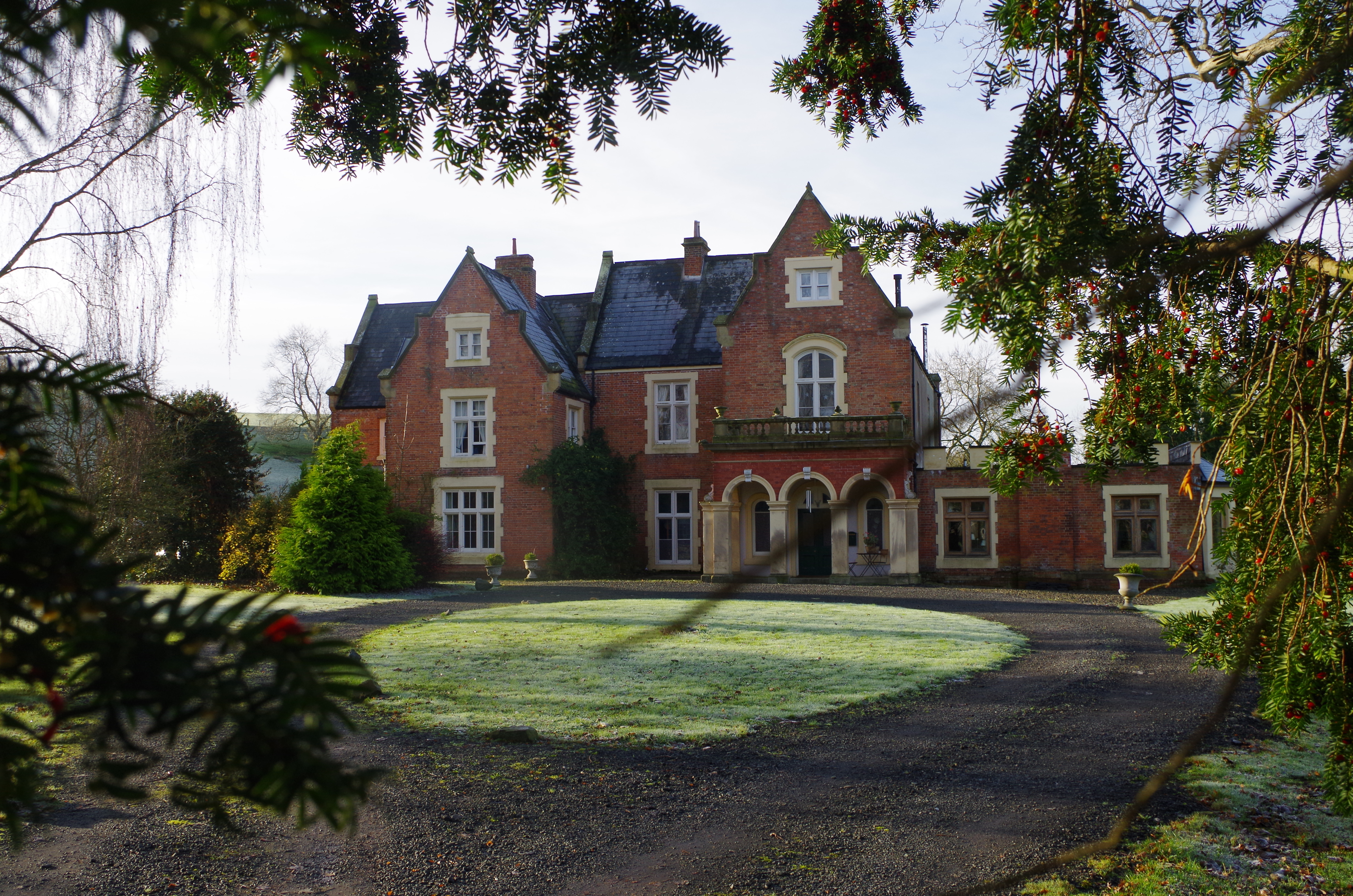
Fronfraith Hall

Fronfraith Hall is a mid-Victorian house in the historic parish of Llandyssil in the shire area of Montgomeryshire in Powys. Fronfraith also appears in...

Goitre Halt railway station

Goitre Halt railway station was a station in Llanmerewig, Powys, Wales. The station was opened on 9 July 1923 and closed on 9 February 1931. The halt was...

Nearby Amenities

Located within 500m of 52.526313,-3.2411132
Llanmerewig
Is In: Powys
Place: hamlet
Source: npe
Wikidata: Q15242566
Wikipedia: en:Llanmerewig
Lat/Long: 52.5269283/-3.2426683
Direction: 85
Generator Method: photovoltaic
Generator Output Electricity: yes
Generator Solar Modules: 8
Generator Source: solar
Generator Type: solar_photovoltaic_panel
Location: roof
Power: generator
Lat/Long: 52.526808/-3.2386199
Direction: 265
Generator Method: photovoltaic
Generator Output Electricity: yes
Generator Solar Modules: 8
Generator Source: solar
Generator Type: solar_photovoltaic_panel
Location: roof
Power: generator
Lat/Long: 52.5268019/-3.2386933
Direction: 175
Generator Method: photovoltaic
Generator Output Electricity: yes
Generator Solar Modules: 6
Generator Source: solar
Generator Type: solar_photovoltaic_panel
Location: roof
Power: generator
Lat/Long: 52.5267544/-3.2381434
Direction: 265
Generator Method: photovoltaic
Generator Output Electricity: yes
Generator Solar Modules: 10
Generator Source: solar
Generator Type: solar_photovoltaic_panel
Location: roof
Power: generator
Lat/Long: 52.5267813/-3.2382759
Direction: 275
Generator Method: photovoltaic
Generator Output Electricity: yes
Generator Solar Modules: 20
Generator Source: solar
Generator Type: solar_photovoltaic_panel
Location: roof
Power: generator
Lat/Long: 52.5272466/-3.2414248
Direction: 175
Generator Method: photovoltaic
Generator Output Electricity: yes
Generator Solar Modules: 16
Generator Source: solar
Generator Type: solar_photovoltaic_panel
Location: roof
Power: generator
Lat/Long: 52.5298323/-3.2444094
Booth: K6
Covered: booth
Disused Amenity: telephone
Man Made: telephone_box
Tourism: information
Lat/Long: 52.5264565/-3.2406426
Post Box
Post Box Type: lamp
Royal Cypher: EIIR
Royal Cypher Wikidata: Q33102113
Lat/Long: 52.5264576/-3.2406944
Give Way
Direction: forward
Lat/Long: 52.5263954/-3.2410317
The data included in this document is from www.openstreetmap.org. The data is made available under ODbL.

Have you been to Llanmerewig?

Leave your review of Llanmerewig below (or comments, questions and feedback).