Carn ar Wig

Beach in Pembrokeshire

Wales

Carn ar Wig

Carnysgubor and The Bungalow, Ramsey Island
Carnysgubor and The Bungalow, Ramsey Island Credit: Michael Steele

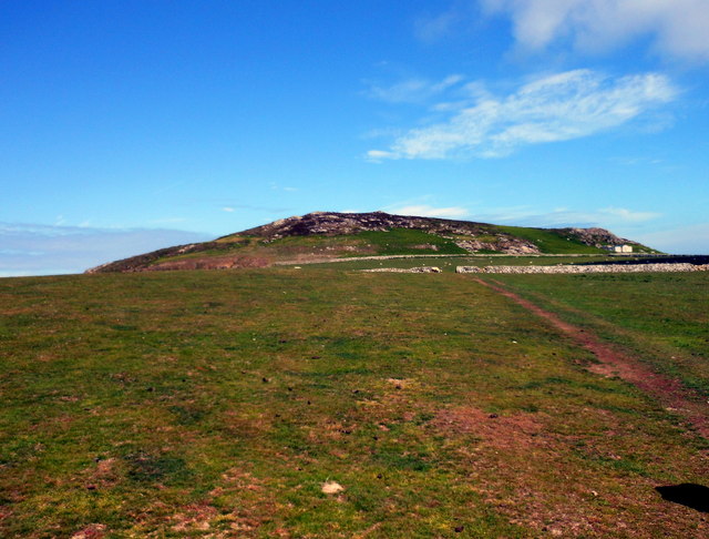
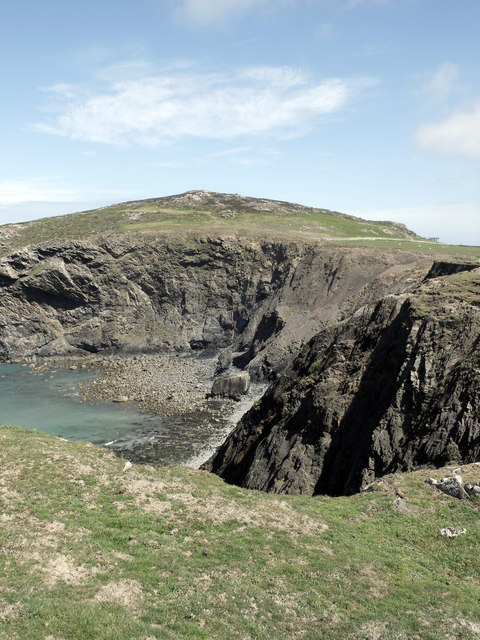
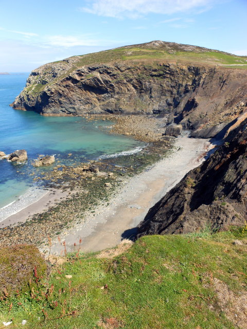
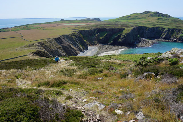
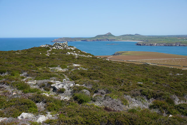
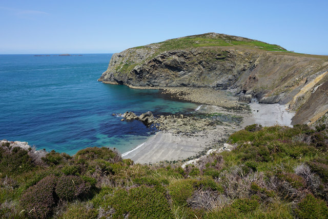
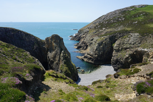
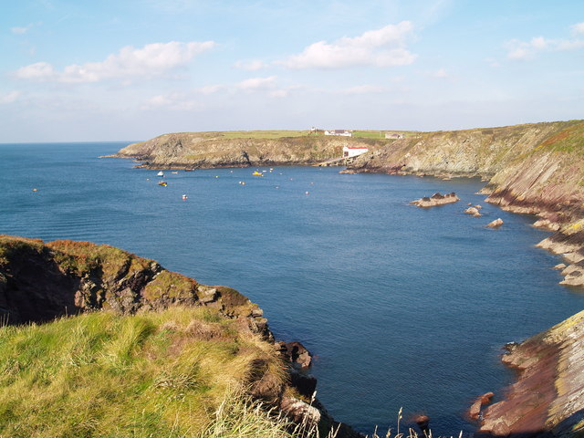
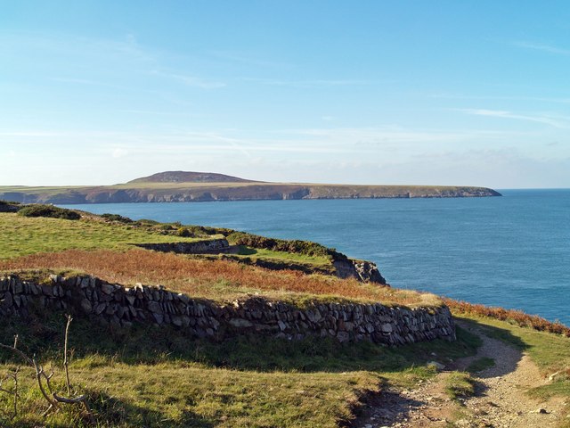
Carn ar Wig is a picturesque beach located in Pembrokeshire, Wales. Known for its stunning views and rugged coastline, the beach is popular among locals and tourists alike. The beach is framed by towering cliffs and rock formations, creating a dramatic backdrop for sunbathers and swimmers.

Carn ar Wig offers a wide expanse of golden sand, perfect for long walks and beachcombing. The beach is also ideal for watersports such as surfing, windsurfing, and paddleboarding, thanks to the consistent waves and breezy conditions. The clear waters are also great for snorkeling and swimming, with plenty of marine life to observe.

Visitors to Carn ar Wig can enjoy facilities such as parking, toilets, and a nearby cafe for refreshments. The beach is easily accessible by car and is within walking distance of the nearby village of St. Davids.

Overall, Carn ar Wig is a hidden gem in Pembrokeshire, offering a tranquil and unspoiled setting for beachgoers to relax and enjoy the natural beauty of the Welsh coastline.

If you have any feedback on the listing, please let us know in the comments section below.

Carn ar Wig Images

Images are sourced within 2km of 51.865803/-5.3159126 or Grid Reference SM7123. Thanks to Geograph Open Source API. All images are credited.

Carnysgubor and The Bungalow, Ramsey Island
Aber Mawr Cliffs & Carnysgubor, Ramsey Island
Aber Mawr, Ramsey Island
Path on Carnysgubor The main route to the third highest point on Ramsey Island (Carnllundain has a subsidiary peak higher than this). The view extends over Aber Mawr to Carnllundain with Skomer Island on the far skyline.
Path on Carnysgubor
The main route to the third highest point on Ramsey Island (Carnllundain has a subsidiary peak higher than this). The view extends over Aber Mawr to Carnllundain with Skomer Island on the far skyline.
Subsidiary peak and cairn on Carnysgubor Carn Llidi and Whitesands Bay are very clear on the mainland. The image also shows the flat north eastern corner of the island where most of its farming takes place.
Subsidiary peak and cairn on Carnysgubor
Carn Llidi and Whitesands Bay are very clear on the mainland. The image also shows the flat north eastern corner of the island where most of its farming takes place.
Aber Mawr Viewed from the south side with Carnysgubor behind it.
Aber Mawr
Viewed from the south side with Carnysgubor behind it.
Porth Lleuog The elements have penetrated well into the cliffs in this cove. On the skyline is the island of Grassholm.
Porth Lleuog
The elements have penetrated well into the cliffs in this cove. On the skyline is the island of Grassholm.
Beach at Aber Mawr, Ramsey Island
Carnysgubor, Ramsey Island From the top of this hill you can see the farmland below, The Bitches dotted towards the top left and the north Pembrokeshire coastline across the water.
Carnysgubor, Ramsey Island
From the top of this hill you can see the farmland below, The Bitches dotted towards the top left and the north Pembrokeshire coastline across the water.
The beach at Porth Lleuog No landing allowed on this steeply shelving white beach.
The beach at Porth Lleuog
No landing allowed on this steeply shelving white beach.
Beach at Aber Mawr, Ramsey Island Described by our guide as 'fragile with frequent landslips', this is the island's longest beach, popular with Atlantic grey seals.
Beach at Aber Mawr, Ramsey Island
Described by our guide as 'fragile with frequent landslips', this is the island's longest beach, popular with Atlantic grey seals.
The beach at Porth Lleuog The blue sign warns that landing is forbidden (but you need to be ashore to read it!)
The beach at Porth Lleuog
The blue sign warns that landing is forbidden (but you need to be ashore to read it!)
View north-eastwards from Carnllundain This is the view from Carnllundain, Ramsey Island's highest point. Red deer are often seen on the higher land below the summit, whilst sheep graze on the lower-lying land on the east side of the island.  In the distance is St David's Head, on the Pembrokeshire mainland.
View north-eastwards from Carnllundain
This is the view from Carnllundain, Ramsey Island's highest point. Red deer are often seen on the higher land below the summit, whilst sheep graze on the lower-lying land on the east side of the island. In the distance is St David's Head, on the Pembrokeshire mainland.
View eastwards from Carnllundain The view from Ramsey Island's highest point looks towards the city of St David's and the Pembrokeshire mainland.
View eastwards from Carnllundain
The view from Ramsey Island's highest point looks towards the city of St David's and the Pembrokeshire mainland.
Porthstinian Porthstinian from Maen Bachau, on the other side of the bay is St Justinian Lifeboat Station.
Porthstinian
Porthstinian from Maen Bachau, on the other side of the bay is St Justinian Lifeboat Station.
Field Boundaries Dry stone walled field boundaries on the Pembrokeshire Coast Path.
Field Boundaries
Dry stone walled field boundaries on the Pembrokeshire Coast Path.
The Bitches The Bitches are a set of rocks and tidal rapid in the Ramsey Sound.
<span class="nowrap"><a title="http://www.the-bitches.co.uk" rel="nofollow ugc noopener" href="http://www.the-bitches.co.uk">Link</a><img style="margin-left:2px;" alt="External link" title="External link - shift click to open in new window" src="https://s1.geograph.org.uk/img/external.png" width="10" height="10"/></span>
The Bitches
The Bitches are a set of rocks and tidal rapid in the Ramsey Sound. LinkExternal link
Ynys Cantwr and Ramsey Island
Show me another place!

Carn ar Wig is located at Grid Ref: SM7123 (Lat: 51.865803, Lng: -5.3159126)

Unitary Authority: Pembrokeshire

Police Authority: Dyfed Powys

What 3 Words

///grins.cheering.motoring. Near St Davids, Pembrokeshire

Related Wikis

Pen Dal-aderyn

Pen Dal-aderyn is the westernmost point of mainland Wales. It is in Pembrokeshire, west of St Davids. It means 'Bird-catching Head' in Welsh. == External... ==

The Bitches

The Bitches (also known as Bitches and Whelps) are a tidal race and set of rocks between Ramsey Island and the west Welsh coastline near St Davids. They...

St Justinian

St Justinian (or St Justinian's or St Justinians; Welsh: Porth Stinan) is a coastal location of indeterminate area in the extreme northwest of Pembrokeshire...

St Justinian's Chapel

St Justinian's Chapel in Pembrokeshire, Wales, is now a roofless shell; the current structure was probably erected in the 16th century on earlier foundations...

Nearby Amenities

Located within 500m of 51.865803,-5.3159126
Source: OS_Opendata_Vectormap_District
Lat/Long: 51.8664289/-5.3148516
Source: OS_Opendata_Vectormap_District
Lat/Long: 51.862069/-5.3198427
Source: OS_Opendata_Vectormap_District
Lat/Long: 51.8622144/-5.3198651
Source: OS_Opendata_Vectormap_District
Lat/Long: 51.862319/-5.3198429
Source: OS_Opendata_Vectormap_District
Lat/Long: 51.8624269/-5.3197939
Source: OS_Opendata_Vectormap_District
Lat/Long: 51.86257/-5.3198188
Source: OS_Opendata_Vectormap_District
Lat/Long: 51.8626977/-5.3198741
Source: OS_Opendata_Vectormap_District
Lat/Long: 51.8628367/-5.3199192
Source: OS_Opendata_Vectormap_District
Lat/Long: 51.8629472/-5.3199386
Source: OS_Opendata_Vectormap_District
Lat/Long: 51.8630521/-5.3199431
Source: OS_Opendata_Vectormap_District
Lat/Long: 51.8632714/-5.3199331
Source: OS_Opendata_Vectormap_District
Lat/Long: 51.863405/-5.3199357
Source: OS_Opendata_Vectormap_District
Lat/Long: 51.8635095/-5.3199307
Source: OS_Opendata_Vectormap_District
Lat/Long: 51.8636153/-5.319906
Source: OS_Opendata_Vectormap_District
Lat/Long: 51.8637183/-5.3198882
Source: OS_Opendata_Vectormap_District
Lat/Long: 51.863721/-5.3199934
Source: OS_Opendata_Vectormap_District
Lat/Long: 51.863731/-5.3200428
Source: OS_Opendata_Vectormap_District
Lat/Long: 51.8637329/-5.3199093
Source: OS_Opendata_Vectormap_District
Lat/Long: 51.8637796/-5.3200569
Source: OS_Opendata_Vectormap_District
Lat/Long: 51.8638338/-5.3200439
Source: OS_Opendata_Vectormap_District
Lat/Long: 51.8639453/-5.3200464
Source: OS_Opendata_Vectormap_District
Lat/Long: 51.8640252/-5.3200423
Source: OS_Opendata_Vectormap_District
Lat/Long: 51.8641175/-5.3200215
Source: OS_Opendata_Vectormap_District
Lat/Long: 51.8641734/-5.3199993
Source: OS_Opendata_Vectormap_District
Lat/Long: 51.8642413/-5.3199471
Source: OS_Opendata_Vectormap_District
Lat/Long: 51.864277/-5.3198549
Source: OS_Opendata_Vectormap_District
Lat/Long: 51.8643896/-5.3197989
Source: OS_Opendata_Vectormap_District
Lat/Long: 51.8645792/-5.3197551
Source: OS_Opendata_Vectormap_District
Lat/Long: 51.8646801/-5.3197536
Source: OS_Opendata_Vectormap_District
Lat/Long: 51.8647867/-5.3197433
Source: OS_Opendata_Vectormap_District
Lat/Long: 51.8649582/-5.3196874
Source: OS_Opendata_Vectormap_District
Lat/Long: 51.8650348/-5.3196649
Source: OS_Opendata_Vectormap_District
Lat/Long: 51.8652401/-5.3196265
Source: OS_Opendata_Vectormap_District
Lat/Long: 51.8654807/-5.3195131
Source: OS_Opendata_Vectormap_District
Lat/Long: 51.8655214/-5.3194577
Source: OS_Opendata_Vectormap_District
Lat/Long: 51.8655443/-5.3193685
Source: OS_Opendata_Vectormap_District
Lat/Long: 51.8655685/-5.3159769
Source: OS_Opendata_Vectormap_District
Lat/Long: 51.8655768/-5.3158777
Source: OS_Opendata_Vectormap_District
Lat/Long: 51.8656066/-5.3158269
Source: OS_Opendata_Vectormap_District
Lat/Long: 51.8656387/-5.319176
Source: OS_Opendata_Vectormap_District
Lat/Long: 51.8656361/-5.3157698
Source: OS_Opendata_Vectormap_District
Lat/Long: 51.8656471/-5.3161418
Source: OS_Opendata_Vectormap_District
Lat/Long: 51.8656539/-5.3156624
Source: OS_Opendata_Vectormap_District
Lat/Long: 51.8656621/-5.3190858
Source: OS_Opendata_Vectormap_District
Lat/Long: 51.8656768/-5.3155984
Source: OS_Opendata_Vectormap_District
Lat/Long: 51.8656952/-5.3161863
Source: OS_Opendata_Vectormap_District
Lat/Long: 51.8657096/-5.3190145
Source: OS_Opendata_Vectormap_District
Lat/Long: 51.8657619/-5.315537
Source: OS_Opendata_Vectormap_District
Lat/Long: 51.8658166/-5.3155034
Source: OS_Opendata_Vectormap_District
Lat/Long: 51.8658701/-5.3162531
Source: OS_Opendata_Vectormap_District
Lat/Long: 51.8658725/-5.318855
Source: OS_Opendata_Vectormap_District
Lat/Long: 51.8659181/-5.3162675
Source: OS_Opendata_Vectormap_District
Lat/Long: 51.8659252/-5.3154154
Source: OS_Opendata_Vectormap_District
Lat/Long: 51.8659723/-5.3186484
Source: OS_Opendata_Vectormap_District
Lat/Long: 51.8659781/-5.3185337
Source: OS_Opendata_Vectormap_District
Lat/Long: 51.8659844/-5.3184546
Source: OS_Opendata_Vectormap_District
Lat/Long: 51.8660139/-5.3153661
Source: OS_Opendata_Vectormap_District
Lat/Long: 51.8660223/-5.3183308
Source: OS_Opendata_Vectormap_District
Lat/Long: 51.8660537/-5.3163392
Source: OS_Opendata_Vectormap_District
Lat/Long: 51.8660986/-5.3153287
Source: OS_Opendata_Vectormap_District
Lat/Long: 51.8661068/-5.3181595
Source: OS_Opendata_Vectormap_District
Lat/Long: 51.8661351/-5.3164722
Source: OS_Opendata_Vectormap_District
Lat/Long: 51.866144/-5.3180511
Source: OS_Opendata_Vectormap_District
Lat/Long: 51.8661641/-5.3165925
Source: OS_Opendata_Vectormap_District
Lat/Long: 51.8661804/-5.3175572
Source: OS_Opendata_Vectormap_District
Lat/Long: 51.866183/-5.3152564
Source: OS_Opendata_Vectormap_District
Lat/Long: 51.8661861/-5.3176795
Source: OS_Opendata_Vectormap_District
Lat/Long: 51.866187/-5.317833
Source: OS_Opendata_Vectormap_District
Lat/Long: 51.8661879/-5.3166766
Source: OS_Opendata_Vectormap_District
Lat/Long: 51.8662112/-5.3173418
Source: OS_Opendata_Vectormap_District
Lat/Long: 51.8662348/-5.3172545
Source: OS_Opendata_Vectormap_District
Lat/Long: 51.8662415/-5.3151694
Source: OS_Opendata_Vectormap_District
Lat/Long: 51.8662499/-5.316767
Source: OS_Opendata_Vectormap_District
Lat/Long: 51.8662927/-5.31704
Source: OS_Opendata_Vectormap_District
Lat/Long: 51.8663017/-5.3168586
Source: OS_Opendata_Vectormap_District
Lat/Long: 51.8663095/-5.3169115
Source: OS_Opendata_Vectormap_District
Lat/Long: 51.8663826/-5.3148383
Source: OS_Opendata_Vectormap_District
Lat/Long: 51.8664515/-5.315061
Source: OS_Opendata_Vectormap_District
Lat/Long: 51.8665432/-5.3150352
Source: OS_Opendata_Vectormap_District
Lat/Long: 51.8666473/-5.3148188
Source: OS_Opendata_Vectormap_District
Lat/Long: 51.8666513/-5.3151517
Source: OS_Opendata_Vectormap_District
Lat/Long: 51.8667162/-5.3151847
Source: OS_Opendata_Vectormap_District
Lat/Long: 51.8668737/-5.3151849
Source: OS_Opendata_Vectormap_District
Lat/Long: 51.8670387/-5.3151263
Source: OS_Opendata_Vectormap_District
Lat/Long: 51.8671139/-5.3150096
Source: OS_Opendata_Vectormap_District
Lat/Long: 51.8671787/-5.3148646
Source: OS_Opendata_Vectormap_District
Lat/Long: 51.8672146/-5.3148278
Source: OS_Opendata_Vectormap_District
Lat/Long: 51.8672683/-5.314829
Source: OS_Opendata_Vectormap_District
Lat/Long: 51.8673084/-5.3148567
Source: OS_Opendata_Vectormap_District
Lat/Long: 51.8673437/-5.3149039
Source: OS_Opendata_Vectormap_District
Lat/Long: 51.8674182/-5.31486
Source: OS_Opendata_Vectormap_District
Lat/Long: 51.867566/-5.3147245
Source: OS_Opendata_Vectormap_District
Lat/Long: 51.8676455/-5.3146384
Source: OS_Opendata_Vectormap_District
Lat/Long: 51.867737/-5.3145439
Source: OS_Opendata_Vectormap_District
Lat/Long: 51.8678832/-5.3143861
Source: OS_Opendata_Vectormap_District
Lat/Long: 51.8679508/-5.3144698
Source: OS_Opendata_Vectormap_District
Lat/Long: 51.8679012/-5.3145958
Source: OS_Opendata_Vectormap_District
Lat/Long: 51.8679821/-5.31467
Source: OS_Opendata_Vectormap_District
Lat/Long: 51.8680222/-5.3146866
Source: OS_Opendata_Vectormap_District
Lat/Long: 51.8680936/-5.3147802
Source: OS_Opendata_Vectormap_District
Lat/Long: 51.8681933/-5.3147953
Source: OS_Opendata_Vectormap_District
Lat/Long: 51.8682991/-5.3147487
Source: OS_Opendata_Vectormap_District
Lat/Long: 51.8684555/-5.31466
Source: OS_Opendata_Vectormap_District
Lat/Long: 51.868589/-5.3145669
Source: OS_Opendata_Vectormap_District
Lat/Long: 51.8686624/-5.3145315
Source: OS_Opendata_Vectormap_District
Lat/Long: 51.8687705/-5.3144636
Source: OS_Opendata_Vectormap_District
Lat/Long: 51.8688697/-5.3143769
Source: OS_Opendata_Vectormap_District
Lat/Long: 51.869007/-5.3142182
Source: OS_Opendata_Vectormap_District
Lat/Long: 51.8691037/-5.3140697
Source: OS_Opendata_Vectormap_District
Lat/Long: 51.8691804/-5.3124901
Source: OS_Opendata_Vectormap_District
Lat/Long: 51.8691439/-5.3117079
Source: OS_Opendata_Vectormap_District
Lat/Long: 51.8691336/-5.3117686
Source: OS_Opendata_Vectormap_District
Lat/Long: 51.8691569/-5.3139524
Source: OS_Opendata_Vectormap_District
Lat/Long: 51.8691851/-5.3125412
Source: OS_Opendata_Vectormap_District
Lat/Long: 51.8692109/-5.31241
Source: OS_Opendata_Vectormap_District
Lat/Long: 51.8692105/-5.3113133
Source: OS_Opendata_Vectormap_District
Lat/Long: 51.8692326/-5.3113535
Source: OS_Opendata_Vectormap_District
Lat/Long: 51.8691958/-5.3118867
Source: OS_Opendata_Vectormap_District
Lat/Long: 51.8692194/-5.3125555
Source: OS_Opendata_Vectormap_District
Lat/Long: 51.8692301/-5.3137105
Source: OS_Opendata_Vectormap_District
Lat/Long: 51.8691784/-5.3116373
Source: OS_Opendata_Vectormap_District
Lat/Long: 51.8693975/-5.312179
Source: OS_Opendata_Vectormap_District
Lat/Long: 51.8692886/-5.3134928
Source: OS_Opendata_Vectormap_District
Lat/Long: 51.8694116/-5.3121072
Source: OS_Opendata_Vectormap_District
Lat/Long: 51.8693448/-5.312014
Source: OS_Opendata_Vectormap_District
Lat/Long: 51.8693478/-5.312451
Source: OS_Opendata_Vectormap_District
Lat/Long: 51.86941/-5.3120189
Source: OS_Opendata_Vectormap_District
Lat/Long: 51.869372/-5.3120562
Source: OS_Opendata_Vectormap_District
Lat/Long: 51.8693433/-5.313311
Source: OS_Opendata_Vectormap_District
Lat/Long: 51.8693884/-5.3124
Source: OS_Opendata_Vectormap_District
Lat/Long: 51.8694497/-5.312426
Source: OS_Opendata_Vectormap_District
Lat/Long: 51.8694016/-5.3131714
Source: OS_Opendata_Vectormap_District
Lat/Long: 51.8694194/-5.3125646
Source: OS_Opendata_Vectormap_District
Lat/Long: 51.8692669/-5.313065
Source: OS_Opendata_Vectormap_District
Lat/Long: 51.8694167/-5.3126221
The data included in this document is from www.openstreetmap.org. The data is made available under ODbL.

Have you been to Carn ar Wig?

Leave your review of Carn ar Wig below (or comments, questions and feedback).