Tràigh na Clibhe

Beach in Ross-shire

Scotland

Tràigh na Clibhe

Lazy Beds at Tràigh na Beirigh Ridges formed by hand digging of fields.  These one are unusual in that some of the ridges are lined with small stones.
Lazy Beds at Tràigh na Beirigh Credit: Sandy Gerrard

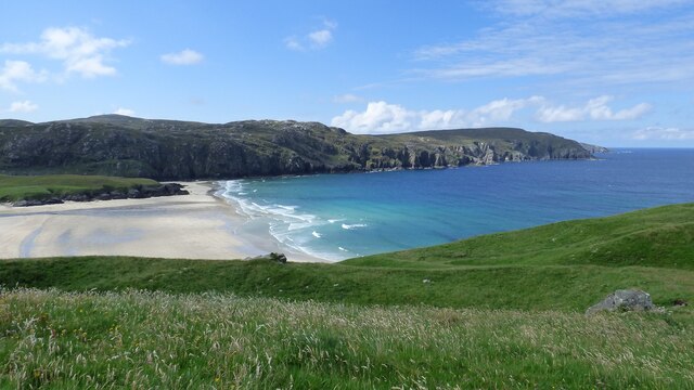
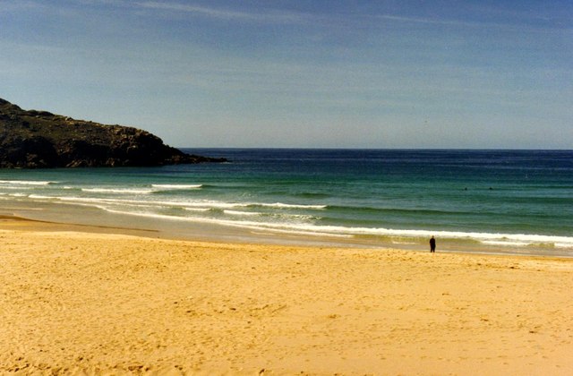
Tràigh na Clibhe, located in Ross-shire, Scotland, is a picturesque beach that offers stunning natural beauty and a tranquil atmosphere. Situated on the northwest coast of Scotland, it is known for its sparkling white sands, crystal-clear turquoise waters, and breathtaking views of the surrounding landscape.

The beach stretches for approximately 2 miles and is backed by rolling sand dunes, creating a scenic backdrop for visitors to enjoy. Tràigh na Clibhe is also surrounded by rugged cliffs, adding to its dramatic charm. The beach is relatively secluded, making it an ideal spot for those seeking peace and relaxation.

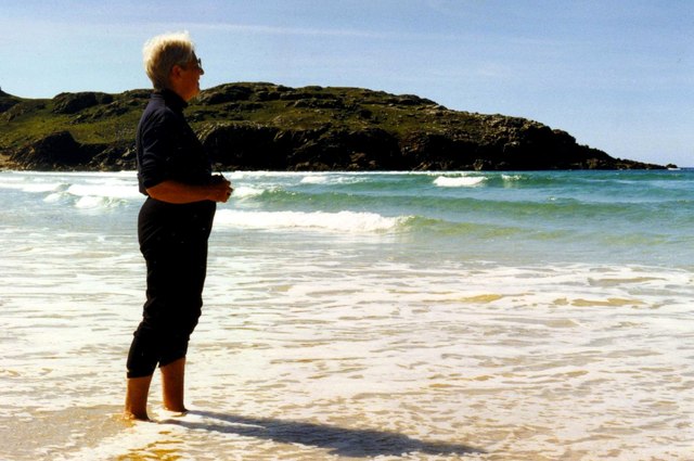
The pristine sands of Tràigh na Clibhe are perfect for long walks, picnics, and sunbathing. The shallow waters are safe for swimming and provide a refreshing escape during the summer months. The beach is also a haven for wildlife enthusiasts, as it is home to a rich variety of bird species, including oystercatchers and sandpipers.

Tràigh na Clibhe offers ample parking facilities and has a small café nearby, providing refreshments and snacks for visitors. It is a popular destination for locals and tourists alike, attracting those who appreciate the unspoiled beauty of Scotland's coastline.

Overall, Tràigh na Clibhe is a hidden gem in Ross-shire, offering a peaceful retreat for nature lovers and beach enthusiasts. With its pristine sands, stunning views, and abundant wildlife, it is a must-visit destination for those exploring the Scottish Highlands.

If you have any feedback on the listing, please let us know in the comments section below.

Tràigh na Clibhe Images

Images are sourced within 2km of 58.220392/-6.968677 or Grid Reference NB0836. Thanks to Geograph Open Source API. All images are credited.

Lazy Beds at Tràigh na Beirigh Ridges formed by hand digging of fields.  These one are unusual in that some of the ridges are lined with small stones.
Lazy Beds at Tràigh na Beirigh
Ridges formed by hand digging of fields. These one are unusual in that some of the ridges are lined with small stones.
Gob Geòdha nam Bradan
Sheepfold at Tobha Mòr
Sheepfold and boundary wall near Tobha Mòr
Rocky surface at Eala Sheadha
Eastern side of the Eala Sheadha Headland
Berie Sands Caravan Park Busy site at Traigh na Beirigh with many caravans parked on the machair above the extensive sands.
Berie Sands Caravan Park
Busy site at Traigh na Beirigh with many caravans parked on the machair above the extensive sands.
Tràigh na Beirigh In the 1960's this was a deserted beach.  Now it has to be shared with caravanners.
Tràigh na Beirigh
In the 1960's this was a deserted beach. Now it has to be shared with caravanners.
Sunrise, Gridig
Sunrise, Gridig
Tràigh na Beirigh and Pabaigh Mòr
Traigh na Beirigh beach Lewis Looking out from the beach just in front of the Caravan site towards the headland at Kneep on the left and Pabaigh Mor on the right.
Traigh na Beirigh beach Lewis
Looking out from the beach just in front of the Caravan site towards the headland at Kneep on the left and Pabaigh Mor on the right.
Tràigh na Clibhe on the Isle of Lewis This beautiful north-facing beach, Tràigh na Clibhe, is popular with surfers (two are just visible beyond the lone figure). It is protected on both sides by 50 foot high cliffs (not in view here, but see <a title="https://www.geograph.org.uk/photo/1618866" href="https://www.geograph.org.uk/photo/1618866">Link</a> )
Tràigh na Clibhe on the Isle of Lewis
This beautiful north-facing beach, Tràigh na Clibhe, is popular with surfers (two are just visible beyond the lone figure). It is protected on both sides by 50 foot high cliffs (not in view here, but see Link )
Tràigh na Clibhe On the skyline is the low headland which marks the left edge of Tràigh na Clibhe beach. This north-facing beach is also protected on both sides by 50 foot high cliffs (not in view here, but see <a title="https://www.geograph.org.uk/photo/1618866" href="https://www.geograph.org.uk/photo/1618866">Link</a> ). In the hinterland is the village of Cliobh (Cliff) to the south and the town of Bhaltos (Valtos) to the east, providing several alternative names for this popular beach.
Tràigh na Clibhe
On the skyline is the low headland which marks the left edge of Tràigh na Clibhe beach. This north-facing beach is also protected on both sides by 50 foot high cliffs (not in view here, but see Link ). In the hinterland is the village of Cliobh (Cliff) to the south and the town of Bhaltos (Valtos) to the east, providing several alternative names for this popular beach.
Miavaig / Miabhaig Village Crofting and fishing village on the shore of Loch Miabhaig.
Miavaig / Miabhaig Village
Crofting and fishing village on the shore of Loch Miabhaig.
Traigh na Clibhe North-west facing bay, backed by sand dunes, north of Cliobh.
Traigh na Clibhe
North-west facing bay, backed by sand dunes, north of Cliobh.
Bhaltos / Valtos Community of crofts, fishermen's houses and holiday homes on Pabbay Sound / Caolas Phabaigh.
Bhaltos / Valtos
Community of crofts, fishermen's houses and holiday homes on Pabbay Sound / Caolas Phabaigh.
Valtos Pier Sheltering the small harbour of Valtos / Bhaltos on Pabbay Sound / Caolas Phabaigh. The island of Pabaigh Mor / Big Pabbay is in the background.
Valtos Pier
Sheltering the small harbour of Valtos / Bhaltos on Pabbay Sound / Caolas Phabaigh. The island of Pabaigh Mor / Big Pabbay is in the background.
Machair Above Berie Sands Fertile grassland with summer flowers in bloom - with view across Traigh na Beirigh.
Machair Above Berie Sands
Fertile grassland with summer flowers in bloom - with view across Traigh na Beirigh.
Show me another place!

Tràigh na Clibhe is located at Grid Ref: NB0836 (Lat: 58.220392, Lng: -6.968677)

Unitary Authority: Na h-Eileanan an Iar

Police Authority: Highlands and Islands

What 3 Words

///splashes.financial.artichoke. Near Carloway, Na h-Eileanan Siar

Related Wikis

Cliff, Lewis

Cliff (Scottish Gaelic: Cliobh) is a small settlement on the Isle of Lewis, in the Outer Hebrides, Scotland. Cliff is within the parish of Uig. The settlement...

Kneep

Kneep (Scottish Gaelic: Cnìp) is a village on the Isle of Lewis, in the Outer Hebrides, Scotland. Kneep is within the parish of Uig.Various archaeological...

Loch na Berie

Loch Na Berie is a broch in the Outer Hebrides of Scotland, located approximately 400 yards from the shore, and is thought to have been located on an island...

Pabaigh Mòr

Pabay Mòr or Pabaigh Mòr is an uninhabited island in the Outer Hebrides of Scotland. == History == The island's name comes from papey, an Old Norse name...

Related Videos

THIS CLIFF IS 40 METERS HIGH! ft. A Random German

Shout out to the random german guy Subscribe, or you will fall of the cliff! Btw Subscribe to Don't Subscribe.

Reef beach 30th May

4K drone footage of Reef beach, Uig, Western Isles captured on my DJI Mini 2 drone with a ND64 filter.

Kneep, Isle of Lewis.

Kneep (Scottish Gaelic: Cnìp) is a village on the Isle of Lewis, in the Outer Hebrides, Scotland. Kneep is within the parish of Uig.

Nearby Amenities

Located within 500m of 58.220392,-6.968677
Passing Place
Lat/Long: 58.219043/-6.9651337
Passing Place
Lat/Long: 58.2194395/-6.9634875
Passing Place
Lat/Long: 58.2200761/-6.9624563
Passing Place
Lat/Long: 58.2209038/-6.9621875
Cliff
Naptan AtcoCode: 6010731613
Naptan Bearing: N
Naptan BusStopType: CUS
Naptan CommonName: Cliff
Naptan Indicator: Village
Naptan Landmark: Road junction
Naptan NaptanCode: 94723923
Naptan Street: Unclassified road
Naptan Verified: no
Source: naptan_import
Lat/Long: 58.21607/-6.9689558
Parking
Lat/Long: 58.2200524/-6.966096
Turning Circle
Lat/Long: 58.2178641/-6.971356
Tourism: picnic_site
Lat/Long: 58.221916/-6.9621875
Passing Place
Lat/Long: 58.2195754/-6.9624377
Power: pole
Lat/Long: 58.2193698/-6.9608212
Power: pole
Lat/Long: 58.2189658/-6.9620249
Power: pole
Lat/Long: 58.2188876/-6.9631414
Power: pole
Lat/Long: 58.2188018/-6.9642236
Power: pole
Lat/Long: 58.2183352/-6.9650069
Power: pole
Lat/Long: 58.2177937/-6.9658868
Power: pole
Lat/Long: 58.2171774/-6.966915
Power: pole
Lat/Long: 58.2165963/-6.9678954
Power: pole
Lat/Long: 58.2160594/-6.9681157
Power: pole
Lat/Long: 58.2177475/-6.9712124
Power: pole
Lat/Long: 58.2172623/-6.9710762
Power: pole
Lat/Long: 58.2168012/-6.9709196
Power: pole
Lat/Long: 58.2195139/-6.9632912
Power: pole
Lat/Long: 58.2194702/-6.9618173
Power: pole
Lat/Long: 58.219746/-6.9612907
Power: pole
Lat/Long: 58.2199456/-6.9609032
Passing Place
Lat/Long: 58.2171561/-6.9682424
Power: pole
Lat/Long: 58.2162484/-6.970747
Passing Place
Lat/Long: 58.2223166/-6.9614368
The data included in this document is from www.openstreetmap.org. The data is made available under ODbL.

Have you been to Tràigh na Clibhe?

Leave your review of Tràigh na Clibhe below (or comments, questions and feedback).