Batheaston

Settlement in Somerset

England

Batheaston

Milestone by A4, London Road East; 100m West of Lower Shockerwick Lodge The Milestone is located on grass verge by path on the North of the road.  Parish of Bathford (Bath and North East Somerset District). Metal plate attached to stone post, Bath incised iron plate design, erected by the Bath turnpike trust in the 21st Century. An earlier photograph can be found here: <a title="https://www.geograph.org.uk/photo/6049925" href="https://www.geograph.org.uk/photo/6049925">Link</a> 

Inscription reads:-  
To / BATH / 4 

Milestone Society National ID: SO_BACH04
Milestone by A4, London Road East; 100m West of Lower Shockerwick Lodge Credit: Roadside Relics

Batheaston is a picturesque village located in Somerset, England. Situated on the eastern outskirts of the historic city of Bath, it forms part of the Bath and North East Somerset district. With a population of around 2,500 residents, Batheaston offers a peaceful and welcoming environment.

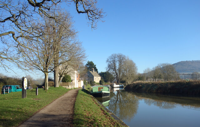
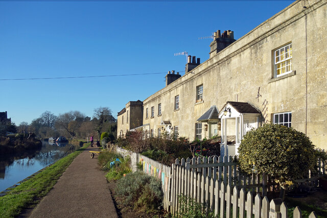
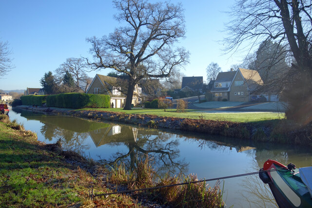
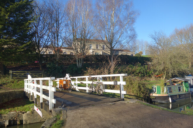
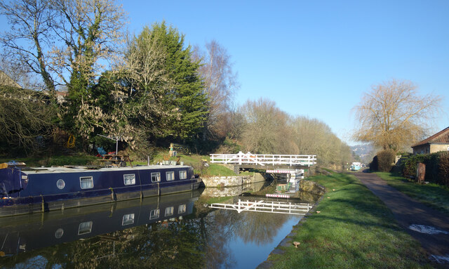
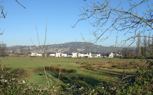
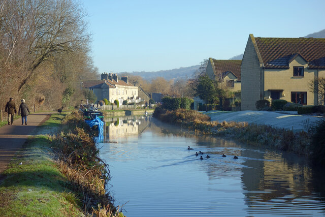
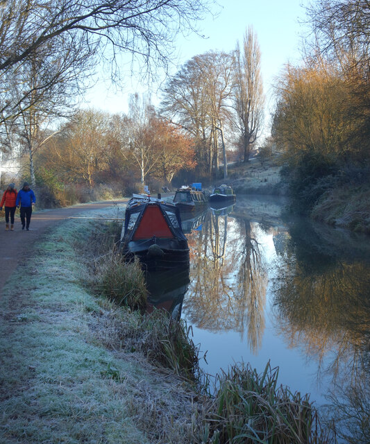
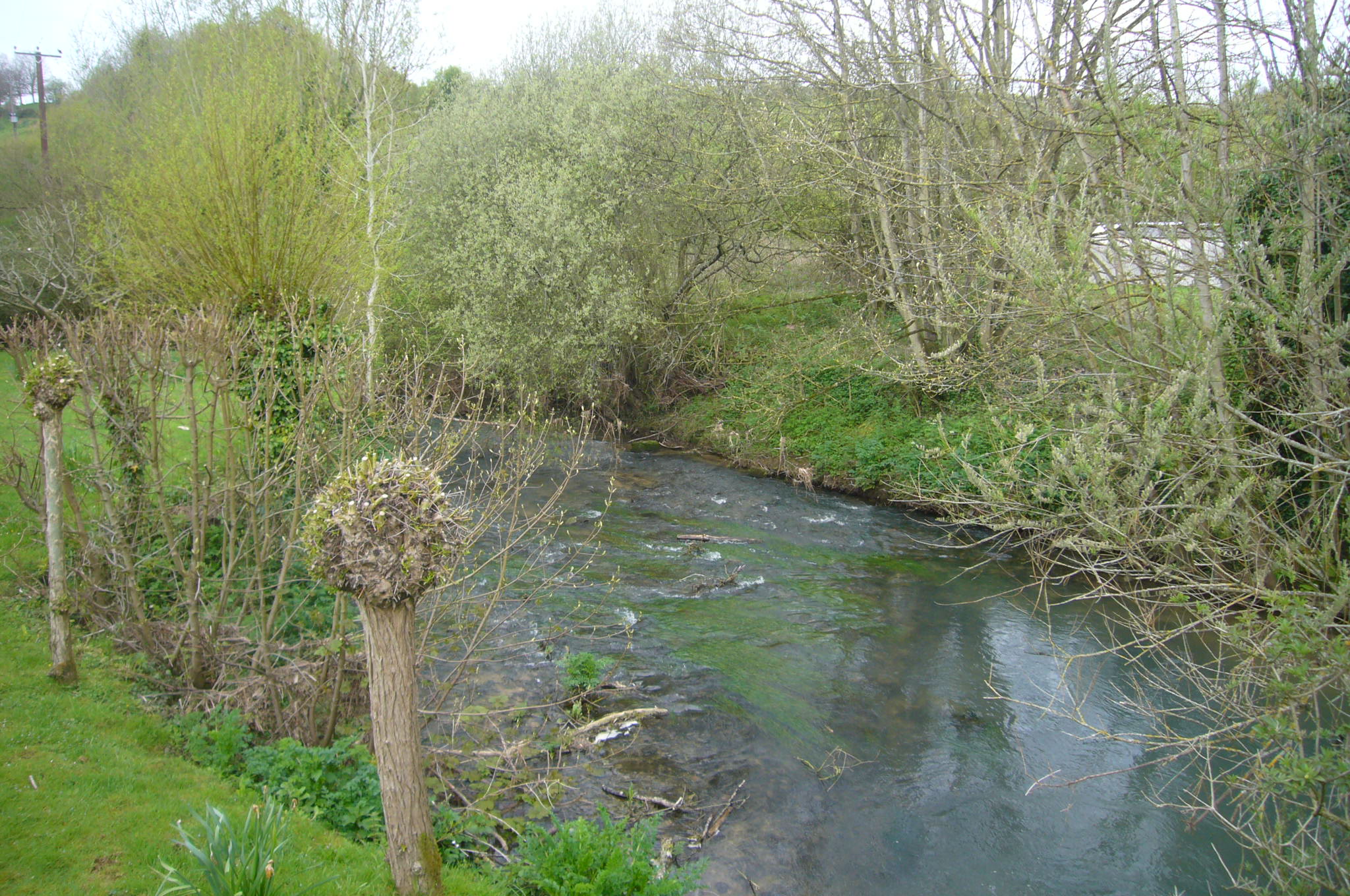
The village is known for its stunning natural beauty, surrounded by rolling hills and lush countryside. It is situated on the banks of the River Avon, providing residents with scenic views and opportunities for leisurely walks along the riverbank.

Batheaston has a rich history dating back to Roman times, evident by the remains of a Roman villa that were discovered in the area. The village also boasts several Grade II listed buildings, such as St. John the Baptist Church, which dates back to the 12th century.

Despite its rural charm, Batheaston benefits from excellent transport links. The A4 road passes through the village, connecting it to Bath and Bristol. Additionally, regular bus services run to and from Bath, making it easily accessible for commuters and visitors alike.

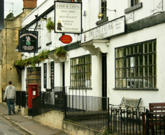
The village offers a range of amenities, including a primary school, a post office, a village store, and several pubs and restaurants. Residents also have access to a community center, sports facilities, and a playground. The nearby Bath provides further opportunities for shopping, dining, and cultural activities.

Overall, Batheaston is a delightful village that combines natural beauty, historical significance, and convenient amenities, making it an attractive place to live or visit in Somerset.

If you have any feedback on the listing, please let us know in the comments section below.

Batheaston Images

Images are sourced within 2km of 51.405174/-2.316801 or Grid Reference ST7867. Thanks to Geograph Open Source API. All images are credited.

Milestone by A4, London Road East; 100m West of Lower Shockerwick Lodge The Milestone is located on grass verge by path on the North of the road.  Parish of Bathford (Bath and North East Somerset District). Metal plate attached to stone post, Bath incised iron plate design, erected by the Bath turnpike trust in the 21st Century. An earlier photograph can be found here: <a title="https://www.geograph.org.uk/photo/6049925" href="https://www.geograph.org.uk/photo/6049925">Link</a> 

Inscription reads:-  
To / BATH / 4 

Milestone Society National ID: SO_BACH04
Milestone by A4, London Road East; 100m West of Lower Shockerwick Lodge
The Milestone is located on grass verge by path on the North of the road.  Parish of Bathford (Bath and North East Somerset District). Metal plate attached to stone post, Bath incised iron plate design, erected by the Bath turnpike trust in the 21st Century. An earlier photograph can be found here: Link  Inscription reads:- To / BATH / 4 Milestone Society National ID: SO_BACH04
By Brook runs through the field
Old Milestone by the A4, London Road East, Bathford parish Metal plate attached to stone post by the A4, in parish of BATHFORD (BATH AND NORTH EAST SOMERSET District), London Road East; 100m West of Lower Shockerwick Lodge, on grass verge by path, on North side of road. Bath incised iron plate, erected by the Bath turnpike trust in the 21st century. 

Inscription reads:-
To
BATH
4 

Milestone Society National ID: SO_BACH04.
Old Milestone by the A4, London Road East, Bathford parish
Metal plate attached to stone post by the A4, in parish of BATHFORD (BATH AND NORTH EAST SOMERSET District), London Road East; 100m West of Lower Shockerwick Lodge, on grass verge by path, on North side of road. Bath incised iron plate, erected by the Bath turnpike trust in the 21st century. Inscription reads:- To BATH 4 Milestone Society National ID: SO_BACH04.
A4 near Box Bridge Taken from Lower Shockerwick Lodge, looking west towards Bath.
A4 near Box Bridge
Taken from Lower Shockerwick Lodge, looking west towards Bath.
Fingerpost, Bathford On the junction of Bath Hill with Ostlings Lane, and Bathford Road, A363. 
There is an older image (see <a title="https://www.geograph.org.uk/photo/6044960" href="https://www.geograph.org.uk/photo/6044960">Link</a> ) before recent renovation and painting.
Pyramid finial - 3 arms Somerset SCC pyramid finial, in the parish of Bathford (Bath and North East Somerset District), on grass triangle, by bench and planter.

Milestone Society National ID: SO_ST7866
Fingerpost, Bathford
On the junction of Bath Hill with Ostlings Lane, and Bathford Road, A363. There is an older image (see Link ) before recent renovation and painting. Pyramid finial - 3 arms Somerset SCC pyramid finial, in the parish of Bathford (Bath and North East Somerset District), on grass triangle, by bench and planter. Milestone Society National ID: SO_ST7866
Bannerdown Trig Point Flush Bracket S3220
Cave entrance, Brown's Folly Nature Reserve No great depth to this cave
Cave entrance, Brown's Folly Nature Reserve
No great depth to this cave
Footpath, Bathford Hill A clearing in Brown's Folly Nature Reserve, the folly itself on the hilltop. The Reserve is a Site of Special Scientific Interest.
Footpath, Bathford Hill
A clearing in Brown's Folly Nature Reserve, the folly itself on the hilltop. The Reserve is a Site of Special Scientific Interest.
View downhill from Browne's Folly Nature Reserve
Clearing on Bathford Hill Popular spot for a stroll and for the extensive views
Clearing on Bathford Hill
Popular spot for a stroll and for the extensive views
Kennet & Avon Canal at Bathampton
Canal Terrace, Bathampton A terrace of early 19th century canalside houses.
Canal Terrace, Bathampton
A terrace of early 19th century canalside houses.
Kennet Park, Bathampton Houses near the Kennet & Avon Canal.
Kennet Park, Bathampton
Houses near the Kennet & Avon Canal.
Bikes on the Bridge Bathampton Swing Bridge over the Kennet & Avon Canal with Holcombe Villa in the background.
Bikes on the Bridge
Bathampton Swing Bridge over the Kennet & Avon Canal with Holcombe Villa in the background.
K&A Canal near Bathampton At Bathampton Swing Bridge.
K&A Canal near Bathampton
At Bathampton Swing Bridge.
Avon Valley near Bathampton A view across the valley towards Bathford. The Avon is on the other side of the nearer buildings.
Avon Valley near Bathampton
A view across the valley towards Bathford. The Avon is on the other side of the nearer buildings.
The Canal at Bathampton The Kennet & Avon Canal on a wintry morning.
The Canal at Bathampton
The Kennet & Avon Canal on a wintry morning.
Frosty Morning by the Canal
Show me another place!

Batheaston is located at Grid Ref: ST7867 (Lat: 51.405174, Lng: -2.316801)

Unitary Authority: Bath and North East Somerset

Police Authority: Avon and Somerset

What 3 Words

///gone.intend.rails. Near Bathford, Somerset

Nearby Locations

Batheaston

Related Wikis

Batheaston

Batheaston is a village and civil parish 2 miles (3.2 km) east of the English city of Bath, on the north bank of the River Avon. The parish had a population...

Church of St John The Baptist, Batheaston

The Church of St John the Baptist in Northend, Batheaston within the English county of Somerset was built in the 12th century and remodelled in the 15th...

Bybrook River

The Bybrook, also known as the By Brook, is a small river in England. It is a tributary of the Bristol Avon and is some 12 miles (19 km) long. Its sources...

Bathampton Toll Bridge

Bathampton Toll Bridge is an arch bridge in England, carrying a minor road across the River Avon near Bathampton, to the east of Bath. It is a Grade II...

Nearby Amenities

Located within 500m of 51.405174,-2.316801
Mini Roundabout
Fiveways
Lat/Long: 51.4052172/-2.3167634
Batheaston
Place: village
Postal Code: BA1 7
Website: https://batheaston.org/
Wikidata: Q2083912
Wikipedia: en:Batheaston
Lat/Long: 51.4053125/-2.3167101
Mini Roundabout
Direction: clockwise
Lat/Long: 51.4065857/-2.3106369
Post Box
Collection Times: Mo-Fr 09:00, Sa 07:00
Mapillary: 1044969989768235
Post Box Mounting: stone_wall
Post Box Type: wall
Ref: BA1 176D
Royal Cypher: EIIR
Royal Cypher Wikidata: Q33102113
Survey Date: 2022-04-18
Lat/Long: 51.4036607/-2.3117485
Post Box
Post Box Type: pillar
Royal Cypher: EIIR
Royal Cypher Wikidata: Q33102113
Lat/Long: 51.4086734/-2.3160429
Turning Circle
Source: bing
Lat/Long: 51.4038741/-2.3232032
Crossing
Button Operated: yes
Crossing: traffic_signals
Crossing Ref: pelican
Tactile Paving: yes
Traffic Signals Sound: no
Traffic Signals Vibration: yes
Lat/Long: 51.4053055/-2.317141
Crossing
Button Operated: yes
Crossing: traffic_signals
Crossing Ref: pelican
Tactile Paving: yes
Traffic Signals Sound: no
Traffic Signals Vibration: yes
Lat/Long: 51.405215/-2.3171097
Crossing
Button Operated: yes
Crossing: traffic_signals
Crossing Island: no
Crossing Ref: pelican
Tactile Paving: yes
Traffic Signals Sound: yes
Traffic Signals Vibration: no
Lat/Long: 51.4052291/-2.3220596
Maurdens News
Addr Housenumber: 260
Addr Postcode: BA1 7RA
Addr Street: High Street
Fhrs Id: 203981
Opening Hours: Mo-Fr 05:00-17:00; Sa 04:00-12:00; Su 04:00-10:30
Shop: newsagent
Lat/Long: 51.4053035/-2.3214102
Barrier: kissing_gate
Lat/Long: 51.4071681/-2.3221199
Power: tower
Lat/Long: 51.4016636/-2.3147769
Bus Stop
High Street
Bench: no
Bus: yes
Naptan AtcoCode: 0180BAC30544
Naptan Bearing: NE
Naptan CommonName: High Street
Naptan Crossing: Avondale Place
Naptan NaptanCode: bthmdmd
Naptan PlusbusZoneRef: BATHSPA
Naptan Street: High Street
Naptan Verified: no
Public Transport: platform
Shelter: no
Source: naptan_import
Tactile Paving: no
Lat/Long: 51.4049916/-2.3228001
Bus Stop
Stambridge
Bench: yes
Bin: yes
Bus: yes
Lit: yes
Naptan AtcoCode: 0180BAC30545
Naptan Bearing: N
Naptan CommonName: Stambridge
Naptan Crossing: London Road East
Naptan NaptanCode: bthmdtj
Naptan PlusbusZoneRef: BATHSPA
Naptan Street: Coalpit Road
Naptan Verified: no
Public Transport: platform
Shelter: yes
Source: naptan_import
Tactile Paving: yes
Lat/Long: 51.4055608/-2.3169177
Bus Stop
Avon Court
Bus: yes
Naptan AtcoCode: 0180BAC30546
Naptan Bearing: NE
Naptan CommonName: Avon Court
Naptan Crossing: Avon Court
Naptan NaptanCode: bthmdpw
Naptan PlusbusZoneRef: BATHSPA
Naptan Street: Coalpit Road
Naptan Verified: no
Public Transport: platform
Source: naptan_import
Lat/Long: 51.4076868/-2.3170968
Bus Stop
Avon Court
Bus: yes
Naptan AtcoCode: 0180BAC30547
Naptan Bearing: S
Naptan CommonName: Avon Court
Naptan NaptanCode: bthmdtd
Naptan PlusbusZoneRef: BATHSPA
Naptan Street: Coalpit Road
Naptan Verified: no
Public Transport: platform
Source: naptan_import
Lat/Long: 51.407762/-2.3168861
Bus Stop
Catherine Way
Bus: yes
Naptan AtcoCode: 0180BAC30548
Naptan Bearing: NW
Naptan CommonName: Catherine Way
Naptan NaptanCode: bthmdtm
Naptan PlusbusZoneRef: BATHSPA
Naptan Street: Catherine Way
Naptan Verified: no
Public Transport: platform
Source: naptan_import
Lat/Long: 51.4096375/-2.3172972
Bus Stop
Catherine Way
Bus: yes
Naptan AtcoCode: 0180BAC30549
Naptan Bearing: SE
Naptan CommonName: Catherine Way
Naptan NaptanCode: bthmdtp
Naptan PlusbusZoneRef: BATHSPA
Naptan Street: Catherine Way
Naptan Verified: no
Public Transport: platform
Source: naptan_import
Lat/Long: 51.4093782/-2.3167491
Bus Stop
Stambridge
Bench: yes
Bin: yes
Bus: yes
Lit: yes
Naptan AtcoCode: 0180BAC30552
Naptan Bearing: SE
Naptan CommonName: Stambridge
Naptan Crossing: Fosse Lane
Naptan NaptanCode: bthmdtw
Naptan PlusbusZoneRef: BATHSPA
Naptan Street: London Road East
Naptan Verified: no
Public Transport: platform
Shelter: yes
Source: naptan_import
Tactile Paving: yes
Wheelchair: yes
Lat/Long: 51.4050614/-2.3163074
Bus Stop
Morris Lane
Bench: no
Bin: no
Bus: yes
Lit: yes
Naptan AtcoCode: 0180BAC30553
Naptan Bearing: SE
Naptan CommonName: Morris Lane
Naptan Crossing: Morris Lane
Naptan NaptanCode: bthmgag
Naptan PlusbusZoneRef: BATHSPA
Naptan Street: London Road East
Naptan Verified: no
Public Transport: platform
Shelter: no
Source: naptan_import
Tactile Paving: yes
Lat/Long: 51.4039748/-2.3131176
Bus Stop
Morris Lane
Bench: yes
Bin: no
Bus: yes
Lit: yes
Naptan AtcoCode: 0180BAC30554
Naptan Bearing: NW
Naptan CommonName: Morris Lane
Naptan Crossing: Morris Lane
Naptan NaptanCode: bthmgaj
Naptan PlusbusZoneRef: BATHSPA
Naptan Street: London Road East
Naptan Verified: no
Public Transport: platform
Shelter: yes
Source: naptan_import
Tactile Paving: yes
Lat/Long: 51.4036712/-2.3123249
Bus Stop
Court Gardens
Bus: yes
Naptan AtcoCode: 0180BAC30565
Naptan Bearing: SW
Naptan CommonName: Barnfield Way
Naptan NaptanCode: bthmgam
Naptan PlusbusZoneRef: BATHSPA
Naptan Street: Bannerdown Road
Naptan Verified: no
Public Transport: platform
Source: naptan_import
Lat/Long: 51.4060741/-2.3117854
Bus Stop
Court Gardens
Bus: yes
Naptan AtcoCode: 0180BAC30566
Naptan Bearing: NE
Naptan CommonName: Barnfield Way
Naptan NaptanCode: bthmgap
Naptan PlusbusZoneRef: BATHSPA
Naptan Street: Bannerdown Road
Naptan Verified: no
Public Transport: platform
Source: naptan_import
Lat/Long: 51.4062782/-2.3116037
Bus Stop
Stambridge
Bench: yes
Bin: yes
Bus: yes
Lit: yes
Naptan AtcoCode: 0180BAC30569
Naptan Bearing: NW
Naptan CommonName: Stambridge
Naptan Crossing: Coalpit Road
Naptan NaptanCode: bthmdpt
Naptan PlusbusZoneRef: BATHSPA
Naptan Street: London Road East
Naptan Verified: no
Public Transport: platform
Shelter: yes
Source: naptan_import
Tactile Paving: yes
Wheelchair: yes
Lat/Long: 51.4054052/-2.3178886
Bus Stop
High Street
Bench: yes
Bus: yes
Departures Board: realtime
Naptan AtcoCode: 0180BAC30570
Naptan Bearing: SW
Naptan CommonName: High Street
Naptan Crossing: Vale View Terrace
Naptan NaptanCode: bthmdmg
Naptan PlusbusZoneRef: BATHSPA
Naptan Street: High Street
Naptan Verified: no
Public Transport: platform
Shelter: yes
Source: naptan_import
Tactile Paving: no
Lat/Long: 51.4050558/-2.3223549
Barrier: bollard
Lat/Long: 51.4068234/-2.3138397
Post Box
Lat/Long: 51.4066227/-2.3101515
Barrier: bollard
Bollard: fixed
Lat/Long: 51.4051576/-2.3170919
Elmhurst Estate
Place: suburb
Lat/Long: 51.4093888/-2.3174071
Barrier: entrance
Foot: yes
Lat/Long: 51.4052231/-2.3182576
Crossing
Check Date: 2021-07-16
Crossing: unmarked
Crossing Island: yes
Traffic Calming: rumble_strip
Lat/Long: 51.4044226/-2.3147372
Man Made: surveillance
Lat/Long: 51.4054773/-2.3180197
Noexit: yes
Lat/Long: 51.4051371/-2.3180723
Barrier: cycle_barrier
Cycle Barrier: double
Cycle Barrier Installation: fixed
Lat/Long: 51.4050307/-2.3183925
Barrier: bollard
Bollard: fixed
Lat/Long: 51.4052902/-2.3180402
Barrier: bollard
Lat/Long: 51.4093822/-2.3187967
Dolphin House
Addr Postcode: BA1 7EN
Fhrs Id: 204098
Guest House: bed_and_breakfast
Tourism: guest_house
Website: https://www.dolphinhouse-bath.co.uk/
Wikidata: Q26430823
Lat/Long: 51.4068467/-2.3202528
Bench
Backrest: yes
Check Date: 2020-12-31
Lat/Long: 51.4043234/-2.320245
Board Type: notice
Check Date: 2021-03-25
Information: board
Tourism: information
Lat/Long: 51.404567/-2.3187267
Bench
Backrest: yes
Check Date: 2020-12-31
Lat/Long: 51.4029202/-2.3221393
Bench
Backrest: yes
Lat/Long: 51.4046062/-2.3196958
Bench
Backrest: yes
Check Date: 2020-12-31
Lat/Long: 51.4026987/-2.3225954
Bench
Backrest: yes
Check Date: 2020-12-31
Lat/Long: 51.4053722/-2.3183745
Bench
Backrest: yes
Lat/Long: 51.4050639/-2.3183339
Bench
Backrest: yes
Check Date: 2020-12-31
Lat/Long: 51.4052236/-2.3183573
Bench
Backrest: yes
Check Date: 2020-12-31
Lat/Long: 51.4053432/-2.3182541
Bicycle Parking
Bicycle Parking: stands
Capacity: 8
Covered: no
Lat/Long: 51.405232/-2.317033
Kindergarten
Jack and Jill Pre-School
Addr Postcode: BA1 7EN
Addr Street: School Lane
Disused Fhrs Id: 204078
Website: https://www.batheastonprimary.co.uk/jack-and-jill-pre-school
Lat/Long: 51.4091056/-2.3193719
Batheaston Play Rangers
Addr Housename: Batheaston Primary School
Addr Postcode: BA1 7EP
Club: school
Fhrs Id: 481999
Website: https://www.batheastonprimary.co.uk/play-rangers
Lat/Long: 51.4091889/-2.319107
Bench
Lat/Long: 51.4045399/-2.3207802
Power: tower
Lat/Long: 51.4014956/-2.3131664
Bicycle Parking
Capacity: 6
Lat/Long: 51.4060328/-2.3174866
Barrier: bollard
Lat/Long: 51.4059627/-2.317277
Post Box
Collection Times: Mo-Fr 09:00, Sa 07:00
Post Box Type: wall
Ref: BA1 1037
Royal Cypher: GR
Royal Cypher Wikidata: Q33102273
Lat/Long: 51.4053216/-2.3216177
Barrier: bollard
Lat/Long: 51.4069066/-2.3143997
Life Ring
Description: River Rescue Cabinets
Emergency: life_ring
Ref: S81
Lat/Long: 51.4029086/-2.3219921
Life Ring
Description: River Rescue Cabinets
Emergency: life_ring
Ref: N80
Lat/Long: 51.4049975/-2.3180954
Bicycle Parking
Bicycle Parking: stands
Capacity: 4
Covered: no
Lat/Long: 51.4057483/-2.3203316
Veterinary
Batheaston Village Vets
Lat/Long: 51.4055362/-2.3177348
JJ's Hair Design
Shop: hairdresser
Lat/Long: 51.4055543/-2.317821
Healthcare: physiotherapist
Lat/Long: 51.4056408/-2.3178832
Traffic Calming: bump
Lat/Long: 51.4046355/-2.3234557
Post Box
Brand: Royal Mail
Brand Wikidata: Q638098
Collection Times: Mo-Fr 17:00; Sa 12:00
Drive Through: no
Mapillary: 1098917527505863
Operator: Royal Mail
Operator Wikidata: Q638098
Post Box Type: pillar
Ref: BA1 123
Royal Cypher: EIIR
Royal Cypher Wikidata: Q33102113
Survey Date: 2022-04-18
Lat/Long: 51.4054135/-2.3173038
Defibrillator
Emergency: defibrillator
Indoor: no
Lat/Long: 51.4060652/-2.3171433
Restaurant
Easton Spice
Addr Housename: George & Dragon
Addr Housenumber: 223
Addr Postcode: BA1 7NB
Addr Street: London Road East
Cuisine: indian
Fhrs Id: 1214064
Lat/Long: 51.4055466/-2.3173588
Pettemerides
Addr Housenumber: 239
Addr Postcode: BA1 7RL
Addr Street: London Road East
Leisure: fitness_centre
Personal Trainer: yes
Lat/Long: 51.4050139/-2.3160243
Power: substation
Lat/Long: 51.4061229/-2.3201822
Barrier: height_restrictor
Lat/Long: 51.4053255/-2.3176716
Community Centre
Next Thing Education Camps
Addr Housename: Batheaston Primary School
Addr Postcode: BA1 7EP
Addr Street: School Lane
Club: school
Fhrs Id: 1582389
Website: https://www.batheastonprimary.co.uk/play-rangers
Lat/Long: 51.4092167/-2.3189961
Progressive Sports
Club: school
Fhrs Id: 1611101
Lat/Long: 51.4090137/-2.3194089
Life Ring
Emergency: life_ring
Lat/Long: 51.4044633/-2.3199164
Waste Basket
Lat/Long: 51.4049755/-2.3171682
Waste Basket
Lat/Long: 51.4054314/-2.3181324
Waste Basket
Lat/Long: 51.4052789/-2.3179826
Waste Basket
Lat/Long: 51.4046072/-2.3185338
Bench
Backrest: yes
Check Date: 2020-12-31
Lat/Long: 51.4050868/-2.3184945
Bench
Backrest: yes
Check Date: 2020-12-31
Lat/Long: 51.4052549/-2.3184556
Bench
Backrest: yes
Check Date: 2020-12-31
Lat/Long: 51.4051244/-2.3187252
The Riverside and Secret Garden
Board Type: history
Information: board
Tourism: information
Lat/Long: 51.4054597/-2.3180437
Waste Basket
Lat/Long: 51.4050832/-2.3163343
Waste Basket
Lat/Long: 51.4054529/-2.3175869
Waste Basket
Lat/Long: 51.4054278/-2.3179504
Board Type: notice
Information: board
Tourism: information
Lat/Long: 51.4087465/-2.3181066
Waste Basket
Lat/Long: 51.4055399/-2.3169191
Bench
Backrest: yes
Lat/Long: 51.4068184/-2.3173716
Bench
Backrest: yes
Lat/Long: 51.4068267/-2.3172362
Bench
Backrest: yes
Lat/Long: 51.4074333/-2.3181308
Waste Basket
Lat/Long: 51.4077787/-2.3168795
Bench
Lat/Long: 51.4082206/-2.3182311
Bench
Lat/Long: 51.4083449/-2.3179237
Bench
Lat/Long: 51.4084273/-2.3179789
Leisure: picnic_table
Lat/Long: 51.4085078/-2.3179714
Waste Basket
Lat/Long: 51.4065388/-2.3160782
Waste Basket
Lat/Long: 51.4062402/-2.315102
Dentist
Batheaston Dental Surgery
Addr City: Batheaston
Addr Housenumber: 211
Addr Postcode: BA1 7NB
Addr Street: London Road East
Healthcare: dentist
Lat/Long: 51.4055715/-2.3178951
Bicycle Parking
Bicycle Parking: stands
Capacity: 8
Covered: no
Lat/Long: 51.4090254/-2.3201811
Waste Basket
Lat/Long: 51.4093571/-2.3188838
Drinking Water
Access: yes
Bottle: no
Drinking Water: yes
Indoor: no
Man Made: drinking_fountain
Lat/Long: 51.4052913/-2.3177878
Direction: 180
Generator Method: photovoltaic
Generator Output Electricity: yes
Generator Solar Modules: 12
Generator Source: solar
Generator Type: solar_photovoltaic_panel
Location: roof
Power: generator
Lat/Long: 51.4080502/-2.3132082
Direction: 190
Generator Method: photovoltaic
Generator Output Electricity: yes
Generator Source: solar
Generator Type: solar_photovoltaic_panel
Location: roof
Power: generator
Lat/Long: 51.4063257/-2.3130288
Direction: 210
Generator Method: photovoltaic
Generator Output Electricity: yes
Generator Solar Modules: 16
Generator Source: solar
Generator Type: solar_photovoltaic_panel
Location: roof
Power: generator
Lat/Long: 51.4045328/-2.3108772
Direction: 200
Generator Method: photovoltaic
Generator Output Electricity: yes
Generator Solar Modules: 16
Generator Source: solar
Generator Type: solar_photovoltaic_panel
Location: roof
Power: generator
Lat/Long: 51.4044814/-2.3106897
Direction: 230
Generator Method: photovoltaic
Generator Output Electricity: yes
Generator Source: solar
Generator Type: solar_photovoltaic_panel
Location: roof
Power: generator
Lat/Long: 51.4046467/-2.3111028
Direction: 170
Generator Method: photovoltaic
Generator Output Electricity: yes
Generator Source: solar
Generator Type: solar_photovoltaic_panel
Location: roof
Power: generator
Lat/Long: 51.4047471/-2.3112355
Defibrillator
Emergency: defibrillator
Lat/Long: 51.4090631/-2.3200513
The data included in this document is from www.openstreetmap.org. The data is made available under ODbL.

Have you been to Batheaston?

Leave your review of Batheaston below (or comments, questions and feedback).