Bight of Califf

Bay in Shetland

Scotland

Bight of Califf

Strand Loch from the air
Strand Loch from the air Credit: Mike Pennington

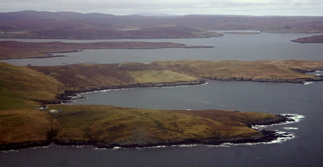
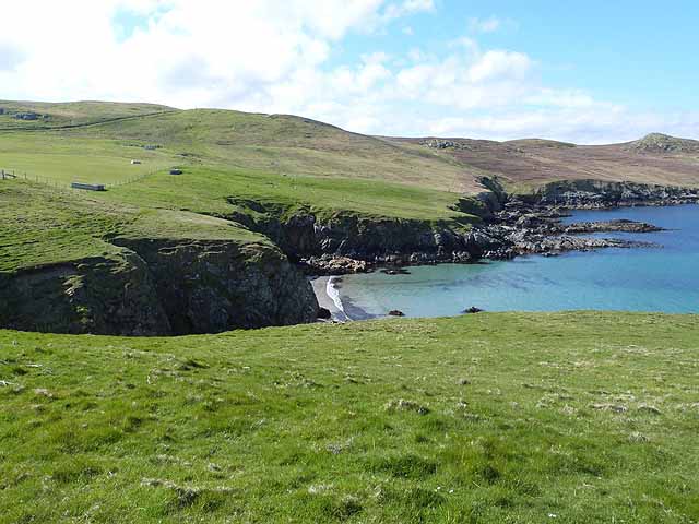
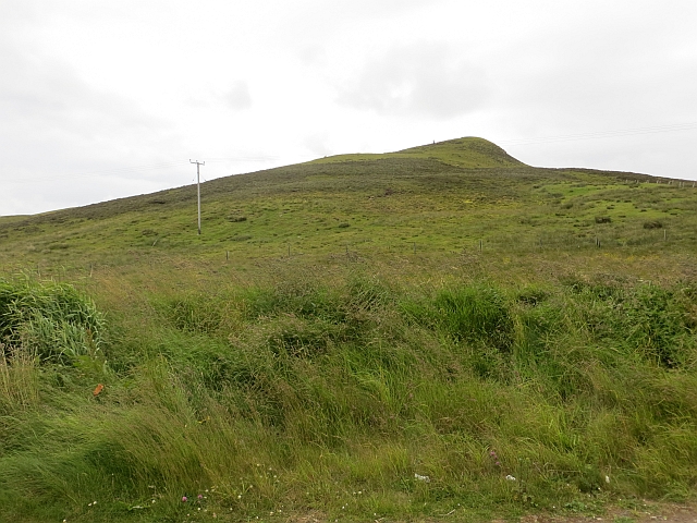
The Bight of Califf, located in Shetland, is a picturesque bay situated on the west coast of the island of Yell. This bay provides a stunning natural harbor and is surrounded by rugged cliffs and rolling hills, offering a truly breathtaking view.

The Bight of Califf is known for its peaceful and tranquil atmosphere, making it a popular destination for nature lovers and those seeking a serene escape. The bay is home to a variety of wildlife, including seals, otters, and seabirds, making it a haven for birdwatchers and wildlife enthusiasts.

The waters of the Bight of Califf are crystal clear and pristine, making it an ideal spot for snorkeling and diving. The underwater landscape is teeming with marine life, including colorful fish, kelp forests, and even the occasional sighting of dolphins or porpoises.

Visitors to the Bight of Califf can explore the bay by boat or kayak, taking in the stunning scenery and enjoying the peace and tranquility. The surrounding cliffs also offer opportunities for hiking and climbing, with breathtaking views of the bay and the surrounding islands.

Overall, the Bight of Califf is a hidden gem in Shetland, offering a perfect blend of natural beauty and tranquility. Whether you are looking to relax on its shores, explore its underwater world, or immerse yourself in its stunning surroundings, this bay is a must-visit destination for nature lovers and adventure seekers alike.

If you have any feedback on the listing, please let us know in the comments section below.

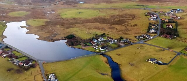
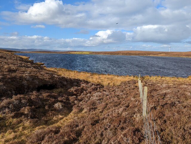
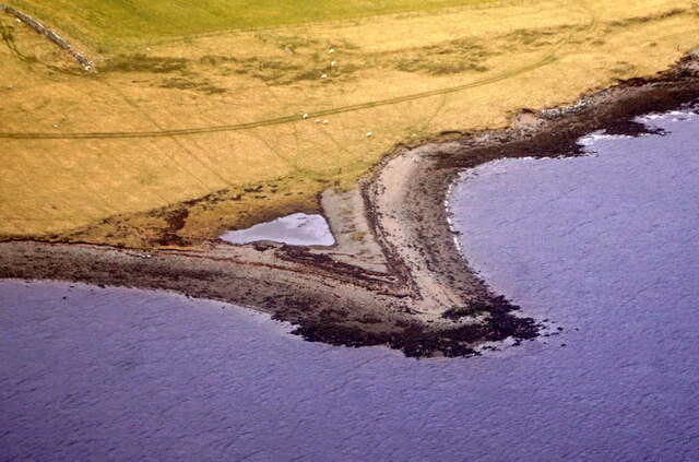
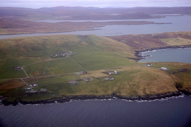
Bight of Califf Images

Images are sourced within 2km of 60.195642/-1.1875424 or Grid Reference HU4545. Thanks to Geograph Open Source API. All images are credited.

Strand Loch from the air
Loch of Kebister Loch of Kebister with raven overhead and the Luggie's Knowe wind turbine to the north.
Loch of Kebister
Loch of Kebister with raven overhead and the Luggie's Knowe wind turbine to the north.
Small headland, Lax Firth, from the air
Breiwick, Tingwall, from the air
Fora Ness and Foraness Voe from the air
Gott: postbox № ZE2 9 and phone These two red objects stand at the junction alongside Strand Loch. The postbox is emptied on weekday and Saturday mornings at 9:30.
Gott: postbox № ZE2 9 and phone
These two red objects stand at the junction alongside Strand Loch. The postbox is emptied on weekday and Saturday mornings at 9:30.
Lower end of Strand Loch The loch empties into Lax Firth a short way to the north. The road follows a causeway across the lower end.
Lower end of Strand Loch
The loch empties into Lax Firth a short way to the north. The road follows a causeway across the lower end.
Strand Loch, Gott The turbines are on the Hill of Burradale <a href="https://www.geograph.org.uk/gridref/HU4242">HU4242</a>.
Strand Loch, Gott
The turbines are on the Hill of Burradale HU4242.
Head of Foraness Voe The beach appears to be virtually inaccessible down the cliffs.
Head of Foraness Voe
The beach appears to be virtually inaccessible down the cliffs.
Road end, Dales Voe Industrial buildings at the end of a large no through road.
Road end, Dales Voe
Industrial buildings at the end of a large no through road.
Luggie's Knowe A shapely small hill near the mouth of Dale's Voe.
Luggie's Knowe
A shapely small hill near the mouth of Dale's Voe.
Wild Gyrfalcon (Falco rusticolus) in captivity, Gott This Gyrfalcon from the Arctic was found onboard a trawler and was taken to the SSPCA centre at Gott, where it was rehabilitated and released on the day that this photo was taken.
Wild Gyrfalcon (Falco rusticolus) in captivity, Gott
This Gyrfalcon from the Arctic was found onboard a trawler and was taken to the SSPCA centre at Gott, where it was rehabilitated and released on the day that this photo was taken.
Vehicle track from Luggies Knowe A rough track made by vehicles strikes across the moor from Luggies Knowe, now the site of a large wind turbine.  The ultimate destination of the track was hard to decipher as on first acquaintance it seemed to peter out.  It does not appear on OS Mapping.
Vehicle track from Luggies Knowe
A rough track made by vehicles strikes across the moor from Luggies Knowe, now the site of a large wind turbine. The ultimate destination of the track was hard to decipher as on first acquaintance it seemed to peter out. It does not appear on OS Mapping.
Peat and bog on Hill of Gremista Soft going with some blanket bog and heather.  The turbine on Luggie's Knowe visible ahead.
Peat and bog on Hill of Gremista
Soft going with some blanket bog and heather. The turbine on Luggie's Knowe visible ahead.
Loch of Kebister A quiet secluded loch under the Hill of Gremista.
Loch of Kebister
A quiet secluded loch under the Hill of Gremista.
Moorland by the Burn of Kebister Heather, grasses and bog dominate the terrain.
Moorland by the Burn of Kebister
Heather, grasses and bog dominate the terrain.
Oil rig being dismantled at Dales Voe, Lerwick The base at Dales Voe was built in anticipation of contracts to build and maintain rigs. Ironically, the first contract for the base was to dismantle a decommissioned rig.
Oil rig being dismantled at Dales Voe, Lerwick
The base at Dales Voe was built in anticipation of contracts to build and maintain rigs. Ironically, the first contract for the base was to dismantle a decommissioned rig.
Shetland's biggest Wind Turbine With a tip height of 121m, the Enercon E-82 E4 is 11m lower than the 3.6 MW turbine on which planning permission was based. Seen from half a mile away, it dominates the skyline of Luggie's Knowe on the northern slopes of Hill of Gremista, but being at 60m above sea level, almost half its height is hidden in views from Lerwick itself. It is designed to continue to produce power in up to force 10 wind - beyond that at which most wind farms give up and run away, but quite important in a location like this. Judging by the performance of the operator's existing turbines, three miles away (the world's most productive onshore wind farm for its size) , it can be expected to have one of the highest load factors in the world, averaging almost 50% of its potential output in November 2017, for example and generating an income of the order of half a million pounds per year. With a capacity of 2.97 MW, it will be making a substantial contribution to the planned 600 MW renewable power export to mainland Scotland via the 1200 MW Caithness-Moray transmission link. Shetland itself is also seeing the benefit, as Luggie's Knowe forms part of the 8.5 MW capacity managed network, whose 1 MW battery at Lerwick Power Station has seen a reduction of 10-15% in diesel consumption at that station. Shetland's power consumption is now about one third renewable energy. Quite impressive for islands whose economy has been so dependent on oil production !
Shetland's biggest Wind Turbine
With a tip height of 121m, the Enercon E-82 E4 is 11m lower than the 3.6 MW turbine on which planning permission was based. Seen from half a mile away, it dominates the skyline of Luggie's Knowe on the northern slopes of Hill of Gremista, but being at 60m above sea level, almost half its height is hidden in views from Lerwick itself. It is designed to continue to produce power in up to force 10 wind - beyond that at which most wind farms give up and run away, but quite important in a location like this. Judging by the performance of the operator's existing turbines, three miles away (the world's most productive onshore wind farm for its size) , it can be expected to have one of the highest load factors in the world, averaging almost 50% of its potential output in November 2017, for example and generating an income of the order of half a million pounds per year. With a capacity of 2.97 MW, it will be making a substantial contribution to the planned 600 MW renewable power export to mainland Scotland via the 1200 MW Caithness-Moray transmission link. Shetland itself is also seeing the benefit, as Luggie's Knowe forms part of the 8.5 MW capacity managed network, whose 1 MW battery at Lerwick Power Station has seen a reduction of 10-15% in diesel consumption at that station. Shetland's power consumption is now about one third renewable energy. Quite impressive for islands whose economy has been so dependent on oil production !
Show me another place!

Bight of Califf is located at Grid Ref: HU4545 (Lat: 60.195642, Lng: -1.1875424)

Unitary Authority: Shetland Islands

Police Authority: Highlands and Islands

What 3 Words

///gasp.beep.shunted. Near Lerwick, Shetland Islands

Related Wikis

Breiwick

Breiwick is a village on the island of Mainland in Shetland, Scotland. Breiwick is in the parish of Tingwall, and is 1.6 mi (2.5 km) north-east of Gott...

Veensgarth

Veensgarth (Old Norse: Vikingsgarðr, Viking farm, or Vingarðr, Meadow Farm), is a village in the Tingwall valley west of Lerwick on Mainland in Shetland...

Böd of Gremista

The Böd of Gremista, situated at the north end of Lerwick, Shetland, Scotland, is a typical 18th century Shetland fishing booth (or böd). It is protected...

Tingwall Airport

Tingwall Airport (IATA: LWK, ICAO: EGET), also known as Lerwick/Tingwall Airport, is located in the Tingwall valley, near the village of Gott, 4 NM (7...

Nearby Amenities

Located within 500m of 60.195642,-1.1875424
Seamark Light 1 Character: Fl
Seamark Light 1 Colour: green
Seamark Light 1 Group: 2
Seamark Light 1 Height: 5
Seamark Light 1 Period: 8
Seamark Light 1 Range: 3
Seamark Light 1 Sector End: 227
Seamark Light 1 Sector Start: 220
Seamark Light 1 Sequence: 0.4+(1.4),0.4+(5.8)
Seamark Light 2 Character: Fl
Seamark Light 2 Colour: white
Seamark Light 2 Group: 2
Seamark Light 2 Height: 5
Seamark Light 2 Period: 8
Seamark Light 2 Range: 4
Seamark Light 2 Sector End: 233
Seamark Light 2 Sector Start: 227
Seamark Light 2 Sequence: 0.4+(1.4),0.4+(5.8)
Seamark Light 3 Character: Fl
Seamark Light 3 Colour: red
Seamark Light 3 Group: 2
Seamark Light 3 Height: 5
Seamark Light 3 Period: 8
Seamark Light 3 Range: 3
Seamark Light 3 Sector End: 240
Seamark Light 3 Sector Start: 233
Seamark Light 3 Sequence: 0.4+(1.4),0.4+(5.8)
Seamark Light Reference: A 3795
Seamark Type: light_minor
Source: US NGA Pub. 114. 2011-05-26.
Lat/Long: 60.1964833/-1.1870167
Barrier: cattle_grid
Lat/Long: 60.1926077/-1.1939194
Power: pole
Lat/Long: 60.1933257/-1.1940803
Power: pole
Lat/Long: 60.1940169/-1.1931817
Power: pole
Lat/Long: 60.1945118/-1.1925557
Power: pole
Lat/Long: 60.1951973/-1.1916825
Power: pole
Lat/Long: 60.1960894/-1.1914215
Power: pole
Lat/Long: 60.1969964/-1.1911628
Power: pole
Lat/Long: 60.1979149/-1.1909063
Power: pole
Lat/Long: 60.1986209/-1.1907008
Power: pole
Lat/Long: 60.1992581/-1.1905183
Power: pole
Lat/Long: 60.193824/-1.1949142
Power: pole
Lat/Long: 60.1933958/-1.195159
Power: pole
Lat/Long: 60.1932557/-1.1929368
Power: pole
Lat/Long: 60.1932063/-1.1920914
Power: pole
Lat/Long: 60.1927114/-1.1924032
The data included in this document is from www.openstreetmap.org. The data is made available under ODbL.

Have you been to Bight of Califf?

Leave your review of Bight of Califf below (or comments, questions and feedback).