Little Yoags' Haven

Bay in Aberdeenshire

Scotland

Little Yoags' Haven

Guillemot Nap Time Guillemots taking a nap on the sheer cliffs of the Bullers of Buchan in Aberdeenshire.
Guillemot Nap Time Credit: Iain Smith

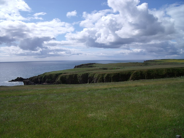
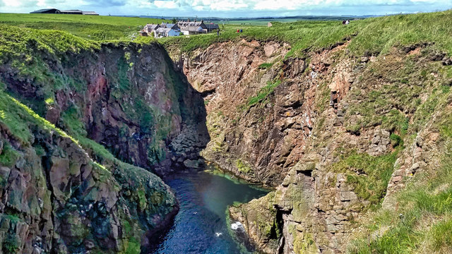
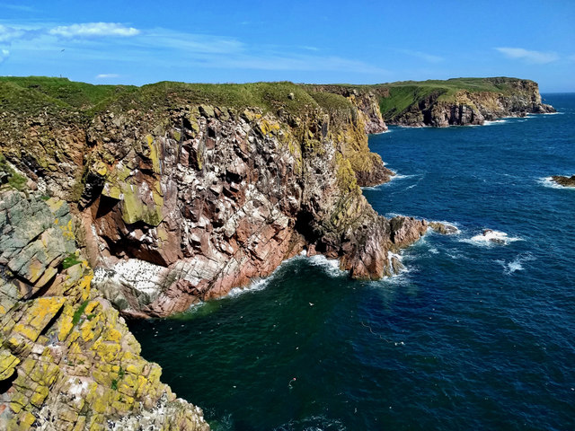
Little Yoags' Haven is a picturesque bay located in Aberdeenshire, Scotland. Nestled along the scenic coastline, this charming haven is renowned for its natural beauty and tranquil atmosphere. With its pristine sandy beach, crystal-clear turquoise waters, and breathtaking panoramic views, it is a popular destination for tourists and locals alike.

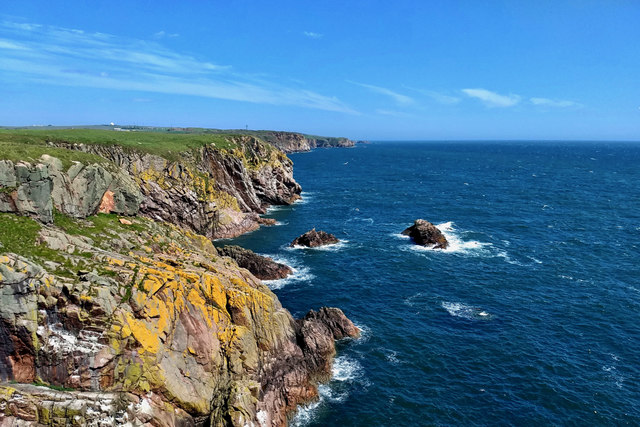
Situated on the northeastern coast of Scotland, Little Yoags' Haven offers visitors a unique blend of tranquility and adventure. The calm waters make it an ideal spot for swimming, snorkeling, and paddleboarding, while the surrounding cliffs provide an excellent backdrop for hiking and birdwatching. The bay is also a favorite spot for photographers, who are captivated by its rugged beauty and stunning sunsets.

The beach itself is relatively secluded, enhancing the sense of tranquility and offering visitors a peaceful retreat. The soft sand is perfect for sunbathing or simply enjoying a leisurely stroll along the shoreline. Additionally, the bay's location provides a sheltered haven from strong winds, making it a suitable spot for picnics and family outings.

Little Yoags' Haven is also home to a diverse range of wildlife. Seals and dolphins can often be spotted frolicking in the bay, while seabirds nest on the surrounding cliffs. The bay's marine ecosystem is rich and vibrant, making it a popular destination for snorkelers and scuba divers seeking to explore the underwater world.

Overall, Little Yoags' Haven offers visitors a serene and idyllic coastal experience. Its natural beauty, peaceful atmosphere, and abundant wildlife make it a must-visit destination for nature lovers and outdoor enthusiasts.

If you have any feedback on the listing, please let us know in the comments section below.

Little Yoags' Haven Images

Images are sourced within 2km of 57.445555/-1.8038727 or Grid Reference NK1139. Thanks to Geograph Open Source API. All images are credited.

Guillemot Nap Time Guillemots taking a nap on the sheer cliffs of the Bullers of Buchan in Aberdeenshire.
Guillemot Nap Time
Guillemots taking a nap on the sheer cliffs of the Bullers of Buchan in Aberdeenshire.
The Pot Looking into The Pot, a collapsed sea cave at the Bullers of Buchan. The North Sea is visible through the arch.
<span class="nowrap"><a title="http://bullersofbuchan.me.uk/" rel="nofollow ugc noopener" href="http://bullersofbuchan.me.uk/">Link</a><img style="margin-left:2px;" alt="External link" title="External link - shift click to open in new window" src="https://s1.geograph.org.uk/img/external.png" width="10" height="10"/></span>
The Pot
Looking into The Pot, a collapsed sea cave at the Bullers of Buchan. The North Sea is visible through the arch. LinkExternal link
Bullers o' Buchan Famous collapsed sea cave on the Buchan coast south of Peterhead.
<span class="nowrap"><a title="http://bullersofbuchan.me.uk/" rel="nofollow ugc noopener" href="http://bullersofbuchan.me.uk/">Link</a><img style="margin-left:2px;" alt="External link" title="External link - shift click to open in new window" src="https://s1.geograph.org.uk/img/external.png" width="10" height="10"/></span>
Bullers o' Buchan
Famous collapsed sea cave on the Buchan coast south of Peterhead. LinkExternal link
The cliffs just south of Bullers of Buchan
At Bullers of Buchan
Bullers of Buchan
Bullers of Buchan
An overbridge and the track bed formation of the Buchan Railway above North Haven
Natural arch at Bullers of Buchan
Bullers of Buchan
Bullers of Buchan
Mussel Craig
Mussel Craig
Cairn-na-hilt
Cairn-na-hilt
Bullers of Buchan Erosion of the cliff into a sea arch.
Bullers of Buchan
Erosion of the cliff into a sea arch.
Old Railway Embankment An embankment and single bridge stanchion, remaining from the former Great North of Scotland Railway as the line headed north.
Old Railway Embankment
An embankment and single bridge stanchion, remaining from the former Great North of Scotland Railway as the line headed north.
Rocky coastline near Little Dumeath The photograph was taken from an A90 parking area. Notice the beautiful clouds.
Rocky coastline near Little Dumeath
The photograph was taken from an A90 parking area. Notice the beautiful clouds.
Den Dam Den Dam, famous in the area for the traditional sailing of model yachts, is located in the area of the Buchan Gravel Ridge, an important source of flint which was quarried by early farmers

The water from the dam fed the watercourse that provided power for the granite works of Sandford Mill near Peterhead.
Den Dam
Den Dam, famous in the area for the traditional sailing of model yachts, is located in the area of the Buchan Gravel Ridge, an important source of flint which was quarried by early farmers The water from the dam fed the watercourse that provided power for the granite works of Sandford Mill near Peterhead.
Long Craig
Long Craig
The Pot
The Pot
Blockie Head
Blockie Head
Show me another place!

Little Yoags' Haven is located at Grid Ref: NK1139 (Lat: 57.445555, Lng: -1.8038727)

Unitary Authority: Aberdeenshire

Police Authority: North East

What 3 Words

///handlebar.fast.sued. Near Boddam, Aberdeenshire

Related Wikis

Longhaven railway station

Longhaven railway station was a railway station in Longhaven, Aberdeen, serving passengers and goods on the line to Boddam. It opened with the branch in...

Longhaven

Longhaven is a village in Aberdeenshire, Scotland, located two miles southwest of Boddam.Longhaven railway station closed in 1948. The village had a primary...

RAF Buchan

Royal Air Force Buchan or more simply RAF Buchan is a former Royal Air Force station near Peterhead in Aberdeenshire, Scotland. Buchan opened in 1952 as...

RRH Buchan

Remote Radar Head Buchan or RRH Buchan is an air defence radar station operated by the Royal Air Force. It is located at Stirling Hill, 3.2 kilometres...

Bullers of Buchan

The name Bullers of Buchan refers both to a collapsed sea cave and to the adjacent village, situated about 6 miles (9.7 km) south of Peterhead in Buchan...

Bullers O'Buchan Platform railway station

Bullers O'Buchan Platform railway station also known as Bullers O'Buchan Halt railway station was a railway station serving visitors to the Bullers of...

Boddam Castle

Boddam Castle is a ruined castle in Boddam, Aberdeenshire, Scotland. It was thought to have been built in the early 16th century as a seat for the Keiths...

Stirling Village

Stirling Village is a settlement in the Buchan area of Aberdeenshire, Scotland, located on the A90 road immediately to the west of Boddam and 3 miles...

Nearby Amenities

Located within 500m of 57.445555,-1.8038727
Source: OS7
Lat/Long: 57.4490314/-1.7986994
Source: OS7
Lat/Long: 57.4481448/-1.7991446
Source: Old Landsat image trace
Lat/Long: 57.4472222/-1.7974403
Source: Old Landsat image trace
Lat/Long: 57.4468985/-1.7978557
Source: Old Landsat image trace
Lat/Long: 57.4465162/-1.7986312
Source: Old Landsat image trace
Lat/Long: 57.4460806/-1.7995518
Source: OS7
Lat/Long: 57.4453495/-1.8057304
Source: OS7
Lat/Long: 57.4449621/-1.8051265
Source: OS7
Lat/Long: 57.4435453/-1.8045058
Source: OS7
Lat/Long: 57.4430187/-1.8054844
Source: OS7
Lat/Long: 57.4433562/-1.8054789
Source: OS7
Lat/Long: 57.4429254/-1.8061062
Source: OS7
Lat/Long: 57.4423455/-1.8082651
Source: Old Landsat image trace
Lat/Long: 57.4422525/-1.8064304
Source: Old Landsat image trace
Lat/Long: 57.4417179/-1.8074902
Source: OS7
Lat/Long: 57.4487996/-1.7992308
Source: OS7
Lat/Long: 57.4475398/-1.7992631
Source: OS7
Lat/Long: 57.445555/-1.8041721
Longhaven Cliffs (Scottish Wildlife Trust)
Leisure: nature_reserve
Url: http://scottishwildlifetrust.org.uk/reserve/longhaven-cliffs/
Lat/Long: 57.4463837/-1.8001144
Blackhills
Place: locality
Lat/Long: 57.4457002/-1.8090515
Ele: 72
Natural: peak
Lat/Long: 57.4426178/-1.8091374
Murdoch Head
Natural: cape
Lat/Long: 57.4467562/-1.7981484
South Glash
Natural: bay
Lat/Long: 57.4459595/-1.800262
north Glash
Natural: bay
Lat/Long: 57.4477087/-1.7980626
Little Pricker
Natural: cape
Lat/Long: 57.4472238/-1.797376
Yoags Haven
Natural: bay
Lat/Long: 57.4450243/-1.8044463
The Gwight
Natural: bay
Lat/Long: 57.4424666/-1.807343
The Bow
Natural: bay
Lat/Long: 57.4455554/-1.8022468
Watery Haven
Natural: bay
Source: OS Opendata Streetmap
Lat/Long: 57.4487621/-1.7987411
The data included in this document is from www.openstreetmap.org. The data is made available under ODbL.

Have you been to Little Yoags' Haven?

Leave your review of Little Yoags' Haven below (or comments, questions and feedback).