Bruce's Haven

Bay in Aberdeenshire

Scotland

Bruce's Haven

Old Slains Castle
Old Slains Castle Credit: Alan Reid

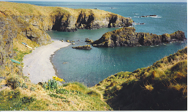
Bruce's Haven is a small coastal bay located in the picturesque region of Aberdeenshire, Scotland. Situated along the North Sea coastline, this tranquil haven offers visitors a glimpse into the region's rich history and natural beauty.

Named after King Robert the Bruce, who is said to have sought refuge in this very bay during the 14th century, Bruce's Haven boasts a unique historical significance. The bay was once a bustling trading port, serving as a crucial link between the mainland and the northern isles. Although its prominence as a port has diminished over the years, remnants of its maritime past can still be seen in the form of weathered stone structures and a small pier.

Beyond its historical allure, Bruce's Haven is renowned for its stunning natural surroundings. The bay is flanked by rugged cliffs, providing breathtaking views of the North Sea and the surrounding coastline. The area is also home to a diverse range of flora and fauna, making it a haven for nature enthusiasts and birdwatchers.

Visitors to Bruce's Haven can enjoy a leisurely stroll along the sandy beach, take in the fresh sea air, and explore the rock pools teeming with marine life. The bay is also a popular spot for water sports such as kayaking and paddleboarding, offering visitors a chance to engage in thrilling activities amidst the serene coastal backdrop.

Overall, Bruce's Haven is a captivating destination that seamlessly blends history and natural beauty, making it a must-visit for those seeking a tranquil retreat in the heart of Aberdeenshire.

If you have any feedback on the listing, please let us know in the comments section below.

Bruce's Haven Images

Images are sourced within 2km of 57.372624/-1.8924208 or Grid Reference NK0631. Thanks to Geograph Open Source API. All images are credited.

Old Slains Castle
Old Slains Castle
Broad Haven Looking north-east up the coastline to Broad Haven.
Broad Haven
Looking north-east up the coastline to Broad Haven.
A species from the deep past The common horse-tail, Equisetum arvense, is an ancient species of plant whose ancestors were browsed by dinosaurs. Modern horsetails are only a few centimetres high but their ancestors included tree-like species up to 200 feet in height living in the Carboniferous forests. They all evolved long before the flowering plants came along and they produce spores rather than seeds. 

Horsetails grow in moist, rich soils in all parts of the world except Australasia. Some, including ours, produce two kinds of shoots. The first shoots to emerge in the spring are the reproductive squad and are topped with cone-like clusters of spore capsules. These are the ones in the photograph. In a couple of weeks time they will be replaced with green shoots whose role in life will be photosynthesis, growth and replenishing the energy stores.
A species from the deep past
The common horse-tail, Equisetum arvense, is an ancient species of plant whose ancestors were browsed by dinosaurs. Modern horsetails are only a few centimetres high but their ancestors included tree-like species up to 200 feet in height living in the Carboniferous forests. They all evolved long before the flowering plants came along and they produce spores rather than seeds. Horsetails grow in moist, rich soils in all parts of the world except Australasia. Some, including ours, produce two kinds of shoots. The first shoots to emerge in the spring are the reproductive squad and are topped with cone-like clusters of spore capsules. These are the ones in the photograph. In a couple of weeks time they will be replaced with green shoots whose role in life will be photosynthesis, growth and replenishing the energy stores.
Particoloured Tup This smart and rather unusual fellow was one of half a dozen tups roaming the cliffs. The others were mostly uniform in colour.
Particoloured Tup
This smart and rather unusual fellow was one of half a dozen tups roaming the cliffs. The others were mostly uniform in colour.
Fold Hinge Although it looks like a continuation, the section of the hinge in the black rocks is actually separated from the part on the left by a narrow sea inlet. This can be seen in <a href="https://www.geograph.org.uk/photo/1945678">NK0630 : Still More of the Recumbent Fold</a>.
Fold Hinge
Although it looks like a continuation, the section of the hinge in the black rocks is actually separated from the part on the left by a narrow sea inlet. This can be seen in NK0630 : Still More of the Recumbent Fold.
Folding the other way The most prominent hinges here close to the left, but this shows the other part of the structure, closing to the right, the whole forming an S-shaped fold.
Folding the other way
The most prominent hinges here close to the left, but this shows the other part of the structure, closing to the right, the whole forming an S-shaped fold.
Field Mushroom? I can't be certain what this is. There were several in the grass by the path. Any help with identification will be welcome.
Field Mushroom?
I can't be certain what this is. There were several in the grass by the path. Any help with identification will be welcome.
Mushrooms or Toadstools? Someone or something had uprooted the large fungus, so I moved it closer to the ones still in situ. I do not know what they are; I can only say that the large one did not smell at all appetising. Any help with identification welcome.
Mushrooms or Toadstools?
Someone or something had uprooted the large fungus, so I moved it closer to the ones still in situ. I do not know what they are; I can only say that the large one did not smell at all appetising. Any help with identification welcome.
South Newclochtow A clump of thistles clusters round the fence near South Newclochtow. There is barley on the field to the right, and grass with clover in the field on the left.
South Newclochtow
A clump of thistles clusters round the fence near South Newclochtow. There is barley on the field to the right, and grass with clover in the field on the left.
View towards Old Slains Castle from the coastal path A couple of very isolated houses sit beside the ruin.
View towards Old Slains Castle from the coastal path
A couple of very isolated houses sit beside the ruin.
Old Slains Castle Bram Stoker visited New Slains Castle and was inspired by
Old Slains Castle
Bram Stoker visited New Slains Castle and was inspired by
Berry's Loup
Berry's Loup
Oil Pipeline Booster Station The pipeline bringing oil from the Forties Field and other integrated locations makes its landfall just south of Cruden Bay... (Cruden Bay / Crude Oil - very apt) Pumping Station to assist the black gold's onward route to Grangemouth Refinery.
Oil Pipeline Booster Station
The pipeline bringing oil from the Forties Field and other integrated locations makes its landfall just south of Cruden Bay... (Cruden Bay / Crude Oil - very apt) Pumping Station to assist the black gold's onward route to Grangemouth Refinery.
Oilseed Rape field at Brownhill A very desolate and unattractive looking crop! The left set of buildings in the distance is the Oil Terminal for the North Sea Forties Field - which gives a nice 'Oilseed and Crude Oil' juxtaposition.
Oilseed Rape field at Brownhill
A very desolate and unattractive looking crop! The left set of buildings in the distance is the Oil Terminal for the North Sea Forties Field - which gives a nice 'Oilseed and Crude Oil' juxtaposition.
The farm of Clochtow Part of Slains Estate Clochtow farm lies North of the fishing village of Collieston in an area of fertile land overlooking the North Sea
The farm of Clochtow
Part of Slains Estate Clochtow farm lies North of the fishing village of Collieston in an area of fertile land overlooking the North Sea
Sheep, mud and grass A typical agricultural scene in the rich farming land bordering the North Sea, North of Collieston.
Sheep, mud and grass
A typical agricultural scene in the rich farming land bordering the North Sea, North of Collieston.
North Sea Oil landfall This is a pumping booster station on the pipeline carrying oil from the North Sea.
North Sea Oil landfall
This is a pumping booster station on the pipeline carrying oil from the North Sea.
Old Slains Castle About halfway between Aberdeen and Peterhead, stand the clifftop ruins of Old Slains castle, an ancient seat of the Hay family, Earls of Erroll. The lands of Slains were gifted to Sir Gilbert Hay by King Robert the Bruce of Scots (1306 - 1329) for his loyal service during the 'wars of Independence' against the English. In 1594 both Old Slains and another seat of the Hay family, Delgatie castle, were destroyed by King James VI of Scotland (1567 - 1603) in retribution for the Hays involvement in the Roman Catholic/Spanish plot.
The modern A frame house was built by the Countess of Errol. 
More details can be seen at: <span class="nowrap"><a title="http://www.maybole.org/history/castles/oldslains.htm" rel="nofollow ugc noopener" href="http://www.maybole.org/history/castles/oldslains.htm">Link</a><img style="margin-left:2px;" alt="External link" title="External link - shift click to open in new window" src="https://s1.geograph.org.uk/img/external.png" width="10" height="10"/></span>
Old Slains Castle
About halfway between Aberdeen and Peterhead, stand the clifftop ruins of Old Slains castle, an ancient seat of the Hay family, Earls of Erroll. The lands of Slains were gifted to Sir Gilbert Hay by King Robert the Bruce of Scots (1306 - 1329) for his loyal service during the 'wars of Independence' against the English. In 1594 both Old Slains and another seat of the Hay family, Delgatie castle, were destroyed by King James VI of Scotland (1567 - 1603) in retribution for the Hays involvement in the Roman Catholic/Spanish plot. The modern A frame house was built by the Countess of Errol. More details can be seen at: LinkExternal link
Show me another place!

Bruce's Haven is located at Grid Ref: NK0631 (Lat: 57.372624, Lng: -1.8924208)

Unitary Authority: Aberdeenshire

Police Authority: North East

What 3 Words

///reinvest.examine.overlaps. Near Port Erroll, Aberdeenshire

Related Wikis

Nearby Amenities

Located within 500m of 57.372624,-1.8924208
Source: OS7
Lat/Long: 57.3747013/-1.885681
Source: OS7
Lat/Long: 57.3742773/-1.8871498
Source: OS7
Lat/Long: 57.3728427/-1.8906474
Source: OS7
Lat/Long: 57.3737671/-1.8927288
Source: OS7
Lat/Long: 57.3737474/-1.8935678
Source: OS7
Lat/Long: 57.3724291/-1.8936826
Source: OS7
Lat/Long: 57.3706652/-1.8965042
Source: OS7
Lat/Long: 57.3707208/-1.8989612
Source: OS7
Lat/Long: 57.370118/-1.8989419
Source: OS7
Lat/Long: 57.3698496/-1.898826
Source: OS7
Lat/Long: 57.3708388/-1.8958659
Source: OS7
Lat/Long: 57.371441/-1.8947716
Source: OS7
Lat/Long: 57.3729833/-1.8917578
Source: OS7
Lat/Long: 57.3732112/-1.8882441
Pissing Yad
Waterway: waterfall
Lat/Long: 57.3720213/-1.9004305
Pissing Yad
Place: locality
Lat/Long: 57.3705097/-1.898613
The data included in this document is from www.openstreetmap.org. The data is made available under ODbL.

Have you been to Bruce's Haven?

Leave your review of Bruce's Haven below (or comments, questions and feedback).