Whitemill Bay

Bay in Orkney

Scotland

Whitemill Bay

Whitemill Bay, Sanday, Orkney
Whitemill Bay, Sanday, Orkney Credit: Karl Cooper

Whitemill Bay is a picturesque bay located on the island of Orkney in Scotland. Situated on the eastern coast of the island, it offers stunning views of the North Sea and is a popular destination for both locals and tourists.

The bay is characterized by its pristine sandy beach, which stretches for approximately 500 meters. The sand is soft and golden, making it an ideal spot for sunbathing, picnicking, and leisurely walks along the shoreline. The crystal-clear waters of the bay are also perfect for swimming, although caution is advised due to strong currents at times.

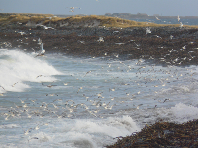
Surrounding the bay are rolling green hills and cliffs that provide a dramatic backdrop to the idyllic scenery. These cliffs are home to a variety of seabirds, including puffins, fulmars, and guillemots, making it a paradise for birdwatchers and nature enthusiasts.

Whitemill Bay is also known for its historical significance. Nearby, there are remnants of an old World War II radar station, which adds a touch of intrigue to the area. Visitors can explore these ruins and learn about the role they played in defending the island during the war.

In terms of facilities, Whitemill Bay offers parking spaces for visitors, as well as public toilets and a small café nearby for refreshments. It is easily accessible by car, with a well-maintained road leading to the bay.

Overall, Whitemill Bay is a charming and tranquil destination that showcases the natural beauty and history of Orkney. Whether one is seeking relaxation on the beach, birdwatching opportunities, or a glimpse into the island's past, this bay has something to offer for everyone.

If you have any feedback on the listing, please let us know in the comments section below.

Whitemill Bay Images

Images are sourced within 2km of 59.308602/-2.5422833 or Grid Reference HY6947. Thanks to Geograph Open Source API. All images are credited.

Whitemill Bay, Sanday, Orkney
North end of Burness Looking south
North end of Burness
Looking south
Whitemill Bay
Whitemill Bay
Fishing! Seagulls attempting to feed as the waves crashed onto the shore at Whitemill Bay.  Tofts can be seen in the distance.
Fishing!
Seagulls attempting to feed as the waves crashed onto the shore at Whitemill Bay. Tofts can be seen in the distance.
Shore south of Whitemill Point
Looking NorthEast toward The Riv. Sanday The Riv is a group of rocky islands stretching out into the sea.
Looking NorthEast toward The Riv. Sanday
The Riv is a group of rocky islands stretching out into the sea.
Whitemill Point, Sanday, Orkney The name Whitemill is derived from the old Norse word melr which means sandbank.  There are extensive sand dunes backing onto Whitemill Bay to the west of the point.
Whitemill Point, Sanday, Orkney
The name Whitemill is derived from the old Norse word melr which means sandbank. There are extensive sand dunes backing onto Whitemill Bay to the west of the point.
Shingle on The Riv, Sanday
Howbell Farm, Sanday in a sea of grass
Beach at Whitemill Bay, Sanday
Sanday - Ortie abandoned village - Street view Looking along the straight row of abandoned dwellings that formed the street in the  former village of Ortie in the northeast of the isle of Sanday.
Sanday - Ortie abandoned village - Street view
Looking along the straight row of abandoned dwellings that formed the street in the former village of Ortie in the northeast of the isle of Sanday.
Sanday - Ortie abandoned village - Byres or barns As well as the abandoned houses of the former village of Ortie on Sanday, there are also ruined buildings associated with farming, such as these structures which were probably byres (for farmstock) or possibly barns for produce.
See shared description below.
Sanday - Ortie abandoned village - Byres or barns
As well as the abandoned houses of the former village of Ortie on Sanday, there are also ruined buildings associated with farming, such as these structures which were probably byres (for farmstock) or possibly barns for produce. See shared description below.
Sanday - Ortie abandoned village - Roofless buildings A view of the eastern end of the abandoned village of Ortie looking back from between the village and the coast.
See shared description below:
Sanday - Ortie abandoned village - Roofless buildings
A view of the eastern end of the abandoned village of Ortie looking back from between the village and the coast. See shared description below:
Sanday - Ortie abandoned village - Street from southeast A grassy track leads along <a href="https://www.geograph.org.uk/photo/7561429">HY6845 : Sanday - Ortie abandoned village - Street view</a> and exits the village at its eastern end then bends southeastwards. This photo is from just after that bend looking back at the village's derelict houses.
See shared description below:
Sanday - Ortie abandoned village - Street from southeast
A grassy track leads along HY6845 : Sanday - Ortie abandoned village - Street view and exits the village at its eastern end then bends southeastwards. This photo is from just after that bend looking back at the village's derelict houses. See shared description below:
Beach next to abandoned village of Ortie, looking ENE The view south-southwestwards along the beach to the east of the abandoned village of Ortie.
For the view the other way along the beach, see <a href="https://www.geograph.org.uk/photo/7561459">HY6844 : Beach next to abandoned village of Ortie, looking SSW</a>
See also shared description below.
Beach next to abandoned village of Ortie, looking ENE
The view south-southwestwards along the beach to the east of the abandoned village of Ortie. For the view the other way along the beach, see HY6844 : Beach next to abandoned village of Ortie, looking SSW See also shared description below.
Hucklinsowe rocks
Hucklinsowe rocks
Whitemill Bay, Sanday, Orkney
Show me another place!

Whitemill Bay is located at Grid Ref: HY6947 (Lat: 59.308602, Lng: -2.5422833)

Unitary Authority: Orkney Islands

Police Authority: Highlands and Islands

What 3 Words

///purifier.argue.recent. Near Hollandstoun, Orkney Islands

Nearby Locations

Whitemill Bay

Related Wikis

Scar boat burial

The Scar boat burial is a Viking boat burial near the village of Scar, on Sanday, in Orkney, Scotland. The burial, which dates to between 875 and 950 AD...

Scar, Orkney

Scar is a village and farm complex on the island of Sanday in Orkney, Scotland. The B9068 road runs from Scar to Kettletoft. The Scar boat burial was found...

East Sanday Coast

The East Sanday Coast is a protected wetland area on and around the island of Sanday, the third-largest of the Orkney islands off the north coast of Scotland...

Sanday, Orkney

Sanday (, Scots: Sandee) is one of the inhabited islands of Orkney that lies off the north coast of mainland Scotland. With an area of 50.43 km2 (19.5...

Nearby Amenities

Located within 500m of 59.308602,-2.5422833
Whitemill Bay
Natural: bay
Lat/Long: 59.3055327/-2.541039
The data included in this document is from www.openstreetmap.org. The data is made available under ODbL.

Have you been to Whitemill Bay?

Leave your review of Whitemill Bay below (or comments, questions and feedback).