Castlesea Bay

Bay in Angus

Scotland

Castlesea Bay

Three Sisters Also known as the Camel's Humps, and the one on the left as the Sphinx, this rib of Old Red Sandstone is at the south end of Carlingheugh Bay.
Three Sisters Credit: Anne Burgess

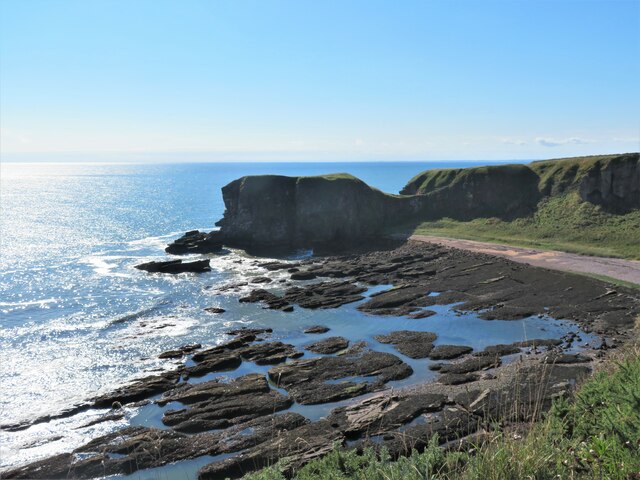
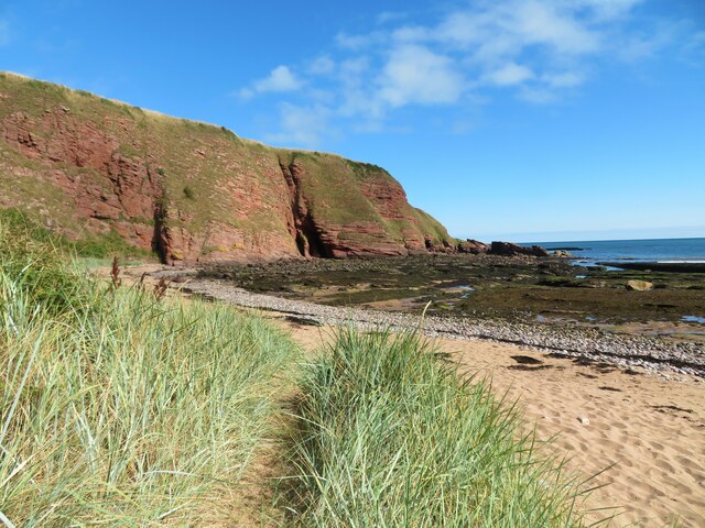
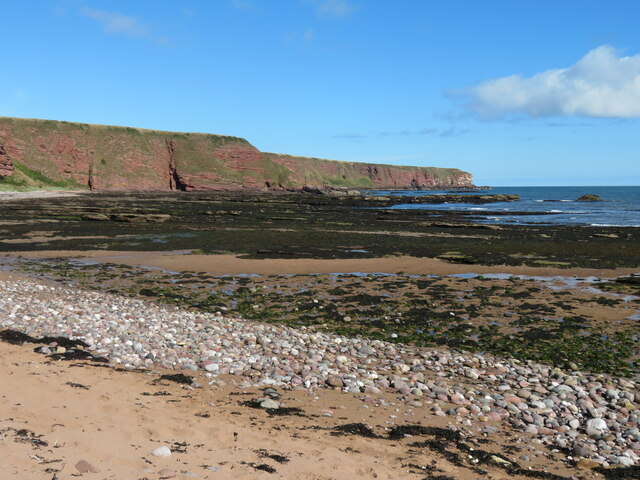
Castlesea Bay is a picturesque bay located in the county of Angus, Scotland. Situated along the eastern coast of the country, it offers stunning views of the North Sea and is a popular destination for locals and tourists alike.

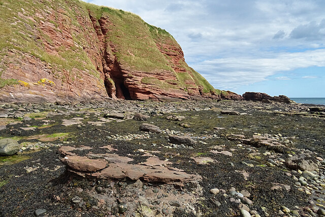
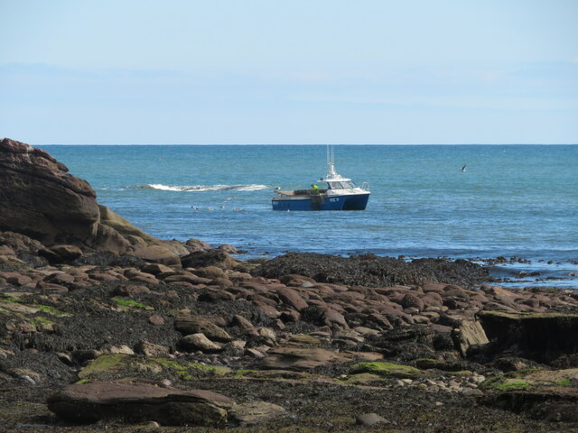
The bay is characterized by its beautiful sandy beach, which stretches for approximately 1.5 miles. The sand is soft and golden, making it an ideal spot for sunbathing, picnicking, and leisurely walks along the shore. The calm and clear waters of the bay also provide opportunities for swimming and other water activities during the summer months.

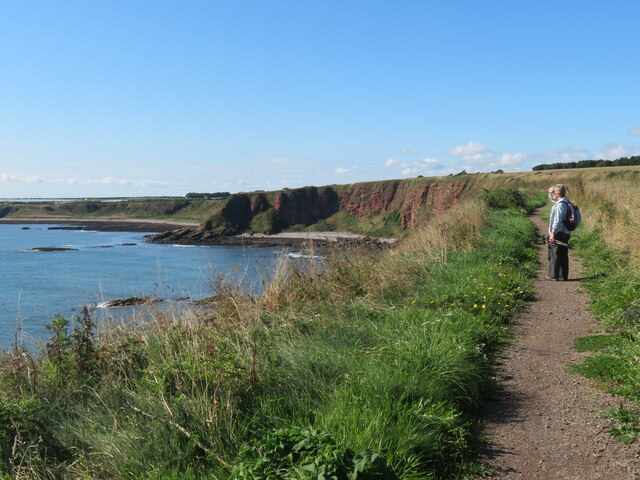
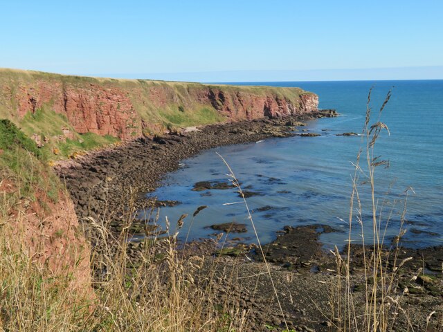
Surrounding the bay are rolling green hills, adding to the area's natural beauty. Visitors can enjoy scenic walks along the clifftops, offering panoramic views of the bay and its surroundings. The area is also rich in wildlife, with seabirds such as gulls and puffins often spotted along the coast.

Castlesea Bay is easily accessible, with a car park located nearby and regular bus services connecting it to the nearby town of Arbroath. The bay also has a small café and toilet facilities for the convenience of visitors.

Overall, Castlesea Bay is a charming and tranquil destination, offering a perfect blend of natural beauty and recreational opportunities. Whether for a relaxing day at the beach or an exploration of the surrounding countryside, this bay is a must-visit for those seeking to experience the beauty of Angus.

If you have any feedback on the listing, please let us know in the comments section below.

Castlesea Bay Images

Images are sourced within 2km of 56.58405/-2.5192425 or Grid Reference NO6843. Thanks to Geograph Open Source API. All images are credited.

Three Sisters Also known as the Camel's Humps, and the one on the left as the Sphinx, this rib of Old Red Sandstone is at the south end of Carlingheugh Bay.
Three Sisters
Also known as the Camel's Humps, and the one on the left as the Sphinx, this rib of Old Red Sandstone is at the south end of Carlingheugh Bay.
Musical Railings A much more imaginative way of fencing off a cliff edge than just an ordinary set of railings. Well done to someone for this. See also <a href="https://www.geograph.org.uk/photo/6630448">NO6642 : The Music Notes on the Arbroath Cliff Trail near Castle Gate</a>.
Musical Railings
A much more imaginative way of fencing off a cliff edge than just an ordinary set of railings. Well done to someone for this. See also NO6642 : The Music Notes on the Arbroath Cliff Trail near Castle Gate.
Castle Gate This is the view to seaward after passing through the natural archat Castle Gate. It's another of the collapsed caves that are common along this stretch of cliffs.
Castle Gate
This is the view to seaward after passing through the natural archat Castle Gate. It's another of the collapsed caves that are common along this stretch of cliffs.
Castle Gate This is one of many natural arches in the cliffs between Arbroath and Lunan Bay. The rock is Old Red Sandstone, laid down by rivers in a desert environment in the Devonian, about 400 million years ago. The coarser layers containing pebbles were deposited when there was a more vigorous flow of water, perhaps flash floods following occasional heavy rain, and the finer beds were laid down in times of slack water. See also <a href="https://www.geograph.org.uk/photo/6652924">NO6742 : A geological story revealed by the Three Sisters, Arbroath</a>.
Castle Gate
This is one of many natural arches in the cliffs between Arbroath and Lunan Bay. The rock is Old Red Sandstone, laid down by rivers in a desert environment in the Devonian, about 400 million years ago. The coarser layers containing pebbles were deposited when there was a more vigorous flow of water, perhaps flash floods following occasional heavy rain, and the finer beds were laid down in times of slack water. See also NO6742 : A geological story revealed by the Three Sisters, Arbroath.
Cliffs in Carlingheugh Bay The cleft in the cliff is a fault which has been exploited by the sea to form the Dark Cave, one of two caves that extend right through the headland to the next bay. The other one, the Light Cave, is further to the right. When you enter the Light cave, you can see the light at the other end, but the Dark Cave is, as its name suggests, completely dark. Bring a torch if you're going to explore it, and mind your head inside. The slightly wavy almost vertical feature next to the cave entrance is a vein of baryte (Barium sulphate, BaSO4, also known as barite and barytes). This has leached out of the sandstone and there are several such veins in the vicinity. Baryte is very dense (about 4½ tonnes per cubic metre, compared with sandstone which has a density of about 2¼ tonnes per cubic metre) and is used to make drilling mud to seal oil wells, and it is the most important ore of barium, which has many uses in medicine, engineering and other fields. See <span class="nowrap"><a title="https://en.wikipedia.org/wiki/Baryte" rel="nofollow ugc noopener" href="https://en.wikipedia.org/wiki/Baryte">Link</a><img style="margin-left:2px;" alt="External link" title="External link - shift click to open in new window" src="https://s1.geograph.org.uk/img/external.png" width="10" height="10"/></span>.
Cliffs in Carlingheugh Bay
The cleft in the cliff is a fault which has been exploited by the sea to form the Dark Cave, one of two caves that extend right through the headland to the next bay. The other one, the Light Cave, is further to the right. When you enter the Light cave, you can see the light at the other end, but the Dark Cave is, as its name suggests, completely dark. Bring a torch if you're going to explore it, and mind your head inside. The slightly wavy almost vertical feature next to the cave entrance is a vein of baryte (Barium sulphate, BaSO4, also known as barite and barytes). This has leached out of the sandstone and there are several such veins in the vicinity. Baryte is very dense (about 4½ tonnes per cubic metre, compared with sandstone which has a density of about 2¼ tonnes per cubic metre) and is used to make drilling mud to seal oil wells, and it is the most important ore of barium, which has many uses in medicine, engineering and other fields. See LinkExternal link.
Barite Crystals The white dendritic shapes are crystals of Barium sulphate, BaSO4, also known as barite and baryte, which have leached out from igneous fluids permeating the sandstone. Baryte is very dense (about 4½ tonnes per cubic metre, compared with sandstone which has a density of about 2¼ tonnes per cubic metre) and is used to make drilling mud to seal oil wells, and it is the most important ore of barium, which has many uses in medicine, engineering and other fields. See <span class="nowrap"><a title="https://en.wikipedia.org/wiki/Baryte" rel="nofollow ugc noopener" href="https://en.wikipedia.org/wiki/Baryte">Link</a><img style="margin-left:2px;" alt="External link" title="External link - shift click to open in new window" src="https://s1.geograph.org.uk/img/external.png" width="10" height="10"/></span>.
Barite Crystals
The white dendritic shapes are crystals of Barium sulphate, BaSO4, also known as barite and baryte, which have leached out from igneous fluids permeating the sandstone. Baryte is very dense (about 4½ tonnes per cubic metre, compared with sandstone which has a density of about 2¼ tonnes per cubic metre) and is used to make drilling mud to seal oil wells, and it is the most important ore of barium, which has many uses in medicine, engineering and other fields. See LinkExternal link.
Cove Haven Cove Haven is separated by the Three Sisters from Carlingheugh Bay.
Cove Haven
Cove Haven is separated by the Three Sisters from Carlingheugh Bay.
But n Ben restaurant, Auchmithie Restaurant in a traditional cottage style building at the start of the old part of the clifftop village.
But n Ben restaurant, Auchmithie
Restaurant in a traditional cottage style building at the start of the old part of the clifftop village.
St Peter's Church, Auchmithie Scottish Episcopal Church situated at the western end of the village.
St Peter's Church, Auchmithie
Scottish Episcopal Church situated at the western end of the village.
Across Castlesea Bay Looking south across the bay to the promontory of Lud Castle, which is an iron age fort.
Across Castlesea Bay
Looking south across the bay to the promontory of Lud Castle, which is an iron age fort.
Harvested field south of Auchmithie A view from the coast path looking inland across a recently cropped field towards Auchmithie church.
Harvested field south of Auchmithie
A view from the coast path looking inland across a recently cropped field towards Auchmithie church.
Walking the coast path towards Carlingheugh Bay Not sure if this is one bay or two as the small rocky promontory centre left appears to form a sort of break.
Walking the coast path towards Carlingheugh Bay
Not sure if this is one bay or two as the small rocky promontory centre left appears to form a sort of break.
Devonian sandstone meets the North Sea The red cliffs of Angus are made from Devonian period sandstone - a sedimentary rock.
Devonian sandstone meets the North Sea
The red cliffs of Angus are made from Devonian period sandstone - a sedimentary rock.
Beach at the northern end of Carlingheugh Bay An ideal lunch spot on a walk from Auchmithie to Arbroath. Sand gives way to pebbles and then a wave cut platform festooned with seaweed. The Dark Cave is prominent in the centre of the picture, formed on a minor fault line.
Beach at the northern end of Carlingheugh Bay
An ideal lunch spot on a walk from Auchmithie to Arbroath. Sand gives way to pebbles and then a wave cut platform festooned with seaweed. The Dark Cave is prominent in the centre of the picture, formed on a minor fault line.
Lobster fishing off Carlingheugh Bay Small fishing boat close to shore checking out lobster pots.
Lobster fishing off Carlingheugh Bay
Small fishing boat close to shore checking out lobster pots.
Carlingheugh Bay Looking north along the bay and showing the mix of sand, pebble and rocky ribs extending out into the sea.
Carlingheugh Bay
Looking north along the bay and showing the mix of sand, pebble and rocky ribs extending out into the sea.
Just 70 steps to the top Stepped path leading up from the beach at Carlingheugh Bay. Such ascents become longer and steeper as one gets older. Both Dark Cave and Light Cave are visible on the headland.
Just 70 steps to the top
Stepped path leading up from the beach at Carlingheugh Bay. Such ascents become longer and steeper as one gets older. Both Dark Cave and Light Cave are visible on the headland.
Musical fence above Carlingheugh Bay An unusual feature by the coast path. I've not worked out the tune. Maybe it's something by Cliff [Richard] or a rock anthem?
Musical fence above Carlingheugh Bay
An unusual feature by the coast path. I've not worked out the tune. Maybe it's something by Cliff [Richard] or a rock anthem?
Show me another place!

Castlesea Bay is located at Grid Ref: NO6843 (Lat: 56.58405, Lng: -2.5192425)

Unitary Authority: Angus

Police Authority: Tayside

What 3 Words

///massaging.gagging.sourced. Near Arbroath, Angus

Nearby Locations

Castlesea Bay Meg's Craig

Related Wikis

Auchmithie

Auchmithie is a small fishing village in Angus, Scotland, three miles north east of the town of Arbroath. It sits atop a cliff of red sandstone conglomerate...

West Seaton House

West Seaton House is a listed building of late Regency design, situated approximately one mile (1.6 km) to the east of Arbroath in the parish of St. Vigeans...
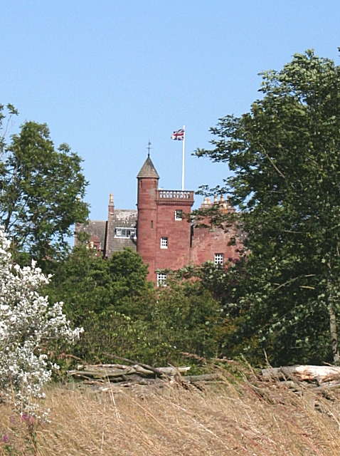
Ethie Castle

Ethie Castle is a 15,091 square feet (1,402.0 m2) 14th-century castle, situated around 3 miles north of the fishing town of Arbroath in Angus, Scotland...

Marywell

Marywell is a village in Angus, Scotland, that is north of Arbroath, in the parish of St Vigeans. == References == == Sources == Marywell in the Gazetteer...

Nearby Amenities

Located within 500m of 56.58405,-2.5192425
Created By: almien_coastlines
Source: PGS
Lat/Long: 56.581692/-2.52043
Created By: almien_coastlines
Source: PGS
Lat/Long: 56.581694/-2.520894
Created By: almien_coastlines
Source: PGS
Lat/Long: 56.58195/-2.520891
Created By: almien_coastlines
Source: PGS
Lat/Long: 56.581948/-2.520427
Source: PGS
Lat/Long: 56.5804643/-2.5226806
Created By: almien_coastlines
Source: PGS
Lat/Long: 56.580932/-2.522528
Created By: almien_coastlines
Source: PGS
Lat/Long: 56.581059/-2.522294
Source: PGS
Lat/Long: 56.5812468/-2.5209619
Created By: almien_coastlines
Source: PGS
Lat/Long: 56.581696/-2.521591
Created By: almien_coastlines
Source: PGS
Lat/Long: 56.58221/-2.522048
Created By: almien_coastlines
Source: PGS
Lat/Long: 56.58464/-2.521321
Created By: almien_coastlines
Source: PGS
Lat/Long: 56.584892/-2.520389
Created By: almien_coastlines
Source: PGS
Lat/Long: 56.58502/-2.520157
Created By: almien_coastlines
Source: PGS
Lat/Long: 56.585276/-2.520153
Created By: almien_coastlines
Source: PGS
Lat/Long: 56.5854331/-2.5201432
Gaylet Pot
Fee: no
Natural: cave_entrance
Lat/Long: 56.580793/-2.5247306
Coastguard Station Cottages
Alt Name: Old Coastguard Station
Alt Name 1: Coastguard Cottages
Place: hamlet
Lat/Long: 56.5868208/-2.519621
Natural: cave_entrance
Lat/Long: 56.581777/-2.5210769
Natural: cave_entrance
Lat/Long: 56.5819868/-2.5216777
Natural: cave_entrance
Lat/Long: 56.5846516/-2.5214739
Meg's Craig
Natural: cliff
Lat/Long: 56.5864876/-2.5184001
Natural: cave_entrance
Lat/Long: 56.5802766/-2.5235262
Lud Castle
Historic: archaeological_site
Lat/Long: 56.5817627/-2.5215414
Power: pole
Lat/Long: 56.588278/-2.5217673
Power: pole
Lat/Long: 56.5879024/-2.5209249
Power: pole
Lat/Long: 56.5875256/-2.5200847
Power: pole
Lat/Long: 56.5871571/-2.5192899
Power: pole
Lat/Long: 56.5870414/-2.5197382
The data included in this document is from www.openstreetmap.org. The data is made available under ODbL.

Have you been to Castlesea Bay?

Leave your review of Castlesea Bay below (or comments, questions and feedback).