Bay of Work

Bay in Orkney

Scotland

Bay of Work

Spoiled View This is a Scottish Water site and, except for the skips, it has a very beautiful view.
That is Balfour Castle across the String.
Spoiled View Credit: Derek Mayes

The Bay of Work, located in Orkney, Scotland, is a charming and picturesque bay that offers stunning views and a tranquil atmosphere. Situated on the northeastern coast of the Mainland island, it is nestled between the villages of St. Margaret's Hope and South Ronaldsay.

The bay stretches for approximately 2 kilometers and is characterized by its pristine sandy beach and crystal-clear waters. It is a popular spot for locals and tourists alike, offering opportunities for various recreational activities such as swimming, beachcombing, and picnicking. The calm and sheltered nature of the bay makes it an ideal location for families and those seeking a peaceful retreat.

Aside from its natural beauty, the Bay of Work also holds historical significance. It is believed to have been a significant landing point for Vikings during their expeditions in the region. Archaeological evidence, including artifacts and remains of Viking settlements, have been discovered in the surrounding areas, further adding to the bay's allure.

In addition to its recreational and historical value, the Bay of Work is home to a diverse range of wildlife. Seals are often spotted lounging on the rocks, while seabirds, including guillemots and puffins, can be seen nesting along the cliffs. The bay's marine ecosystem supports various fish species, making it a popular spot for fishing enthusiasts.

Overall, the Bay of Work in Orkney offers a combination of natural beauty, historical significance, and abundant wildlife, making it a must-visit destination for nature lovers and history enthusiasts.

If you have any feedback on the listing, please let us know in the comments section below.

Bay of Work Images

Images are sourced within 2km of 59.001292/-2.9082523 or Grid Reference HY4713. Thanks to Geograph Open Source API. All images are credited.

Spoiled View This is a Scottish Water site and, except for the skips, it has a very beautiful view.
That is Balfour Castle across the String.
Spoiled View
This is a Scottish Water site and, except for the skips, it has a very beautiful view. That is Balfour Castle across the String.
Head of Work Shoreline The peninsula of Work is very inviting.  Vehicle access stops at the Scottish Water treatment plant but once beyond the locked gate, a wondrous coast opens up.
Signs of otter, small sandy beaches, beds of wild flowers, nesting birds, ponies grazing, sea views, Pre-history sites and wonderful views over the String.
In season, HUGE liners come through The String to enter Kirkwall Bay. All the year 'round some impressive Service Vessels go to and from the tidal test site, located off the island of Eday.
One can just see the apparently abandoned skips, owned by Scottish water.
See <a href="https://www.geograph.org.uk/photo/2384782">HY4714 : Spoiled View</a>
Head of Work Shoreline
The peninsula of Work is very inviting. Vehicle access stops at the Scottish Water treatment plant but once beyond the locked gate, a wondrous coast opens up. Signs of otter, small sandy beaches, beds of wild flowers, nesting birds, ponies grazing, sea views, Pre-history sites and wonderful views over the String. In season, HUGE liners come through The String to enter Kirkwall Bay. All the year 'round some impressive Service Vessels go to and from the tidal test site, located off the island of Eday. One can just see the apparently abandoned skips, owned by Scottish water. See HY4714 : Spoiled View
Perfect Shelter-pen How nice this would be on a wild day. A perfectly built shelter for ponies.
Excellent views from within, not that the ponies would be tall enough.
Clearly marked on the 1:25000 map as a Geograph.
Perfect Shelter-pen
How nice this would be on a wild day. A perfectly built shelter for ponies. Excellent views from within, not that the ponies would be tall enough. Clearly marked on the 1:25000 map as a Geograph.
Chambered Cairn Head of Work This burial chamber has been opened and left to the elements.
Normally, the chambers or stalls are underground and in similar sites, human remains have been found.
Much more information here - <span class="nowrap"><a title="http://www.megalithic.co.uk/article.php?sid=17260" rel="nofollow ugc noopener" href="http://www.megalithic.co.uk/article.php?sid=17260">Link</a><img style="margin-left:2px;" alt="External link" title="External link - shift click to open in new window" src="https://s1.geograph.org.uk/img/external.png" width="10" height="10"/></span>
Chambered Cairn Head of Work
This burial chamber has been opened and left to the elements. Normally, the chambers or stalls are underground and in similar sites, human remains have been found. Much more information here - LinkExternal link
Ayre, Loch of Carness An ayre, usually in the form seen here, is built by Nature. <span class="nowrap"><a title="http://en.wikipedia.org/wiki/Ayre_(landform)" rel="nofollow ugc noopener" href="http://en.wikipedia.org/wiki/Ayre_(landform)">Link</a><img style="margin-left:2px;" alt="External link" title="External link - shift click to open in new window" src="https://s1.geograph.org.uk/img/external.png" width="10" height="10"/></span>
Yet here is a Man-made one <a href="https://www.geograph.org.uk/photo/194034">ND4794 : Coastal defences at Ayre of Carra</a> a rare thing.
Not to be confused with a tombolo - here <a href="https://www.geograph.org.uk/photo/2428748">HU3677 : Gluss Isle Tombolo</a> nor a natural, albeit submersing, causeway here <a href="https://www.geograph.org.uk/photo/1312791">HY3713 : Causeway to the Holm of Grimbister</a>
Ayre, Loch of Carness
An ayre, usually in the form seen here, is built by Nature. LinkExternal link Yet here is a Man-made one ND4794 : Coastal defences at Ayre of Carra a rare thing. Not to be confused with a tombolo - here HU3677 : Gluss Isle Tombolo nor a natural, albeit submersing, causeway here HY3713 : Causeway to the Holm of Grimbister
Head of Holland Quarry This is the quarry from which a good proportion of Kirkwall Cathedral stone was taken from 1165 onwards. In more recent times it has been reopened for further extraction to enable restoration work - here <a href="https://www.geograph.org.uk/photo/2494668">HY4410 : Rose Window</a>.
The recent weather-scar seen in this picture exposes the delightful red colouring
Head of Holland Quarry
This is the quarry from which a good proportion of Kirkwall Cathedral stone was taken from 1165 onwards. In more recent times it has been reopened for further extraction to enable restoration work - here HY4410 : Rose Window. The recent weather-scar seen in this picture exposes the delightful red colouring
The String The String is a small part of the narrow sound between Orkney Mainland and Shapinsay. Most commercial shipping approaches and departs Kirkwall through this sound.
Here Black Watch is at the seaward end, close to the Pilot Station.
<span class="nowrap"><a title="http://travelingluck.com/Europe/United+Kingdom/Orkney+Islands/_2636652_The+String.html#local_map" rel="nofollow ugc noopener" href="http://travelingluck.com/Europe/United+Kingdom/Orkney+Islands/_2636652_The+String.html#local_map">Link</a><img style="margin-left:2px;" alt="External link" title="External link - shift click to open in new window" src="https://s1.geograph.org.uk/img/external.png" width="10" height="10"/></span>
The String
The String is a small part of the narrow sound between Orkney Mainland and Shapinsay. Most commercial shipping approaches and departs Kirkwall through this sound. Here Black Watch is at the seaward end, close to the Pilot Station. LinkExternal link
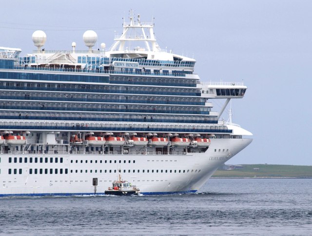
The String - Pilot Station Crown Princess <a href="https://www.geograph.org.uk/photo/2594173">HY4814 : The String and the Princess</a> leaving the String <a href="https://www.geograph.org.uk/photo/2593997">HY4814 : The String</a>.
Near here the Kirkwall Pilot disembarks, having navigated the liner safely through the narrows to more open water.
One can see, in the small hatchway, the Pilot awaiting his chances as the Pilot boat surges up beside the huge liner
See also here <a href="https://www.geograph.org.uk/photo/2594173">HY4814 : The String and the Princess</a>
The String - Pilot Station
Crown Princess HY4814 : The String and the Princess leaving the String HY4814 : The String. Near here the Kirkwall Pilot disembarks, having navigated the liner safely through the narrows to more open water. One can see, in the small hatchway, the Pilot awaiting his chances as the Pilot boat surges up beside the huge liner See also here HY4814 : The String and the Princess
The String The narrow stretch of water, beyond the buildings of Hatston and just in front of Shapinsay, is called the String <a href="https://www.geograph.org.uk/photo/2593997">HY4814 : The String</a>.
The String
The narrow stretch of water, beyond the buildings of Hatston and just in front of Shapinsay, is called the String HY4814 : The String.
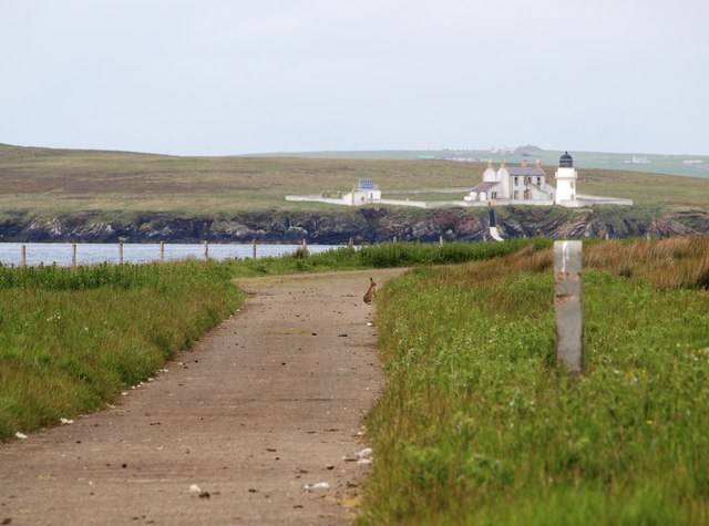
The Hare and The String Near the road's-end on the Head of Work, a hare awaits my next move.
The strip of water is called The String <a href="https://www.geograph.org.uk/photo/2593997">HY4814 : The String</a> and the 1892 Stevenson Lighthouse is on Helliar Holm (Shapinsay)
The Hare and The String
Near the road's-end on the Head of Work, a hare awaits my next move. The strip of water is called The String HY4814 : The String and the 1892 Stevenson Lighthouse is on Helliar Holm (Shapinsay)
The gate and Astor This gate marks the end of the tarmac. Beyond which the String <a href="https://www.geograph.org.uk/photo/2593997">HY4814 : The String</a> lies.
The liner Astor can be seen leaving Orkney Waters. The pilot boat follows and will collect the Pilot when his task is complete
The gate and Astor
This gate marks the end of the tarmac. Beyond which the String HY4814 : The String lies. The liner Astor can be seen leaving Orkney Waters. The pilot boat follows and will collect the Pilot when his task is complete
The String and the Princess Crown Princess <span class="nowrap"><a title="http://www.princess.com/learn/ships/kp/" rel="nofollow ugc noopener" href="http://www.princess.com/learn/ships/kp/">Link</a><img style="margin-left:2px;" alt="External link" title="External link - shift click to open in new window" src="https://s1.geograph.org.uk/img/external.png" width="10" height="10"/></span> leaving the String <a href="https://www.geograph.org.uk/photo/2594029">HY4714 : The String</a>, passes Saeva Ness <a href="https://www.geograph.org.uk/photo/2594116">HY4815 : Saeva Ness Light - Helliar Holm</a> lighthouse.
By any standards, she is enormous, having cabin capacity for well over 3000 passengers as well as a crew of over 1200.
The String and the Princess
Crown Princess LinkExternal link leaving the String HY4714 : The String, passes Saeva Ness HY4815 : Saeva Ness Light - Helliar Holm lighthouse. By any standards, she is enormous, having cabin capacity for well over 3000 passengers as well as a crew of over 1200.
The String,  Astor and Balfour Castle Astor enters The String <a href="https://www.geograph.org.uk/photo/2594029">HY4714 : The String</a>, having just left Kirwall.
She is guided by an onboard Pilot for a mile or two until she clears the sound.
In the background is Balfour Castle (Shapinsay)
<span class="nowrap"><a title="http://www.balfourcastle.co.uk/" rel="nofollow ugc noopener" href="http://www.balfourcastle.co.uk/">Link</a><img style="margin-left:2px;" alt="External link" title="External link - shift click to open in new window" src="https://s1.geograph.org.uk/img/external.png" width="10" height="10"/></span>
The String, Astor and Balfour Castle
Astor enters The String HY4714 : The String, having just left Kirwall. She is guided by an onboard Pilot for a mile or two until she clears the sound. In the background is Balfour Castle (Shapinsay) LinkExternal link
The Pier and Light house The pier on the southern end of Helliar Holm
The Pier and Light house
The pier on the southern end of Helliar Holm
Lighthouse at Saeva Ness, Helliar Holm, Shapinsay
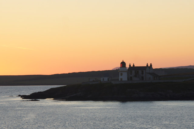
Saeva Ness Summer dusk on the approach to Kirkwall on the ferry from Aberdeen.
Saeva Ness
Summer dusk on the approach to Kirkwall on the ferry from Aberdeen.
Saeva Ness, Shapinsay, at sunset
Head of Work from the String, between Mainland and Shapinsay
Show me another place!

Bay of Work is located at Grid Ref: HY4713 (Lat: 59.001292, Lng: -2.9082523)

Unitary Authority: Orkney Islands

Police Authority: Highlands and Islands

What 3 Words

///handbag.scatter.wildfires. Near Kirkwall, Orkney Islands

Nearby Locations

Bay of Work Head of Work

Related Wikis

Thieves Holm

Thieves Holm is a small island in Orkney, Scotland. == Geography and geology == Thieves Holm is due north of Mainland, Orkney at the mouth of Kirkwall...

Helliar Holm

Helliar Holm is an uninhabited island off the coast of Shapinsay in the Orkney Islands, Scotland. It is home to a 42-foot-tall (13 m) lighthouse, which...

UHI Archaeology Institute

UHI Archaeology Institute is an academic department of the University of the Highlands and Islands in Scotland. It was founded in 2014, incorporating Orkney...

UHI Orkney

Orkney College (Scottish Gaelic: Colaiste Arcaibh) is a further and higher education college in Orkney, an archipelago in northern Scotland. It is an academic...

Nearby Amenities

Located within 500m of 59.001292,-2.9082523
Bay of Work
Natural: bay
Lat/Long: 59.0056332/-2.9070211
Power: pole
Lat/Long: 59.0033679/-2.9159202
Power: pole
Lat/Long: 59.0039181/-2.9152818
The data included in this document is from www.openstreetmap.org. The data is made available under ODbL.

Have you been to Bay of Work?

Leave your review of Bay of Work below (or comments, questions and feedback).