Little Wenham

Settlement in Suffolk Babergh

England

Little Wenham

Brook Lane & Bottle Bridge Cottages
Brook Lane & Bottle Bridge Cottages Credit: Geographer

The requested URL returned error: 429 Too Many Requests

If you have any feedback on the listing, please let us know in the comments section below.

Little Wenham Images

Images are sourced within 2km of 52.011453/1.030084 or Grid Reference TM0839. Thanks to Geograph Open Source API. All images are credited.

Brook Lane & Bottle Bridge Cottages
Brook Lane & bridleway
Bridleway to The Street & Upper Birches Off Brook Lane
Bridleway to The Street & Upper Birches
Off Brook Lane
Esso Service Station on A12 north near Capel St Mary
The A12, Capel St Mary I've been here before. <a title="https://www.geograph.org.uk/photo/5377066" href="https://www.geograph.org.uk/photo/5377066">Link</a>
The A12, Capel St Mary
I've been here before. Link
The A12, Capel St Mary
"They Came in Our Hour of Need" Raydon Airfield Memorial, the monument remembers the members of the USAAF 833 & 862 Aviation Engineering Battalions and 353,357,358 Fighter Groups who served at Raydon Airfield in WW2. The plaque says "They Came in Our Hour of Need". It stands at the end of one of the main runways. The photo was taken looking southwest. The remains of the airscrews are from P51 Mustang on the Right and a P47 thunderbolt on the left. Both types operated from Raydon.
"They Came in Our Hour of Need"
Raydon Airfield Memorial, the monument remembers the members of the USAAF 833 & 862 Aviation Engineering Battalions and 353,357,358 Fighter Groups who served at Raydon Airfield in WW2. The plaque says "They Came in Our Hour of Need". It stands at the end of one of the main runways. The photo was taken looking southwest. The remains of the airscrews are from P51 Mustang on the Right and a P47 thunderbolt on the left. Both types operated from Raydon.
St. Mary's church, Capel St. Mary, Suffolk This is a mainly 15th century church.  At one time it had a spire. Inside, there is a fine hammerbeam roof.
St. Mary's church, Capel St. Mary, Suffolk
This is a mainly 15th century church. At one time it had a spire. Inside, there is a fine hammerbeam roof.
St. John's church, Great Wenham, Suffolk This mainly 14th century church has a fine tower with nice flushwork decoration.
St. John's church, Great Wenham, Suffolk
This mainly 14th century church has a fine tower with nice flushwork decoration.
All Saints church, Little Wenham, Suffolk This church, seen across a field, dates from 1300 and stands close to the 13th century Little Wenham Hall, which is private. The brick built upper stage of the tower is Tudor.
All Saints church, Little Wenham, Suffolk
This church, seen across a field, dates from 1300 and stands close to the 13th century Little Wenham Hall, which is private. The brick built upper stage of the tower is Tudor.
Footpath that runs alongside Acacia Farm
Wenham Place, Great Wenham, Suffolk
Public footpath at Great Wenham
Allotments along Pound Lane
Capel St. Mary, Suffolk This is the view at the end of Pound Lane by St. Mary's church.
Capel St. Mary, Suffolk
This is the view at the end of Pound Lane by St. Mary's church.
Disused railway bridge over footpath This bridge used to carry the Hadleigh branch line that left the London-Norwich line north of Bentley. Some sections are plainly visible and some have been ploughed in but few are walkable, being on private land
Disused railway bridge over footpath
This bridge used to carry the Hadleigh branch line that left the London-Norwich line north of Bentley. Some sections are plainly visible and some have been ploughed in but few are walkable, being on private land
Lane leading southwest from Great Wenham Church In a grid largely devoid of features, this lane or track provides an attractive walk between trees and into the cornfields at the heart of this grid square
Lane leading southwest from Great Wenham Church
In a grid largely devoid of features, this lane or track provides an attractive walk between trees and into the cornfields at the heart of this grid square
Clay Hall (behind a ripe crop of oil seed rape) The footpath passes close to Clay Hall and through the farmyard which has a pond with ducks
Clay Hall (behind a ripe crop of oil seed rape)
The footpath passes close to Clay Hall and through the farmyard which has a pond with ducks
Show me another place!

Little Wenham is located at Grid Ref: TM0839 (Lat: 52.011453, Lng: 1.030084)

Administrative County: Suffolk

District: Babergh

Police Authority: Suffolk

What 3 Words

///glue.woven.bookshop. Near Capel St Mary, Suffolk

Related Wikis

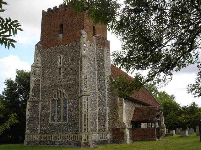
All Saints Church, Little Wenham

All Saints Church is a redundant Anglican church in the village of Little Wenham, Suffolk, England. It is recorded in the National Heritage List for England...

Little Wenham

Little Wenham is a small village in Suffolk, England. It is part of the civil parish of Wenham Parva – the ancient name for Little Wenham) within Babergh...

Wenham Parva

Wenham Parva is a civil parish in Suffolk, England. It covers the village of Little Wenham (whose ancient name it takes) and the hamlet of Wenham Grange...

Wenham Magna

Wenham Magna, also known as Great Wenham, is a village and a civil parish in the Babergh district of Suffolk in eastern England. The parish also contains...

Nearby Amenities

Located within 500m of 52.011453,1.030084
Little Wenham
Place: village
Source: NLS - OS 1:25k 1st Series 1937-61
Wikidata: Q11761991
Lat/Long: 52.0104559/1.0337867
Power: pole
Lat/Long: 52.0101223/1.0289077
Power: pole
Lat/Long: 52.0106843/1.0277541
Material: wood
Power: pole
Lat/Long: 52.0072351/1.0312103
Material: wood
Power: pole
Lat/Long: 52.0072816/1.0308494
Material: wood
Power: pole
Lat/Long: 52.007133/1.0318874
Power: pole
Lat/Long: 52.0082942/1.0326404
Power: pole
Lat/Long: 52.0077704/1.0336992
Power: pole
Lat/Long: 52.0089359/1.0313429
The data included in this document is from www.openstreetmap.org. The data is made available under ODbL.

Have you been to Little Wenham?

Leave your review of Little Wenham below (or comments, questions and feedback).