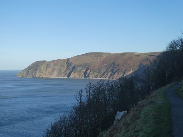
Lynmouth Bay

Bay in Devon

England

Lynmouth Bay

Lynton : Foreland Point Looking across towards Foreland Point. The coastline of Wales can be seen in the distance.
Lynton : Foreland Point Credit: Lewis Clarke

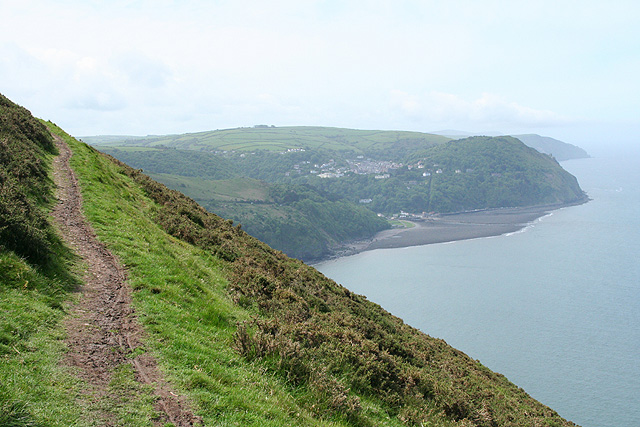
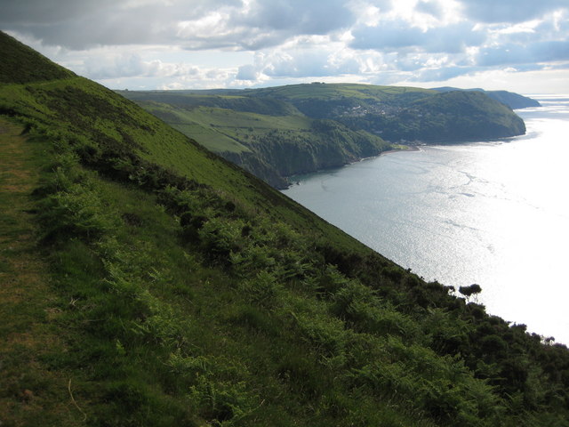
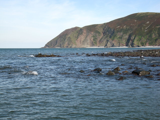
Lynmouth Bay is a picturesque coastal area located in the county of Devon, England. Situated on the southern edge of Exmoor National Park, the bay is renowned for its stunning natural beauty, rugged cliffs, and pristine sandy beaches. It is a popular destination among tourists and locals alike, offering a perfect combination of breathtaking landscapes and charming seaside villages.

The bay is formed by the confluence of the East Lyn River and the West Lyn River, which flow through the towns of Lynton and Lynmouth before reaching the sea. This unique geographical feature adds to the bay's allure, providing visitors with a captivating blend of river, woodland, and coastal scenery. The river estuary also serves as a habitat for a diverse range of wildlife, including otters, salmon, and rare bird species.

Lynmouth Bay is blessed with a mild climate, making it an ideal spot for outdoor activities such as hiking, birdwatching, and water sports. The South West Coast Path, a long-distance trail that stretches along the region's coastline, offers breathtaking views of the bay and its surroundings.

The bay is also steeped in history, with Lynmouth being famous for its connection to the Victorian era. The town was severely damaged by a devastating flood in 1952, but it has since been rebuilt and now boasts a mix of traditional and modern architecture.

In summary, Lynmouth Bay is a captivating destination that offers visitors a perfect blend of natural beauty, outdoor pursuits, and historical charm. Its idyllic coastal setting and rich heritage make it a must-visit location for anyone exploring Devon's stunning coastline.

If you have any feedback on the listing, please let us know in the comments section below.

Lynmouth Bay Images

Images are sourced within 2km of 51.236044/-3.8192379 or Grid Reference SS7350. Thanks to Geograph Open Source API. All images are credited.

Lynton : Foreland Point Looking across towards Foreland Point. The coastline of Wales can be seen in the distance.
Lynton : Foreland Point
Looking across towards Foreland Point. The coastline of Wales can be seen in the distance.
Lynmouth Bay and Foreland Point
Lynton : Foreland Point Looking across towards Foreland Point.
Lynton : Foreland Point
Looking across towards Foreland Point.
Trig pillar on Butter Hill At the peak of Butter Hill is a small telecommunications station and a triangulation pillar.
Trig pillar on Butter Hill
At the peak of Butter Hill is a small telecommunications station and a triangulation pillar.
Butter Hill flush bracket The trig pillar is identified by the flush bracket S5435, with the sight holes at least open to the elements on top of the hill. The station is a third order installation, levelled in 1971.
Butter Hill flush bracket
The trig pillar is identified by the flush bracket S5435, with the sight holes at least open to the elements on top of the hill. The station is a third order installation, levelled in 1971.
Surveying from Butter Hill The triangulation pillar sits on top of Butter Hill; it's clear why as it has great views across Lynmouth Bay and the highlands behind it.
Surveying from Butter Hill
The triangulation pillar sits on top of Butter Hill; it's clear why as it has great views across Lynmouth Bay and the highlands behind it.
Sunset on Butter Hill Although it is over 300m above the steep sea cliffs, the small telecommunications station seems to be rather uninhabited.
Sunset on Butter Hill
Although it is over 300m above the steep sea cliffs, the small telecommunications station seems to be rather uninhabited.
Countisbury: South West Coast Path by Butter Hill Looking west-south-west towards Lynton and Lynmouth. The track of the cliff railway linking the two communities is visible as a vertical cut through the wooded slopes by the coast
Countisbury: South West Coast Path by Butter Hill
Looking west-south-west towards Lynton and Lynmouth. The track of the cliff railway linking the two communities is visible as a vertical cut through the wooded slopes by the coast
Countisbury: Exmoor mare and foal By Great Red on the public footpath leading to the Foreland and Caddow Combe. Looking north east
Countisbury: Exmoor mare and foal
By Great Red on the public footpath leading to the Foreland and Caddow Combe. Looking north east
Butter Hill TV Relay Station,Trig pillar and Exmoor Ponies The hut may be used as a simple shelter by stranded hikers.
Butter Hill TV Relay Station,Trig pillar and Exmoor Ponies
The hut may be used as a simple shelter by stranded hikers.
Landslide near Foreland Point Lynton and Lynmouth in the background
Landslide near Foreland Point
Lynton and Lynmouth in the background
The Gun Caverns. One of five large caves on the beach in this square.
<span class="nowrap"><a title="http://www.flickr.com/photos/exmoor_climber" rel="nofollow ugc noopener" href="http://www.flickr.com/photos/exmoor_climber">Link</a><img style="margin-left:2px;" alt="External link" title="External link - shift click to open in new window" src="https://s1.geograph.org.uk/img/external.png" width="10" height="10"/></span>
The Gun Caverns.
One of five large caves on the beach in this square. LinkExternal link
Coddow Slip Gully One of the many long gully routes on the Exmoor Coast.
<span class="nowrap"><a title="http://www.flickr.com/photos/exmoor_climber" rel="nofollow ugc noopener" href="http://www.flickr.com/photos/exmoor_climber">Link</a><img style="margin-left:2px;" alt="External link" title="External link - shift click to open in new window" src="https://s1.geograph.org.uk/img/external.png" width="10" height="10"/></span>
Coddow Slip Gully
One of the many long gully routes on the Exmoor Coast. LinkExternal link
Foreland Point from Lynton Evening sun illuminates Big Red and the other landslips on the coastline as it juts out towards Foreland Point, whose tip is in <a href="https://www.geograph.org.uk/gridref/SS7551">SS7551</a>.
Foreland Point from Lynton
Evening sun illuminates Big Red and the other landslips on the coastline as it juts out towards Foreland Point, whose tip is in SS7551.
The South West Coast Path, Butter Hill The South West Coast Path contouring below the summit of Butter Hill, Lynton and Lynmouth can be seen allow the coast in the background.
The South West Coast Path, Butter Hill
The South West Coast Path contouring below the summit of Butter Hill, Lynton and Lynmouth can be seen allow the coast in the background.
Butter Hill Butter Hill viewed from the South West Coast Path which contours below the summit.
Butter Hill
Butter Hill viewed from the South West Coast Path which contours below the summit.
View over Great Red The huge landslip known as Great Red is in the centre of the photo.
View over Great Red
The huge landslip known as Great Red is in the centre of the photo.
Lyn Mouth rocks These rocks are only visible when there is a very low tide. The photo was taken at 16:03 BST during a low autumn tide. Foreland Point is clearly visible in the distance with the gully known as Great Red showing between the cliffs in the centre.
Lyn Mouth rocks
These rocks are only visible when there is a very low tide. The photo was taken at 16:03 BST during a low autumn tide. Foreland Point is clearly visible in the distance with the gully known as Great Red showing between the cliffs in the centre.
Show me another place!

Lynmouth Bay is located at Grid Ref: SS7350 (Lat: 51.236044, Lng: -3.8192379)

Administrative County: Devon

Police Authority: Devon and Cornwall

What 3 Words

///interacts.capillary.other. Near Lynton, Devon

Nearby Locations

Lynmouth Bay

Related Wikis

East Lyn River

The East Lyn is a river which rises high in Exmoor, in the English county of Somerset. It flows through the East Lyn Valley in Devon. == Watercourse... ==

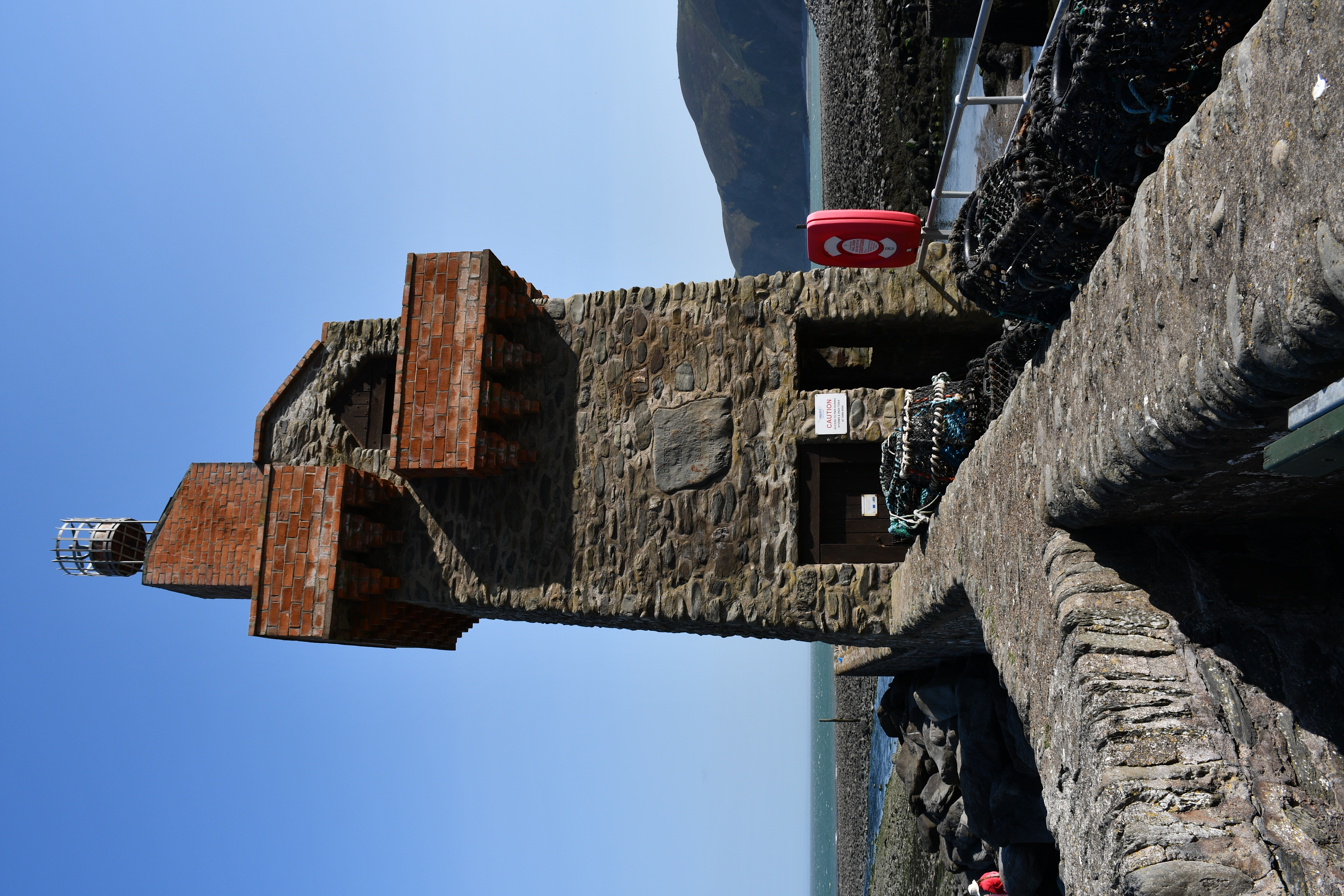
Rhenish Tower, Lynmouth

The Rhenish Tower is a building on the pier of Lynmouth, in Devon, England, originally built in the 19th century. It is Grade II listed. The tower has...
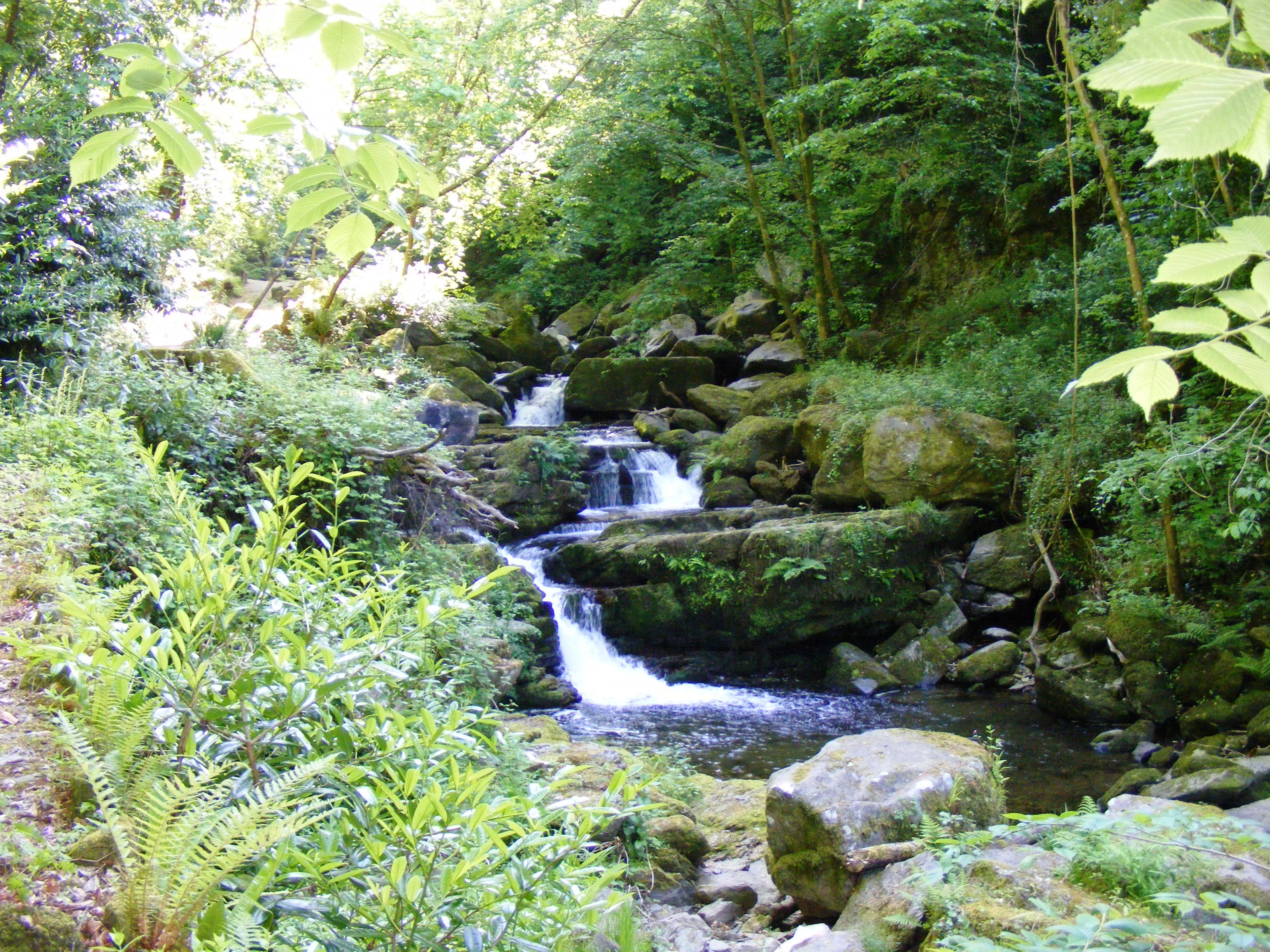
West Lyn River

The West Lyn is a river in England which rises high in Exmoor, Somerset, and joins the East Lyn at Lynmouth in Devon. The upper reaches have been designated...

Lynmouth Lifeboat Station

Lynmouth Lifeboat Station was the base for Royal National Lifeboat Institution (RNLI) search and rescue operations at Lynmouth, Devon in England from 1869...

Nearby Amenities

Located within 500m of 51.236044,-3.8192379
Source: PGS
Lat/Long: 51.2321033/-3.8162284
Source: PGS
Lat/Long: 51.2320611/-3.8164716
Source: PGS
Lat/Long: 51.2322992/-3.8185365
Source: PGS
Lat/Long: 51.2323181/-3.8192659
Source: PGS
Lat/Long: 51.2317273/-3.8207228
Source: PGS
Lat/Long: 51.2325131/-3.8206019
Source: PGS
Lat/Long: 51.2325331/-3.8206264
Source: PGS
Lat/Long: 51.232701/-3.820607
Source: PGS
Lat/Long: 51.2328119/-3.8206307
Source: PGS
Lat/Long: 51.2329363/-3.8207183
Source: PGS
Lat/Long: 51.2338517/-3.8233729
Source: PGS
Lat/Long: 51.2324292/-3.8198736
Source: PGS
Lat/Long: 51.2324534/-3.8204043
The data included in this document is from www.openstreetmap.org. The data is made available under ODbL.

Have you been to Lynmouth Bay?

Leave your review of Lynmouth Bay below (or comments, questions and feedback).