Hazel Bushes Bay

Bay in Devon

England

Hazel Bushes Bay

The South West Coast Path
The South West Coast Path Credit: Tim Glover

The requested URL returned error: 429 Too Many Requests

If you have any feedback on the listing, please let us know in the comments section below.

Hazel Bushes Bay Images

Images are sourced within 2km of 51.205348/-4.1462195 or Grid Reference SS5047. Thanks to Geograph Open Source API. All images are credited.

The South West Coast Path
Sign at Women's Institute Car Park at Lee
Old Maid's Cottage, Lee, North Devon
The village hall at Lee Also providing tourist information
The village hall at Lee
Also providing tourist information
Footpath and track to Whitestone Farm
Lincombe House
Lincombe House
High Banks, Lincombe
St Matthew and St Wardrede in the village of Lee Detail of Southern wall
St Matthew and St Wardrede in the village of Lee
Detail of Southern wall
War Memorial, Lee Outside the Parish Church of St. Matthew and St. Wardrede built in 1833-34
War Memorial, Lee
Outside the Parish Church of St. Matthew and St. Wardrede built in 1833-34
Outside the church of St Matthew and St Wardrede in the village of Lee
Church of St Matthew and St Wardrede in the village of Lee
Old Maid's Cottage, Lee, North Devon
The Old Post Office, Lee, North Devon
North Devon : Coastal Scenery Looking towards Flat Point on the North Devon coastline.
North Devon : Coastal Scenery
Looking towards Flat Point on the North Devon coastline.
North Devon : Coastal Scenery Looking across the North Devon coastline and towards Flat Point.
North Devon : Coastal Scenery
Looking across the North Devon coastline and towards Flat Point.
North Devon : Coastal Scenery Looking towards Sheepstor on the North Devon coastline.
North Devon : Coastal Scenery
Looking towards Sheepstor on the North Devon coastline.
North Devon : Coastal Scenery Looking across the North Devon coastline.
North Devon : Coastal Scenery
Looking across the North Devon coastline.
North Devon : Coastal Scenery Looking across the North Devon coastline.
North Devon : Coastal Scenery
Looking across the North Devon coastline.
Show me another place!

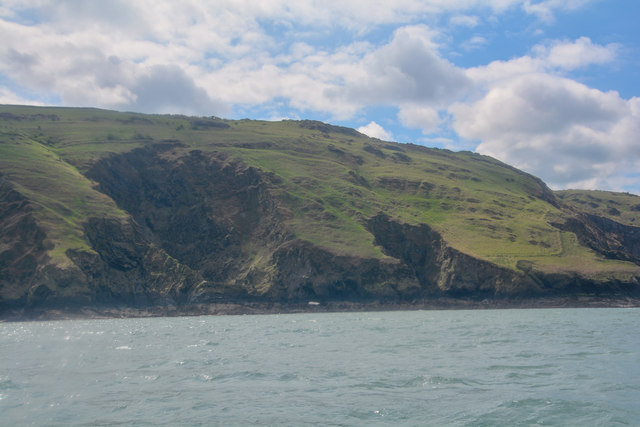
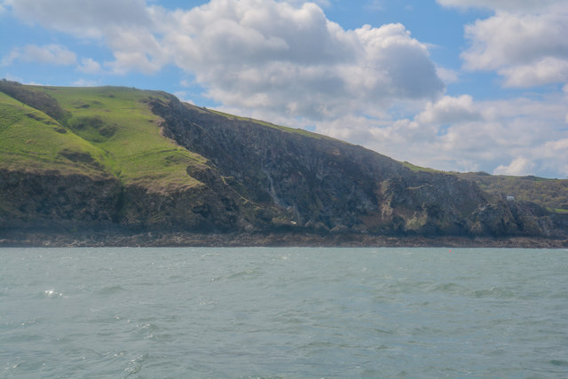
Hazel Bushes Bay is located at Grid Ref: SS5047 (Lat: 51.205348, Lng: -4.1462195)

Administrative County: Devon

Police Authority: Devon and Cornwall

What 3 Words

///reserves.surface.screeches. Near Ilfracombe, Devon

Related Wikis

The Torrs

The Torrs are a Local Nature Reserve and one of the four main hills in the North Devon coastal town of Ilfracombe. The Park originally was designed in...

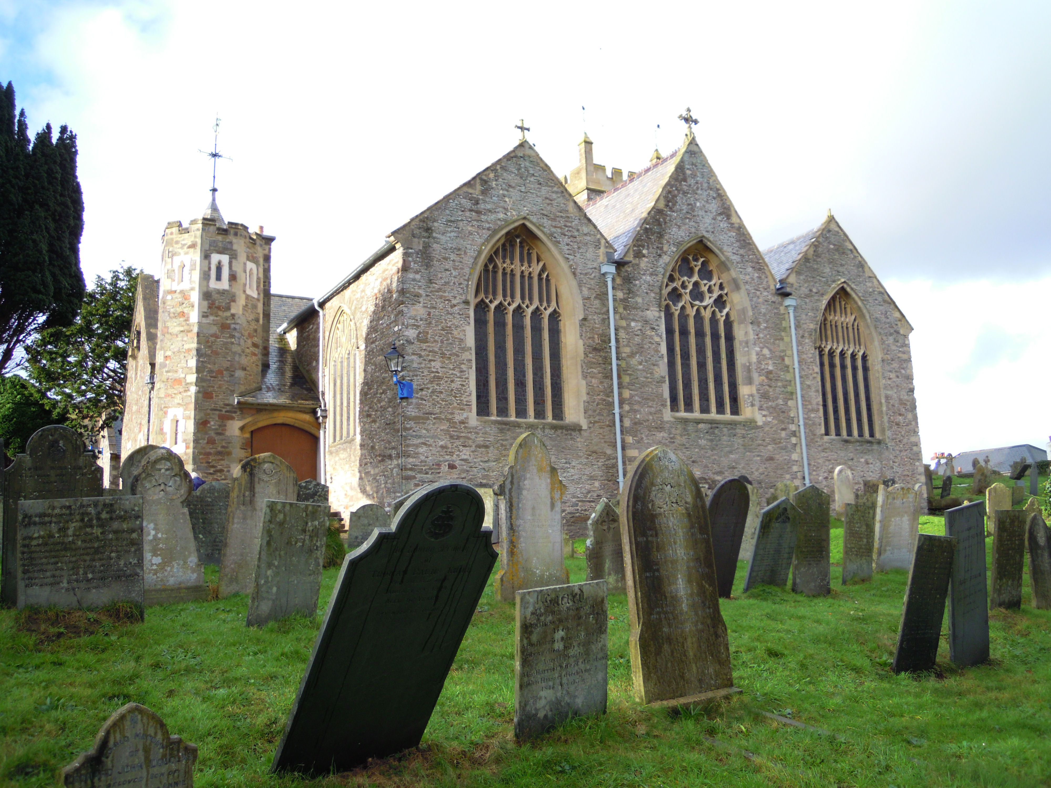
Holy Trinity Church, Ilfracombe

The Church of the Holy Trinity is the Anglican parish church for Ilfracombe in Devon. The building has been a Grade I listed building since 1951 and comes...

Ilfracombe railway station (England)

Ilfracombe railway station was the terminus of the Ilfracombe branch line in north Devon, England. The line was opened as the Barnstaple and Ilfracombe...

Old Town Hall, Ilfracombe

The Old Town Hall is a former municipal building in the High Street in Ilfracombe, Devon, England. The structure, which currently operates as gym, is a...

Nearby Amenities

Located within 500m of 51.205348,-4.1462195
Source: PGS
Lat/Long: 51.2074136/-4.1400871
Source: PGS
Lat/Long: 51.2073501/-4.1403254
Source: PGS
Lat/Long: 51.2073462/-4.1406452
Source: PGS
Lat/Long: 51.2075144/-4.141113
Source: PGS
Lat/Long: 51.207411/-4.142716
Source: PGS
Lat/Long: 51.2070356/-4.1428238
Source: PGS
Lat/Long: 51.2067134/-4.1444122
Source: PGS
Lat/Long: 51.2065089/-4.1444844
Source: PGS
Lat/Long: 51.2060676/-4.145048
Source: PGS
Lat/Long: 51.2058973/-4.1450361
Source: PGS
Lat/Long: 51.2057046/-4.1457002
Source: PGS
Lat/Long: 51.2056579/-4.1457326
Source: PGS
Lat/Long: 51.2050774/-4.1465059
Source: PGS
Lat/Long: 51.2048111/-4.1464748
Source: PGS
Lat/Long: 51.2046939/-4.1465793
Source: PGS
Lat/Long: 51.2047092/-4.1468828
Source: PGS
Lat/Long: 51.204548/-4.1478361
Source: PGS
Lat/Long: 51.2044589/-4.1479277
Source: PGS
Lat/Long: 51.2042861/-4.1482151
Source: PGS
Lat/Long: 51.2042408/-4.1483299
Source: PGS
Lat/Long: 51.2043293/-4.1488426
Source: PGS
Lat/Long: 51.2042719/-4.1493198
Source: PGS
Lat/Long: 51.2045861/-4.1504444
Source: PGS
Lat/Long: 51.2044749/-4.1511354
Source: PGS
Lat/Long: 51.2042207/-4.1523948
Source: PGS
Lat/Long: 51.2044918/-4.1532272
Barrier: kissing_gate
Lat/Long: 51.2021768/-4.146304
Breakneck Point
Place: locality
Lat/Long: 51.207161/-4.1440473
Brandy Cove Point
Place: locality
Lat/Long: 51.2077407/-4.1419963
Source: PGS
Lat/Long: 51.2041181/-4.1498692
Source: PGS
Lat/Long: 51.2034882/-4.148646
Source: PGS
Lat/Long: 51.2033553/-4.1516865
Source: PGS
Lat/Long: 51.2036958/-4.1513108
Source: PGS
Lat/Long: 51.2043924/-4.1502916
Source: PGS
Lat/Long: 51.2037279/-4.1483724
Source: PGS
Lat/Long: 51.2036712/-4.1478556
Source: PGS
Lat/Long: 51.2043305/-4.1505425
Source: PGS
Lat/Long: 51.2040016/-4.1468228
Source: PGS
Lat/Long: 51.2039137/-4.1456139
Source: PGS
Lat/Long: 51.2043725/-4.1450804
Source: PGS
Lat/Long: 51.2051463/-4.144305
Source: PGS
Lat/Long: 51.2039075/-4.1507874
Source: PGS
Lat/Long: 51.2057078/-4.1434747
Source: PGS
Lat/Long: 51.2060801/-4.1430384
Source: PGS
Lat/Long: 51.2066757/-4.1427865
Source: PGS
Lat/Long: 51.2060791/-4.1421321
Source: PGS
Lat/Long: 51.20638/-4.1415554
Source: PGS
Lat/Long: 51.206295/-4.1394344
Source: PGS
Lat/Long: 51.2063552/-4.1400036
Source: PGS
Lat/Long: 51.2064822/-4.1405497
Source: PGS
Lat/Long: 51.2065894/-4.1416944
Source: PGS
Lat/Long: 51.2071473/-4.1416534
Source: PGS
Lat/Long: 51.2073339/-4.1411709
Brandy
Natural: bay
Source: OS_OpenData_StreetView
Lat/Long: 51.2070115/-4.1423598
Hazel Bushes Bay
Natural: bay
Source: OS_OpenData_StreetView
Lat/Long: 51.2054729/-4.1471229
Fixme: stile, gate or entrance?
Lat/Long: 51.2015015/-4.1491185
Source: PGS
Lat/Long: 51.2048253/-4.1432284
Source: PGS
Lat/Long: 51.2050833/-4.1430314
Source: PGS
Lat/Long: 51.2054886/-4.1424873
Source: PGS
Lat/Long: 51.2057741/-4.1421792
Source: PGS
Lat/Long: 51.2059512/-4.1412594
Source: PGS
Lat/Long: 51.2062201/-4.1412594
The data included in this document is from www.openstreetmap.org. The data is made available under ODbL.

Have you been to Hazel Bushes Bay?

Leave your review of Hazel Bushes Bay below (or comments, questions and feedback).