Porth Tywodog

Bay in Anglesey

Wales

Porth Tywodog

Navigation markers The Coal Rock Beacons known locally as the White Ladies.
<span class="nowrap"><a title="http://en.wikipedia.org/wiki/Carmel_Head" rel="nofollow ugc noopener" href="http://en.wikipedia.org/wiki/Carmel_Head">Link</a><img style="margin-left:2px;" alt="External link" title="External link - shift click to open in new window" src="https://s1.geograph.org.uk/img/external.png" width="10" height="10"/></span>
Navigation markers Credit: Chris McAuley

The requested URL returned error: 429 Too Many Requests

If you have any feedback on the listing, please let us know in the comments section below.

Porth Tywodog Images

Images are sourced within 2km of 53.40637/-4.5364013 or Grid Reference SH3192. Thanks to Geograph Open Source API. All images are credited.
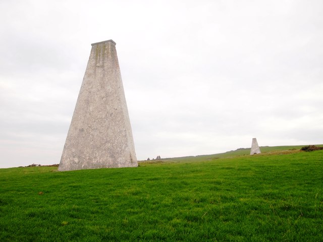
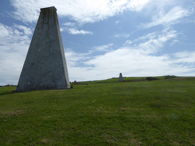
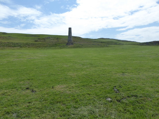
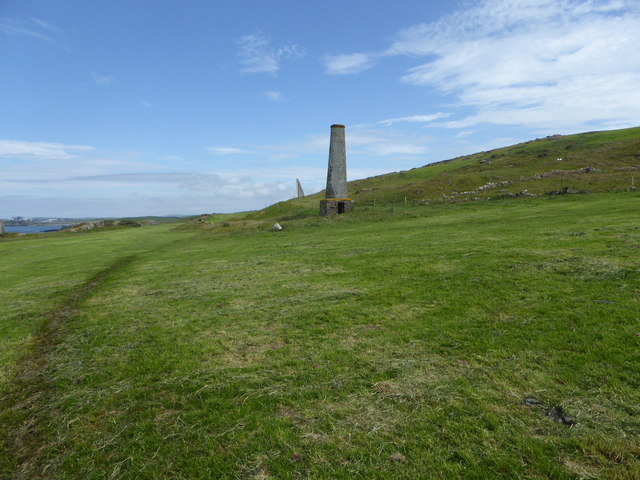
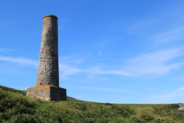
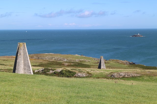
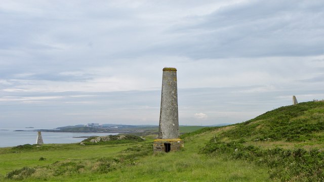
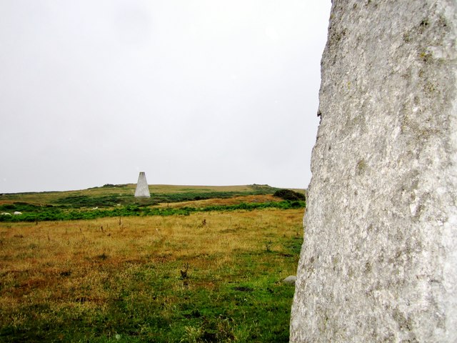
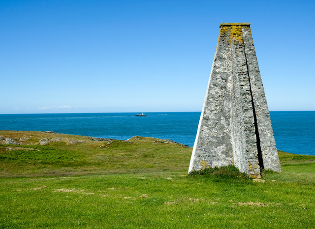
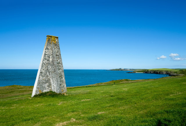
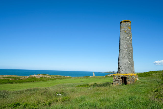
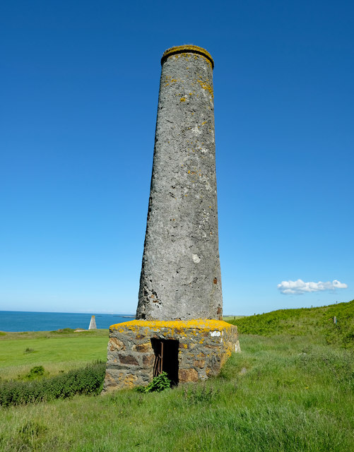
Navigation markers The Coal Rock Beacons known locally as the White Ladies.
<span class="nowrap"><a title="http://en.wikipedia.org/wiki/Carmel_Head" rel="nofollow ugc noopener" href="http://en.wikipedia.org/wiki/Carmel_Head">Link</a><img style="margin-left:2px;" alt="External link" title="External link - shift click to open in new window" src="https://s1.geograph.org.uk/img/external.png" width="10" height="10"/></span>
Navigation markers
The Coal Rock Beacons known locally as the White Ladies. LinkExternal link
Anglesey Coast Path at Carmel Head
Coal Rock Pilot Beacons, Carmel Head Also known as the 'White Ladies'.  They were erected by Trinity House in the 1830's as an aid to navigation into the harbour at Holyhead and probably used in conjuction with the marker on West Mouse
Coal Rock Pilot Beacons, Carmel Head
Also known as the 'White Ladies'. They were erected by Trinity House in the 1830's as an aid to navigation into the harbour at Holyhead and probably used in conjuction with the marker on West Mouse
Carmel Head
Carmel Head
White Lady beacon The beacons were erected on Carmel Head by Trinity House in the 1830's as an aid to navigation into the harbour at Holyhead and probably used in conjuction with the marker on West Mouse.
White Lady beacon
The beacons were erected on Carmel Head by Trinity House in the 1830's as an aid to navigation into the harbour at Holyhead and probably used in conjuction with the marker on West Mouse.
Chimney on Carmel Head The remains of copper workings on the headland.
Chimney on Carmel Head
The remains of copper workings on the headland.
Chimney, Carmel Head The remains of copper workings on the headland. Just to the left of the chimney is one of the White Ladies, marker to aid navigation at sea.
Chimney, Carmel Head
The remains of copper workings on the headland. Just to the left of the chimney is one of the White Ladies, marker to aid navigation at sea.
Disused Chimney
Disused Chimney
Navigation Markers Maritime Navigation Markers, with West Mouse islet in the distance.
Navigation Markers
Maritime Navigation Markers, with West Mouse islet in the distance.
Monuments old and new In the centre of the photo is the chimney associated with a short lived 19thC copper mine. Further on are two of the 'white ladies' navigation markers, whilst away in the far distance is the now decommissioned nuclear power station at Wylfa.
Monuments old and new
In the centre of the photo is the chimney associated with a short lived 19thC copper mine. Further on are two of the 'white ladies' navigation markers, whilst away in the far distance is the now decommissioned nuclear power station at Wylfa.
The 'white ladies' From this angle the white ladies look rather grey. These two navigation markers line up with a third one [just visible] on the islet of West Mouse and were erected in the 1860's to help guide shipping past dangerous reefs offshore.
The 'white ladies'
From this angle the white ladies look rather grey. These two navigation markers line up with a third one [just visible] on the islet of West Mouse and were erected in the 1860's to help guide shipping past dangerous reefs offshore.
A White Lady and West Mouse One of the two large beacons known as the 'White Ladies'constructed in the 1860s. The beacons line up with a similar tower on the small island of West Mouse and acted as a guide for shipping negotiating Carmel Head.

Source: Walking the Isle of Anglesey Coastal Path, Official Guide by Carl Rogers.
A White Lady and West Mouse
One of the two large beacons known as the 'White Ladies'constructed in the 1860s. The beacons line up with a similar tower on the small island of West Mouse and acted as a guide for shipping negotiating Carmel Head. Source: Walking the Isle of Anglesey Coastal Path, Official Guide by Carl Rogers.
The Anglesey Coastal Path passing a White Lady The Anglesey Coastal Path passing a White Lady near Carmel Head. In the far distance is Wylfa Nuclear Power Station at Cemlyn Bay.

This is one of two large beacons known as the 'White Ladies' constructed in the 1860s. The beacons line up with a similar tower on the small island of West Mouse and acted as a guide for shipping negotiating Carmel Head.

Source: Walking the Isle of Anglesey Coastal Path, Official Guide by Carl Rogers.
The Anglesey Coastal Path passing a White Lady
The Anglesey Coastal Path passing a White Lady near Carmel Head. In the far distance is Wylfa Nuclear Power Station at Cemlyn Bay. This is one of two large beacons known as the 'White Ladies' constructed in the 1860s. The beacons line up with a similar tower on the small island of West Mouse and acted as a guide for shipping negotiating Carmel Head. Source: Walking the Isle of Anglesey Coastal Path, Official Guide by Carl Rogers.
Disused Chimney at Carmel Head Copper Mine The small copper mine at Carmel Head was originally established in the 18th century. The mine was sold in the 1860s and abandoned
soon after because of poor yields.

Source: Natural Resources Wales
Disused Chimney at Carmel Head Copper Mine
The small copper mine at Carmel Head was originally established in the 18th century. The mine was sold in the 1860s and abandoned soon after because of poor yields. Source: Natural Resources Wales
View towards the Skerries from Carmel Head View towards the Skerries from Carmel Head.
View towards the Skerries from Carmel Head
View towards the Skerries from Carmel Head.
Coastline at Porth y Wig The Skerries on the horizon.
Coastline at Porth y Wig
The Skerries on the horizon.
The approach to Bryn Aber Bryn Aber, the former home of Vivian Hewitt, was put up for sale a few years ago and the particulars <span class="nowrap"><a title="https://media.onthemarket.com/properties/3258764/doc_0_4.pdf" rel="nofollow ugc noopener" href="https://media.onthemarket.com/properties/3258764/doc_0_4.pdf">Link</a><img style="margin-left:2px;" alt="External link" title="External link - shift click to open in new window" src="https://s1.geograph.org.uk/img/external.png" width="10" height="10"/></span> describe what was on offer inside those forbidding walls: 'immense enclosed rear gardens' (a long and very high wall can be seen surrounding them), 'ample off road parking' (in those immense gardens), 'advantage of no onward chain' (the house had been unoccupied for some time) but 'in need of a great deal of internal and external attention'.  It is in the process of being converted to a holiday let.

Across the bay can be seen the former Wylfa nuclear power station.
The approach to Bryn Aber
Bryn Aber, the former home of Vivian Hewitt, was put up for sale a few years ago and the particulars LinkExternal link describe what was on offer inside those forbidding walls: 'immense enclosed rear gardens' (a long and very high wall can be seen surrounding them), 'ample off road parking' (in those immense gardens), 'advantage of no onward chain' (the house had been unoccupied for some time) but 'in need of a great deal of internal and external attention'. It is in the process of being converted to a holiday let. Across the bay can be seen the former Wylfa nuclear power station.
Show me another place!

Porth Tywodog is located at Grid Ref: SH3192 (Lat: 53.40637, Lng: -4.5364013)

Unitary Authority: Isle of Anglesey

Police Authority: North Wales

What 3 Words

///dislodge.hours.station. Near Cemaes Bay, Isle of Anglesey

Nearby Locations

Porth Tywodog

Related Wikis

Henborth

Henborth is a Site of Special Scientific Interest (or SSSI) in Anglesey, North Wales. It has been designated as a Site of Special Scientific Interest since...

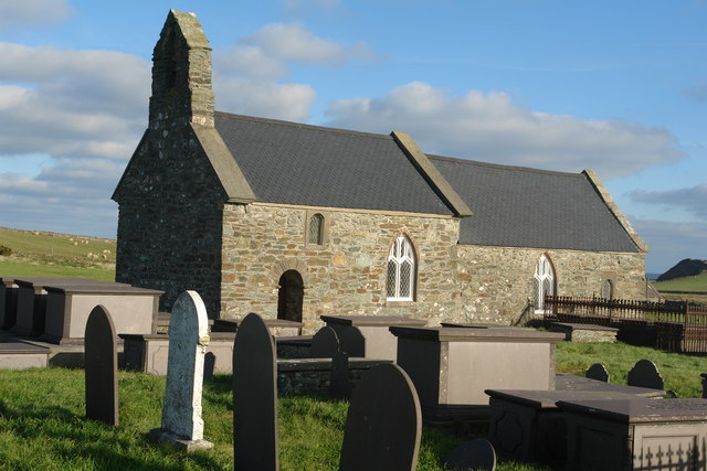
St Rhwydrus's Church, Llanrhwydrus

St Rhwydrus's Church is a medieval church in the village of Cemlyn on the Isle of Anglesey, Wales. The building dates from the mid-12th century and underwent...

Caerau, Anglesey

Caerau, Cylch-y-Garn is an area in the community of Cylch-y-Garn, Isle of Anglesey, Wales. == Caerau Mansion == There is a group of buildings at Caerau...

Cemlyn Bay and lagoon

Cemlyn Bay is a bay on the northwest coast of Anglesey, North Wales, approximately 2.5 km west of Wylfa nuclear power station, within the community of...

Nearby Amenities

Located within 500m of 53.40637,-4.5364013
Source: PGS
Lat/Long: 53.4063494/-4.5290527
Source: PGS
Lat/Long: 53.4060458/-4.5298826
Source: PGS
Lat/Long: 53.4068346/-4.5310342
Source: PGS
Lat/Long: 53.4068439/-4.5317019
Source: PGS
Lat/Long: 53.4074089/-4.532636
Source: PGS
Lat/Long: 53.4073471/-4.5329098
Source: PGS
Lat/Long: 53.4069601/-4.5328245
Source: PGS
Lat/Long: 53.4065365/-4.5338256
Source: PGS
Lat/Long: 53.4065287/-4.5350697
Source: PGS
Lat/Long: 53.4063286/-4.5353107
Source: PGS
Lat/Long: 53.4061258/-4.5363975
Source: PGS
Lat/Long: 53.4059623/-4.5378068
Source: PGS
Lat/Long: 53.4060804/-4.5385097
Created By: almien_coastlines
Source: PGS
Lat/Long: 53.4060573/-4.5395849
Source: PGS
Lat/Long: 53.4061133/-4.5406081
Source: PGS
Lat/Long: 53.406277/-4.5416445
Source: PGS
Lat/Long: 53.406238/-4.5419198
Source: PGS
Lat/Long: 53.4060551/-4.5433883
Hen Borth
Created By: Potlatch 0.8b
Place: locality
Source: npe
Lat/Long: 53.4069953/-4.5297466
Barrier: kissing_gate
Lat/Long: 53.4056536/-4.5373082
Barrier: kissing_gate
Lat/Long: 53.4060533/-4.5352613
The data included in this document is from www.openstreetmap.org. The data is made available under ODbL.

Have you been to Porth Tywodog?

Leave your review of Porth Tywodog below (or comments, questions and feedback).