Bossiney Haven

Bay in Cornwall

England

Bossiney Haven

Long Island View from coastal path at Rocky Valley Trethevey
Long Island Credit: norman griffin

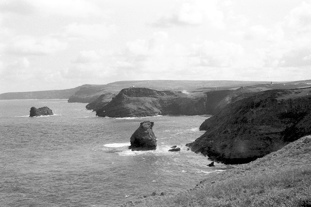
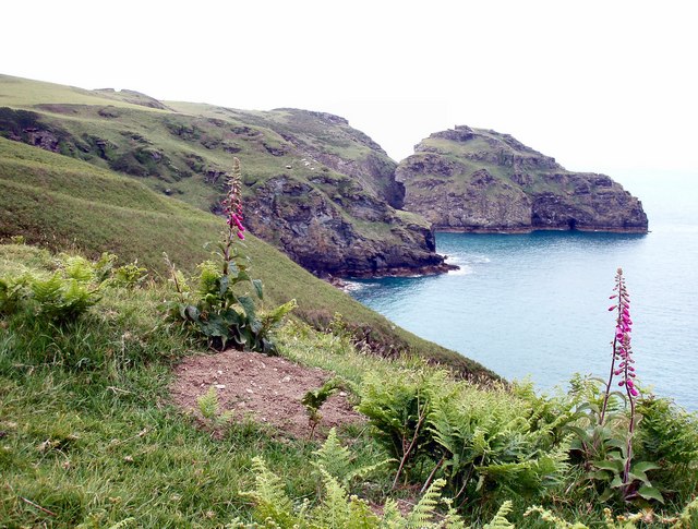
Bossiney Haven, located in the picturesque county of Cornwall, England, is a small bay renowned for its natural beauty and tranquil atmosphere. Situated near the village of Tintagel, it offers visitors a serene escape from the bustling city life. The bay is nestled between towering cliffs, providing a spectacular backdrop for sunbathers and nature enthusiasts.

Bossiney Haven is characterized by its pristine sandy beach, which stretches for approximately 200 meters at low tide, revealing fascinating rock pools teeming with marine life. The beach is sheltered by the cliffs, making it an ideal spot for families and sun-seekers to relax and enjoy the gentle waves. The bay's crystal-clear waters are also popular amongst swimmers and water sports enthusiasts.

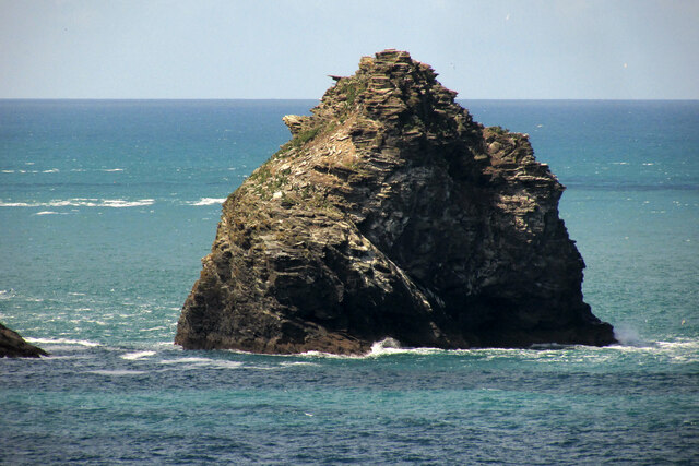
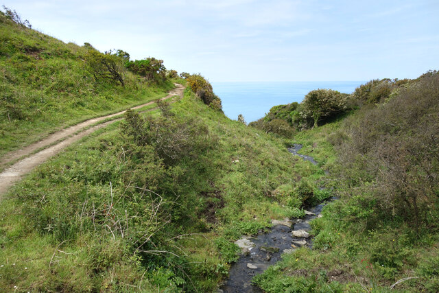
Surrounded by lush greenery and breathtaking coastal landscapes, Bossiney Haven offers ample opportunities for leisurely walks and exploration. The South West Coast Path, which runs through the area, allows visitors to take in the stunning vistas while enjoying a refreshing hike. The bay is also in close proximity to the historic Tintagel Castle, a legendary site associated with the tales of King Arthur and his knights.

Although Bossiney Haven lacks the commercialization of larger tourist destinations, it offers basic facilities such as parking and public toilets. However, visitors should be aware that there are no lifeguards on duty, so precautionary measures should be taken while enjoying the water.

In summary, Bossiney Haven is a hidden gem on Cornwall's coastline, providing visitors with a peaceful and idyllic beach experience. Its unspoiled natural beauty and proximity to historical landmarks make it a must-visit destination for those seeking tranquility and a connection to Cornwall's rich heritage.

If you have any feedback on the listing, please let us know in the comments section below.

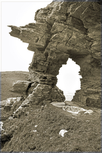
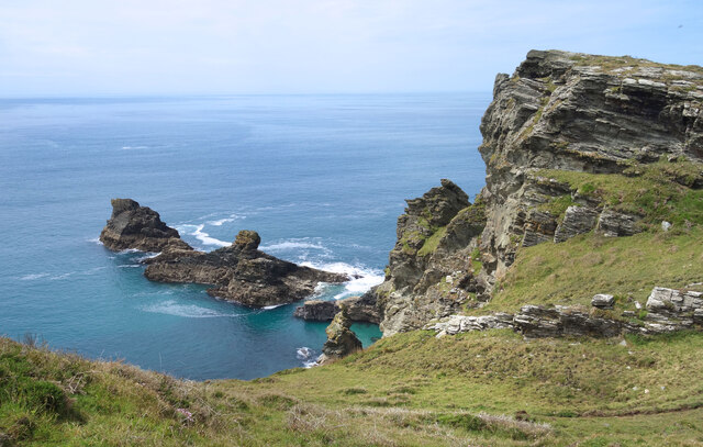
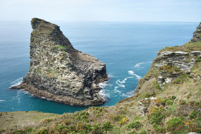
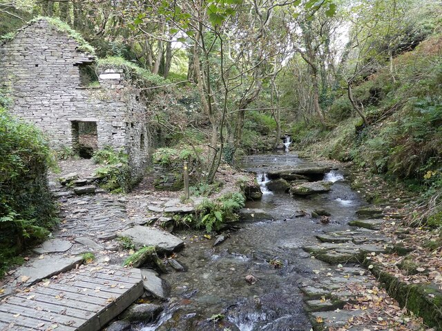
Bossiney Haven Images

Images are sourced within 2km of 50.672013/-4.7379487 or Grid Reference SX0689. Thanks to Geograph Open Source API. All images are credited.

Long Island View from coastal path at Rocky Valley Trethevey
Long Island
View from coastal path at Rocky Valley Trethevey
Ladies window On the coast north of Trevalga
Ladies window
On the coast north of Trevalga
Firebeacon Hill Headland between two islets near Trevalga
Firebeacon Hill
Headland between two islets near Trevalga
Rocky Coast near Travalga View from Ladies Window
Rocky Coast near Travalga
View from Ladies Window
Old Wayside Cross - moved to Trevalga churchyard Trevalga Cross, old head and shaft, Langdon NC No. 98 by the off-road path, in parish of Trevalga (North Cornwall District), in churchyard, South of church.

Scheduled Monument.
List Entry Number: 1014214 <span class="nowrap"><a title="https://historicengland.org.uk/listing/the-list/list-entry/1014214" rel="nofollow ugc noopener" href="https://historicengland.org.uk/listing/the-list/list-entry/1014214">Link</a><img style="margin-left:2px;" alt="External link" title="External link - shift click to open in new window" src="https://s1.geograph.org.uk/img/external.png" width="10" height="10"/></span>

To be surveyed

Milestone Society National ID: CWNC_TVA
Old Wayside Cross - moved to Trevalga churchyard
Trevalga Cross, old head and shaft, Langdon NC No. 98 by the off-road path, in parish of Trevalga (North Cornwall District), in churchyard, South of church. Scheduled Monument. List Entry Number: 1014214 LinkExternal link To be surveyed Milestone Society National ID: CWNC_TVA
View from Penally Point A detail of <a href="https://www.geograph.org.uk/photo/1466297">SX0991 : Boscastle: Willapark with Short Island beyond</a>, with Willapark on the left and Short Island off the unnamed headland with two chasms, the narrower right-hand one of which is Foot Cove. The headland is of Tredorn Slate (Devonian), while this side of the nearer headland is composed of the Boscastle Formation (Carboniferous).
View from Penally Point
A detail of SX0991 : Boscastle: Willapark with Short Island beyond, with Willapark on the left and Short Island off the unnamed headland with two chasms, the narrower right-hand one of which is Foot Cove. The headland is of Tredorn Slate (Devonian), while this side of the nearer headland is composed of the Boscastle Formation (Carboniferous).
Short Island A close view of the stack shown in <a href="https://www.geograph.org.uk/photo/6846959">SX0790 : View from Penally Point</a>.
Short Island
A close view of the stack shown in SX0790 : View from Penally Point.
Coast Path by a Stream The South West Coast Path crosses one of the many streams and rivers along its way. This is a small one, but some of the valleys are the scene of some strenuous
climbing.
Coast Path by a Stream
The South West Coast Path crosses one of the many streams and rivers along its way. This is a small one, but some of the valleys are the scene of some strenuous climbing.
Beneath Ladies Window The spectacular rock arch called Ladies Window is right on the cliff edge. <a href="https://www.geograph.org.uk/photo/3890808">SX0790 : Ladies' Window rock formation on coastal path between Boscastle & Tintagel</a> 
It is easily accessible by a well trodden path which ends exactly here. One step more would not be wise.
Beneath Ladies Window
The spectacular rock arch called Ladies Window is right on the cliff edge. SX0790 : Ladies' Window rock formation on coastal path between Boscastle & Tintagel It is easily accessible by a well trodden path which ends exactly here. One step more would not be wise.
Ladies Window Another monochrome image to go with <a href="https://www.geograph.org.uk/photo/5562689">SX0790 : Ladies window</a>
Ladies Window
Another monochrome image to go with SX0790 : Ladies window
Saddle Rocks Skerries below Trevalga Cliff.
Saddle Rocks
Skerries below Trevalga Cliff.
Long Island The largest of the rocks and islands at Trevalga.
Long Island
The largest of the rocks and islands at Trevalga.
Tintagel Castle The spectacular position of the castle, one of the most iconic locations in Cornwall, can be gauged in this view from Tintagel Island. The site is believed to have been a residence of the early rulers of Cornwall and it was named by Geoffrey of Monmouth in the 12th century as the place where King Arthur was conceived. The castle was built in the 13th century by Richard, Earl of Cornwall, possibly inspired by the Arthurian legend.
Tintagel Castle
The spectacular position of the castle, one of the most iconic locations in Cornwall, can be gauged in this view from Tintagel Island. The site is believed to have been a residence of the early rulers of Cornwall and it was named by Geoffrey of Monmouth in the 12th century as the place where King Arthur was conceived. The castle was built in the 13th century by Richard, Earl of Cornwall, possibly inspired by the Arthurian legend.
Tintagel - Castle - View through rock 'window' Whether this aperture in the eastern wall of the ruins of Tintagel Castle was a window or an arrow-loop I don't know, but it allows a view through to the cliffs on the other side.
Tintagel - Castle - View through rock 'window'
Whether this aperture in the eastern wall of the ruins of Tintagel Castle was a window or an arrow-loop I don't know, but it allows a view through to the cliffs on the other side.
Tintagel - Castle - New bridge This new bridge across to the castle at Tintagel was installed in 2019 and makes accessing the ancient ruin far less tricky than it used to be (which involved lengthy perilous rocky steps).
See <span class="nowrap"><a title="https://www.english-heritage.org.uk/visit/places/tintagel-castle/tintagel-bridge" rel="nofollow ugc noopener" href="https://www.english-heritage.org.uk/visit/places/tintagel-castle/tintagel-bridge">Link</a><img style="margin-left:2px;" alt="External link" title="External link - shift click to open in new window" src="https://s1.geograph.org.uk/img/external.png" width="10" height="10"/></span> for more information.
Tintagel - Castle - New bridge
This new bridge across to the castle at Tintagel was installed in 2019 and makes accessing the ancient ruin far less tricky than it used to be (which involved lengthy perilous rocky steps). See LinkExternal link for more information.
Tintagel - Castle - King Arthur statue I presume that this statue atop the west coastal cliffs of Tintagel Island is of King Arthur, though I suppose it may be Uther Pendragon.
Tintagel - Castle - King Arthur statue
I presume that this statue atop the west coastal cliffs of Tintagel Island is of King Arthur, though I suppose it may be Uther Pendragon.
Trewethern Mill, Rocky Valley Looking up the woodland section of Rocky Valley with the ruins of Trewethern Mill on the left. Behind this mill are some ancient Celtic rock carvings.
Trewethern Mill, Rocky Valley
Looking up the woodland section of Rocky Valley with the ruins of Trewethern Mill on the left. Behind this mill are some ancient Celtic rock carvings.
Tintagel Haven View of Tintagel Haven towards the eastern edge of Tintagel Island (left) with the very western edge of Barras Nose (right).
Tintagel Haven
View of Tintagel Haven towards the eastern edge of Tintagel Island (left) with the very western edge of Barras Nose (right).
Show me another place!

Bossiney Haven is located at Grid Ref: SX0689 (Lat: 50.672013, Lng: -4.7379487)

Unitary Authority: Cornwall

Police Authority: Devon and Cornwall

What 3 Words

///raves.boils.slant. Near Tintagel, Cornwall

Related Wikis

Bossiney Haven

Bossiney Haven (Cornish: Porth Boskyny, meaning cove at Bossiney) is a small cove in the civil parish of Tintagel. It is on the north coast of Cornwall...

Lye Cove

Lye Cove is a small coastal inlet near Tintagel on the north coast of Cornwall, South West England. The cove lies immediately below the Iron Age hill fort...

Rocky Valley

Rocky Valley (Cornish: Glynn Duwy, meaning deep valley of the river Duwy) is a small valley in the parish of Tintagel, north Cornwall, England, United...
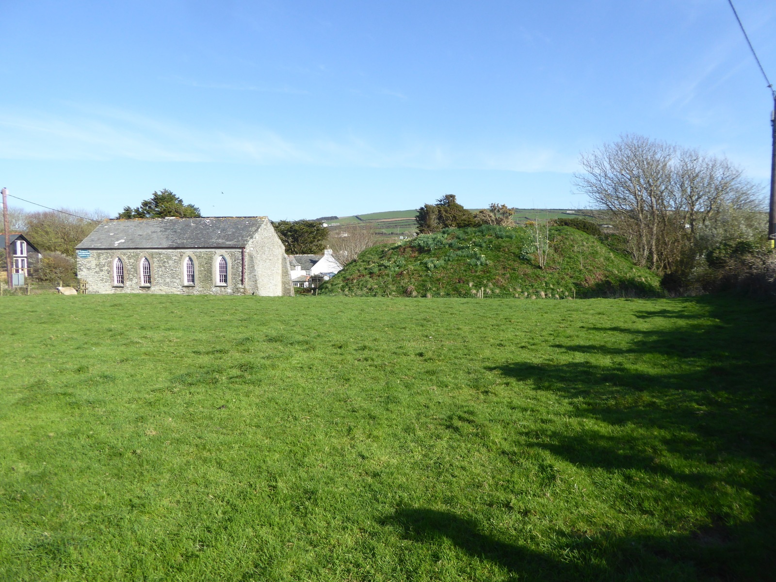
Bossiney Castle

Bossiney Castle is a Norman fortification, built in the 11th-century, following the Norman invasion of England in 1066. It is in the village of Bossiney...

Nearby Amenities

Located within 500m of 50.672013,-4.7379487
Source: PGS
Lat/Long: 50.6738985/-4.7316679
Source: PGS
Lat/Long: 50.6734339/-4.7318028
Source: PGS
Lat/Long: 50.6730432/-4.7323084
Source: PGS
Lat/Long: 50.673556/-4.7325547
Source: PGS
Lat/Long: 50.673678/-4.7329627
Source: PGS
Lat/Long: 50.672913/-4.7327327
Source: PGS
Lat/Long: 50.672771/-4.7330242
Source: PGS
Lat/Long: 50.6725622/-4.7332394
Source: PGS
Lat/Long: 50.6726084/-4.733514
Source: PGS
Lat/Long: 50.6718153/-4.7348594
Source: PGS
Lat/Long: 50.6719843/-4.7352226
Source: PGS
Lat/Long: 50.6723674/-4.7355697
Source: PGS
Lat/Long: 50.6723446/-4.7379016
Source: PGS
Lat/Long: 50.672466/-4.7381376
Source: PGS
Lat/Long: 50.672573/-4.7383677
Source: PGS
Lat/Long: 50.672829/-4.7383767
Source: PGS
Lat/Long: 50.673335/-4.7387987
Source: PGS
Lat/Long: 50.674101/-4.7390287
Source: PGS
Lat/Long: 50.6744463/-4.7395307
Source: PGS
Lat/Long: 50.673948/-4.7406367
Source: PGS
Lat/Long: 50.674198/-4.7410487
Source: PGS
Lat/Long: 50.674321/-4.7414567
Source: PGS
Lat/Long: 50.67458/-4.7412657
Source: PGS
Lat/Long: 50.674711/-4.7410677
Source: PGS
Lat/Long: 50.674851/-4.7402667
Source: PGS
Lat/Long: 50.675617/-4.7404967
Source: PGS
Lat/Long: 50.67587/-4.7407077
Source: PGS
Lat/Long: 50.675882/-4.7399007
Source: PGS
Lat/Long: 50.676135/-4.7401127
Source: PGS
Lat/Long: 50.67351/-4.7442507
Source: PGS
Lat/Long: 50.6728828/-4.7442954
Source: PGS
Lat/Long: 50.6727098/-4.7445974
Bench
Backrest: no
Lat/Long: 50.6723661/-4.741866
Bench
Backrest: no
Lat/Long: 50.6710008/-4.7348844
Bench
Lat/Long: 50.668594/-4.7364791
Bench
Backrest: yes
Lat/Long: 50.6680185/-4.7365374
Barrier: kissing_gate
Lat/Long: 50.6705154/-4.7380906
Barrier: kissing_gate
Lat/Long: 50.6682458/-4.7365752
Barrier: stile
Stile: squeezer
Lat/Long: 50.6717641/-4.7396039
Parking
Bossiney Cove Parking
Access: permissive
Charge: 1
Fee: 1 GBP honesty box
Note: Not open all year.
Parking: surface
Payment Cash: yes
Surface: grass
Lat/Long: 50.6682766/-4.7363972
Noexit: yes
Lat/Long: 50.6692592/-4.7425826
Power: pole
Lat/Long: 50.6693807/-4.733883
Telephone
Booth: K6
Covered: booth
Survey Date: 2021-12-30
Lat/Long: 50.6680014/-4.7362903
Waste Basket
Survey Date: 2021-12-30
Waste: dog_excrement
Lat/Long: 50.6680629/-4.7363488
Waste Basket
Survey Date: 2021-12-30
Lat/Long: 50.6679743/-4.7365364
Bench
Backrest: yes
Survey Date: 2021-12-30
Lat/Long: 50.6680327/-4.7363226
Bench
Backrest: yes
Survey Date: 2021-12-30
Lat/Long: 50.668421/-4.7343397
Man Made: mast
Tower Type: communication
Lat/Long: 50.6683/-4.7367116
Life Ring
Emergency: life_ring
Survey Date: 2022-01-23
Lat/Long: 50.6716046/-4.7348577
Barrier: yes
Lat/Long: 50.670571/-4.7379922
The data included in this document is from www.openstreetmap.org. The data is made available under ODbL.

Have you been to Bossiney Haven?

Leave your review of Bossiney Haven below (or comments, questions and feedback).