Camp Bay South

Bay in Wigtownshire

Scotland

Camp Bay South

Sea Cave, North end of Cairgarroch Bay
Sea Cave, North end of Cairgarroch Bay Credit: Tony Page

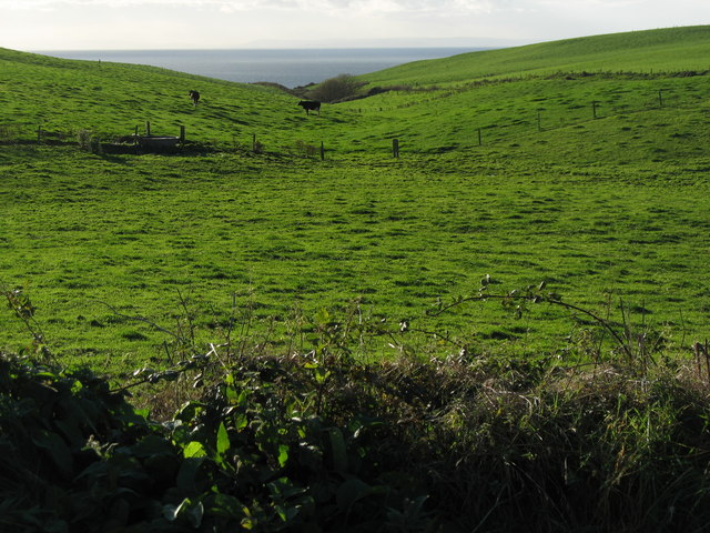
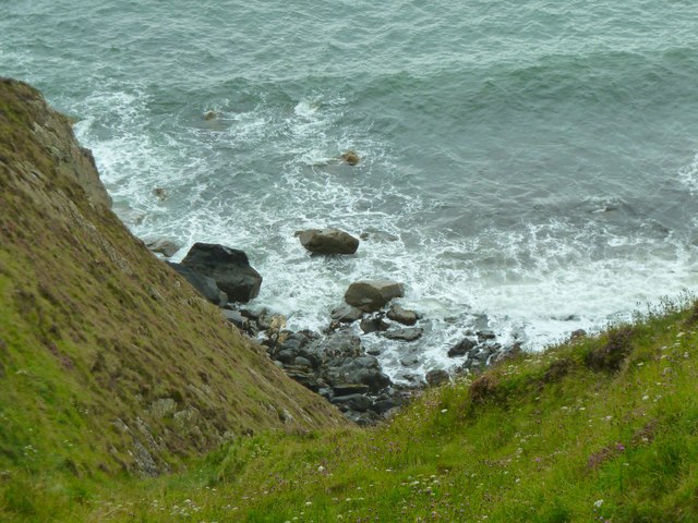
Camp Bay South, located in Wigtownshire, Scotland, is a picturesque coastal area renowned for its natural beauty and serene atmosphere. Situated on the Southern Machars, this idyllic bay offers stunning views of the Irish Sea and is surrounded by rolling hills and lush greenery.

The bay itself is characterized by its sandy beach, which stretches along the coastline for approximately one kilometer. The beach is popular among locals and tourists alike, providing ample space for relaxation, picnicking, and various water activities such as swimming, kayaking, and fishing. The clear waters of the bay also make it a favored spot for scuba diving enthusiasts.

Camp Bay South is nestled within an Area of Outstanding Natural Beauty, with its diverse flora and fauna attracting nature enthusiasts and birdwatchers. The surrounding cliffs and dunes provide excellent vantage points for observing wildlife, including seabirds, seals, and occasionally dolphins.

For those seeking a peaceful retreat, the bay offers several walking trails, allowing visitors to explore the scenic surroundings. The nearby Camp Bay Forest provides a tranquil setting for leisurely walks, while the Wigtown Bay Local Nature Reserve, a short distance away, offers a chance to discover a plethora of bird species and rare plants.

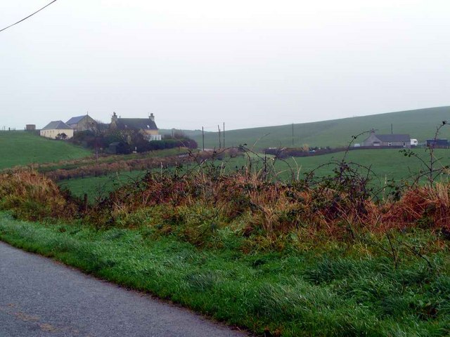
Despite its tranquil setting, Camp Bay South is conveniently located within close proximity to amenities. The nearby town of Wigtown provides several accommodation options, including cozy bed and breakfasts and self-catering cottages. Visitors can also find a selection of charming cafes, restaurants, and shops in the town, offering local produce and crafts.

In summary, Camp Bay South in Wigtownshire is a stunning coastal area that offers a perfect blend of natural beauty, recreational opportunities, and tranquility. Whether seeking adventure or relaxation, visitors to this hidden gem will surely be captivated by its charm.

If you have any feedback on the listing, please let us know in the comments section below.

Camp Bay South Images

Images are sourced within 2km of 54.811031/-5.0608084 or Grid Reference NX0350. Thanks to Geograph Open Source API. All images are credited.

Sea Cave, North end of Cairgarroch Bay
Spittal House Farm South east of the Port of Spittal Burn that flows into Port of Spittal Bay.
The Caledonian Cheese Company is based in Stranraer.
Spittal House Farm
South east of the Port of Spittal Burn that flows into Port of Spittal Bay. The Caledonian Cheese Company is based in Stranraer.
Portayew bay
Portayew bay
Portayew Burn The Antrim Mountains (approxiamtely 60km) can be seen on the horizon.
Portayew Burn
The Antrim Mountains (approxiamtely 60km) can be seen on the horizon.
Port of Spittal cliffs
Housing near Cairngarroch
Houses at Kirklauchline
Meoul Croft roadend
Meoul Croft roadend
Misty day in The Rhins Note:  also spelt 'Rhinns' but OS currently prefer one 'n'.
Misty day in The Rhins
Note: also spelt 'Rhinns' but OS currently prefer one 'n'.
Poor weather, Cairngarroch Rain and low cloud over the Rhins of Galloway. Not so bad here, but blowing a gale on the Mull.
Poor weather, Cairngarroch
Rain and low cloud over the Rhins of Galloway. Not so bad here, but blowing a gale on the Mull.
Minor road approaching Cairngarroch Croft Looking south-eastward.
Minor road approaching Cairngarroch Croft
Looking south-eastward.
Remains of mill dam The wall appears to be from the mill dam shown on the 1st edition OS map for Wigtownshire (sheet 21) surveyed in 1847-8. This dam supplied a head of water, fed by the Port of Spittal Burn for the Port of Spittal Mill (a carding mill) just downstream. There is no longer any sign of the mill itself. This, together with Port of Spittal Mill Croft, were demolished around 1869 when Knockinaam Lodge <a title="https://www.geograph.org.uk/photo/6337989" href="https://www.geograph.org.uk/photo/6337989">Link</a> was built close to the site of the croft.
Remains of mill dam
The wall appears to be from the mill dam shown on the 1st edition OS map for Wigtownshire (sheet 21) surveyed in 1847-8. This dam supplied a head of water, fed by the Port of Spittal Burn for the Port of Spittal Mill (a carding mill) just downstream. There is no longer any sign of the mill itself. This, together with Port of Spittal Mill Croft, were demolished around 1869 when Knockinaam Lodge Link was built close to the site of the croft.
Port of Spittal Burn The burn is here following the old mill lade from the mill dam (which was behind the photographer) for Port of Spittal Mill (a carding mill) just downstream. There is no longer any sign of the mill itself.
Port of Spittal Burn
The burn is here following the old mill lade from the mill dam (which was behind the photographer) for Port of Spittal Mill (a carding mill) just downstream. There is no longer any sign of the mill itself.
Rocky shore Low cliffs just south of Port of Spittal Bay.
Rocky shore
Low cliffs just south of Port of Spittal Bay.
Small caves on the beach Just south of Port of Spittal Bay.
Small caves on the beach
Just south of Port of Spittal Bay.
Finlock Bay View from the cliff top down to the rocks and bay. This was as close as it felt comfortable to be in order to bag this first without a) electrocuting myself on the nearby fencing or b) slipping away down the sheer cliff face. That said it was a great view across the North Channel with the next stop Belfast.
Finlock Bay
View from the cliff top down to the rocks and bay. This was as close as it felt comfortable to be in order to bag this first without a) electrocuting myself on the nearby fencing or b) slipping away down the sheer cliff face. That said it was a great view across the North Channel with the next stop Belfast.
Rocks at Finlock Closer view from the cliff top to the rocks that surround Finlock Bay.
Rocks at Finlock
Closer view from the cliff top to the rocks that surround Finlock Bay.
Knockienausk Head View from the cliff top straight down a gully to the rocks below and this was as close as I wanted to get!
Knockienausk Head
View from the cliff top straight down a gully to the rocks below and this was as close as I wanted to get!
Show me another place!

Camp Bay South is located at Grid Ref: NX0350 (Lat: 54.811031, Lng: -5.0608084)

Unitary Authority: Dumfries and Galloway

Police Authority: Dumfries and Galloway

What 3 Words

///deduct.endlessly.slurping. Near Stranraer, Dumfries & Galloway

Related Wikis

Knockinaam Lodge

Knockinaam Lodge is a hotel and restaurant located about 3.5 miles South of Portpatrick, Dumfries & Galloway, Scotland. As of 2008, the restaurant holds...

Dunskey Castle

Dunskey Castle is a ruined, 12th-century tower house or castle, located 0.5 miles (0.80 km) south of the village of Portpatrick, Rhinns, Wigtownshire,...

Colfin railway station

Colfin railway station, located in Wigtownshire, Scotland, between Portpatrick and Stranraer, was a station on the Portpatrick and Wigtownshire Joint Railway...

Dunskey

Dunskey Estate (also known as Portree Estate) is north of Portpatrick on the west coast of Scotland. The B-listed mansion dates from the start of the twentieth...

Portpatrick railway station

Portpatrick railway station was a railway station serving the village of Portpatrick, Dumfries & Galloway, Scotland. Opened in 1862 the station served...

Rhins of Galloway

The Rhins of Galloway, otherwise known as the Rhins of Wigtownshire (or as The Rhins, also spelled The Rhinns; Scottish Gaelic: Na Rannaibh), is a hammer...

Portpatrick

Portpatrick is a village and civil parish in the historical county of Wigtownshire, Dumfries and Galloway, Scotland. It is located on the west coast of...

Stoneykirk

Stoneykirk (Scottish Gaelic: Eaglais Steafain) is an area and a village in the heart of the Rhins of Galloway, Wigtownshire, in the administrative council...

Nearby Amenities

Located within 500m of 54.811031,-5.0608084
Created By: dmgroom_coastlines
Source: PGS
Lat/Long: 54.812904/-5.066438
Created By: dmgroom_coastlines
Source: PGS
Lat/Long: 54.812396/-5.066191
Created By: dmgroom_coastlines
Source: PGS
Lat/Long: 54.811635/-5.065708
Created By: dmgroom_coastlines
Source: PGS
Lat/Long: 54.811511/-5.065479
Created By: dmgroom_coastlines
Source: PGS
Lat/Long: 54.811387/-5.065252
Created By: dmgroom_coastlines
Source: PGS
Lat/Long: 54.811262/-5.065023
Created By: dmgroom_coastlines
Source: PGS
Lat/Long: 54.811285/-5.063693
Created By: dmgroom_coastlines
Source: PGS
Lat/Long: 54.811292/-5.06325
Created By: dmgroom_coastlines
Source: PGS
Lat/Long: 54.811082/-5.060578
Created By: dmgroom_coastlines
Source: PGS
Lat/Long: 54.810958/-5.060351
Created By: dmgroom_coastlines
Source: PGS
Lat/Long: 54.810833/-5.060122
Created By: dmgroom_coastlines
Source: PGS
Lat/Long: 54.81071/-5.059895
Created By: dmgroom_coastlines
Source: PGS
Lat/Long: 54.810201/-5.059646
Created By: dmgroom_coastlines
Source: PGS
Lat/Long: 54.810095/-5.05831
Created By: dmgroom_coastlines
Source: PGS
Lat/Long: 54.810103/-5.057867
Created By: dmgroom_coastlines
Source: PGS
Lat/Long: 54.810111/-5.057424
Created By: dmgroom_coastlines
Source: PGS
Lat/Long: 54.809877/-5.056082
Created By: dmgroom_coastlines
Source: PGS
Lat/Long: 54.809753/-5.055855
Created By: dmgroom_coastlines
Source: PGS
Lat/Long: 54.809629/-5.055626
Created By: dmgroom_coastlines
Source: PGS
Lat/Long: 54.809505/-5.055398
Created By: dmgroom_coastlines
Source: PGS
Lat/Long: 54.80938/-5.055169
Created By: dmgroom_coastlines
Source: PGS
Lat/Long: 54.809388/-5.054726
Created By: dmgroom_coastlines
Source: PGS
Lat/Long: 54.809403/-5.05384
The data included in this document is from www.openstreetmap.org. The data is made available under ODbL.

Have you been to Camp Bay South?

Leave your review of Camp Bay South below (or comments, questions and feedback).