Barafundle Bay

Bay in Pembrokeshire

Wales

Barafundle Bay

Cliffs west of Greenala Point View from a kayak showing 50m high cliffs in Old Red Sandstone. Cliff collapse usually occurs along vertical fractures (joints). Susceptibility of the joints and softer beds (mudstones) to weathering is also evident.

The influence of salt spray from breaking waves is indicated by the very high position of the orange lichen zone on this cliff face. 

Note that this photo was taken on a very calm day and only experienced kayakers should venture along this rugged coastline. Weather can change quickly and wind, waves and tidal currents often create dangerous conditions.

These cliffs are within a Site of Special Scientific Interest (SSSI). Please see the website of Pembrokeshire Outdoor Charter Group <span class="nowrap"><a title="http://www.pembrokeshireoutdoors.org.uk" rel="nofollow ugc noopener" href="http://www.pembrokeshireoutdoors.org.uk">Link</a><img style="margin-left:2px;" alt="External link" title="External link - shift click to open in new window" src="https://s1.geograph.org.uk/img/external.png" width="10" height="10"/></span> for guidance on avoiding disturbance to wildlife (nesting birds, seals etc) and for a list of local providers of outdoor activities.

In the foreground a visitor from Ohio (USA) is enjoying his first time on a kayak (well done Perry!).
Cliffs west of Greenala Point Credit: Sid Howells

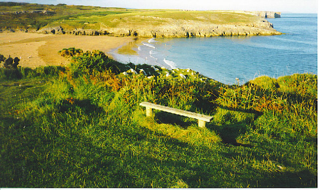
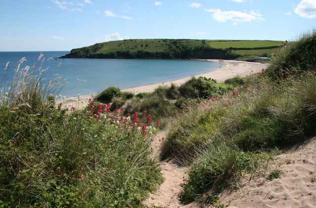
Barafundle Bay is a stunning and secluded beach located on the south coast of Pembrokeshire, Wales. Situated within the Pembrokeshire Coast National Park, this bay is considered one of the most beautiful and unspoiled beaches in the country.

The bay is renowned for its golden sands, crystal-clear turquoise waters, and picturesque surroundings. It is surrounded by dramatic cliffs and lush greenery, creating a truly breathtaking and serene environment. This natural beauty has earned Barafundle Bay numerous accolades, including being named one of the top 12 beaches in the world by the lifestyle magazine, Passport.

Access to Barafundle Bay is limited, adding to its charm and exclusivity. Visitors must park their vehicles in a nearby car park and then embark on a scenic half-mile walk through a wooded area and over sand dunes to reach the beach. This secluded nature ensures a peaceful and tranquil experience for those lucky enough to visit.

Due to its remote location, there are no facilities or amenities available at Barafundle Bay. Visitors are advised to bring their own food, water, and other essentials. The absence of commercial developments and crowds adds to the bay's untouched and natural appeal.

Barafundle Bay is a popular destination for nature lovers, photographers, and those seeking a quiet and idyllic beach experience. It is a prime spot for swimming, sunbathing, and picnicking in a pristine and unspoiled setting.

If you have any feedback on the listing, please let us know in the comments section below.

Barafundle Bay Images

Images are sourced within 2km of 51.618087/-4.8999575 or Grid Reference SR9995. Thanks to Geograph Open Source API. All images are credited.

Cliffs west of Greenala Point View from a kayak showing 50m high cliffs in Old Red Sandstone. Cliff collapse usually occurs along vertical fractures (joints). Susceptibility of the joints and softer beds (mudstones) to weathering is also evident.

The influence of salt spray from breaking waves is indicated by the very high position of the orange lichen zone on this cliff face. 

Note that this photo was taken on a very calm day and only experienced kayakers should venture along this rugged coastline. Weather can change quickly and wind, waves and tidal currents often create dangerous conditions.

These cliffs are within a Site of Special Scientific Interest (SSSI). Please see the website of Pembrokeshire Outdoor Charter Group <span class="nowrap"><a title="http://www.pembrokeshireoutdoors.org.uk" rel="nofollow ugc noopener" href="http://www.pembrokeshireoutdoors.org.uk">Link</a><img style="margin-left:2px;" alt="External link" title="External link - shift click to open in new window" src="https://s1.geograph.org.uk/img/external.png" width="10" height="10"/></span> for guidance on avoiding disturbance to wildlife (nesting birds, seals etc) and for a list of local providers of outdoor activities.

In the foreground a visitor from Ohio (USA) is enjoying his first time on a kayak (well done Perry!).
Cliffs west of Greenala Point
View from a kayak showing 50m high cliffs in Old Red Sandstone. Cliff collapse usually occurs along vertical fractures (joints). Susceptibility of the joints and softer beds (mudstones) to weathering is also evident. The influence of salt spray from breaking waves is indicated by the very high position of the orange lichen zone on this cliff face. Note that this photo was taken on a very calm day and only experienced kayakers should venture along this rugged coastline. Weather can change quickly and wind, waves and tidal currents often create dangerous conditions. These cliffs are within a Site of Special Scientific Interest (SSSI). Please see the website of Pembrokeshire Outdoor Charter Group LinkExternal link for guidance on avoiding disturbance to wildlife (nesting birds, seals etc) and for a list of local providers of outdoor activities. In the foreground a visitor from Ohio (USA) is enjoying his first time on a kayak (well done Perry!).
Anticline in cliffs west of Greenala Point Plunging anticline in cliffs of Old Red Sandstone. 

Slope-over-wall cliff profile is evident and landslide debris mantles the coastal slope. Large angular blocks on foreshore are landslide/rockfall debris that is still too large to have been removed by wave action (not yet worn down by abrasive action of sand).

Person at boundary of beach sand/blocks (lower left) shows scale.

NB. do not attempt to reach this beach by scrambling down the cliffs - there are deep fissures amongst the blackthorns/brambles on the upper slope and the lower cliff is very unstable. 

Please see guidance for kayakers in the description under my photo of cliffs near Greenala Point <a title="https://www.geograph.org.uk/photo/1567250" href="https://www.geograph.org.uk/photo/1567250">Link</a> .
Anticline in cliffs west of Greenala Point
Plunging anticline in cliffs of Old Red Sandstone. Slope-over-wall cliff profile is evident and landslide debris mantles the coastal slope. Large angular blocks on foreshore are landslide/rockfall debris that is still too large to have been removed by wave action (not yet worn down by abrasive action of sand). Person at boundary of beach sand/blocks (lower left) shows scale. NB. do not attempt to reach this beach by scrambling down the cliffs - there are deep fissures amongst the blackthorns/brambles on the upper slope and the lower cliff is very unstable. Please see guidance for kayakers in the description under my photo of cliffs near Greenala Point Link .
Greenala Point This view north from cliffs south of Stackpole Quay (SR 993 956) shows the coastline extending c. 1km west of Greenala Point (near right hand edge of photo).

These cliffs are part of a Site of Special Scientific Interest (SSSI) extending from Stackpole Quay to Freshwater East.

The cliffs and coastal slopes have been purchased by the National Trust as part of their 'Project Neptune' conservation programme. 

The Pembrokeshire coastline was designated as a National Park in 1952, and the coast path is a National Trail. This national park is the only one in the UK that is predominantly coastal.

The ?Iron Age promontory fort at Greenala Point is a Scheduled Ancient Monument (SAM)

Some detail on the geology is provided in my other Geograph photos of this coastline.
Greenala Point
This view north from cliffs south of Stackpole Quay (SR 993 956) shows the coastline extending c. 1km west of Greenala Point (near right hand edge of photo). These cliffs are part of a Site of Special Scientific Interest (SSSI) extending from Stackpole Quay to Freshwater East. The cliffs and coastal slopes have been purchased by the National Trust as part of their 'Project Neptune' conservation programme. The Pembrokeshire coastline was designated as a National Park in 1952, and the coast path is a National Trail. This national park is the only one in the UK that is predominantly coastal. The ?Iron Age promontory fort at Greenala Point is a Scheduled Ancient Monument (SAM) Some detail on the geology is provided in my other Geograph photos of this coastline.
Stackpole Quay Stackpole Quay is on the boundary between the Old Red Sandstone cliffs and grey Carboniferous Limestone. The limestone layers have been tilted into a vertical position. Today the harbour is used by local boatmen
Stackpole Quay
Stackpole Quay is on the boundary between the Old Red Sandstone cliffs and grey Carboniferous Limestone. The limestone layers have been tilted into a vertical position. Today the harbour is used by local boatmen
Barafundle Bay Barafundle Beach is a secluded place on the Stackpole Estate accessible by a footpath over the cliffs from Stackpole Quay.
Barafundle Bay
Barafundle Beach is a secluded place on the Stackpole Estate accessible by a footpath over the cliffs from Stackpole Quay.
The bridge at Stackpole Centre The eight arch bridge heading back through Stackpole Park
The bridge at Stackpole Centre
The eight arch bridge heading back through Stackpole Park
Near the Raming Hole to the west of Stackpole Head On the glorious Pembrokeshire Coastal Path
Near the Raming Hole to the west of Stackpole Head
On the glorious Pembrokeshire Coastal Path
Broad Haven, Pembrokeshire Rough seas at Broad Haven, the blocked entrance to Bosherston Lily Ponds
Broad Haven, Pembrokeshire
Rough seas at Broad Haven, the blocked entrance to Bosherston Lily Ponds
Near Stackpole Quay Grazing land adjacent to Pembrokeshire Coastal path.
Near Stackpole Quay
Grazing land adjacent to Pembrokeshire Coastal path.
View from near Stackpole. View north east from the Pembrokeshire Coastal path near Stackpole Quay looking north east towards Freshwater East.
View from near Stackpole.
View north east from the Pembrokeshire Coastal path near Stackpole Quay looking north east towards Freshwater East.
Gift wrapped. Cylindrical bales awaiting Winter.
Gift wrapped.
Cylindrical bales awaiting Winter.
Barafundle Bay Photo of Barafundle Bay from the east. This was taken at 10:00 am emphasising the effort it takes to get to this unspoilt beach.
Barafundle Bay
Photo of Barafundle Bay from the east. This was taken at 10:00 am emphasising the effort it takes to get to this unspoilt beach.
Broad Haven beach Looking NE from the car park walk down to the beach.
Broad Haven beach
Looking NE from the car park walk down to the beach.
Stackpole Inn An excellent pub, good food, good beer, friendly. Stopped here after a couple of nearby GeoCaches.
Stackpole Inn
An excellent pub, good food, good beer, friendly. Stopped here after a couple of nearby GeoCaches.
Saddle Point and Church Rock. Taken from Broad Haven.
Saddle Point and Church Rock.
Taken from Broad Haven.
Lilies on the Bosherston Ponds. Dammed for Fishing Ponds.
Lilies on the Bosherston Ponds.
Dammed for Fishing Ponds.
The upper bridge at Bosherston Ponds.
Broad Haven. Evening on the Pembroke Coastal Path.
Broad Haven.
Evening on the Pembroke Coastal Path.
Show me another place!

Barafundle Bay is located at Grid Ref: SR9995 (Lat: 51.618087, Lng: -4.8999575)

Unitary Authority: Pembrokeshire

Police Authority: Dyfed Powys

What 3 Words

///bright.entry.rezoning. Near Bosherston, Pembrokeshire

Nearby Locations

Barafundle Bay

Related Wikis

Barafundle Bay

Barafundle Bay (Welsh: Bae Barafundle) is a remote, slightly curved, east-facing sandy beach, near Stackpole Quay in Pembrokeshire, Wales. It is part of...

Stackpole Estate

The Stackpole Estate (Welsh: Ystad Ystagbwll) is located between the villages of Stackpole (Welsh: Ystagbwll) and Bosherston (Welsh: Llanfihangel-clogwyn...

Trewent Point

Stackpole Quay - Trewent Point is a cliff on the Castlemartin Peninsula of South Pembrokeshire, South Wales and is a Site of Special Scientific Interest...
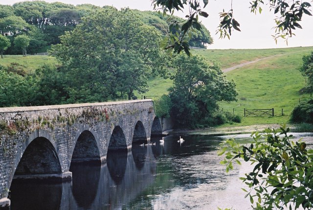
Eight-Arch Bridge

The Eight Arch Bridge on the Stackpole Estate is a grade II* listed construction, in Pembrokeshire, Wales. It is owned and maintained by the National...

Nearby Amenities

Located within 500m of 51.618087,-4.8999575
Barrier: kissing_gate
Foot: yes
Motor Vehicle: no
Lat/Long: 51.6165299/-4.9024608
Barafundle Bay
Natural: bay
Lat/Long: 51.6181129/-4.9014073
Lorts Cave
Place: locality
Lat/Long: 51.6205507/-4.8994453
Lattice Windows
Place: locality
Lat/Long: 51.6160425/-4.9001272
Griffith Lorts Hole
Place: locality
Lat/Long: 51.6165902/-4.8999009
Lorts Cave
Access: yes
Direction: 200
Ele: 0
Fee: no
Natural: cave_entrance
Lat/Long: 51.6211819/-4.89975
The data included in this document is from www.openstreetmap.org. The data is made available under ODbL.

Have you been to Barafundle Bay?

Leave your review of Barafundle Bay below (or comments, questions and feedback).