Broadsea Bay

Bay in Wigtownshire

Scotland

Broadsea Bay

Pond on the road to Larbrax Shore
Pond on the road to Larbrax Shore Credit: Oliver Dixon

Broadsea Bay is a picturesque bay located in Wigtownshire, a historic county in southwestern Scotland. Situated on the western coast of the Rhins of Galloway, it offers stunning views of the Irish Sea and the surrounding rugged coastline. The bay is known for its tranquil and secluded atmosphere, making it a popular destination for those seeking a peaceful retreat.

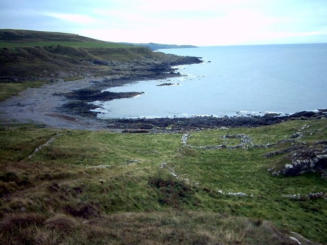
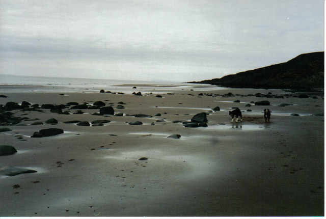
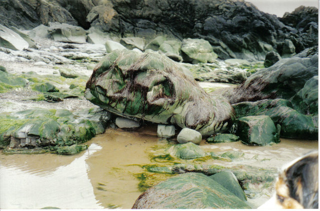
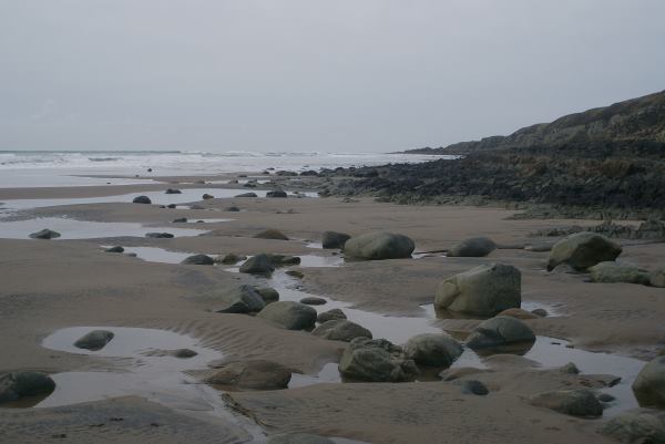
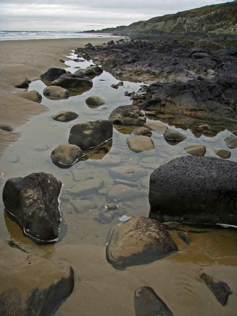
The bay is characterized by its sandy beach, which stretches for approximately 1.5 kilometers along the shoreline. The sand is fine and golden, making it ideal for leisurely walks and sunbathing during the warmer months. At low tide, the bay reveals extensive rock pools, teeming with marine life, providing an excellent opportunity for exploration and discovery.

The surrounding cliffs of Broadsea Bay are formed from sandstone and offer a dramatic backdrop to the bay. They are home to various bird species, including gulls and cormorants, which can be observed nesting and fishing in the area. The bay is also known for its diverse wildlife, with common sightings of seals and dolphins swimming offshore.

Facilities in Broadsea Bay are limited, with no shops or cafes in immediate proximity. However, a nearby car park provides easy access to the bay, and public toilets are available for visitors' convenience. The bay is also a popular spot for water sports enthusiasts, with windsurfing and kayaking being popular activities due to the bay's favorable conditions.

Overall, Broadsea Bay in Wigtownshire offers a serene and unspoiled natural environment, making it a haven for nature lovers and those seeking a peaceful coastal escape.

If you have any feedback on the listing, please let us know in the comments section below.
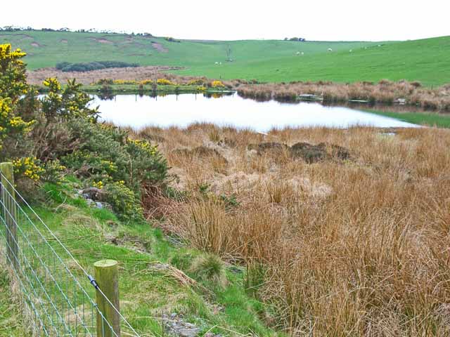
Broadsea Bay Images

Images are sourced within 2km of 54.891607/-5.165204 or Grid Reference NW9759. Thanks to Geograph Open Source API. All images are credited.

Pond on the road to Larbrax Shore
Storm damage to wood, North Rhins On the B738
Storm damage to wood, North Rhins
On the B738
Salt Pans Bay Salt made in the pans was used to cure and pack herrings landed at local ports.  Salt was an immensely valuable commodity in the 18th century.
Salt Pans Bay
Salt made in the pans was used to cure and pack herrings landed at local ports. Salt was an immensely valuable commodity in the 18th century.
Beach, Labrax Bay Low tide at the North end of Labrax Bay, nearing Cranberry Point.
Beach, Labrax Bay
Low tide at the North end of Labrax Bay, nearing Cranberry Point.
Rock, Labrax, Broadsea Bay Named by children "The Monster Rock", the seaweed covering it changes daily giving it differing expressions.
Rock, Labrax, Broadsea Bay
Named by children "The Monster Rock", the seaweed covering it changes daily giving it differing expressions.
Larbrax Bay Shore at Larbrax Bay at low tide looking north
Larbrax Bay
Shore at Larbrax Bay at low tide looking north
Larbrax Bay Killintringan Lighthouse in the far distance
Larbrax Bay
Killintringan Lighthouse in the far distance
Larbrax Bay Looking west, with Ireland just visible on the horizon.
Larbrax Bay
Looking west, with Ireland just visible on the horizon.
Larbrax Bay Looking northwest to Cranberry Point
Larbrax Bay
Looking northwest to Cranberry Point
Larbrax Bay Seen at high water with a gale blowing in from the North Channel. Killantringan lighthouse sits on the far distant headland. The bay takes its name from the nearby farm of Larbrax, which is from the Gaelic 'learg breac' meaning speckled slope.
Larbrax Bay
Seen at high water with a gale blowing in from the North Channel. Killantringan lighthouse sits on the far distant headland. The bay takes its name from the nearby farm of Larbrax, which is from the Gaelic 'learg breac' meaning speckled slope.
Sea View from Larbrax Beach Nice view from Larbrax beach
Sea View from Larbrax Beach
Nice view from Larbrax beach
Lochan on the track to Larbrax Bay This little lochan is beside the track which leads from the B738 to the shore at Larbrax Bay.
Lochan on the track to Larbrax Bay
This little lochan is beside the track which leads from the B738 to the shore at Larbrax Bay.
Larbrax Farm, North Rhinns View from B738 across snow and ice-covered fields to Larbrax Farm, then North Channel with coast of Northern Ireland in background below cloud line.
Larbrax Farm, North Rhinns
View from B738 across snow and ice-covered fields to Larbrax Farm, then North Channel with coast of Northern Ireland in background below cloud line.
The entrance to Larbrax School House
Tringan Wood on the B738
The turning to Balgracie
Larbrax Bay at low tide
Collecting driftwood, Larbrax Bay
Show me another place!

Broadsea Bay is located at Grid Ref: NW9759 (Lat: 54.891607, Lng: -5.165204)

Unitary Authority: Dumfries and Galloway

Police Authority: Dumfries and Galloway

What 3 Words

///zaps.supper.threading. Near Stranraer, Dumfries & Galloway

Related Wikis

Galdenoch Castle

Galdenoch Castle is a tower house near the Scottish village of Leswalt in the Council Area Dumfries and Galloway . The ruin is listed as a Scheduled Monument...

Killantringan Lighthouse

Killantringan Lighthouse is a lighthouse located near Portpatrick in Dumfries and Galloway, south-west Scotland. The light came into operation in 1900...

MV Craigantlet

MV Craigantlet was a German-owned, Cyprus-registered container ship operated on time-charter by Cawoods Containers Ltd of Belfast. She ran aground on 26...

Portpatrick

Portpatrick is a village and civil parish in the historical county of Wigtownshire, Dumfries and Galloway, Scotland. It is located on the west coast of...

Portpatrick railway station

Portpatrick railway station was a railway station serving the village of Portpatrick, Dumfries & Galloway, Scotland. Opened in 1862 the station served...

Leswalt

Leswalt (Scottish Gaelic: Lios Uillt) is a village and civil parish in Dumfries and Galloway, south-west Scotland. It lies between Portpatrick and Stranraer...

Dunskey

Dunskey Estate (also known as Portree Estate) is north of Portpatrick on the west coast of Scotland. The B-listed mansion dates from the start of the twentieth...

Dunskey Castle

Dunskey Castle is a ruined, 12th-century tower house or castle, located 0.5 miles (0.80 km) south of the village of Portpatrick, Rhinns, Wigtownshire,...

Nearby Amenities

Located within 500m of 54.891607,-5.165204
Created By: dmgroom_coastlines
Source: PGS
Lat/Long: 54.896102/-5.165372
Created By: dmgroom_coastlines
Source: PGS
Lat/Long: 54.895978/-5.165144
Created By: dmgroom_coastlines
Source: PGS
Lat/Long: 54.895722/-5.16513
Created By: dmgroom_coastlines
Source: PGS
Lat/Long: 54.895467/-5.165117
Created By: dmgroom_coastlines
Source: PGS
Lat/Long: 54.894962/-5.164645
Created By: dmgroom_coastlines
Source: PGS
Lat/Long: 54.894459/-5.164174
Created By: dmgroom_coastlines
Source: PGS
Lat/Long: 54.894334/-5.163944
Created By: dmgroom_coastlines
Source: PGS
Lat/Long: 54.894211/-5.163716
Source: PGS
Lat/Long: 54.8934282/-5.1626973
Source: PGS
Lat/Long: 54.8929328/-5.1624109
Source: PGS
Lat/Long: 54.8921448/-5.162207
Source: PGS
Lat/Long: 54.891683/-5.1617028
Place: farm
Lat/Long: 54.890544/-5.1585544
Power: pole
Lat/Long: 54.8932662/-5.1587408
Power: pole
Lat/Long: 54.8929543/-5.1594216
Power: pole
Lat/Long: 54.8906307/-5.1586657
Power: pole
Lat/Long: 54.8909601/-5.1582971
Power: pole
Lat/Long: 54.8912815/-5.1576187
The data included in this document is from www.openstreetmap.org. The data is made available under ODbL.

Have you been to Broadsea Bay?

Leave your review of Broadsea Bay below (or comments, questions and feedback).