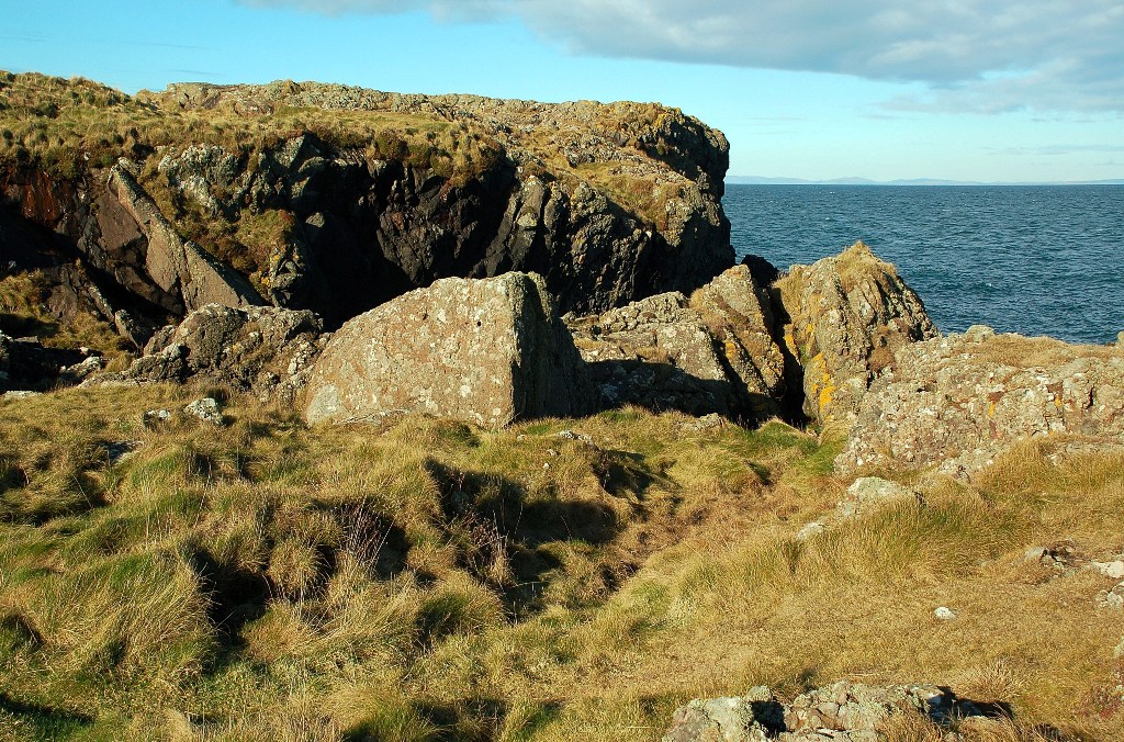
Swallow Port

Bay in Wigtownshire

Scotland

Swallow Port

Cattle feed lot near Castle Ban At the end of the road from Mains of Aries; 33 metres from the rocky west coast.
Cattle feed lot near Castle Ban Credit: M J Richardson

Swallow Port, located in Wigtownshire, is a picturesque bay nestled along the southwest coast of Scotland. This charming coastal area offers visitors breathtaking views of the Irish Sea and a tranquil atmosphere that is perfect for relaxation and exploration.

The bay is named after the large population of swallows that migrate to the area during the summer months, creating a delightful spectacle as they swoop and dive through the clear blue skies. This natural phenomenon adds to the allure of Swallow Port, attracting birdwatchers and nature enthusiasts from far and wide.

The bay itself boasts a sandy beach that stretches for several miles, providing ample space for sunbathing, picnicking, and leisurely strolls along the shore. The crystal-clear waters of the Irish Sea are ideal for swimming, sailing, and other water activities, making it a popular destination for outdoor enthusiasts.

Surrounding the bay, visitors will find rolling hills and picturesque countryside, offering opportunities for scenic walks and hikes. The area is also home to a diverse array of wildlife, including seals, dolphins, and various seabirds, adding to the natural beauty and biodiversity of Swallow Port.

In terms of amenities, Swallow Port offers a range of accommodations, including cozy bed and breakfasts, cottages, and hotels. There are also several charming cafes, restaurants, and shops in the nearby village, providing visitors with a taste of local cuisine and unique souvenirs.

Overall, Swallow Port in Wigtownshire is a hidden gem on Scotland's southwest coast, offering visitors a peaceful retreat surrounded by stunning natural beauty and abundant wildlife.

If you have any feedback on the listing, please let us know in the comments section below.

Swallow Port Images

Images are sourced within 2km of 54.955945/-5.183825 or Grid Reference NW9667. Thanks to Geograph Open Source API. All images are credited.

Cattle feed lot near Castle Ban At the end of the road from Mains of Aries; 33 metres from the rocky west coast.
Cattle feed lot near Castle Ban
At the end of the road from Mains of Aries; 33 metres from the rocky west coast.
Grassland and Gorse at Mains of Aries The rock over which the sea is breaking is the Ebbstone or Craig Laggan <a href="https://www.geograph.org.uk/photo/7418717">NW9569 : Craig Laggan or the Ebbstone</a>.
Grassland and Gorse at Mains of Aries
The rock over which the sea is breaking is the Ebbstone or Craig Laggan NW9569 : Craig Laggan or the Ebbstone.
Pillar at Mains of Airies A strange structure by the edge of the track west of the farm. It is not mentioned on Canmore, but there is a Medieval Motte nearby. In the field beyond is a smartly constructed watering place for cattle. Beyond that is Orbain Hill.
Pillar at Mains of Airies
A strange structure by the edge of the track west of the farm. It is not mentioned on Canmore, but there is a Medieval Motte nearby. In the field beyond is a smartly constructed watering place for cattle. Beyond that is Orbain Hill.
Pastures at Mains of Airies Extensive grass fields on the flanks of Lingloskin Hill, with a  brick-built watering trough serving both sides of the fence.
Pastures at Mains of Airies
Extensive grass fields on the flanks of Lingloskin Hill, with a brick-built watering trough serving both sides of the fence.
Scrub at Airies With a wave cloud over the North Channel.
Scrub at Airies
With a wave cloud over the North Channel.
The turning to Drumleight
A new build at Drumleight
Approaching Little Cairnbrock on the B738
Bends on the B738
Bends on the B738
Approaching a junction on the B738
A junction on the B738 The turning to the left is a minor road to Leswalt.
A junction on the B738
The turning to the left is a minor road to Leswalt.
A straight stretch on the B738
The turning to Mains of Cairnbrock
The turning to Cairnbrock Cottages
Cottages beside the B738 The entrance to High Auchneel is between the two white cottages on the right.
Cottages beside the B738
The entrance to High Auchneel is between the two white cottages on the right.
Looking towards Castle Ban This view is taken from the elevated garden at Dally Cottage.  Castle Ban is a circular motte described as "a green knoll projecting from the face of the heugh". [R W Feachem 1956]
Looking towards Castle Ban
This view is taken from the elevated garden at Dally Cottage. Castle Ban is a circular motte described as "a green knoll projecting from the face of the heugh". [R W Feachem 1956]
Looking towards Glen Hill The track, to the left, goes to Dally. The track, turning towards the photographer, is the entrance to Dally Cottage.
Looking towards Glen Hill
The track, to the left, goes to Dally. The track, turning towards the photographer, is the entrance to Dally Cottage.
What's this strange thing in our field? The car was parked by the side of the track that goes to the house on the shore. The view was taken from the beach.
What's this strange thing in our field?
The car was parked by the side of the track that goes to the house on the shore. The view was taken from the beach.
Show me another place!

Swallow Port is located at Grid Ref: NW9667 (Lat: 54.955945, Lng: -5.183825)

Unitary Authority: Dumfries and Galloway

Police Authority: Dumfries and Galloway

What 3 Words

///melt.fighters.cashiers. Near Cairnryan, Dumfries & Galloway

Related Wikis

Ervie

Ervie is a small village in Dumfries and Galloway, Scotland, in the Rhins of Galloway, just outside Stranraer.

Galdenoch Castle

Galdenoch Castle is a tower house near the Scottish village of Leswalt in the Council Area Dumfries and Galloway . The ruin is listed as a Scheduled Monument...

Corsewall Point

Corsewall Point, or Corsill Point, is a headland at the northern end of the Rhins of Galloway in Scotland. A lighthouse, Corsewall Lighthouse, was placed...

Leswalt

Leswalt (Scottish Gaelic: Lios Uillt) is a village and civil parish in Dumfries and Galloway, south-west Scotland. It lies between Portpatrick and Stranraer...

Nearby Amenities

Located within 500m of 54.955945,-5.183825
Created By: dmgroom_coastlines
Source: PGS
Lat/Long: 54.960243/-5.181511
Created By: dmgroom_coastlines
Source: PGS
Lat/Long: 54.959987/-5.181497
Created By: dmgroom_coastlines
Source: PGS
Lat/Long: 54.959219/-5.181455
Created By: dmgroom_coastlines
Source: PGS
Lat/Long: 54.958959/-5.181663
Created By: dmgroom_coastlines
Source: PGS
Lat/Long: 54.958943/-5.182552
Created By: dmgroom_coastlines
Source: PGS
Lat/Long: 54.958427/-5.182748
Created By: dmgroom_coastlines
Source: PGS
Lat/Long: 54.957395/-5.183137
Created By: dmgroom_coastlines
Source: PGS
Lat/Long: 54.956624/-5.183317
Created By: dmgroom_coastlines
Source: PGS
Lat/Long: 54.956608/-5.184206
Created By: dmgroom_coastlines
Source: PGS
Lat/Long: 54.955844/-5.183943
Created By: dmgroom_coastlines
Source: PGS
Lat/Long: 54.955588/-5.183929
Created By: dmgroom_coastlines
Source: PGS
Lat/Long: 54.954812/-5.184332
Created By: dmgroom_coastlines
Source: PGS
Lat/Long: 54.954548/-5.184763
Created By: dmgroom_coastlines
Source: PGS
Lat/Long: 54.953521/-5.184929
Created By: dmgroom_coastlines
Source: PGS
Lat/Long: 54.953505/-5.185818
Created By: dmgroom_coastlines
Source: PGS
Lat/Long: 54.952477/-5.185986
Created By: dmgroom_coastlines
Source: PGS
Lat/Long: 54.951965/-5.185958
Created By: dmgroom_coastlines
Source: PGS
Lat/Long: 54.951709/-5.185944
The data included in this document is from www.openstreetmap.org. The data is made available under ODbL.

Have you been to Swallow Port?

Leave your review of Swallow Port below (or comments, questions and feedback).