Booby's Bay

Bay in Cornwall

England

Booby's Bay

Trevose Head Trig Pillar
Trevose Head Trig Pillar Credit: Tony Houlihan

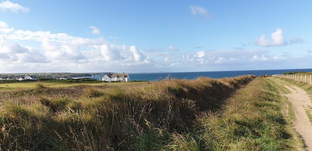
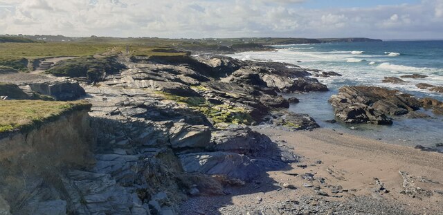
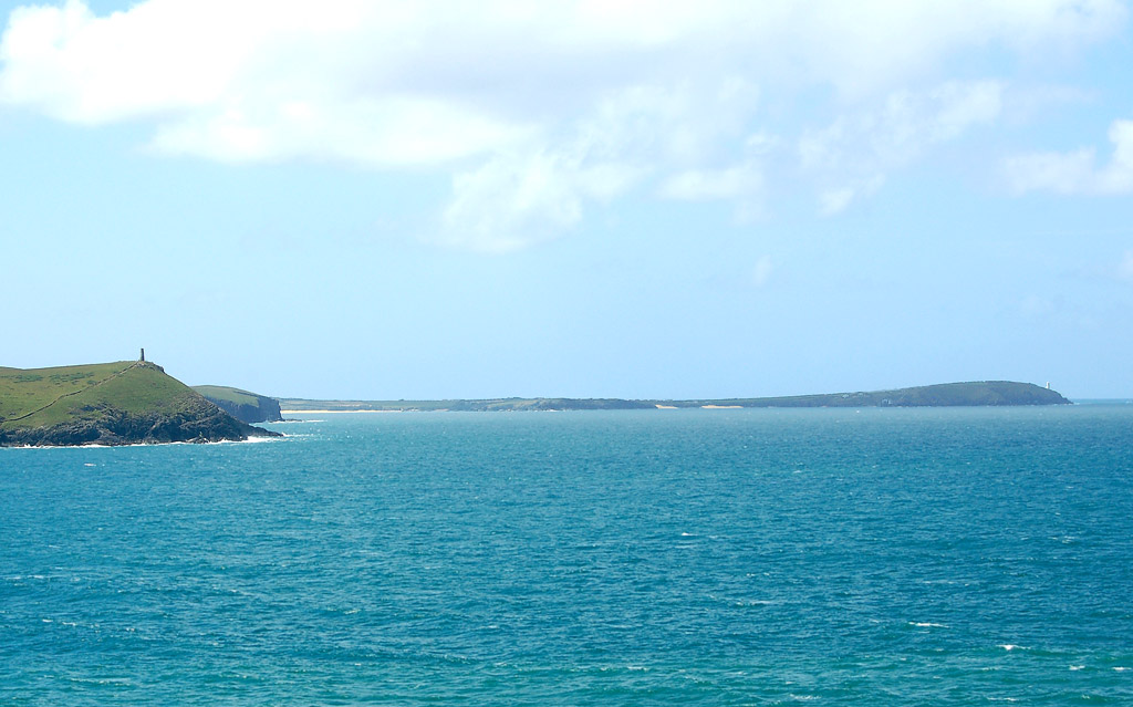
Booby's Bay is a secluded and picturesque beach located on the north coast of Cornwall, England. The bay is tucked away between the popular tourist destinations of Padstow and Newquay, making it a hidden gem for those seeking a quieter and more peaceful experience.

The beach at Booby's Bay is known for its golden sands and clear blue waters, making it an ideal spot for swimming, sunbathing, and relaxing. The bay is also popular with surfers, thanks to its consistent waves and uncrowded lineup.

Surrounded by towering cliffs and rugged headlands, Booby's Bay offers stunning views of the Atlantic Ocean and is a great place for coastal walks and exploring the natural beauty of Cornwall. The bay is also home to a variety of seabirds and marine life, making it a haven for wildlife enthusiasts.

Although Booby's Bay is somewhat off the beaten path, it is well worth the visit for those looking to escape the crowds and immerse themselves in the natural beauty of Cornwall's coastline.

If you have any feedback on the listing, please let us know in the comments section below.

Booby's Bay Images

Images are sourced within 2km of 50.538284/-5.0274322 or Grid Reference SW8575. Thanks to Geograph Open Source API. All images are credited.

Trevose Head Trig Pillar
Trevose Head Trig Pillar - Flush bracket S1735 Trevose Head Triangulation Pillar - Flush bracket S1735
Trevose Head Trig Pillar - Flush bracket S1735
Trevose Head Triangulation Pillar - Flush bracket S1735
The road to Trevose Head
Offshore Rocks and the Lighthouse at Trevose Head Looking past the Quies Rocks towards the Trevose Lighthouse a Grade II listed building dating from 1847 (Historic England List Entry No:1212769 <span class="nowrap"><a title="https://historicengland.org.uk/listing/the-list/list-entry/1212769?section=official-list-entry" rel="nofollow ugc noopener" href="https://historicengland.org.uk/listing/the-list/list-entry/1212769?section=official-list-entry">Link</a><img style="margin-left:2px;" alt="External link" title="External link - shift click to open in new window" src="https://s1.geograph.org.uk/img/external.png" width="10" height="10"/></span> ).
Offshore Rocks and the Lighthouse at Trevose Head
Looking past the Quies Rocks towards the Trevose Lighthouse a Grade II listed building dating from 1847 (Historic England List Entry No:1212769 LinkExternal link ).
Trevose Lighthouse Trevose Head Lighthouse was built by Trinity House in 1847 as a guide for vessels in the Bristol Channel. It is situated on the north west extremity of Trevose Head, with gigantic cliffs of grey granite rising sheer from the sea to a height of 150 feet or more. The area, like so much of the Devon and Cornwall coastline, is frequently obscured by sea mists (<span class="nowrap"><a title="https://www.trinityhouse.co.uk/lighthouses-and-lightvessels/trevose-head" rel="nofollow ugc noopener" href="https://www.trinityhouse.co.uk/lighthouses-and-lightvessels/trevose-head">Link</a><img style="margin-left:2px;" alt="External link" title="External link - shift click to open in new window" src="https://s1.geograph.org.uk/img/external.png" width="10" height="10"/></span> Trinity House).

The lighthouse is a Grade II listed building (Historic England List Entry No:1212769 <span class="nowrap"><a title="https://historicengland.org.uk/listing/the-list/list-entry/1212769?section=official-list-entry" rel="nofollow ugc noopener" href="https://historicengland.org.uk/listing/the-list/list-entry/1212769?section=official-list-entry">Link</a><img style="margin-left:2px;" alt="External link" title="External link - shift click to open in new window" src="https://s1.geograph.org.uk/img/external.png" width="10" height="10"/></span> ).
Trevose Lighthouse
Trevose Head Lighthouse was built by Trinity House in 1847 as a guide for vessels in the Bristol Channel. It is situated on the north west extremity of Trevose Head, with gigantic cliffs of grey granite rising sheer from the sea to a height of 150 feet or more. The area, like so much of the Devon and Cornwall coastline, is frequently obscured by sea mists (LinkExternal link Trinity House). The lighthouse is a Grade II listed building (Historic England List Entry No:1212769 LinkExternal link ).
St Constantine's Well
St Constantine well
St Constantine well
Walk Towards Booby's Bay A view from the path from the car park down to Booby's Bay.
Walk Towards Booby's Bay
A view from the path from the car park down to Booby's Bay.
Fields at Booby's Bay The fields to the north of the path down to Booby's Bay from the car park. You can just see a glimpse of the sea on the horizon.
Fields at Booby's Bay
The fields to the north of the path down to Booby's Bay from the car park. You can just see a glimpse of the sea on the horizon.
The Sea at Booby's Bay Looking down from the cliff at the sea breaking on rocks at Booby's Bay.
The Sea at Booby's Bay
Looking down from the cliff at the sea breaking on rocks at Booby's Bay.
High Tide at Booby's Bay Looking across Booby's Bay towards Constantine Bay and Treyarnon.
High Tide at Booby's Bay
Looking across Booby's Bay towards Constantine Bay and Treyarnon.
Cliff Path at Booby's Bay A cliff top path at Booby's Bay, looking out over the breaking waves.
Cliff Path at Booby's Bay
A cliff top path at Booby's Bay, looking out over the breaking waves.
Rocks at Booby's Bay The sea breaking on rocks at Booby's Bay.
Rocks at Booby's Bay
The sea breaking on rocks at Booby's Bay.
Gentle Cliffs at Booby's Bay The sea breaking on the cliffs and rocks at Booby's Bay.
Gentle Cliffs at Booby's Bay
The sea breaking on the cliffs and rocks at Booby's Bay.
Rocks towards Treyarnon, Booby's Bay Viewed from the very edge of the cliff, the rocks at Booby's Bay, looking towards Treyarnon on the horizon.
Rocks towards Treyarnon, Booby's Bay
Viewed from the very edge of the cliff, the rocks at Booby's Bay, looking towards Treyarnon on the horizon.
Booby's Bay from Cliff Edge Rocks and steep pebble beach at Booby's Bay from the edge of the cliff.
Booby's Bay from Cliff Edge
Rocks and steep pebble beach at Booby's Bay from the edge of the cliff.
Constantine Bay Stores
Leaving Constantine Bay and passing Trevose Golf Club
Show me another place!

Booby's Bay is located at Grid Ref: SW8575 (Lat: 50.538284, Lng: -5.0274322)

Unitary Authority: Cornwall

Police Authority: Devon and Cornwall

What 3 Words

///however.matchbox.boards. Near Padstow, Cornwall

Related Wikis

Booby's Bay

Booby's Bay is a sandy beach near Padstow, Cornwall, England, UK. During World War I, the three masted sailing ship Carl of the German navy was beached...
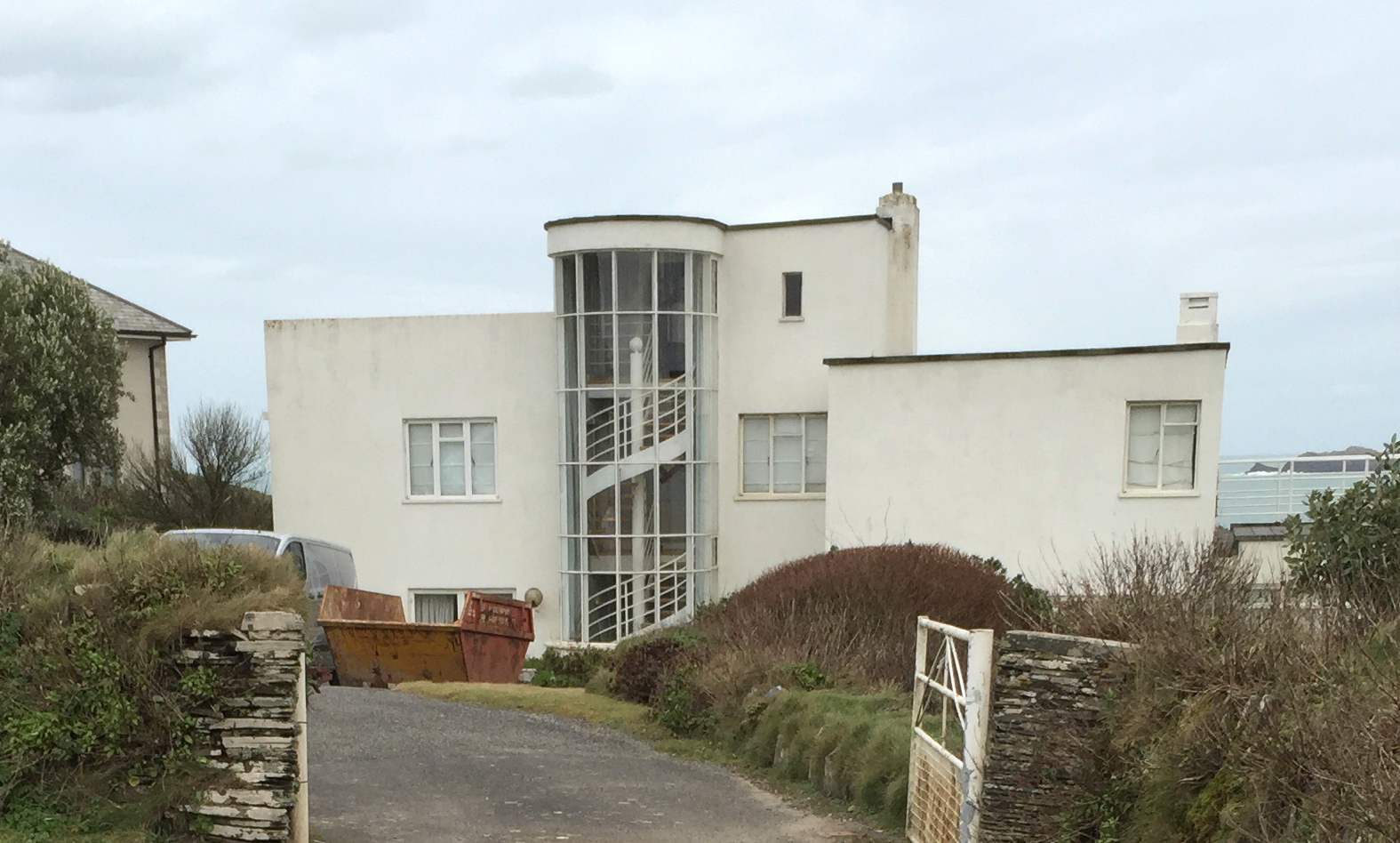
Polventon House

Polventon House is a grade II listed private house overlooking Mother Ivey's Bay near Padstow in Cornwall, England. It was built in the International Style...

Trevose Head

Trevose Head (Cornish: Penn Trenfos, meaning farm of the wall's headland) (grid reference SW853764) is a headland on the Atlantic coast of north Cornwall...

Mother Ivy's Bay

Polventon Bay (Cornish: Poll Fenton, meaning pool of a spring), Mother Ivey's Bay is a bay and bathing beach on the north coast of Cornwall, United Kingdom...

Nearby Amenities

Located within 500m of 50.538284,-5.0274322
Source: PGS
Lat/Long: 50.5402633/-5.0276119
Source: PGS
Lat/Long: 50.5394519/-5.0253552
Source: PGS
Lat/Long: 50.5395195/-5.0249945
Source: PGS
Lat/Long: 50.5395945/-5.0247437
Source: PGS
Lat/Long: 50.5391888/-5.0254853
Source: PGS
Lat/Long: 50.5387234/-5.0247223
Source: PGS
Lat/Long: 50.5386118/-5.0249543
Source: PGS
Lat/Long: 50.536717/-5.023514
Source: PGS
Lat/Long: 50.5361885/-5.0226932
Barrier: kissing_gate
Lat/Long: 50.5418174/-5.0260141
Golf: pin
Lat/Long: 50.5381077/-5.023746
Constantine Island
Place: locality
Lat/Long: 50.53669/-5.02511
Bench
Backrest: yes
Lat/Long: 50.5420665/-5.0296367
Bench
Backrest: yes
Lat/Long: 50.5407938/-5.0251397
Bench
Backrest: yes
Lat/Long: 50.54194/-5.0267333
Life Ring
Emergency: life_ring
Survey Date: 2023-02-12
Lat/Long: 50.5387536/-5.0240824
Life Ring
Emergency: life_ring
Survey Date: 2023-02-12
Lat/Long: 50.5373808/-5.0246237
Bench
Backrest: yes
Survey Date: 2023-02-12
Lat/Long: 50.5418974/-5.0261741
Phone
Emergency: phone
Lat/Long: 50.5381567/-5.024312
The data included in this document is from www.openstreetmap.org. The data is made available under ODbL.

Have you been to Booby's Bay?

Leave your review of Booby's Bay below (or comments, questions and feedback).