An Dubh-Chamas

Bay in Inverness-shire

Scotland

An Dubh-Chamas

Torr nan Gamhainn A low wooded hill on the south west shore of Loch Nevis. There are signs of old cultivation and improved ground here, but all human activity has ceased. The view seen from the MV Western Isles as she glides by.
Torr nan Gamhainn Credit: Gordon Hatton

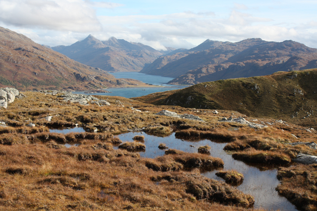
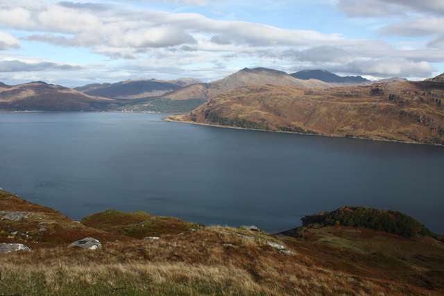
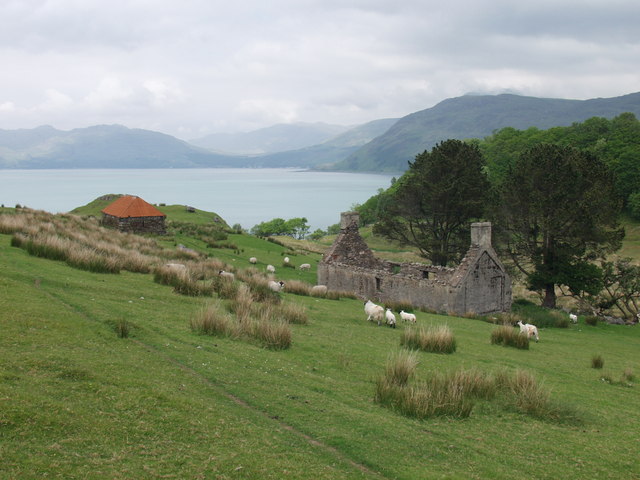
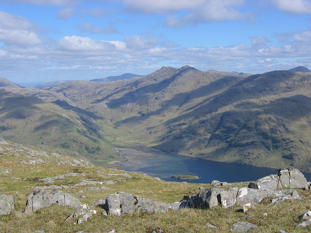
An Dubh-Chamas, located in Inverness-shire, Scotland, is a picturesque bay nestled along the rugged coastline of the Scottish Highlands. The bay is known for its stunning views of the surrounding mountains and clear blue waters, making it a popular destination for tourists and locals alike.

The name "An Dubh-Chamas" translates to "the black bay" in Gaelic, a fitting description of the dark, pebbled shoreline that lines the bay. The bay is also home to a variety of wildlife, including seabirds, seals, and occasionally dolphins, making it a great spot for birdwatching and wildlife enthusiasts.

Visitors to An Dubh-Chamas can enjoy activities such as hiking along the coastal trails, kayaking in the calm waters, or simply relaxing on the beach and taking in the tranquil atmosphere. The bay is also a great spot for picnicking or camping, with several designated spots for visitors to set up camp and enjoy a night under the stars.

Overall, An Dubh-Chamas is a hidden gem along the Scottish coast, offering a peaceful retreat for those looking to escape the hustle and bustle of city life and immerse themselves in the natural beauty of the Highlands.

If you have any feedback on the listing, please let us know in the comments section below.

An Dubh-Chamas Images

Images are sourced within 2km of 56.991858/-5.70747 or Grid Reference NM7495. Thanks to Geograph Open Source API. All images are credited.

Torr nan Gamhainn A low wooded hill on the south west shore of Loch Nevis. There are signs of old cultivation and improved ground here, but all human activity has ceased. The view seen from the MV Western Isles as she glides by.
Torr nan Gamhainn
A low wooded hill on the south west shore of Loch Nevis. There are signs of old cultivation and improved ground here, but all human activity has ceased. The view seen from the MV Western Isles as she glides by.
Former settlement at Stoul Various ruins dot the shoreline here, whilst there are traces of old runrig cultivation on the lower slopes of the hillside. The OS 6" map of 1873 doesn't offer much more in the way of information as there are no contours shown, although there seem to be several buildings and a boundary to cultivated areas. Interesting to see that a few miles further along the loch, there is both a school and an inn shown at Tarbet. Can't be sure about the camera location, but the skipper of the ferry was being obliging by sailing a little nearer the shore than usual.
Former settlement at Stoul
Various ruins dot the shoreline here, whilst there are traces of old runrig cultivation on the lower slopes of the hillside. The OS 6" map of 1873 doesn't offer much more in the way of information as there are no contours shown, although there seem to be several buildings and a boundary to cultivated areas. Interesting to see that a few miles further along the loch, there is both a school and an inn shown at Tarbet. Can't be sure about the camera location, but the skipper of the ferry was being obliging by sailing a little nearer the shore than usual.
Western shore of Loch Nevis Apart from a vessel servicing a local fish farm, there's little sign of human activity along this remote shoreline.
Western shore of Loch Nevis
Apart from a vessel servicing a local fish farm, there's little sign of human activity along this remote shoreline.
Torr nan Gamhainn From Loch Nevis
Ruins of Stoul These sad ruins sit beneath a hill path which links Lochs Nevis and Morar via the Bealach nan Sac.
Ruins of Stoul
These sad ruins sit beneath a hill path which links Lochs Nevis and Morar via the Bealach nan Sac.
Lochan Stole beach I had a fantastic days fishing from here and saw my first sea eagle.
Lochan Stole beach
I had a fantastic days fishing from here and saw my first sea eagle.
Lochan Stole
Lochan Stole
Lochan Ropach & Lochan Stole The stepping stones mark the dividing line between the two lochans.
Lochan Ropach & Lochan Stole
The stepping stones mark the dividing line between the two lochans.
Lochan Stole from the stepping stones
Lochan Stole From slopes above the east bank.
Lochan Stole
From slopes above the east bank.
Lochan Ròpach Seen from slopes to the east.
Lochan Ròpach
Seen from slopes to the east.
Lochan nan Uan A large lochan with an area of boggy ground at the southern end.
Lochan nan Uan
A large lochan with an area of boggy ground at the southern end.
Bogs, Druim Bealach nan Sac Looking towards Loch Nevis.
Bogs, Druim Bealach nan Sac
Looking towards Loch Nevis.
View north from Druim Bealach nan Sac Looking across Loch Nevis to Inverie and the Knoydart hills.
View north from Druim Bealach nan Sac
Looking across Loch Nevis to Inverie and the Knoydart hills.
View east from Druim Bealach nan Sac This little hill above the path to Stoul is a great viewpoint.  Looking along Loch Nevis towards the narrows.
View east from Druim Bealach nan Sac
This little hill above the path to Stoul is a great viewpoint. Looking along Loch Nevis towards the narrows.
Lochan Stole A view of Lochan Stole, behind the pass of Bealach nan Sac the peak of Sgurr Coire nan Gobhar can be seen in the far distance.
Lochan Stole
A view of Lochan Stole, behind the pass of Bealach nan Sac the peak of Sgurr Coire nan Gobhar can be seen in the far distance.
Stepping stones on the Stoul path The path to Stoul from Loch Morar crosses Lochan Stole and Lochan Ropach by these stepping stones.
Stepping stones on the Stoul path
The path to Stoul from Loch Morar crosses Lochan Stole and Lochan Ropach by these stepping stones.
Derelict Cottage at Easter Stoul A derelict set of buildings near to the shore of Loch Nevis.
Derelict Cottage at Easter Stoul
A derelict set of buildings near to the shore of Loch Nevis.
Show me another place!

An Dubh-Chamas is located at Grid Ref: NM7495 (Lat: 56.991858, Lng: -5.70747)

Unitary Authority: Highland

Police Authority: Highlands and Islands

What 3 Words

///downward.zone.registers. Near Arisaig, Highland

Nearby Locations

An Dubh-Chamas

Related Wikis

Loch Nevis

Loch Nevis (Scottish Gaelic: Loch Nibheis) is a sea loch in Lochaber on the west coast of Scotland. It runs inland from the Sound of Sleat, and is bounded...

Bracorina

Bracorina is a settlement in Lochaber, in the Highland council area of Scotland. It is located on the northern side of Loch Morar, 5 km east of the village...

Inverie Bay

Inverie Bay is a coastal embayment, on a chord of 2.12 miles, on a 207° orientation, on the northwestern coast of the sea loch in Loch Nevis, and is next...

Bracora

Bracora is a settlement in Lochaber in the Highlands of Scotland. It lies on the north shore of Loch Morar.

Have you been to An Dubh-Chamas?

Leave your review of An Dubh-Chamas below (or comments, questions and feedback).