Acarsaid Bheag

Bay in Argyllshire

Scotland

Acarsaid Bheag

Rounding Rubha na h-Earba into Sailean na h-Earba Rounding the gently curving NW shore of Rubha na h-Earba gives us our first view of the islands we will pass before Carsaig Bay (our intended lunch stop). The rocky promontory now on our left is Rubha na h-Airde Loisgte. Visibility is starting to improve (earlier, cloudbase had seemed scarcly above head height) as the ebb tide assists our paddle SW down the Sound of Jura.
Rounding Rubha na h-Earba into Sailean na h-Earba Credit: Andy Waddington

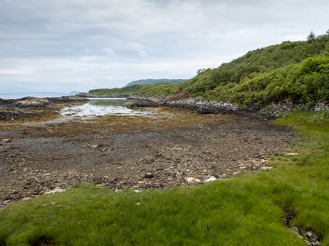
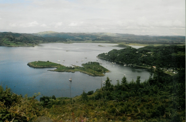
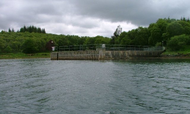
Acarsaid Bheag, located in Argyllshire, Scotland, is a picturesque bay known for its natural beauty and serene atmosphere. Nestled along the western coast of Scotland, the bay offers stunning views of the surrounding landscape, including rolling hills, lush greenery, and the sparkling waters of the Atlantic Ocean.

The bay is a popular destination for nature enthusiasts and outdoor enthusiasts alike. Its tranquil waters provide a perfect spot for various water activities such as sailing, kayaking, and fishing. The bay is also home to a wide variety of marine life, making it a great spot for wildlife watching and diving.

The surrounding area of Acarsaid Bheag offers numerous walking trails and hiking routes, allowing visitors to explore the scenic countryside and take in the breathtaking views. The bay is also a gateway to other attractions in Argyllshire, including ancient castles, historic sites, and charming villages.

The village near Acarsaid Bheag offers a range of amenities and services to cater to visitors' needs, including accommodation options such as cozy bed and breakfasts and self-catering cottages. There are also several cafes and restaurants where visitors can enjoy a meal or a cup of coffee while admiring the bay's idyllic scenery.

Overall, Acarsaid Bheag in Argyllshire is a hidden gem that offers a peaceful retreat from the hustle and bustle of city life. With its natural beauty, outdoor activities, and charming surroundings, it is a must-visit destination for those seeking tranquility and a connection with nature.

If you have any feedback on the listing, please let us know in the comments section below.

Acarsaid Bheag Images

Images are sourced within 2km of 56.057192/-5.624472 or Grid Reference NR7490. Thanks to Geograph Open Source API. All images are credited.

Rounding Rubha na h-Earba into Sailean na h-Earba Rounding the gently curving NW shore of Rubha na h-Earba gives us our first view of the islands we will pass before Carsaig Bay (our intended lunch stop). The rocky promontory now on our left is Rubha na h-Airde Loisgte. Visibility is starting to improve (earlier, cloudbase had seemed scarcly above head height) as the ebb tide assists our paddle SW down the Sound of Jura.
Rounding Rubha na h-Earba into Sailean na h-Earba
Rounding the gently curving NW shore of Rubha na h-Earba gives us our first view of the islands we will pass before Carsaig Bay (our intended lunch stop). The rocky promontory now on our left is Rubha na h-Airde Loisgte. Visibility is starting to improve (earlier, cloudbase had seemed scarcly above head height) as the ebb tide assists our paddle SW down the Sound of Jura.
An Garadh Small trees and boulders dot the grassland below the cliffs of An Garadh: Caol Scotnish and Loch Sween beyond
An Garadh
Small trees and boulders dot the grassland below the cliffs of An Garadh: Caol Scotnish and Loch Sween beyond
Birch wood, Ardnackaig Hillside in Knapdale Forest after removal of conifers.
Birch wood, Ardnackaig
Hillside in Knapdale Forest after removal of conifers.
Pond, Ardnackaig
Pond, Ardnackaig
Sàilen Mòr and Rubha nam Bàrr The long parallel ridges of Knapdale often form narrow sharp headlands like Rubha nam Bàrr. This is the only encounter with the shoreline on the road north of Carsaig.
Sàilen Mòr and Rubha nam Bàrr
The long parallel ridges of Knapdale often form narrow sharp headlands like Rubha nam Bàrr. This is the only encounter with the shoreline on the road north of Carsaig.
Sàilen Mòr An inlet, backed by the emerging birchwoods.
Sàilen Mòr
An inlet, backed by the emerging birchwoods.
Forest road, Dounie Forms the bulk of a walking route between Carsaig and Crinan Harbour. There is a garden bonfire at Dounie.
Forest road, Dounie
Forms the bulk of a walking route between Carsaig and Crinan Harbour. There is a garden bonfire at Dounie.
Pond near Dounie Right on the shoreline.
Pond near Dounie
Right on the shoreline.
Rubha nam Bàrr A sharp headland with Jura beyond.
Rubha nam Bàrr
A sharp headland with Jura beyond.
Coast, Dounie The wooded coast of Knapdale.
Coast, Dounie
The wooded coast of Knapdale.
Ridge above Dounie The steep slopes contain woodland which has both predated and survived the Forestry Commission's planting of the area.
Ridge above Dounie
The steep slopes contain woodland which has both predated and survived the Forestry Commission's planting of the area.
Ruin beneath Suidhe Bhaird Near Dounie and beside the road.
Ruin beneath Suidhe Bhaird
Near Dounie and beside the road.
Road near Dounie Forms the bulk of a walking route between Carsaig and Crinan Harbour.
Road near Dounie
Forms the bulk of a walking route between Carsaig and Crinan Harbour.
Track into the forest At this point, I'm hoping to find a route up onto Cnoc Reamhar.
Reader, I succeeded.
Track into the forest
At this point, I'm hoping to find a route up onto Cnoc Reamhar. Reader, I succeeded.
Passing yacht in the Sound of Jura Looking across the reef of Rubha Caol, which forms a sheltered harbour at Ardnackaig. The lighthouse is on the skerry of Ruadh Sgeir.
Passing yacht in the Sound of Jura
Looking across the reef of Rubha Caol, which forms a sheltered harbour at Ardnackaig. The lighthouse is on the skerry of Ruadh Sgeir.
Small bay at Ardnackaig This sheltered harbour is formed by Rudha Caol to the left.
Small bay at Ardnackaig
This sheltered harbour is formed by Rudha Caol to the left.
Head of the bay at Ardnackaig
Small bay at Ardnackaig A sheltered harbour formed by Rudha Caol to the left.
Small bay at Ardnackaig
A sheltered harbour formed by Rudha Caol to the left.
Show me another place!

Acarsaid Bheag is located at Grid Ref: NR7490 (Lat: 56.057192, Lng: -5.624472)

Unitary Authority: Argyll and Bute

Police Authority: Argyll and West Dunbartonshire

What 3 Words

///collision.trading.applies. Near Ardrishaig, Argyll & Bute

Nearby Locations

Rubha Caol Acarsaid Bheag

Related Wikis

Tayvallich

Tayvallich (pronounced TAY-vee-AL-ich; Scottish Gaelic: Taigh a' Bhealaich [t̪ʰɤj ə ˈvjal̪ˠɪç]) is a small village in the Knapdale area of Argyll and Bute...

Achnamara

Achnamara (Scottish Gaelic: Achadh na Mara) is a village in the Scottish council area of Argyll and Bute. Its location is approximately 56°1' N 5°34' W...

Eilean dà Mhèinn

Eilean dà Mhèinn, is a small inhabited island in Loch Crinan and one of the Inner Hebrides of Scotland. It is about 100 metres (330 ft) to the west of...

Eilean Loain

Eilean Loain is a small island in Loch Sween and one of the Inner Hebrides of Scotland. It is about 2 kilometres (1 mi) west of the settlement of Kilmichael...

Nearby Amenities

Located within 500m of 56.057192,-5.624472
Power: pole
Lat/Long: 56.0530331/-5.624099
Power: pole
Lat/Long: 56.0537811/-5.624015
The data included in this document is from www.openstreetmap.org. The data is made available under ODbL.

Have you been to Acarsaid Bheag?

Leave your review of Acarsaid Bheag below (or comments, questions and feedback).