Sydney Cove

Bay in Cornwall

England

Sydney Cove

OS Cut Mark: Germoe, Larkspur Cottage <span class="nowrap"><a title="https://www.bench-marks.org.uk/bm85462" rel="nofollow ugc noopener" href="https://www.bench-marks.org.uk/bm85462">Link</a><img style="margin-left:2px;" alt="External link" title="External link - shift click to open in new window" src="https://s1.geograph.org.uk/img/external.png" width="10" height="10"/></span>
OS Cut Mark: Germoe, Larkspur Cottage Credit: thejackrustles

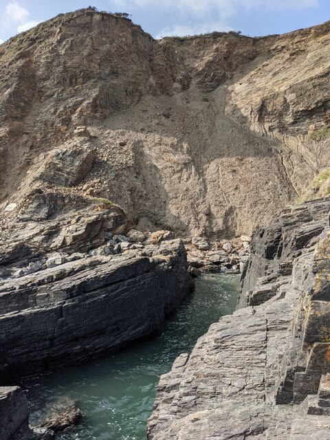
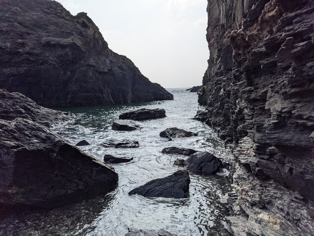
Sydney Cove, Cornwall, also known as Sydney Cove Bay, is a picturesque cove located on the south coast of Cornwall, England. The cove is renowned for its stunning natural beauty, with clear blue waters, golden sandy beaches, and towering cliffs surrounding the area. The bay is a popular destination for tourists and locals alike, offering a peaceful and tranquil setting for swimming, sunbathing, and exploring.

Sydney Cove is also known for its rich history, as it was once a bustling harbor for fishing and trade in the 18th and 19th centuries. Today, visitors can still see remnants of the old fishing village that once thrived in the area, including historic buildings and fishing boats.

The cove is also a great spot for outdoor activities such as hiking, birdwatching, and fishing. The surrounding cliffs offer breathtaking views of the coastline, making it a popular spot for photographers and nature enthusiasts.

Overall, Sydney Cove, Cornwall is a must-visit destination for those looking to experience the natural beauty and rich history of the Cornish coast.

If you have any feedback on the listing, please let us know in the comments section below.

Sydney Cove Images

Images are sourced within 2km of 50.10283/-5.3922688 or Grid Reference SW5728. Thanks to Geograph Open Source API. All images are credited.

OS Cut Mark: Germoe, Larkspur Cottage <span class="nowrap"><a title="https://www.bench-marks.org.uk/bm85462" rel="nofollow ugc noopener" href="https://www.bench-marks.org.uk/bm85462">Link</a><img style="margin-left:2px;" alt="External link" title="External link - shift click to open in new window" src="https://s1.geograph.org.uk/img/external.png" width="10" height="10"/></span>
OS Cut Mark: Germoe, Larkspur Cottage
Prussia Cove
Prussia Cove
Looking down on Kenneggy Sand
Looking along Kenneggy Cliff  From the old mine.
Looking along Kenneggy Cliff
From the old mine.
The old mine above Kenneggy Sand
The footpath near the old mine
Farm tracks and footpaths A complicated junction on the way to the Coast Path.
Farm tracks and footpaths
A complicated junction on the way to the Coast Path.
The entrance to Higher Kenneggy wild camping site
Higher Kenneggy wild campsite Very few facilities, if not exactly 'wild'.
Higher Kenneggy wild campsite
Very few facilities, if not exactly 'wild'.
Coastal rocks near Pestreath Cove
The Coast Path near Pestreath Cove The path just passes through the corner of this square.
The Coast Path near Pestreath Cove
The path just passes through the corner of this square.
A hidden archway at Hoe Point This is a complex area of channels and stacks, not often accessed except by fishermen.
A hidden archway at Hoe Point
This is a complex area of channels and stacks, not often accessed except by fishermen.
The entrance to the zawn at Hoe Point The red rope and steel staples in the rock are an aid for the fishermen's access to the water.
The entrance to the zawn at Hoe Point
The red rope and steel staples in the rock are an aid for the fishermen's access to the water.
Narrow zawn, crumbling cliff At Hoe Point.
Narrow zawn, crumbling cliff
At Hoe Point.
Looking out along the channel An interesting zawn in the rocks, used somehow by fishermen.
Looking out along the channel
An interesting zawn in the rocks, used somehow by fishermen.
Shattered rocks at Hoe Point
Looking past Little Castle Towards Praa Sands.
Looking past Little Castle
Towards Praa Sands.
The Coast Path above Sydney Cove
Show me another place!

Sydney Cove is located at Grid Ref: SW5728 (Lat: 50.10283, Lng: -5.3922688)

Unitary Authority: Cornwall

Police Authority: Devon and Cornwall

What 3 Words

///wire.enacted.cassettes. Near Germoe, Cornwall

Nearby Locations

Sydney Cove

Related Wikis

Praa Sands

Praa Sands (Cornish: Poll an Wragh = Salt Pool of the Wrasse), (formerly Prah Sands) commonly pronounced pray or prah, is a white-sand beach and coastal...
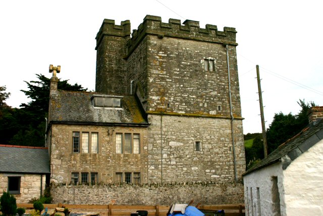
Pengersick Castle

Pengersick Castle is a fortified manor house located between the villages of Germoe and Praa Sands in Cornwall, England. The tower house, which is in the...

Newtown, Cornwall

Newtown is a hamlet in the parish of Germoe, Cornwall, England. == References ==

Kenneggy

Kenneggy comprises two separate hamlets, Higher Kenneggy (Cornish: Keunegi Wartha) to the west and Lower Kennegy (Cornish: Keunegi Woles) to the east,...

Nearby Amenities

Located within 500m of 50.10283,-5.3922688
Source: PGS
Lat/Long: 50.1003215/-5.3974601
Source: PGS
Lat/Long: 50.1006534/-5.3971999
Source: PGS
Lat/Long: 50.1008428/-5.3968354
Created By: almien_coastlines
Source: PGS
Lat/Long: 50.100885/-5.396486
Created By: almien_coastlines
Source: PGS
Lat/Long: 50.101017/-5.396295
Source: PGS
Lat/Long: 50.1011597/-5.3956512
Source: PGS
Lat/Long: 50.1015611/-5.3952296
Source: PGS
Lat/Long: 50.1018832/-5.3949781
Source: PGS
Lat/Long: 50.1020492/-5.3950376
Source: PGS
Lat/Long: 50.1022715/-5.3946887
Source: PGS
Lat/Long: 50.1026987/-5.3941455
Source: PGS
Lat/Long: 50.1027201/-5.3930575
Source: PGS
Lat/Long: 50.102153/-5.390208
Source: PGS
Lat/Long: 50.1018234/-5.388986
Source: PGS
Lat/Long: 50.1012247/-5.387117
Bus Stop
Parc Morrep
Bench: no
Bus: yes
Naptan AtcoCode: 0800COD40600
Naptan Bearing: N
Naptan CommonName: Parc Morrep
Naptan Crossing: Castle Drive
Naptan NaptanCode: coragwgw
Naptan Street: Parc Morrep
Naptan Verified: no
Public Transport: platform
Shelter: no
Source: naptan_import
Lat/Long: 50.1044539/-5.3893
Bus Stop
Parc Morrep
Bench: no
Bus: yes
Naptan AtcoCode: 0800COD40601
Naptan Bearing: N
Naptan CommonName: Parc Morrep
Naptan Crossing: Castle Drive
Naptan NaptanCode: coragwja
Naptan Street: Parc Morrep
Naptan Verified: no
Public Transport: platform
Shelter: no
Source: naptan_import
Lat/Long: 50.1045232/-5.3894214
Post Box
Brand: Royal Mail
Brand Wikidata: Q638098
Collection Times: Mo-Fr 11:00; Sa 11:00; Su off
Drive Through: no
Operator: Royal Mail
Operator Wikidata: Q638098
Post Box Mounting: pier
Post Box Type: lamp
Ref: TR20 44
Royal Cypher: EIIR
Royal Cypher Wikidata: Q33102113
Source: survey;streetlevel imagery;aerial imagery
Survey Date: 2022-07-17
Lat/Long: 50.1042973/-5.3918984
Pub
The SandBar
Lat/Long: 50.1038916/-5.391816
Cafe
Lat/Long: 50.1038017/-5.3909281
RAAF Sunderland Flying Boat
Historic: memorial
Material: stone
Memorial: war_memorial
Lat/Long: 50.1031966/-5.3867949
Bench
Backrest: no
Lat/Long: 50.103142/-5.3869505
Information: board
Tourism: information
Lat/Long: 50.1031364/-5.3868996
Man Made: mast
Lat/Long: 50.105929/-5.3966689
Generator Method: photovoltaic
Generator Output Electricity: small_installation
Generator Source: solar
Generator Type: solar_photovoltaic_panel
Location: roof
Power: generator
Source: bing
Lat/Long: 50.1044019/-5.3907895
Generator Method: photovoltaic
Generator Output Electricity: small_installation
Generator Source: solar
Generator Type: solar_photovoltaic_panel
Location: roof
Power: generator
Source: bing
Lat/Long: 50.1056044/-5.3895369
Generator Method: photovoltaic
Generator Output Electricity: small_installation
Generator Source: solar
Generator Type: solar_photovoltaic_panel
Location: roof
Power: generator
Source: bing
Lat/Long: 50.1053971/-5.3869861
WW2 Roadblock (site of)
Historic: yes
Lat/Long: 50.1038459/-5.3921044
Barrier: block
Lat/Long: 50.1017093/-5.3981011
Bench
Backrest: yes
Survey Date: 2022-07-17
Lat/Long: 50.1036396/-5.3955559
Defibrillator
Defibrillator Location: On outside wall of The SandBar, facing car park
Emergency: defibrillator
Indoor: no
Survey Date: 2022-07-17
Lat/Long: 50.1040435/-5.3918508
Life Ring
Emergency: life_ring
Survey Date: 2022-07-17
Lat/Long: 50.1038045/-5.3920563
Grit Bin
Survey Date: 2022-07-17
Lat/Long: 50.1048645/-5.3914487
Fire Hydrant
Emergency: fire_hydrant
Fire Hydrant Diameter: 100
Fire Hydrant Position: lane
Fire Hydrant Type: underground
Survey Date: 2022-07-17
Lat/Long: 50.1046051/-5.3918304
Life Ring
Emergency: life_ring
Survey Date: 2022-09-04
Lat/Long: 50.1028184/-5.3870683
Life Ring
Emergency: life_ring
Survey Date: 2022-09-04
Lat/Long: 50.1035001/-5.3897132
Life Ring
Emergency: life_ring
Survey Date: 2022-09-04
Lat/Long: 50.1037341/-5.3907667
Fire Hydrant
Emergency: fire_hydrant
Fire Hydrant Type: underground
Survey Date: 2022-09-04
Lat/Long: 50.1040977/-5.3923584
Fire Hydrant
Emergency: fire_hydrant
Fire Hydrant Type: underground
Survey Date: 2022-09-04
Lat/Long: 50.1045043/-5.3893126
Leisure: fitness_station
Sport: fitness
Lat/Long: 50.1038103/-5.3859223
Leisure: pitch
Sport: basketball
Lat/Long: 50.1037429/-5.385916
Bus Stop
Bus: yes
Public Transport: platform
Lat/Long: 50.1046275/-5.3868758
The data included in this document is from www.openstreetmap.org. The data is made available under ODbL.

Have you been to Sydney Cove?

Leave your review of Sydney Cove below (or comments, questions and feedback).