Carsaig Bay

Bay in Argyllshire

Scotland

Carsaig Bay

Heading for Carsaig Bay The last section of the path from Loch Buie to Carsaig has reached relatively easy ground and by the next time that the shore gets rough and scrambly, it will bypass the difficulties via a pleasant path in the woods. This bit tends to lull walkers starting at Carsaig into something of a false sense of security, not realising how rough the route will become over its central section. Allow plenty of time.
Heading for Carsaig Bay Credit: Andy Waddington

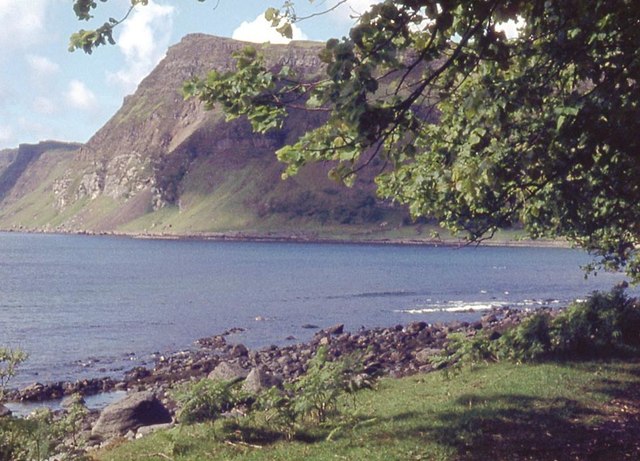
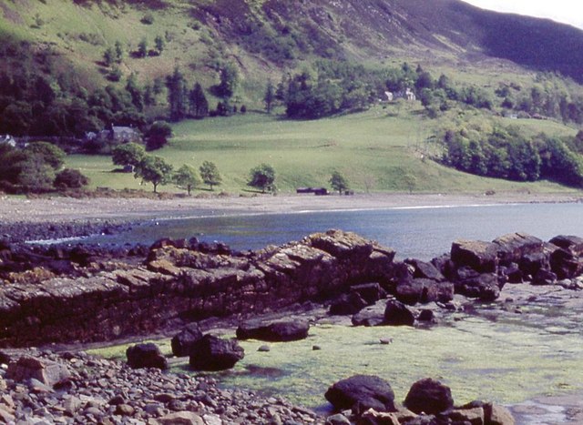
Carsaig Bay is a picturesque bay located on the southwestern coast of the Isle of Mull in Argyllshire, Scotland. It is renowned for its stunning natural beauty and diverse wildlife, attracting nature enthusiasts and visitors from all over the world.

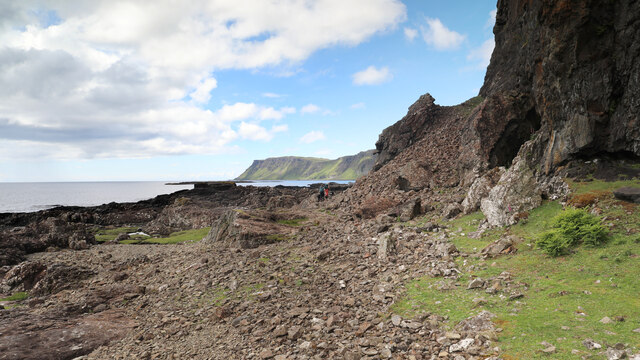
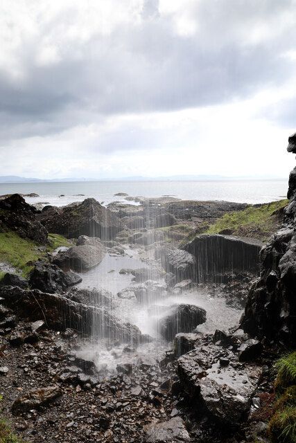
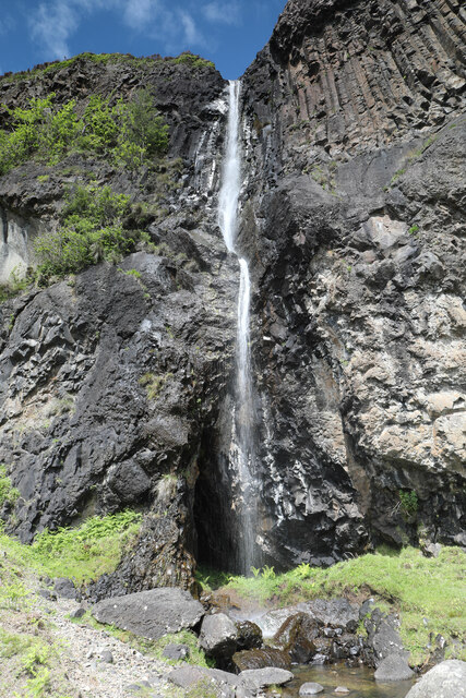
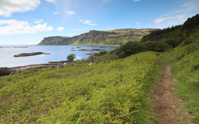
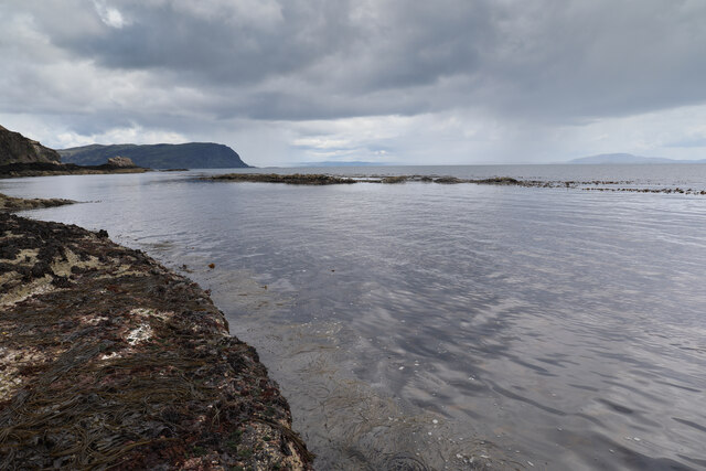
The bay is characterized by its rugged cliffs, towering sea stacks, and dramatic rock formations, which provide a breathtaking backdrop to its crystal-clear turquoise waters. The bay is also home to a beautiful sandy beach, perfect for relaxing and enjoying the scenic surroundings.

Carsaig Bay is not only visually appealing, but it is also a haven for wildlife. The area is known for its rich marine life, including seals, dolphins, and various seabird species. Birdwatchers can spot rare species such as golden eagles, puffins, and guillemots nesting on the cliffs.

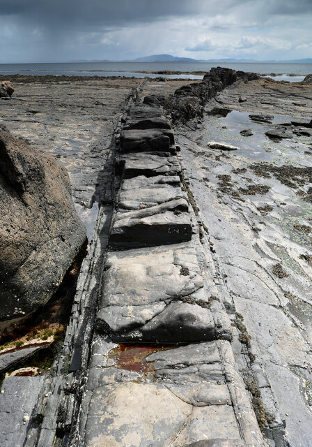
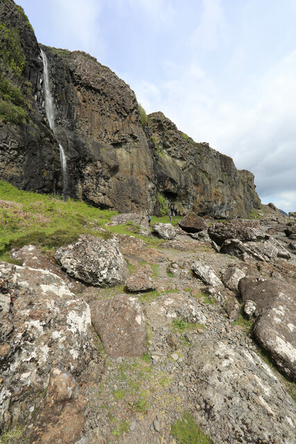
In addition to its natural wonders, Carsaig Bay holds historical significance. It is the site of the Carsaig Arches, a series of natural rock arches formed by erosion over thousands of years. These arches serve as a reminder of the area's geological history and attract geologists and geology enthusiasts.

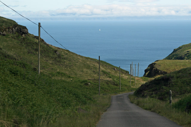
Visitors to Carsaig Bay can indulge in various outdoor activities such as hiking, birdwatching, and photography. The bay can be accessed by foot or by boat, and there are several walking trails that lead to stunning viewpoints overlooking the bay.

Overall, Carsaig Bay offers a unique and captivating experience for nature lovers, history enthusiasts, and those seeking tranquility amidst breathtaking scenery.

If you have any feedback on the listing, please let us know in the comments section below.
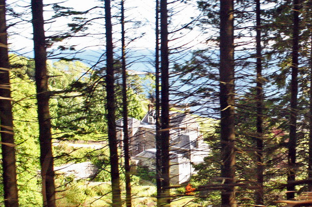
Carsaig Bay Images

Images are sourced within 2km of 56.320281/-5.9795041 or Grid Reference NM5421. Thanks to Geograph Open Source API. All images are credited.

Heading for Carsaig Bay The last section of the path from Loch Buie to Carsaig has reached relatively easy ground and by the next time that the shore gets rough and scrambly, it will bypass the difficulties via a pleasant path in the woods. This bit tends to lull walkers starting at Carsaig into something of a false sense of security, not realising how rough the route will become over its central section. Allow plenty of time.
Heading for Carsaig Bay
The last section of the path from Loch Buie to Carsaig has reached relatively easy ground and by the next time that the shore gets rough and scrambly, it will bypass the difficulties via a pleasant path in the woods. This bit tends to lull walkers starting at Carsaig into something of a false sense of security, not realising how rough the route will become over its central section. Allow plenty of time.
Through the waterfall at Carraig Mhòr Beyond the entrance to Loch Buie, the coast path to Carsaig looks out over more extensive water - the Firth of Lorne. By scrambling behind the waterfall (which can be done without getting wet, at least in this weather) the view can include water closer to hand, made a little more visible with a 1/10 second exposure. This is one of the higher waterfalls along the route, and isn't cut into such a deep notch in the cliffs as some of the others, as can be seen looking in the opposite direction <a href="https://www.geograph.org.uk/photo/7194748">NM5521 : Waterfall at Carraig Mhòr</a>.
Through the waterfall at Carraig Mhòr
Beyond the entrance to Loch Buie, the coast path to Carsaig looks out over more extensive water - the Firth of Lorne. By scrambling behind the waterfall (which can be done without getting wet, at least in this weather) the view can include water closer to hand, made a little more visible with a 1/10 second exposure. This is one of the higher waterfalls along the route, and isn't cut into such a deep notch in the cliffs as some of the others, as can be seen looking in the opposite direction NM5521 : Waterfall at Carraig Mhòr.
Waterfall at Carraig Mhòr This is one of the higher waterfalls along the coast path between Carsaig and Loch Buie, and is in less of a deep notch in the cliffs than many, so it is possible, whilst staying dry (at least with this much water) to get behind the lower half of the fall <a href="https://www.geograph.org.uk/photo/7194740">NM5521 : Through the waterfall at Carraig Mhòr</a>. We're not that far from Carsaig, and it looks possible to climb above the cliffs from An Dunan. This would make a very fine canyoning abseil descent in the sunshine without the epic walks-in and boat departures that some of the south coast falls would entail.
Waterfall at Carraig Mhòr
This is one of the higher waterfalls along the coast path between Carsaig and Loch Buie, and is in less of a deep notch in the cliffs than many, so it is possible, whilst staying dry (at least with this much water) to get behind the lower half of the fall NM5521 : Through the waterfall at Carraig Mhòr. We're not that far from Carsaig, and it looks possible to climb above the cliffs from An Dunan. This would make a very fine canyoning abseil descent in the sunshine without the epic walks-in and boat departures that some of the south coast falls would entail.
Forking dyke at Carraig Mhòr This dyke doesn't seem to have been thought big enough to map on the 1:50000 1992 Geological sheet 44 but seems to be parallel to a fault which marks the boundary between lava flows to the east downfault past the Lower Jurassic Strata exposed either side of the dyke. On the aerial view it appears very curved, but seen here close up, the main dyke indeed curves west, but a subsidiary dyke, on the left in this view, and much more jointed, suggesting more rapid cooling, splits off from the main one and continues straight down towards the tide line. For anyone wanting to get across the slippery weed-covered tidal rocks to reach the tiny bit of land in the square to the south, the dyke forms a convenient walkway, for the most part remaining high enough not to have been colonised by the seaweed.
Forking dyke at Carraig Mhòr
This dyke doesn't seem to have been thought big enough to map on the 1:50000 1992 Geological sheet 44 but seems to be parallel to a fault which marks the boundary between lava flows to the east downfault past the Lower Jurassic Strata exposed either side of the dyke. On the aerial view it appears very curved, but seen here close up, the main dyke indeed curves west, but a subsidiary dyke, on the left in this view, and much more jointed, suggesting more rapid cooling, splits off from the main one and continues straight down towards the tide line. For anyone wanting to get across the slippery weed-covered tidal rocks to reach the tiny bit of land in the square to the south, the dyke forms a convenient walkway, for the most part remaining high enough not to have been colonised by the seaweed.
Footpath to Carsaig The part of the Carsaig to Loch Buie coast path nearest the road system at the west end is an easy walking route through bracken-infested grassland with none of the obstacles that those heading east from here will encounter along the way. A change in the geology a short way to the east is caused by a fault, dropping the rough basalt plateau lavas to sea level, whilst here we are above softer Lower Jurassic sedimentary rocks which make for gentler terrain. The sediments form the shore for some way round Carsaig Bay before dipping below the shore just shy of Carsaig Arches and Malcolm's Point seen in the distance.
Footpath to Carsaig
The part of the Carsaig to Loch Buie coast path nearest the road system at the west end is an easy walking route through bracken-infested grassland with none of the obstacles that those heading east from here will encounter along the way. A change in the geology a short way to the east is caused by a fault, dropping the rough basalt plateau lavas to sea level, whilst here we are above softer Lower Jurassic sedimentary rocks which make for gentler terrain. The sediments form the shore for some way round Carsaig Bay before dipping below the shore just shy of Carsaig Arches and Malcolm's Point seen in the distance.
Emerging square They say that time and tide waits for no man. Well, here, no man was waiting for time and tide - although it was falling it was going to be getting late if we waited until the land emerged much more. As it was, the GPS said I was in the square (but just by a metre or so with my feet overhanging the sea) and that was going to have to be good enough.
Emerging square
They say that time and tide waits for no man. Well, here, no man was waiting for time and tide - although it was falling it was going to be getting late if we waited until the land emerged much more. As it was, the GPS said I was in the square (but just by a metre or so with my feet overhanging the sea) and that was going to have to be good enough.
Passing the waterfall at Carraig Mhòr Heading east from Carsaig along the coastal path to Loch Buie, a fault is crossed and the soft Jurassic sediments are left behind to traverse the Tertiary plateau group lavas on the southern flanks of the Mull Volcanic Centre. The lava flows are much more erosion resistant and have formed a semicontinuous line of cliffs below which a wave-cut notch (raised above sea level by isostatic rebound after the removal of the icesheets) pentrates leaving unercut rocks and free-falling waterfalls in places. This one, at 40m, is one of the higher falls on this part of the coast (there are considerably bigger ones west of Carsaig).
Passing the waterfall at Carraig Mhòr
Heading east from Carsaig along the coastal path to Loch Buie, a fault is crossed and the soft Jurassic sediments are left behind to traverse the Tertiary plateau group lavas on the southern flanks of the Mull Volcanic Centre. The lava flows are much more erosion resistant and have formed a semicontinuous line of cliffs below which a wave-cut notch (raised above sea level by isostatic rebound after the removal of the icesheets) pentrates leaving unercut rocks and free-falling waterfalls in places. This one, at 40m, is one of the higher falls on this part of the coast (there are considerably bigger ones west of Carsaig).
Road down Glen Leidle with Firth of Lorn in the distance
Glimps of Carsaig House from the Glen Leidle road Category B Listed house of about 1800 formerly the seat of Macleans of Pennycross and called Pennycross House that was superseded by Innimore Lodge in 1877. George Well Cheape of Wellfield acquired the house in the late 19th century. The house is currently (2015) available for holiday rental.
Glimps of Carsaig House from the Glen Leidle road
Category B Listed house of about 1800 formerly the seat of Macleans of Pennycross and called Pennycross House that was superseded by Innimore Lodge in 1877. George Well Cheape of Wellfield acquired the house in the late 19th century. The house is currently (2015) available for holiday rental.
Carsaig Bay
Carsaig Bay
Aird Ghlas basalt dyke in Carsaig Bay
Shore at Rubh' a' Chromain
Sgeir Bhuidhe, the yellow rock
Intertidal rocks and boulders The Paps of Jura on the horizon.
Intertidal rocks and boulders
The Paps of Jura on the horizon.
Coast below Sròn nam Boc Following in the footsteps of David Balfour, the hero of Robert Louis Stevenson's Kidnapped, as he makes his way back to Edinburgh to confront his wicked uncle.

Stage 1, June 2016 from Erraid to Fishnish on the Isle of Mull.

See <span class="nowrap"><a title="http://www.stevensonway.org.uk" rel="nofollow ugc noopener" href="http://www.stevensonway.org.uk">Link</a><img style="margin-left:2px;" alt="External link" title="External link - shift click to open in new window" src="https://s1.geograph.org.uk/img/external.png" width="10" height="10"/></span>
Coast below Sròn nam Boc
Following in the footsteps of David Balfour, the hero of Robert Louis Stevenson's Kidnapped, as he makes his way back to Edinburgh to confront his wicked uncle. Stage 1, June 2016 from Erraid to Fishnish on the Isle of Mull. See LinkExternal link
Àird Ghlas Basalt dyke extending into the sea.
Àird Ghlas
Basalt dyke extending into the sea.
Show me another place!

Carsaig Bay is located at Grid Ref: NM5421 (Lat: 56.320281, Lng: -5.9795041)

Unitary Authority: Argyll and Bute

Police Authority: Argyll and West Dunbartonshire

What 3 Words

///think.snug.gladiator. Near Lochbuie, Argyll & Bute

Related Wikis

Carsaig Bay

Carsaig Bay is a cove on the Ross of Mull in the south of the Isle of Mull, off the west coast of Scotland. It is situated 5 kilometres (3 miles) eastward...
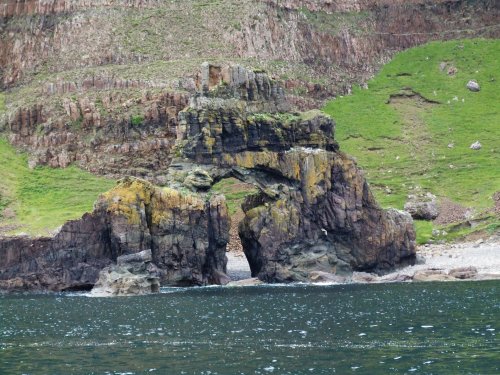
Carsaig Arches

Carsaig Arches are natural arch cliff formations on the Ross of Mull in the south of the Isle of Mull, on the west coast of Scotland. They are situated...

Pennyghael

Pennyghael (Scottish Gaelic: Peighinn nan Gàidheal) is a small village in the Ross of Mull, Argyll and Bute, Scotland. It is located along the A849 road...

Loch Buie

Loch Buie (Scottish Gaelic: Locha Buidhe, meaning "yellow loch") is a sea loch on the south coast of the Isle of Mull, off the west coast of Scotland....

Nearby Amenities

Located within 500m of 56.320281,-5.9795041
Created By: dmgroom_coastlines
Source: PGS
Lat/Long: 56.322184/-5.981416
Parking
Access: yes
Capacity: 4
Fee: no
Parking: surface
Lat/Long: 56.3207969/-5.9718418
Carsaig
Name En: Carsaig
Name Gd: Càrsaig
Place: hamlet
Lat/Long: 56.3246122/-5.9776288
Power: pole
Lat/Long: 56.3226614/-5.9766555
Power: pole
Lat/Long: 56.3229147/-5.9772098
Power: pole
Lat/Long: 56.3235196/-5.9775779
Power: pole
Lat/Long: 56.3236635/-5.9776888
Power: pole
Lat/Long: 56.3238664/-5.9784139
Power: pole
Lat/Long: 56.3240656/-5.9791058
Power: pole
Lat/Long: 56.3242832/-5.9798597
Power: pole
Lat/Long: 56.3246287/-5.9811192
The data included in this document is from www.openstreetmap.org. The data is made available under ODbL.

Have you been to Carsaig Bay?

Leave your review of Carsaig Bay below (or comments, questions and feedback).