Bay of Laig

Bay in Inverness-shire

Scotland

Bay of Laig

The Bay of Laig, Isle of Eigg Looking across the Sound of Rum to a splendid profile of that island.
The Bay of Laig, Isle of Eigg Credit: Michael Earnshaw

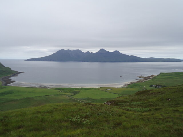
The Bay of Laig is a picturesque bay located in Inverness-shire, Scotland. It is situated on the western coast of the Isle of Eigg, one of the Small Isles in the Inner Hebrides. The bay is known for its stunning sandy beach, clear turquoise waters, and breathtaking views of the surrounding cliffs and mountains.

The Bay of Laig is a popular destination for visitors seeking a peaceful and scenic retreat. The beach is a great spot for sunbathing, picnicking, and swimming in the summer months. The bay is also a haven for wildlife, with seabirds, seals, and occasionally dolphins being spotted in the waters.

Visitors to the Bay of Laig can enjoy hiking along the coastal cliffs, exploring the nearby village of Cleadale, or simply relaxing and taking in the natural beauty of the area. The bay is accessible by boat or by a scenic walk from the ferry terminal at the northern end of the island.

Overall, the Bay of Laig is a hidden gem in the Scottish Highlands, offering visitors a tranquil and unspoiled coastal escape.

If you have any feedback on the listing, please let us know in the comments section below.

Bay of Laig Images

Images are sourced within 2km of 56.924334/-6.162541 or Grid Reference NM4689. Thanks to Geograph Open Source API. All images are credited.

The Bay of Laig, Isle of Eigg Looking across the Sound of Rum to a splendid profile of that island.
The Bay of Laig, Isle of Eigg
Looking across the Sound of Rum to a splendid profile of that island.
Rocky shore below Blar Mor Near the NW corner of Eigg, looking across to Rum.
Rocky shore below Blar Mor
Near the NW corner of Eigg, looking across to Rum.
Collapsed stile above Howlin A test for those with inside leg measurements on the short side.
Collapsed stile above Howlin
A test for those with inside leg measurements on the short side.
Leit an Aonaich A Gaelic name meaning something like the 'sloping side of the ridge' which well describes this very sharp prow looming above the pass to the north side of the island.
Leit an Aonaich
A Gaelic name meaning something like the 'sloping side of the ridge' which well describes this very sharp prow looming above the pass to the north side of the island.
The north side of Eigg The very steep slopes below Dunan Thalasgair seen from the pass of the Bealach Thuilm, with Skye in the background.
The north side of Eigg
The very steep slopes below Dunan Thalasgair seen from the pass of the Bealach Thuilm, with Skye in the background.
The north side of Eigg (2) Complex country with irregular terrain and large boulders at the foot of the steep slope below Dunan Thalasgair.
The north side of Eigg (2)
Complex country with irregular terrain and large boulders at the foot of the steep slope below Dunan Thalasgair.
The northwest corner of Eigg Rain on the way in this view from Guala  Mhor across to Rum.
The northwest corner of Eigg
Rain on the way in this view from Guala Mhor across to Rum.
Shore at Bogha na Brice-nis
Tràigh na Bìgil, Isle of Eigg
The west coast of Eigg by Cleadale A view from Blàr Mòr with horses on the hillside and the Bay of Laig and the Singing Sands beyond. The Sgurr of Eigg is seen over the Bay of Laig.
The west coast of Eigg by Cleadale
A view from Blàr Mòr with horses on the hillside and the Bay of Laig and the Singing Sands beyond. The Sgurr of Eigg is seen over the Bay of Laig.
Horses on Blàr Mòr, Isle of Eigg Behind the horses are the cliffs of Beinn Bhuidhe above Cleadale.
Horses on Blàr Mòr, Isle of Eigg
Behind the horses are the cliffs of Beinn Bhuidhe above Cleadale.
Hillside below Blàr Mòr
Cliffs below Blàr Mòr
Bogha na Brice nis
Bogha na Brice nis
Blar Mor
Blar Mor
Beinn Bhuidhe trig point Isle of Rum in the background
Beinn Bhuidhe trig point
Isle of Rum in the background
View of the bay from high on the hill
Beinn Bhuidhe A well defined footpath near Cleadale takes you to the summit for spectacular views of Rum and Eigg.
Beinn Bhuidhe
A well defined footpath near Cleadale takes you to the summit for spectacular views of Rum and Eigg.
Show me another place!

Bay of Laig is located at Grid Ref: NM4689 (Lat: 56.924334, Lng: -6.162541)

Unitary Authority: Highland

Police Authority: Highlands and Islands

What 3 Words

///softest.refer.clearly. Near Arisaig, Highland

Related Wikis

Cleadale

Cleadale (Scottish Gaelic: Clèadail) is a settlement on the north west side of the island of Eigg, in the Small Isles of Scotland and is in the council...

Eigg

Eigg ( eg; Scottish Gaelic: Eige; Scots: Eigg) is one of the Small Isles in the Scottish Inner Hebrides. It lies to the south of the Isle of Skye and to...

An Sgùrr (Eigg)

An Sgùrr is the highest hill on the Inner Hebridean island of Eigg, Lochaber, Highland, Scotland. It was formed 58.72 ± 0.07 million years ago; the result...

Galmisdale

Galmisdale is the main port of the island of Eigg, one of the Small Isles of the Inner Hebrides. It is in the Scottish council area of Highland. ��2�...

Nearby Amenities

Located within 500m of 56.924334,-6.162541
Source: PGS
Lat/Long: 56.9220311/-6.1576618
Source: PGS
Lat/Long: 56.9228351/-6.1580986
Source: PGS
Lat/Long: 56.9230811/-6.1582392
Source: PGS
Lat/Long: 56.9232998/-6.1584007
Source: PGS
Lat/Long: 56.9236694/-6.1588104
Source: PGS
Lat/Long: 56.9238357/-6.1590075
Source: PGS
Lat/Long: 56.9250235/-6.1605437
Source: PGS
Lat/Long: 56.925033/-6.1605161
Source: PGS
Lat/Long: 56.9250297/-6.1605934
Source: PGS
Lat/Long: 56.9250795/-6.1607098
Source: PGS
Lat/Long: 56.9251539/-6.1607959
Source: PGS
Lat/Long: 56.9255287/-6.1610128
Source: PGS
Lat/Long: 56.9256/-6.1610008
Source: PGS
Lat/Long: 56.9256689/-6.1609496
Source: PGS
Lat/Long: 56.9262221/-6.1605508
Source: PGS
Lat/Long: 56.9271347/-6.1599081
Source: PGS
Lat/Long: 56.9272014/-6.1598811
Source: PGS
Lat/Long: 56.9274253/-6.1596255
Source: PGS
Lat/Long: 56.9276098/-6.1592559
Source: PGS
Lat/Long: 56.9278292/-6.1588617
Source: PGS
Lat/Long: 56.9217077/-6.1576885
The data included in this document is from www.openstreetmap.org. The data is made available under ODbL.

Have you been to Bay of Laig?

Leave your review of Bay of Laig below (or comments, questions and feedback).