Am Bagh-dhùin

Bay in Inverness-shire

Scotland

Am Bagh-dhùin

Moorland near Drochaid an Lòin Ruaidh
Moorland near Drochaid an Lòin Ruaidh Credit: David Dixon

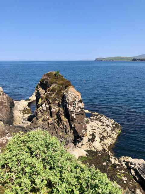
Am Bagh-dhùin, located in Inverness-shire, Scotland, is a picturesque bay known for its stunning natural beauty and tranquil atmosphere. The bay is nestled between rolling hills and cliffs, providing a breathtaking backdrop for visitors to enjoy.

The waters of Am Bagh-dhùin are crystal clear and shimmering, perfect for swimming, kayaking, and other water activities. The bay is also a popular spot for birdwatching, with a variety of seabirds and other wildlife calling the area home.

Surrounding the bay are lush green fields and forests, making it a peaceful retreat for those looking to escape the hustle and bustle of city life. The nearby village of Inverness-shire offers amenities such as restaurants, shops, and accommodations for visitors to enjoy.

Overall, Am Bagh-dhùin is a hidden gem in the Scottish Highlands, offering a serene and natural setting for outdoor enthusiasts and nature lovers alike. Whether you're looking to relax on the beach, explore the surrounding countryside, or simply take in the stunning views, Am Bagh-dhùin is sure to leave a lasting impression on all who visit.

If you have any feedback on the listing, please let us know in the comments section below.

Am Bagh-dhùin Images

Images are sourced within 2km of 57.530192/-6.3764925 or Grid Reference NG3857. Thanks to Geograph Open Source API. All images are credited.

Moorland near Drochaid an Lòin Ruaidh
River Hinnisdal Looking downstream from Hinnisdal Bridge on the A87.
River Hinnisdal
Looking downstream from Hinnisdal Bridge on the A87.
View towards Loch Snizort Beag
Hill above Loch Snizort
Moorland above Loch Snizort
A87 The A87 runs 99 miles from Invergarry to Uig on the Isle of Skye <a href="https://www.geograph.org.uk/photo/7374675">NG3863 : End of the A87, Uig</a>.
<span class="nowrap"><a title="https://www.sabre-roads.org.uk/wiki/index.php?title=A87" rel="nofollow ugc noopener" href="https://www.sabre-roads.org.uk/wiki/index.php?title=A87">Link</a><img style="margin-left:2px;" alt="External link" title="External link - shift click to open in new window" src="https://s1.geograph.org.uk/img/external.png" width="10" height="10"/></span>
A87
The A87 runs 99 miles from Invergarry to Uig on the Isle of Skye NG3863 : End of the A87, Uig. LinkExternal link
A87, southbound The A87 runs 99 miles from Invergarry to Uig on the Isle of Skye <a href="https://www.geograph.org.uk/photo/7374675">NG3863 : End of the A87, Uig</a>.
<span class="nowrap"><a title="https://www.sabre-roads.org.uk/wiki/index.php?title=A87" rel="nofollow ugc noopener" href="https://www.sabre-roads.org.uk/wiki/index.php?title=A87">Link</a><img style="margin-left:2px;" alt="External link" title="External link - shift click to open in new window" src="https://s1.geograph.org.uk/img/external.png" width="10" height="10"/></span>
A87, southbound
The A87 runs 99 miles from Invergarry to Uig on the Isle of Skye NG3863 : End of the A87, Uig. LinkExternal link
A87, approaching Hinnisdal Bridge The A87 runs 99 miles from Invergarry to Uig on the Isle of Skye <a href="https://www.geograph.org.uk/photo/7374675">NG3863 : End of the A87, Uig</a>.
<span class="nowrap"><a title="https://www.sabre-roads.org.uk/wiki/index.php?title=A87" rel="nofollow ugc noopener" href="https://www.sabre-roads.org.uk/wiki/index.php?title=A87">Link</a><img style="margin-left:2px;" alt="External link" title="External link - shift click to open in new window" src="https://s1.geograph.org.uk/img/external.png" width="10" height="10"/></span>
A87, approaching Hinnisdal Bridge
The A87 runs 99 miles from Invergarry to Uig on the Isle of Skye NG3863 : End of the A87, Uig. LinkExternal link
Tòrr na Bodhaig According to the Ordnance Surveyor's notes according to the 1881 Inverness-shire (Isle of Skye), Sheet XVI 6" map, <<this name applies to a prominent hill which signifies "Sea larks hill," >> — see ‘OS1/16/5/118 | ScotlandsPlaces’. 2019. Scotlandsplaces.gov.uk <<span class="nowrap"><a title="https://scotlandsplaces.gov.uk/digital-volumes/ordnance-survey-name-books/inverness-shire-os-name-books-1876-1878/inverness-shire-skye-volume-05/120" rel="nofollow ugc noopener" href="https://scotlandsplaces.gov.uk/digital-volumes/ordnance-survey-name-books/inverness-shire-os-name-books-1876-1878/inverness-shire-skye-volume-05/120">Link</a><img style="margin-left:2px;" alt="External link" title="External link - shift click to open in new window" src="https://s1.geograph.org.uk/img/external.png" width="10" height="10"/></span> > [accessed 21 July 2023]

This map shows no contours but does indicate a spot height of 163 feet see <span class="nowrap"><a title="https://maps.nls.uk/view/228778624#zoom=6&lat=8885&lon=11694&layers=BT" rel="nofollow ugc noopener" href="https://maps.nls.uk/view/228778624#zoom=6&lat=8885&lon=11694&layers=BT">Link</a><img style="margin-left:2px;" alt="External link" title="External link - shift click to open in new window" src="https://s1.geograph.org.uk/img/external.png" width="10" height="10"/></span>
Tòrr na Bodhaig
According to the Ordnance Surveyor's notes according to the 1881 Inverness-shire (Isle of Skye), Sheet XVI 6" map, <<this name applies to a prominent hill which signifies "Sea larks hill," >> — see ‘OS1/16/5/118 | ScotlandsPlaces’. 2019. Scotlandsplaces.gov.uk <LinkExternal link > [accessed 21 July 2023] This map shows no contours but does indicate a spot height of 163 feet see LinkExternal link
Basalt Dyke A basalt dyke stretching out towards Eilean Beag. The intrusion must be younger than the remainder of the rocks that comprise the rest of this coast.

On the Ordnance Survey 6&amp;quot; map Inverness-shire (Isle of Skye), Sheet X published 1881 (see &lt;span class=&quot;nowrap&quot;&gt;&lt;a title=&quot;https://maps.nls.uk/view/228778606#zoom=6&amp;amp;lat=1206&amp;amp;lon=11277&amp;amp;layers=BT&quot; rel=&quot;nofollow ugc noopener&quot; href=&quot;https://maps.nls.uk/view/228778606#zoom=6&amp;amp;lat=1206&amp;amp;lon=11277&amp;amp;layers=BT&quot;&gt;Link&lt;/a&gt;&lt;img style=&quot;margin-left:2px;&quot; alt=&quot;External link&quot; title=&quot;External link - shift click to open in new window&quot; src=&quot;https://s1.geograph.org.uk/img/external.png&quot; width=&quot;10&quot; height=&quot;10&quot;/&gt;&lt;/span&gt; ), the island is named as Eilean an Taomain which means the &amp;quot;Island of the water scoop&amp;quot; — see ‘OS1/16/5/71 | ScotlandsPlaces’. 2019. Scotlandsplaces.gov.uk &amp;lt;&lt;span class=&quot;nowrap&quot;&gt;&lt;a title=&quot;https://scotlandsplaces.gov.uk/digital-volumes/ordnance-survey-name-books/inverness-shire-os-name-books-1876-1878/inverness-shire-skye-volume-05/71&quot; rel=&quot;nofollow ugc noopener&quot; href=&quot;https://scotlandsplaces.gov.uk/digital-volumes/ordnance-survey-name-books/inverness-shire-os-name-books-1876-1878/inverness-shire-skye-volume-05/71&quot;&gt;Link&lt;/a&gt;&lt;img style=&quot;margin-left:2px;&quot; alt=&quot;External link&quot; title=&quot;External link - shift click to open in new window&quot; src=&quot;https://s1.geograph.org.uk/img/external.png&quot; width=&quot;10&quot; height=&quot;10&quot;/&gt;&lt;/span&gt; &amp;gt; [accessed 21 July 2023].
Basalt Dyke
A basalt dyke stretching out towards Eilean Beag. The intrusion must be younger than the remainder of the rocks that comprise the rest of this coast. On the Ordnance Survey 6" map Inverness-shire (Isle of Skye), Sheet X published 1881 (see LinkExternal link ), the island is named as Eilean an Taomain which means the "Island of the water scoop" — see ‘OS1/16/5/71 | ScotlandsPlaces’. 2019. Scotlandsplaces.gov.uk <LinkExternal link > [accessed 21 July 2023].
A deserted township reflected by the peculiar absence of bracken on the buildings' elevated walls For more info see ‘Skye, Lyndale Point | Canmore’. 2023. Canmore.org.uk &amp;lt;&lt;span class=&quot;nowrap&quot;&gt;&lt;a title=&quot;https://canmore.org.uk/site/114717/skye-lyndale-point&quot; rel=&quot;nofollow ugc noopener&quot; href=&quot;https://canmore.org.uk/site/114717/skye-lyndale-point&quot;&gt;Link&lt;/a&gt;&lt;img style=&quot;margin-left:2px;&quot; alt=&quot;External link&quot; title=&quot;External link - shift click to open in new window&quot; src=&quot;https://s1.geograph.org.uk/img/external.png&quot; width=&quot;10&quot; height=&quot;10&quot;/&gt;&lt;/span&gt; &amp;gt; [accessed 21 July 2023]
A deserted township reflected by the peculiar absence of bracken on the buildings' elevated walls
For more info see ‘Skye, Lyndale Point | Canmore’. 2023. Canmore.org.uk <LinkExternal link > [accessed 21 July 2023]
A carpet of cotton-grass unfurls like a magical welcome mat on this sun-kissed Scottish hillside
A buoy with a rebellious spirit, defying cartographic norms by claiming its territory just east of the northing Another photograph taken from the same spot in the same direction on the very edge of this grid square, just a foot or so east of the northing, which the buoy in the distance seems to me to have been conveniently placed on.
A buoy with a rebellious spirit, defying cartographic norms by claiming its territory just east of the northing
Another photograph taken from the same spot in the same direction on the very edge of this grid square, just a foot or so east of the northing, which the buoy in the distance seems to me to have been conveniently placed on.
A87 between Earlish and Kingsburgh The Cuillins with typical cloudcap in the distance.
A87 between Earlish and Kingsburgh
The Cuillins with typical cloudcap in the distance.
Rough grazing near Hinnisdal Bridge in Trotternish
A87 heading south towards Hinnisdal Bridge
Show me another place!

Am Bagh-dhùin is located at Grid Ref: NG3857 (Lat: 57.530192, Lng: -6.3764925)

Unitary Authority: Highland

Police Authority: Highlands and Islands

What 3 Words

///flames.positions.fluctuate. Near Uig, Highland

Nearby Locations

Am Bagh-dhùin

Related Wikis

Snizort

Snizort (Scottish Gaelic: Snìosort) is an area of the Isle of Skye comprising the head of Loch Snizort and the western coast of Trotternish up to Uig,...

Kingsburgh, Skye

Kingsburgh (Gaelic: Cinnseaborgh) is a scattered crofting township, overlooking Loch Snizort Beag on the Trotternish peninsula of the Isle of Skye in...

Peinlich

Peinlich (Scottish Gaelic: Peighinn an Lighiche) is a hamlet on the Isle of Skye in Scotland. Its main claim to fame is that its name is German for "embarrassing...

Suladale

Suladale or Suledale (Scottish Gaelic: Sùladal) is a small mixed crofting hamlet of fewer than a dozen houses, located near Edinbane, on the north of...

Have you been to Am Bagh-dhùin?

Leave your review of Am Bagh-dhùin below (or comments, questions and feedback).