Port na Luing

Bay in Argyllshire

Scotland

Port na Luing

Knockvologan Low winter sunshine on an outcrop of typical pink granite by the beach opposite the Isle of Erraid. <a href="https://www.geograph.org.uk/photo/2984029">NM3019 : Ross of Mull Granite</a> is a more detailed view of part of the same outcrop.
Knockvologan Credit: Anne Burgess

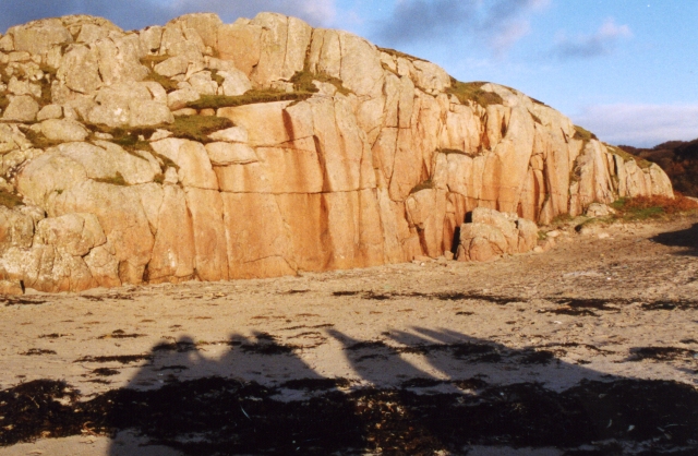
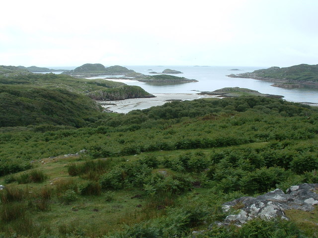
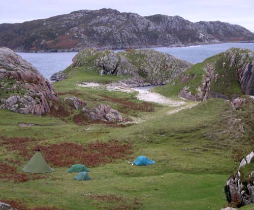
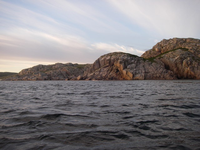
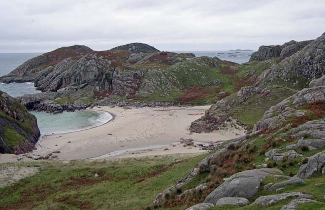
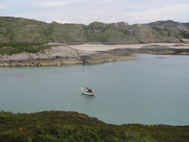
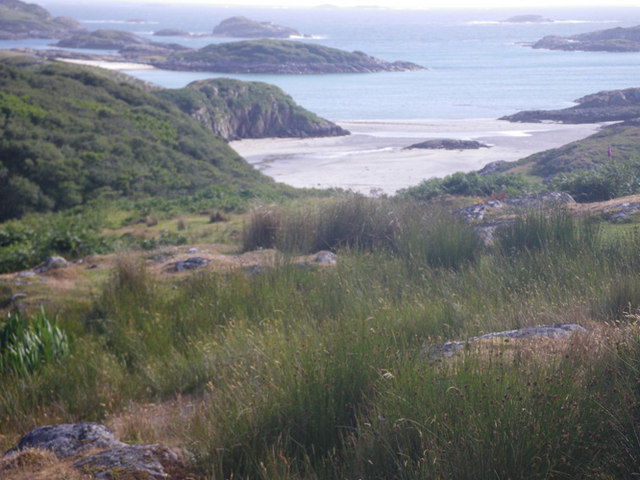
Port na Luing is a small bay located in Argyllshire, Scotland. Situated on the western coast of Scotland, this picturesque bay offers breathtaking views of the surrounding area. It is nestled between rugged cliffs and rolling hills, creating a stunning backdrop for visitors and locals alike.

The bay is known for its tranquil and secluded atmosphere, making it a popular destination for those seeking a peaceful getaway. The crystal-clear waters of the bay are ideal for swimming, snorkeling, and other water activities. Its calm nature also makes it an excellent spot for boating and fishing.

Port na Luing is home to a small fishing community that has thrived for generations. The bay's location provides an abundance of seafood, making it a hub for fresh and delicious catches. Visitors can enjoy local delicacies at the various seafood restaurants and cafes in the area.

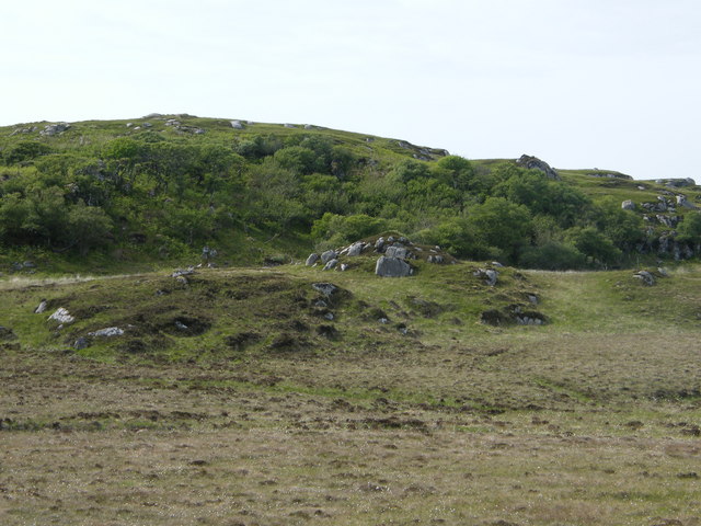
The bay is also surrounded by natural beauty, with stunning coastal walks and hiking trails available for outdoor enthusiasts. The nearby hills offer panoramic views of the bay and the surrounding landscapes. Wildlife enthusiasts will be delighted to spot various bird species, seals, and even dolphins that frequent the area.

Overall, Port na Luing is a hidden gem in Argyllshire, offering a serene and idyllic coastal experience. With its breathtaking scenery, rich marine life, and friendly community, it is a haven for nature lovers and those seeking a relaxing escape.

If you have any feedback on the listing, please let us know in the comments section below.

Port na Luing Images

Images are sourced within 2km of 56.279967/-6.3289885 or Grid Reference NM3218. Thanks to Geograph Open Source API. All images are credited.

Knockvologan Low winter sunshine on an outcrop of typical pink granite by the beach opposite the Isle of Erraid. <a href="https://www.geograph.org.uk/photo/2984029">NM3019 : Ross of Mull Granite</a> is a more detailed view of part of the same outcrop.
Knockvologan
Low winter sunshine on an outcrop of typical pink granite by the beach opposite the Isle of Erraid. NM3019 : Ross of Mull Granite is a more detailed view of part of the same outcrop.
View from hill at Knockvologan The foreground is Mull, the sea inlet off to the right is the channel between Mull and Erraid.
View from hill at Knockvologan
The foreground is Mull, the sea inlet off to the right is the channel between Mull and Erraid.
Retired hay baling machine In a typical farming way, the old baling machine/contraption at Knockvologan farm is left to age rather ungracefully. It is also used as a storage point for old and new fencing material.
Retired hay baling machine
In a typical farming way, the old baling machine/contraption at Knockvologan farm is left to age rather ungracefully. It is also used as a storage point for old and new fencing material.
Hunkered down on the Ross of Mull
Breac-achadh The settlement at Breac-achadh was deserted during the nineteenth century as a result of the Highland Clearances. Sheep farming was more profitable to the landlords than small collections of subsistence farmers ekeing a living on marginal land.
Breac-achadh
The settlement at Breac-achadh was deserted during the nineteenth century as a result of the Highland Clearances. Sheep farming was more profitable to the landlords than small collections of subsistence farmers ekeing a living on marginal land.
Traigh Gheal The path to the beach leads down through birch and scrub willow woodland.
Traigh Gheal
The path to the beach leads down through birch and scrub willow woodland.
Channel between Eilean Dubh and Ross of Mull
Ross of Mull - another perfect bay! There are countless bays like this along the Ross of Mull - havens for sea kayakers wanting to get away from it all.
Ross of Mull - another perfect bay!
There are countless bays like this along the Ross of Mull - havens for sea kayakers wanting to get away from it all.
Anchorage in Bagh a Chnoic Mhaoileanaich Taken from the slopes of Erraid looking east
Anchorage in Bagh a Chnoic Mhaoileanaich
Taken from the slopes of Erraid looking east
Slight detour required to navigate past boggy pond. Small pond fed by stream uphill to the left
Slight detour required to navigate past boggy pond.
Small pond fed by stream uphill to the left
Impressively weathered steps In the back-ground remnants of buildings, part of the Breac achadh settlement?
Impressively weathered steps
In the back-ground remnants of buildings, part of the Breac achadh settlement?
View of the four abandoned houses.
Small mound in front of  Torr Fada
Small mound in front of Torr Fada
Linne nan Ribheid Smallish pond at Linne nan Ribheid, looks like there's been a bit of a dry spell on Mull.
Linne nan Ribheid
Smallish pond at Linne nan Ribheid, looks like there's been a bit of a dry spell on Mull.
Rough grassland with sea cove in the distance
Rock outcrops Rock outcrops to the east of the beach are grey and rough when compared with the smooth, pink granite because they comprise thermally-metamorphosed Moine Schists adjacent to their contact with the granite intrusion, veins of which can be found working their way into this 'country' rock. A stand of iris is a characteristic margin to the neat turf developed on the sand above the high-tide mark.
Rock outcrops
Rock outcrops to the east of the beach are grey and rough when compared with the smooth, pink granite because they comprise thermally-metamorphosed Moine Schists adjacent to their contact with the granite intrusion, veins of which can be found working their way into this 'country' rock. A stand of iris is a characteristic margin to the neat turf developed on the sand above the high-tide mark.
Stranded seaweed Stranded seaweed at the high tide line fills the outfall of a small stream on the edge of Erraid Sound.
Stranded seaweed
Stranded seaweed at the high tide line fills the outfall of a small stream on the edge of Erraid Sound.
Granite intrusion Many places along this shore show the complex intrusion of the pink granite into the country rock, which is the metasedimentary Moine Schist, here demonstrating very fine layering. Whether the Moine Schist here is an enclave within the granite, or the granite is intruding into metasediments is open to debate. Either way, the margins of the Ross of Mull granite are a classic demonstration of 'forceful' intrusion.
Granite intrusion
Many places along this shore show the complex intrusion of the pink granite into the country rock, which is the metasedimentary Moine Schist, here demonstrating very fine layering. Whether the Moine Schist here is an enclave within the granite, or the granite is intruding into metasediments is open to debate. Either way, the margins of the Ross of Mull granite are a classic demonstration of 'forceful' intrusion.
Show me another place!

Port na Luing is located at Grid Ref: NM3218 (Lat: 56.279967, Lng: -6.3289885)

Unitary Authority: Argyll and Bute

Police Authority: Argyll and West Dunbartonshire

What 3 Words

///mural.fewer.helped. Near Fionnphort, Argyll & Bute

Related Wikis

Erraid

Erraid (Scottish Gaelic: Eilean Earraid) is a tidal island approximately one mile (two kilometres) square located in the Inner Hebrides of Scotland. It...

Ross of Mull

The Ross of Mull (Scottish Gaelic: An Ros Mhuileach) is the largest peninsula of the Isle of Mull, about 28 kilometres (17 mi) long, and makes up the south...

Aridhglas

Aridhglas is a village on the Ross of Mull, Isle of Mull in Argyll and Bute, Scotland. == References ==

Knocknafenaig

Knocknafenaig (Scottish Gaelic: Cnoc na Fennaig) is a ruined township on the Isle of Mull, Scotland. Located in the south-western portion of the island...

Nearby Amenities

Located within 500m of 56.279967,-6.3289885
Created By: dmgroom_coastlines
Source: PGS
Lat/Long: 56.27573/-6.32897
Created By: dmgroom_coastlines
Source: PGS
Lat/Long: 56.27575/-6.32989
Created By: dmgroom_coastlines
Source: PGS
Lat/Long: 56.27677/-6.33005
Created By: dmgroom_coastlines
Source: PGS
Lat/Long: 56.2773/-6.33047
Source: PGS
Lat/Long: 56.278733/-6.3308828
Source: PGS
Lat/Long: 56.2790707/-6.3301125
Created By: dmgroom_coastlines
Source: PGS
Lat/Long: 56.27919/-6.32919
Created By: dmgroom_coastlines
Source: PGS
Lat/Long: 56.27905/-6.32828
Created By: dmgroom_coastlines
Source: PGS
Lat/Long: 56.2793/-6.32803
Created By: dmgroom_coastlines
Source: PGS
Lat/Long: 56.27955/-6.32779
Created By: dmgroom_coastlines
Source: PGS
Lat/Long: 56.27957/-6.3287
Created By: dmgroom_coastlines
Source: PGS
Lat/Long: 56.27982/-6.32846
Created By: dmgroom_coastlines
Source: PGS
Lat/Long: 56.28033/-6.32842
Created By: dmgroom_coastlines
Source: PGS
Lat/Long: 56.28059/-6.32863
Created By: dmgroom_coastlines
Source: PGS
Lat/Long: 56.28057/-6.32771
Created By: dmgroom_coastlines
Source: PGS
Lat/Long: 56.28083/-6.32769
Created By: dmgroom_coastlines
Source: PGS
Lat/Long: 56.28085/-6.32861
Created By: dmgroom_coastlines
Source: PGS
Lat/Long: 56.28136/-6.32858
Created By: dmgroom_coastlines
Source: PGS
Lat/Long: 56.28143/-6.32673
Created By: dmgroom_coastlines
Source: PGS
Lat/Long: 56.28166/-6.32488
Created By: dmgroom_coastlines
Source: PGS
Lat/Long: 56.28191/-6.3244
Created By: dmgroom_coastlines
Source: PGS
Lat/Long: 56.28203/-6.32347
Source: PGS
Lat/Long: 56.2825366/-6.3231796
Source: PGS
Lat/Long: 56.2825464/-6.3243725
Source: PGS
Lat/Long: 56.2827279/-6.3249336
Source: PGS
Lat/Long: 56.2831644/-6.3260955
Source: PGS
Lat/Long: 56.2830393/-6.3271779
Source: PGS
Lat/Long: 56.2834416/-6.3295016
Source: PGS
Lat/Long: 56.283793/-6.3295285
The data included in this document is from www.openstreetmap.org. The data is made available under ODbL.

Have you been to Port na Luing?

Leave your review of Port na Luing below (or comments, questions and feedback).