Am Port Mòr

Bay in Ross-shire

Scotland

Am Port Mòr

Craft workshop in Kirkibost One of the old shellfish processing factories at Kirkibost (Circeabost) is now reborn as a craftshop.
Craft workshop in Kirkibost Credit: Gus Macdonald

Am Port Mòr, also known as the Bay of Am Port Mòr, is a scenic coastal area located in Ross-shire, Scotland. Situated on the northwestern coast of the country, this bay is a popular tourist destination known for its stunning natural beauty and rich history.

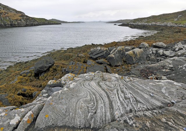
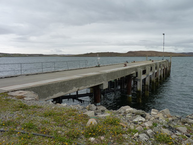
The Bay of Am Port Mòr is nestled between the villages of Mellon Charles and Aultbea, overlooking Loch Ewe. It features a sprawling sandy beach that stretches for approximately 2 miles, offering visitors a serene and picturesque setting to enjoy the Scottish coastline. The bay is surrounded by rolling hills and craggy cliffs, providing breathtaking views of the surrounding landscape.

In addition to its natural beauty, Am Port Mòr is also steeped in history. During World War II, the bay played a crucial role in the protection of Allied convoys. It served as a base for the Royal Navy and was heavily fortified with anti-aircraft guns and searchlights. The remnants of these defensive structures can still be seen today, adding an intriguing historical element to the area.

Visitors to Am Port Mòr can partake in a variety of activities, including beach walks, wildlife spotting, and birdwatching. The bay is home to a diverse range of bird species, making it a popular spot for ornithologists and nature enthusiasts. Additionally, the area offers ample opportunities for water sports such as kayaking, sailing, and fishing.

Overall, Am Port Mòr is a captivating destination that seamlessly combines natural beauty with historical significance, making it a must-visit location for those exploring the Ross-shire region of Scotland.

If you have any feedback on the listing, please let us know in the comments section below.

Am Port Mòr Images

Images are sourced within 2km of 58.206251/-6.7834359 or Grid Reference NB1934. Thanks to Geograph Open Source API. All images are credited.

Craft workshop in Kirkibost One of the old shellfish processing factories at Kirkibost (Circeabost) is now reborn as a craftshop.
Craft workshop in Kirkibost
One of the old shellfish processing factories at Kirkibost (Circeabost) is now reborn as a craftshop.
Cleibh ghiomaich aig cidhe Chirceabost Lobster creels at Kirkibost harbour
Cleibh ghiomaich aig cidhe Chirceabost
Lobster creels at Kirkibost harbour
Telephone Box at Crulabhig Probably it's only the sheep that get calls here?
Telephone Box at Crulabhig
Probably it's only the sheep that get calls here?
View towards Circebost Pier
Crulivig: the telephone box Pictured during heavy rain, this phone box has Hebridean doors, to keep the wind at bay.
Crulivig: the telephone box
Pictured during heavy rain, this phone box has Hebridean doors, to keep the wind at bay.
Crulivig: postbox № HS2 91 This postbox stands on the opposite side of the road to <a href="https://www.geograph.org.uk/photo/3286743">NB1733 : Crulivig: the telephone box</a>. It is emptied each morning except Sunday at a quarter to nine.
Crulivig: postbox № HS2 91
This postbox stands on the opposite side of the road to NB1733 : Crulivig: the telephone box. It is emptied each morning except Sunday at a quarter to nine.
Low cloud over Great Bernera A thin bank of cloud over the sea. Looking northeast from the B8059 near Lundale.
Low cloud over Great Bernera
A thin bank of cloud over the sea. Looking northeast from the B8059 near Lundale.
Rough pasture near Lundale Looking east towards Callanish, across Loch Ròg.
Rough pasture near Lundale
Looking east towards Callanish, across Loch Ròg.
Croftland, Circebost, Great Bernera Looking across Loch Ròg an Ear (East Loch Roag) towards Eilean Chearstaigh.
Croftland, Circebost, Great Bernera
Looking across Loch Ròg an Ear (East Loch Roag) towards Eilean Chearstaigh.
Calanais/Callanish XV, Circebost, Great Bernera/Beàrnaraigh From Discovery and Excavation in Scotland, 1976: "On grassy ridge 100m N of road, 25m E of track through Croft 24, Kirkibost. A large prone slab approx. 3.55m x 1.35m, thickness varying from 0.25-0.45m, lying in peat on a grassy ridge. The lower end appears to be surrounded by packing stones and there is a void under the centre of the stone. This stone was brought to our notice by Mr Norman MacDonald of Kirkibost."
Calanais/Callanish XV, Circebost, Great Bernera/Beàrnaraigh
From Discovery and Excavation in Scotland, 1976: "On grassy ridge 100m N of road, 25m E of track through Croft 24, Kirkibost. A large prone slab approx. 3.55m x 1.35m, thickness varying from 0.25-0.45m, lying in peat on a grassy ridge. The lower end appears to be surrounded by packing stones and there is a void under the centre of the stone. This stone was brought to our notice by Mr Norman MacDonald of Kirkibost."
Possible fallen standing stone, Circebost, Great Bernera/Beàrnaraigh This stone lies approximately 80m ESE of <a href="https://www.geograph.org.uk/photo/5293759">NB1734 : Calanais/Callanish XV, Circebost, Great Bernera/Beàrnaraigh</a>.  The croft owner, who is the grandson of Norman MacDonald who originally brought Callanish XV to archaeologists' attention, believes it to be fallen standing stone.
Possible fallen standing stone, Circebost, Great Bernera/Beàrnaraigh
This stone lies approximately 80m ESE of NB1734 : Calanais/Callanish XV, Circebost, Great Bernera/Beàrnaraigh. The croft owner, who is the grandson of Norman MacDonald who originally brought Callanish XV to archaeologists' attention, believes it to be fallen standing stone.
Looking down at Circebost Circebost or Kirkibost is a tiny settlement on Great Bernera. This island is now connected to Lewis by a short pre-stressed concrete bridge. In 1953 when it was built it was and remains the first bridge of such material in Europe.  

The settlemenr is also important as it is the first planned crofting township in the Outer Hebrides, though I think town is a lofty description for such a small group of houses.
Looking down at Circebost
Circebost or Kirkibost is a tiny settlement on Great Bernera. This island is now connected to Lewis by a short pre-stressed concrete bridge. In 1953 when it was built it was and remains the first bridge of such material in Europe. The settlemenr is also important as it is the first planned crofting township in the Outer Hebrides, though I think town is a lofty description for such a small group of houses.
Tòb Lundale, Isle of Lewis Tòb Lundale is an inlet on Loch Ròg.  Tòb is a Gaelic word for bay or cove.
Tòb Lundale, Isle of Lewis
Tòb Lundale is an inlet on Loch Ròg. Tòb is a Gaelic word for bay or cove.
Rubha Arspaig The pier at Rubha Arspaig.
Rubha Arspaig
The pier at Rubha Arspaig.
Pharmaceutical factory A surprisingly large industrial investment in an otherwise rural coastal area of Lewis, this plant, employing around 50 people, became part of BASF Pharma in March 2012 when the German company took over Equateq Ltd who had opened the plant in 2005 and operated it until then. It manufactures omega-3 fatty acids at exceptional purity levels for use in pharmaceuticals.
Pharmaceutical factory
A surprisingly large industrial investment in an otherwise rural coastal area of Lewis, this plant, employing around 50 people, became part of BASF Pharma in March 2012 when the German company took over Equateq Ltd who had opened the plant in 2005 and operated it until then. It manufactures omega-3 fatty acids at exceptional purity levels for use in pharmaceuticals.
Phonebox on the road to Great Bernera
Ruined cottage on Great Bernera The ruin stands at the side of the minor road close to the north shore of Loch Barraglom.
Ruined cottage on Great Bernera
The ruin stands at the side of the minor road close to the north shore of Loch Barraglom.
End of the road at Tobhtaral Two houses at the end of the road in the SE corner of Great Bernera island.
End of the road at Tobhtaral
Two houses at the end of the road in the SE corner of Great Bernera island.
Show me another place!

Am Port Mòr is located at Grid Ref: NB1934 (Lat: 58.206251, Lng: -6.7834359)

Unitary Authority: Na h-Eileanan an Iar

Police Authority: Highlands and Islands

What 3 Words

///smug.passport.superhero. Near Carloway, Na h-Eileanan Siar

Related Wikis

Ceabhaigh

Ceabhaigh is a small island in an arm of Loch Ròg on the west coast of Lewis in the Outer Hebrides of Scotland. It is about 25 hectares (62 acres) in extent...

Eilean Chearstaidh

Eilean Kearstay (Scottish Gaelic: Eilean Chearstaigh) is an uninhabited island in Loch Roag in the Outer Hebrides of Scotland. It lies south east of Great...

Callanish

Callanish (Scottish Gaelic: Calanais) is a village (township) on the west side of the Isle of Lewis, in the Outer Hebrides (Western Isles), Scotland. Callanish...

Callanish Stones

The Callanish Stones (or "Callanish I": Scottish Gaelic: Clachan Chalanais or Tursachan Chalanais) are an arrangement of standing stones placed in a cruciform...

Nearby Amenities

Located within 500m of 58.206251,-6.7834359
Turning Circle
Lat/Long: 58.2045075/-6.7848313
Barrier: cattle_grid
Source: Bing
Lat/Long: 58.2074391/-6.7873601
Barrier: cattle_grid
Source: Bing
Lat/Long: 58.207499/-6.7871423
Tobhtaral
Place: hamlet
Lat/Long: 58.2050209/-6.7845949
Power: pole
Lat/Long: 58.2044247/-6.7852007
Power: pole
Lat/Long: 58.2049266/-6.7854083
Power: pole
Lat/Long: 58.2054267/-6.7856318
Power: pole
Lat/Long: 58.205982/-6.7858518
Power: pole
Lat/Long: 58.2063055/-6.7859681
Power: pole
Lat/Long: 58.2065296/-6.7869533
Power: pole
Lat/Long: 58.2058203/-6.7861836
Power: pole
Lat/Long: 58.2072752/-6.7877613
Power: pole
Lat/Long: 58.207796/-6.7883422
Power: pole
Lat/Long: 58.2083981/-6.7890094
Power: pole
Lat/Long: 58.2091336/-6.7898126
Am Port Mor
Natural: bay
Lat/Long: 58.2084404/-6.7854228
The data included in this document is from www.openstreetmap.org. The data is made available under ODbL.

Have you been to Am Port Mòr?

Leave your review of Am Port Mòr below (or comments, questions and feedback).