Black Linn

Waterfall in Northumberland

England

Black Linn

View towards Bell Hill Downstream on the Coquet from Carshope.
View towards Bell Hill Credit: Trevor Harris

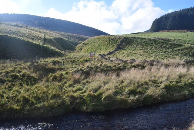
Black Linn is a picturesque waterfall located in the county of Northumberland, England. Nestled within the beautiful countryside, it is situated near the village of Bellingham, within the North Pennines Area of Outstanding Natural Beauty.

The waterfall itself is a striking feature, cascading down a series of rocky ledges, creating a dramatic display of rushing water. It is fed by the River North Tyne, which flows through the region. The falls are surrounded by lush greenery and towering trees, adding to the natural beauty of the area.

Visitors to Black Linn can enjoy a peaceful and tranquil setting, ideal for immersing oneself in nature. There are several walking trails in the vicinity, providing opportunities to explore the surrounding woodlands and enjoy scenic views. Birdwatchers may also be delighted to spot various species of birds that inhabit the area.

The waterfall is easily accessible and has become a popular destination for both locals and tourists. It offers a refreshing break from the hustle and bustle of everyday life, providing a serene and calming atmosphere. The sound of rushing water and the sight of the falls can create a meditative experience, making it a favorite spot for those seeking relaxation and rejuvenation.

Overall, Black Linn in Northumberland is a charming waterfall that showcases the natural beauty of the region. With its tranquil ambiance and stunning scenery, it is a must-visit destination for nature enthusiasts and anyone looking to appreciate the wonders of the great outdoors.

If you have any feedback on the listing, please let us know in the comments section below.

Black Linn Images

Images are sourced within 2km of 55.376485/-2.2478022 or Grid Reference NT8409. Thanks to Geograph Open Source API. All images are credited.

View towards Bell Hill Downstream on the Coquet from Carshope.
View towards Bell Hill
Downstream on the Coquet from Carshope.
Part of Upper Coquetdale On the dead-end road out of Alwinton.
Part of Upper Coquetdale
On the dead-end road out of Alwinton.
Dumbhope Burn View looking up Dumbhope Burn in Upper Coquetdale.
Dumbhope Burn
View looking up Dumbhope Burn in Upper Coquetdale.
Looking across the course of a northern tributary of the Ridlees Burn
Dumbhope Burn looking downstream Not clear from the photo is the swathe of stream-side grass flattened by the last flood which indicated a 'monsoon' water level.
Dumbhope Burn looking downstream
Not clear from the photo is the swathe of stream-side grass flattened by the last flood which indicated a 'monsoon' water level.
Byegate Hall Something Heathcliffey about this place - still very imposing and in good condition within as well as without amongst a dereliction of other remains.
Byegate Hall
Something Heathcliffey about this place - still very imposing and in good condition within as well as without amongst a dereliction of other remains.
Wild nameless ground between Hog Knowe and Fallow Knowes plantation Hidden amongst the grasses were mortar shell-holes making walking even harder than the tufty vegetation. Recent holes were water sumps and offered a quick if peaty bathe - or drowning.
Wild nameless ground between Hog Knowe and Fallow Knowes plantation
Hidden amongst the grasses were mortar shell-holes making walking even harder than the tufty vegetation. Recent holes were water sumps and offered a quick if peaty bathe - or drowning.
Mixed plantation on Hog Knowe of Deerbush Hill The largest tree in mid-photo caught my eye from miles away as a lone Scots Pine but it turned out a disappointing plane tree.
Mixed plantation on Hog Knowe of Deerbush Hill
The largest tree in mid-photo caught my eye from miles away as a lone Scots Pine but it turned out a disappointing plane tree.
Barrow on Black Knowe Sitting like an island in the wet boggy ground just south-south-east of Black Knowe I think this is a kaim. The photo was taken from a more complicated mound similarly dry and sandy on wet ground.
Barrow on Black Knowe
Sitting like an island in the wet boggy ground just south-south-east of Black Knowe I think this is a kaim. The photo was taken from a more complicated mound similarly dry and sandy on wet ground.
Fence junction on small top north of Black Knowe Ravens Cleugh in the back-drop.
Fence junction on small top north of Black Knowe
Ravens Cleugh in the back-drop.
Sheep-handling facility on west-south-west ridge of Bell Hill
Looking south down course of tributary of Deerbush Burn Byegate Hall and its high pasture fields in the background.
Looking south down course of tributary of Deerbush Burn
Byegate Hall and its high pasture fields in the background.
Ford on Dumbhope Burn More like a coalescence of burn and track!
Ford on Dumbhope Burn
More like a coalescence of burn and track!
Tributary of Dumbhope Burn below Brock's Holes
Dumbhope Burn west of tributary confluence
South-east aspect of Bell Hill below Brock's Holes
Looking west towards confluence of Deerbush Burn and Dumbhope Burn
Slopes of Dumb Hope
Slopes of Dumb Hope
Show me another place!

Black Linn is located at Grid Ref: NT8409 (Lat: 55.376485, Lng: -2.2478022)

Unitary Authority: Northumberland

Police Authority: Northumbria

What 3 Words

///dispensed.clings.song. Near Rochester, Northumberland

Nearby Locations

Black Linn

Related Wikis

Barrow Burn

Barrowburn is a hamlet in Upper Coquetdale in the county of Northumberland, England. It comprises a working farm with associated buildings and two holiday...

Barrow Burn Meadows

Barrow Burn Meadows is a Site of Special Scientific Interest (SSSI) in north Northumberland, England. The site is a species-rich hay meadow of a sort now...

Shillhope Law

Shillhope Law is a hill in the southern Cheviots, a range of hills in Northumberland, England. Shillhope Law is a relatively unremarkable member of this...

Featherwood Roman Camps

Featherwood Roman Camps are neighbouring archaeological sites in Northumberland, England, 1 mile (1.6 km) north of Featherwood and about 3 miles (5 km...

Have you been to Black Linn?

Leave your review of Black Linn below (or comments, questions and feedback).