Bawden Rocks

Island in Cornwall

England

Bawden Rocks

Crams Rocks - St Agnes Head These rocks straggle out seaward from St Agnes Head on the north Cornish coast. On the map the area around them is marked as "Crams" but the writing is in blue, suggesting that this is a water rather than a land feature. Nevertheless these rocks are in the area called Crams.
Crams Rocks - St Agnes Head Credit: Rob Farrow

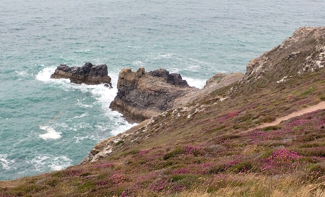
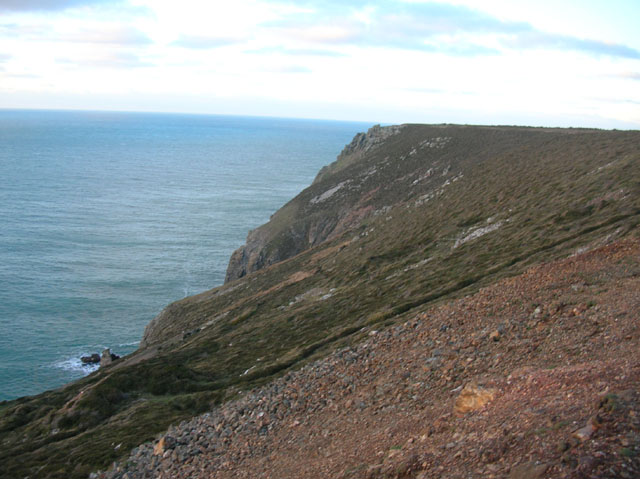
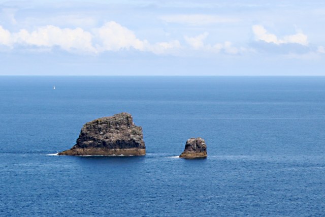
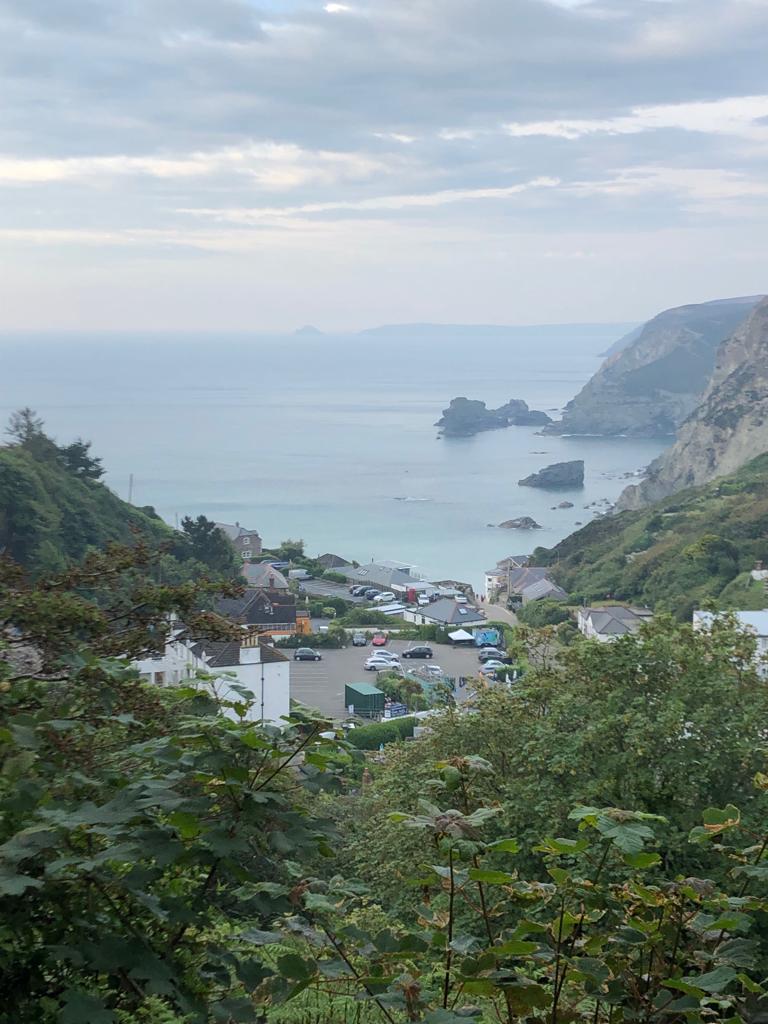
Bawden Rocks is a small uninhabited island located off the coast of Cornwall in the United Kingdom. The island is known for its rugged and rocky terrain, with steep cliffs and jagged rocks jutting out of the sea. Bawden Rocks is a popular spot for birdwatchers, as it is home to a variety of seabirds including puffins, guillemots, and razorbills.

The island is only accessible by boat and is not suitable for landing due to the treacherous conditions of the surrounding waters. The rocky shores of Bawden Rocks are often battered by strong currents and waves, making it a dangerous area for inexperienced sailors.

Despite its remote location and challenging conditions, Bawden Rocks is a popular destination for wildlife enthusiasts and photographers looking to capture the beauty of the rugged coastline and the diverse bird population that calls the island home. Visitors to Bawden Rocks are advised to exercise caution and respect the natural environment to ensure the preservation of this unique and precious habitat.

If you have any feedback on the listing, please let us know in the comments section below.

Bawden Rocks Images

Images are sourced within 2km of 50.334016/-5.2326988 or Grid Reference SW7053. Thanks to Geograph Open Source API. All images are credited.

Crams Rocks - St Agnes Head These rocks straggle out seaward from St Agnes Head on the north Cornish coast. On the map the area around them is marked as "Crams" but the writing is in blue, suggesting that this is a water rather than a land feature. Nevertheless these rocks are in the area called Crams.
Crams Rocks - St Agnes Head
These rocks straggle out seaward from St Agnes Head on the north Cornish coast. On the map the area around them is marked as "Crams" but the writing is in blue, suggesting that this is a water rather than a land feature. Nevertheless these rocks are in the area called Crams.
National Coastwatch St Agnes Head Precisely what it says on the label! This little square former Coastguard lookout is now run by the voluntary National Coastwatch Institution <span class="nowrap"><a title="https://www.nci.org.uk" rel="nofollow ugc noopener" href="https://www.nci.org.uk">Link</a><img style="margin-left:2px;" alt="External link" title="External link - shift click to open in new window" src="https://s1.geograph.org.uk/img/external.png" width="10" height="10"/></span> and is located high up on St Agnes Head with good views seaward.
National Coastwatch St Agnes Head
Precisely what it says on the label! This little square former Coastguard lookout is now run by the voluntary National Coastwatch Institution LinkExternal link and is located high up on St Agnes Head with good views seaward.
Coast path leading N to St Agnes Head
Cliffs, Carn Gowla Beautiful cliff scenery at Carn Gowla.
Cliffs, Carn Gowla
Beautiful cliff scenery at Carn Gowla.
From St Agnes Head towards Bawden Rocks There is a pair of significant offshore rocks here, Bawden Rocks or Man and his Man.  The view is from the Coastwatch station, a volunteer service keeping an eye on the coast from this extensive vantage point.
From St Agnes Head towards Bawden Rocks
There is a pair of significant offshore rocks here, Bawden Rocks or Man and his Man. The view is from the Coastwatch station, a volunteer service keeping an eye on the coast from this extensive vantage point.
Coastal path above near St Agnes Head St Agnes Head is seen from the coastal path above a steepening cliff.
Coastal path above near St Agnes Head
St Agnes Head is seen from the coastal path above a steepening cliff.
Crams rocks A distinctive promontory of rocks at St Agnes Head. There's even a path down to them, and everything, but I wasn't allowed to take Daft Dog down there...
Crams rocks
A distinctive promontory of rocks at St Agnes Head. There's even a path down to them, and everything, but I wasn't allowed to take Daft Dog down there...
Cliffs west of St Agnes Head
The SW Coast Path along St Agnes Head This section would make a superb MTB ride, were it legitimate. Crams rocks in the bottom left mark the NW limit of St Agnes Head.
The SW Coast Path along St Agnes Head
This section would make a superb MTB ride, were it legitimate. Crams rocks in the bottom left mark the NW limit of St Agnes Head.
Crams, St. Agnes Head Two island rocks and a headland, the larger island mostly hidden behind the headland.
Crams, St. Agnes Head
Two island rocks and a headland, the larger island mostly hidden behind the headland.
Lookout station, St. Agnes Head Operated by the National Coastwatch Institution.  For full details of this station, have a look at <span class="nowrap"><a title="http://www.nci.org.uk/stagneshead" rel="nofollow ugc noopener" href="http://www.nci.org.uk/stagneshead">Link</a><img style="margin-left:2px;" alt="External link" title="External link - shift click to open in new window" src="https://s1.geograph.org.uk/img/external.png" width="10" height="10"/></span> .
Lookout station, St. Agnes Head
Operated by the National Coastwatch Institution. For full details of this station, have a look at LinkExternal link .
Look Out Station, St Agnes Head
St.Agnes Head The rocks at the top of the cliff almost in the background of the picture are where the headland is.
St.Agnes Head
The rocks at the top of the cliff almost in the background of the picture are where the headland is.
St Agnes Head Waymark on the coast path, St Agnes Head.
St Agnes Head
Waymark on the coast path, St Agnes Head.
Sea Thrift at St Agnes Head In late spring some places on the Cornish coast turn pink with flowering sea thrift - <span class="nowrap"><a title="http://en.wikipedia.org/wiki/Armeria_maritima" rel="nofollow ugc noopener" href="http://en.wikipedia.org/wiki/Armeria_maritima">Link</a><img style="margin-left:2px;" alt="External link" title="External link - shift click to open in new window" src="https://s1.geograph.org.uk/img/external.png" width="10" height="10"/></span>.
Sea Thrift at St Agnes Head
In late spring some places on the Cornish coast turn pink with flowering sea thrift - LinkExternal link.
St Agnes Head Bawden rocks can be seen in the distance.
St Agnes Head
Bawden rocks can be seen in the distance.
St Agnes Head coastguard station Operated by the charity, The National Coastwatch Institution.
St Agnes Head coastguard station
Operated by the charity, The National Coastwatch Institution.
Rocks below St Agnes Head
Show me another place!

Bawden Rocks is located at Grid Ref: SW7053 (Lat: 50.334016, Lng: -5.2326988)

Unitary Authority: Cornwall

Police Authority: Devon and Cornwall

Also known as: Man and his Man

What 3 Words

///toned.sirens.interpreter. Near St Agnes, Cornwall

Related Wikis

Bawden Rocks

Bawden Rocks (Cornish: Meyn Bodyn), also known as Cow and Calf or Man and His Man, are a pair of small islands approximately one mile north of St Agnes...

Trevaunance Cove

Trevaunance Cove is a small bay on the north Cornish coast and a residential area of St Agnes, Cornwall, England, United Kingdom. In the 18th and 19th...

Higher Bal

Higher Bal is a hamlet in the parish of St Agnes, Cornwall, England. == References ==

St Agnes Lifeboat Station

St Agnes Lifeboat Station was opened in 1968 and is based in St Agnes, Cornwall, South West England. It is operated by the Royal National Lifeboat Institution...

Have you been to Bawden Rocks?

Leave your review of Bawden Rocks below (or comments, questions and feedback).