Burn Carrs

Island in Northumberland

England

Burn Carrs

Beadnell Harbour and 18th Century Lime Kilns The Lime Kilns are in the care of the National Trust
Beadnell Harbour and 18th Century Lime Kilns Credit: Bob Embleton

Burn Carrs is a small island located off the coast of Northumberland, England. It is situated in the North Sea, approximately 3 miles northeast of the town of Amble. The island covers an area of around 20 acres and is known for its scenic beauty and diverse wildlife.

The landscape of Burn Carrs consists of rolling hills covered in lush grass and heather, with some areas of dense woodland. The island is home to a variety of bird species, including puffins, gannets, and kittiwakes, making it a popular destination for birdwatchers.

The island is privately owned and is not open to the public. However, there are occasional guided tours arranged by local conservation organizations, allowing visitors to explore the island's natural wonders. These tours provide an opportunity to learn about the island's history and conservation efforts.

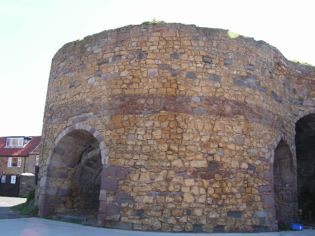
In addition to its natural beauty, Burn Carrs has historical significance. It was once used as a landing place for smugglers during the 18th and 19th centuries. The remnants of old stone structures and hidden caves can still be found on the island, serving as a reminder of its intriguing past.

Overall, Burn Carrs offers a peaceful and secluded retreat for nature enthusiasts and history buffs alike. Its stunning landscapes, abundant wildlife, and historical remnants make it a hidden gem in Northumberland's coastal region.

If you have any feedback on the listing, please let us know in the comments section below.

Burn Carrs Images

Images are sourced within 2km of 55.544308/-1.6277306 or Grid Reference NU2327. Thanks to Geograph Open Source API. All images are credited.

Beadnell Harbour and 18th Century Lime Kilns The Lime Kilns are in the care of the National Trust
Beadnell Harbour and 18th Century Lime Kilns
The Lime Kilns are in the care of the National Trust
Beadnell Harbour limekilns Beadnell Harbour after the restoration of 2000/2001, a local initiative. A prominent feature is that of the remains of Beadnell's lime kilns. The earliest dates from 1789.
Beadnell Harbour limekilns
Beadnell Harbour after the restoration of 2000/2001, a local initiative. A prominent feature is that of the remains of Beadnell's lime kilns. The earliest dates from 1789.
Tern Colony, Beadnell Sand Dunes Beadnell Bay, a sandy beach stretching 3 km (1.8 miles) to the south of the village of Beadnell, contains a nationally-important colony of Little Tern and the largest mainland colony of Arctic Tern in the United Kingdom. The beach was awarded the Blue Flag rural beach award in 2005.
The beach is backed by a series of sand dunes.
Tern Colony, Beadnell Sand Dunes
Beadnell Bay, a sandy beach stretching 3 km (1.8 miles) to the south of the village of Beadnell, contains a nationally-important colony of Little Tern and the largest mainland colony of Arctic Tern in the United Kingdom. The beach was awarded the Blue Flag rural beach award in 2005. The beach is backed by a series of sand dunes.
Sea front
Sea front
Beadnell Bay Beach Beadnell Bay, a sandy beach stretching 3 km (1.8 miles) to the south of the village of Beadnell, contains a nationally-important colony of Little Tern and the largest mainland colony of Arctic Tern in the United Kingdom. The beach was awarded the Blue Flag rural beach award in 2005.
The beach is backed by a series of sand dunes.
Beadnell Bay Beach
Beadnell Bay, a sandy beach stretching 3 km (1.8 miles) to the south of the village of Beadnell, contains a nationally-important colony of Little Tern and the largest mainland colony of Arctic Tern in the United Kingdom. The beach was awarded the Blue Flag rural beach award in 2005. The beach is backed by a series of sand dunes.
Embryo Dunes, Beadnell dunes Part of the extensive dune network on the NE coastline
Embryo Dunes, Beadnell dunes
Part of the extensive dune network on the NE coastline
Beadnell Dunes Beadnell Bay, a sandy beach stretching 3 km (1.8 miles) to the south of the village of Beadnell, contains a nationally-important colony of Little Tern and the largest mainland colony of Arctic Tern in the United Kingdom. The beach was awarded the Blue Flag rural beach award in 2005.
The beach is backed by a series of sand dunes.
Beadnell Dunes
Beadnell Bay, a sandy beach stretching 3 km (1.8 miles) to the south of the village of Beadnell, contains a nationally-important colony of Little Tern and the largest mainland colony of Arctic Tern in the United Kingdom. The beach was awarded the Blue Flag rural beach award in 2005. The beach is backed by a series of sand dunes.
Southern half of Beadnell Bay This huge bay takes up nearly three grid squares. Dunstanborough Castle can just be made out on the horizon
Southern half of Beadnell Bay
This huge bay takes up nearly three grid squares. Dunstanborough Castle can just be made out on the horizon
Runners on Beadnell beach On holiday and didn't fancy joining the race so I took a photo instead !
Runners on Beadnell beach
On holiday and didn't fancy joining the race so I took a photo instead !
Evening Sunshine at Beadnell Bay The sun finally broke through after a day of mist and drizzle.
Evening Sunshine at Beadnell Bay
The sun finally broke through after a day of mist and drizzle.
Lime kiln, Beadnell Bay Grade II listed. <span class="nowrap"><a title="http://www.britishlistedbuildings.co.uk/en-408483-lime-kilns-to-east-of-harbour-beadnell" rel="nofollow ugc noopener" href="http://www.britishlistedbuildings.co.uk/en-408483-lime-kilns-to-east-of-harbour-beadnell">Link</a><img style="margin-left:2px;" alt="External link" title="External link - shift click to open in new window" src="https://s1.geograph.org.uk/img/external.png" width="10" height="10"/></span>
Lime kiln, Beadnell Bay
Grade II listed. LinkExternal link
Beadnell House Hotel In the centre of Beadnell
Beadnell House Hotel
In the centre of Beadnell
Newton Links sand Dunes Part of an extensive dune complex owned by the National Trust.
Newton Links sand Dunes
Part of an extensive dune complex owned by the National Trust.
Young cattle and their mothers
Brunton Burn Brunton Burn is a small stream in Northumberland. It rises near the A1 on Middle Moor and flows east then north east approximately 12Km to Beadnell Bay. It joins with Long Nanny just before entering the sea.
Brunton Burn
Brunton Burn is a small stream in Northumberland. It rises near the A1 on Middle Moor and flows east then north east approximately 12Km to Beadnell Bay. It joins with Long Nanny just before entering the sea.
Sheep & Lambs
Sheep & Lambs
Wheat field & woodland
Sheep in a field
Sheep in a field
Show me another place!

Burn Carrs is located at Grid Ref: NU2327 (Lat: 55.544308, Lng: -1.6277306)

Unitary Authority: Northumberland

Police Authority: Northumbria

What 3 Words

///went.same.towel. Near Beadnell, Northumberland

Related Wikis

Benthall, Northumberland

Benthall is a village in Northumberland, England. It is about 6 kilometres (4 mi) south east of Bamburgh, on the North Sea coast, and 1 kilometre (⅔ mi...

Beadnell

Beadnell is a village and civil parish in Northumberland, England. It is situated about 4 miles (6.4 km) south-east of Bamburgh, on the North Sea coast...

Newton-by-the-Sea

Newton-by-the-Sea is a civil parish in the county of Northumberland in Northern England. The parish is about 8 miles northwest of Alnwick, and lies on...

RAF Brunton

Royal Air Force Brunton or more simply RAF Brunton is a former Royal Air Force satellite airfield located in Northumberland, England. The following units...

West Fleetham

West Fleetham is a small hamlet in Northumberland, England situated about 4 miles from Seahouses and 2 miles from Chathill railway station. It originally...

North Sunderland

North Sunderland is a fishing village on the coast of Northumberland, England, and adjacent to Seahouses. The population of the civil parish was 1,803...

Seahouses railway station

Seahouses railway station was the brick and wood built eastern terminus of the single track branch of the North Sunderland Railway, in north east England...

North Sunderland railway station

North Sunderland railway station was a brick built station on the single track branch of the North Sunderland Railway, in north east England. The line...

Related Videos

Belford to Fenwick, Northumberland Coast Path – Stage 5.

Walking the magnificent Northumberland Coast Path from Cresswell to Berwick-upon-Tweed. This is episode 5 of 6. Produced in ...

Beadnell, Bamburgh & Beaches Bank Holiday - Our Motorhome Travels

A bank holiday weekend in Northumberland staying at Beadnell Bay Camping & Caravan Club. Many delays heading north up ...

Beadnell - May Bank Holiday stroll in this popular seaside destination

Inspired by the beautiful sunshine albeit combined with a bitterly cold North wind, follow me as I stroll down to the Harbour and ...

Nearby Amenities

Located within 500m of 55.544308,-1.6277306
Burn Carrs
Place: locality
Lat/Long: 55.5457604/-1.6287378
The data included in this document is from www.openstreetmap.org. The data is made available under ODbL.

Have you been to Burn Carrs?

Leave your review of Burn Carrs below (or comments, questions and feedback).