Big Scarcar

Island in Northumberland

England

Big Scarcar

Inner Farne, West Wideopen and East Wideopen, The Farne Islands A group of 15 - 20 islands (depending on the tides) offshore of Seahouses, Northumberland. They are the most easterly outcrops of the Whin Sill (a dolerite intrusion across north east England). The islands are divided into the inner and outer islands. The Islands are an important breeding ground for many seabirds having a large Puffin population. There is also an important seal colony here. The whole area is designated a National Nature Reserve.
Wikipedia: <span class="nowrap"><a title="http://en.wikipedia.org/wiki/Farne_Islands" rel="nofollow ugc noopener" href="http://en.wikipedia.org/wiki/Farne_Islands">Link</a><img style="margin-left:2px;" alt="External link" title="External link - shift click to open in new window" src="https://s1.geograph.org.uk/img/external.png" width="10" height="10"/></span>
Inner Farne, West Wideopen and East Wideopen, The Farne Islands Credit: habiloid

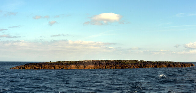
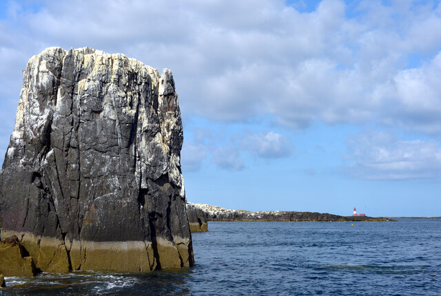
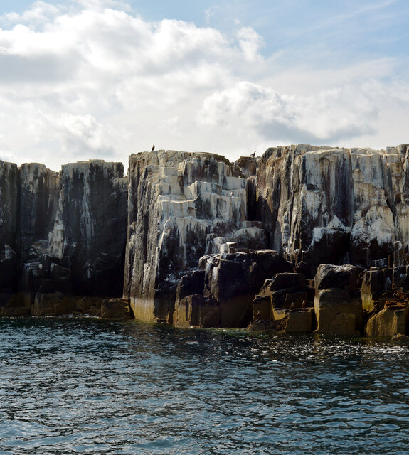
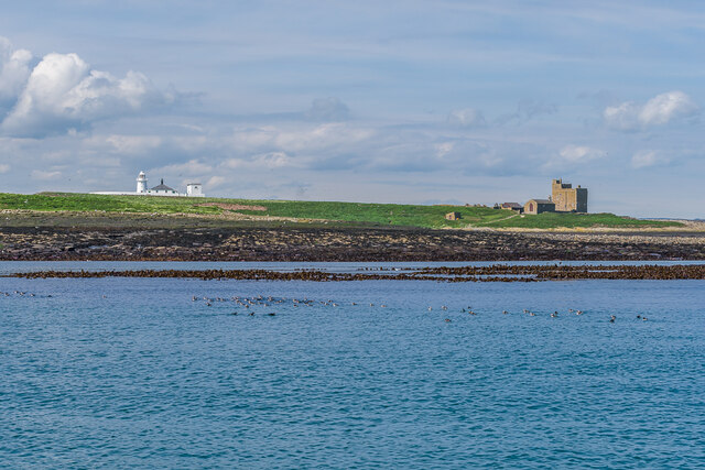
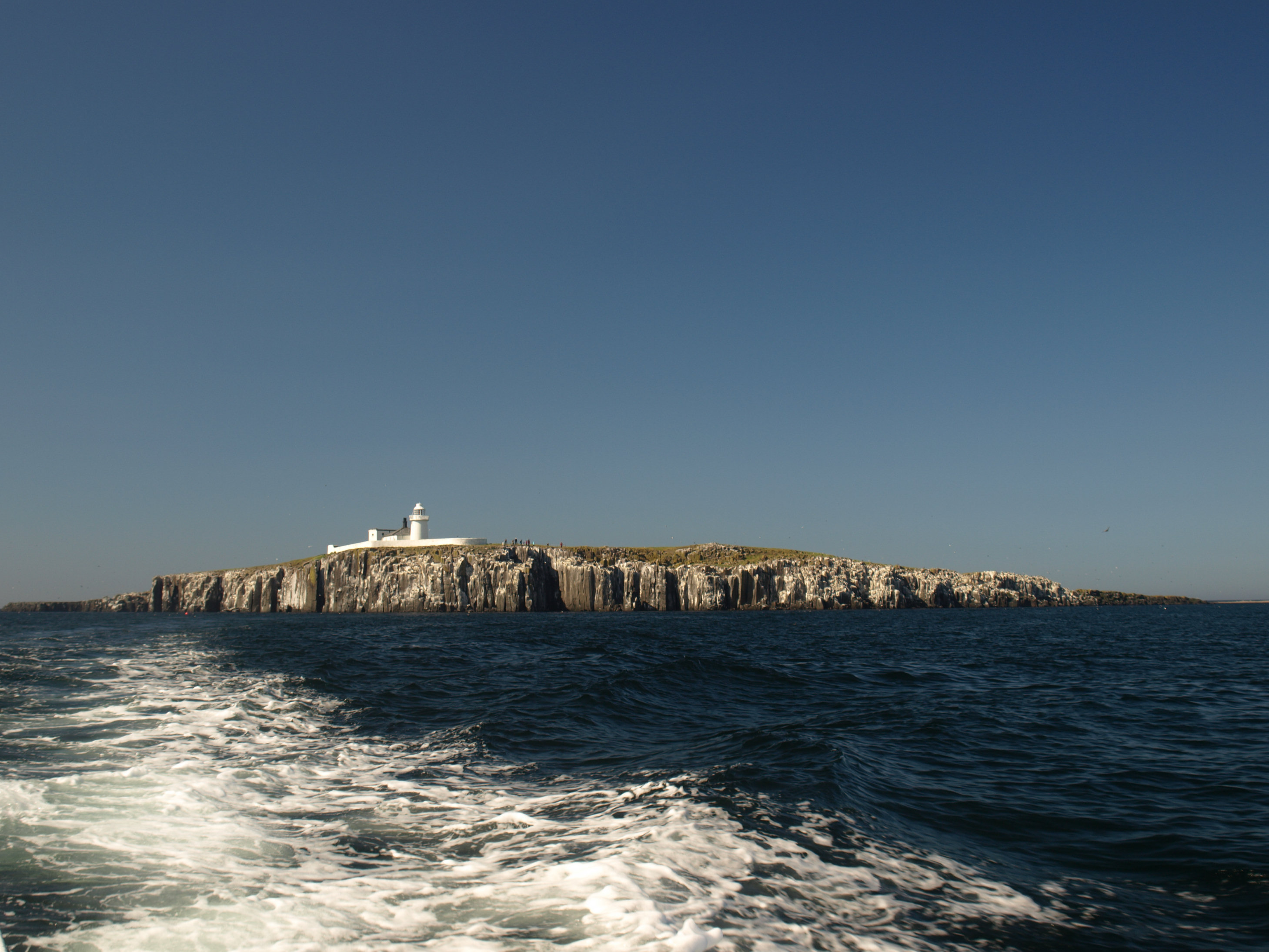
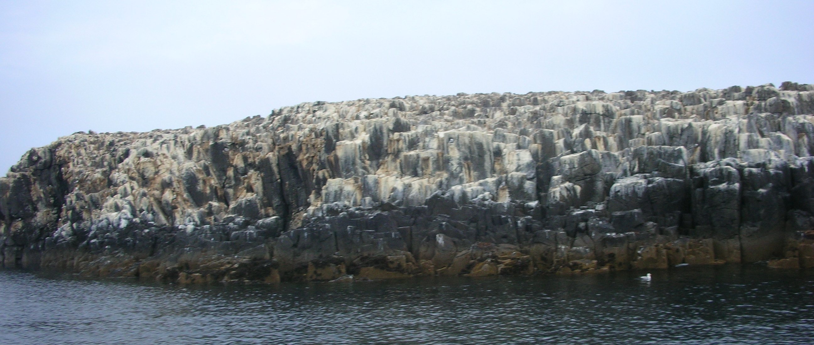
Big Scarcar is a small uninhabited island located off the coast of Northumberland, England. Situated in the North Sea, it is part of the Farne Islands group, which is known for its rich wildlife and historical significance. The island covers an area of approximately 4.5 acres and boasts a rugged terrain with steep cliffs and rocky outcrops.

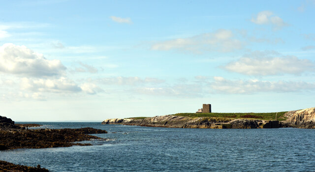
The name "Scarcar" is derived from the Old Norse word "sker," meaning a small rocky island. It is believed to have been used as a Viking outpost during the medieval period, evident from the presence of a defensive structure on the island's highest point. Today, remnants of this structure can still be seen, offering visitors a glimpse into the island's historical past.

Big Scarcar is a sanctuary for various seabird species, including puffins, guillemots, and razorbills, which nest on its cliffs during the breeding season. The island also serves as a vital breeding ground for grey seals, which come ashore to give birth to their pups during the autumn months.

Access to Big Scarcar is strictly controlled to protect its fragile ecosystem, and visitors are required to obtain special permits and follow conservation guidelines. The island can be reached by boat from nearby Seahouses, which offers regular tours to the Farne Islands. These tours provide visitors with the opportunity to observe the diverse wildlife and learn about the island's fascinating history.

Overall, Big Scarcar is a captivating island that combines natural beauty, historical significance, and abundant wildlife, making it a must-visit destination for nature enthusiasts and history buffs alike.

If you have any feedback on the listing, please let us know in the comments section below.

Big Scarcar Images

Images are sourced within 2km of 55.617152/-1.6395999 or Grid Reference NU2236. Thanks to Geograph Open Source API. All images are credited.

Inner Farne, West Wideopen and East Wideopen, The Farne Islands A group of 15 - 20 islands (depending on the tides) offshore of Seahouses, Northumberland. They are the most easterly outcrops of the Whin Sill (a dolerite intrusion across north east England). The islands are divided into the inner and outer islands. The Islands are an important breeding ground for many seabirds having a large Puffin population. There is also an important seal colony here. The whole area is designated a National Nature Reserve.
Wikipedia: <span class="nowrap"><a title="http://en.wikipedia.org/wiki/Farne_Islands" rel="nofollow ugc noopener" href="http://en.wikipedia.org/wiki/Farne_Islands">Link</a><img style="margin-left:2px;" alt="External link" title="External link - shift click to open in new window" src="https://s1.geograph.org.uk/img/external.png" width="10" height="10"/></span>
Inner Farne, West Wideopen and East Wideopen, The Farne Islands
A group of 15 - 20 islands (depending on the tides) offshore of Seahouses, Northumberland. They are the most easterly outcrops of the Whin Sill (a dolerite intrusion across north east England). The islands are divided into the inner and outer islands. The Islands are an important breeding ground for many seabirds having a large Puffin population. There is also an important seal colony here. The whole area is designated a National Nature Reserve. Wikipedia: LinkExternal link
Big Scarcar, The Farne Islands A group of 15 - 20 islands (depending on the tides) offshore of Seahouses, Northumberland. They are the most easterly outcrops of the Whin Sill (a dolerite intrusion across north east England). The islands are divided into the inner and outer islands. The Islands are an important breeding ground for many seabirds having a large Puffin population. There is also an important seal colony here. The whole area is designated a National Nature Reserve.
Wikipedia: <span class="nowrap"><a title="http://en.wikipedia.org/wiki/Farne_Islands" rel="nofollow ugc noopener" href="http://en.wikipedia.org/wiki/Farne_Islands">Link</a><img style="margin-left:2px;" alt="External link" title="External link - shift click to open in new window" src="https://s1.geograph.org.uk/img/external.png" width="10" height="10"/></span>
Big Scarcar, The Farne Islands
A group of 15 - 20 islands (depending on the tides) offshore of Seahouses, Northumberland. They are the most easterly outcrops of the Whin Sill (a dolerite intrusion across north east England). The islands are divided into the inner and outer islands. The Islands are an important breeding ground for many seabirds having a large Puffin population. There is also an important seal colony here. The whole area is designated a National Nature Reserve. Wikipedia: LinkExternal link
Staple Island, The Farne Islands A group of 15 - 20 islands (depending on the tides) offshore of Seahouses, Northumberland. They are the most easterly outcrops of the Whin Sill (a dolerite intrusion across north east England). The islands are divided into the inner and outer islands. The Islands are an important breeding ground for many seabirds having a large Puffin population. There is also an important seal colony here. The whole area is designated a National Nature Reserve.
Wikipedia: <span class="nowrap"><a title="http://en.wikipedia.org/wiki/Farne_Islands" rel="nofollow ugc noopener" href="http://en.wikipedia.org/wiki/Farne_Islands">Link</a><img style="margin-left:2px;" alt="External link" title="External link - shift click to open in new window" src="https://s1.geograph.org.uk/img/external.png" width="10" height="10"/></span>
Staple Island, The Farne Islands
A group of 15 - 20 islands (depending on the tides) offshore of Seahouses, Northumberland. They are the most easterly outcrops of the Whin Sill (a dolerite intrusion across north east England). The islands are divided into the inner and outer islands. The Islands are an important breeding ground for many seabirds having a large Puffin population. There is also an important seal colony here. The whole area is designated a National Nature Reserve. Wikipedia: LinkExternal link
The Pinnacles, Staple Island, The Farne Islands A group of 15 - 20 islands (depending on the tides) offshore of Seahouses, Northumberland. They are the most easterly outcrops of the Whin Sill (a dolerite intrusion across north east England). The islands are divided into the inner and outer islands. The Islands are an important breeding ground for many seabirds having a large Puffin population. There is also an important seal colony here. The whole area is designated a National Nature Reserve.
Wikipedia: <span class="nowrap"><a title="http://en.wikipedia.org/wiki/Farne_Islands" rel="nofollow ugc noopener" href="http://en.wikipedia.org/wiki/Farne_Islands">Link</a><img style="margin-left:2px;" alt="External link" title="External link - shift click to open in new window" src="https://s1.geograph.org.uk/img/external.png" width="10" height="10"/></span>
The Pinnacles, Staple Island, The Farne Islands
A group of 15 - 20 islands (depending on the tides) offshore of Seahouses, Northumberland. They are the most easterly outcrops of the Whin Sill (a dolerite intrusion across north east England). The islands are divided into the inner and outer islands. The Islands are an important breeding ground for many seabirds having a large Puffin population. There is also an important seal colony here. The whole area is designated a National Nature Reserve. Wikipedia: LinkExternal link
Staple Island, The Farne Islands A group of 15 - 20 islands (depending on the tides) offshore of Seahouses, Northumberland. They are the most easterly outcrops of the Whin Sill (a dolerite intrusion across north east England). The islands are divided into the inner and outer islands. The Islands are an important breeding ground for many seabirds having a large Puffin population. There is also an important seal colony here. The whole area is designated a National Nature Reserve.
Wikipedia: <span class="nowrap"><a title="http://en.wikipedia.org/wiki/Farne_Islands" rel="nofollow ugc noopener" href="http://en.wikipedia.org/wiki/Farne_Islands">Link</a><img style="margin-left:2px;" alt="External link" title="External link - shift click to open in new window" src="https://s1.geograph.org.uk/img/external.png" width="10" height="10"/></span>
Staple Island, The Farne Islands
A group of 15 - 20 islands (depending on the tides) offshore of Seahouses, Northumberland. They are the most easterly outcrops of the Whin Sill (a dolerite intrusion across north east England). The islands are divided into the inner and outer islands. The Islands are an important breeding ground for many seabirds having a large Puffin population. There is also an important seal colony here. The whole area is designated a National Nature Reserve. Wikipedia: LinkExternal link
The Farne Islands Longstones lighthouse can be beyond Brownsman. The Pinnacles of Staple Island are in the foreground.
The Farne Islands
Longstones lighthouse can be beyond Brownsman. The Pinnacles of Staple Island are in the foreground.
Staple Island, The Farne Islands A group of 15 - 20 islands (depending on the tides) offshore of Seahouses, Northumberland. They are the most easterly outcrops of the Whin Sill (a dolerite intrusion across north east England). The islands are divided into the inner and outer islands. The Islands are an important breeding ground for many seabirds having a large Puffin population. There is also an important seal colony here. The whole area is designated a National Nature Reserve.
Wikipedia: <span class="nowrap"><a title="http://en.wikipedia.org/wiki/Farne_Islands" rel="nofollow ugc noopener" href="http://en.wikipedia.org/wiki/Farne_Islands">Link</a><img style="margin-left:2px;" alt="External link" title="External link - shift click to open in new window" src="https://s1.geograph.org.uk/img/external.png" width="10" height="10"/></span>
Staple Island, The Farne Islands
A group of 15 - 20 islands (depending on the tides) offshore of Seahouses, Northumberland. They are the most easterly outcrops of the Whin Sill (a dolerite intrusion across north east England). The islands are divided into the inner and outer islands. The Islands are an important breeding ground for many seabirds having a large Puffin population. There is also an important seal colony here. The whole area is designated a National Nature Reserve. Wikipedia: LinkExternal link
Brownsman seen from Pinnacles Haven, The Farne Islands A group of 15 - 20 islands (depending on the tides) offshore of Seahouses, Northumberland. They are the most easterly outcrops of the Whin Sill (a dolerite intrusion across north east England). The islands are divided into the inner and outer islands. The Islands are an important breeding ground for many seabirds having a large Puffin population. There is also an important seal colony here. The whole area is designated a National Nature Reserve.
Wikipedia: <span class="nowrap"><a title="http://en.wikipedia.org/wiki/Farne_Islands" rel="nofollow ugc noopener" href="http://en.wikipedia.org/wiki/Farne_Islands">Link</a><img style="margin-left:2px;" alt="External link" title="External link - shift click to open in new window" src="https://s1.geograph.org.uk/img/external.png" width="10" height="10"/></span>
Brownsman seen from Pinnacles Haven, The Farne Islands
A group of 15 - 20 islands (depending on the tides) offshore of Seahouses, Northumberland. They are the most easterly outcrops of the Whin Sill (a dolerite intrusion across north east England). The islands are divided into the inner and outer islands. The Islands are an important breeding ground for many seabirds having a large Puffin population. There is also an important seal colony here. The whole area is designated a National Nature Reserve. Wikipedia: LinkExternal link
Inner Farne, The Farne Islands The ruins of a chapel are in the distance.
Inner Farne, The Farne Islands
The ruins of a chapel are in the distance.
Inner Farne Lighthouse, The Farne Islands A group of 15 - 20 islands (depending on the tides) offshore of Seahouses, Northumberland. They are the most easterly outcrops of the Whin Sill (a dolerite intrusion across north east England). The islands are divided into the inner and outer islands. The Islands are an important breeding ground for many seabirds having a large Puffin population. There is also an important seal colony here. The whole area is designated a National Nature Reserve.
Wikipedia: <span class="nowrap"><a title="http://en.wikipedia.org/wiki/Farne_Islands" rel="nofollow ugc noopener" href="http://en.wikipedia.org/wiki/Farne_Islands">Link</a><img style="margin-left:2px;" alt="External link" title="External link - shift click to open in new window" src="https://s1.geograph.org.uk/img/external.png" width="10" height="10"/></span>
Inner Farne Lighthouse, The Farne Islands
A group of 15 - 20 islands (depending on the tides) offshore of Seahouses, Northumberland. They are the most easterly outcrops of the Whin Sill (a dolerite intrusion across north east England). The islands are divided into the inner and outer islands. The Islands are an important breeding ground for many seabirds having a large Puffin population. There is also an important seal colony here. The whole area is designated a National Nature Reserve. Wikipedia: LinkExternal link
Inner Farne Lighthouse, The Farne Islands
Inner Farne The largest of the Farne Islands and, as its name implies, the nearest to the mainland.  The lighthouse was built in 1810 and Prior Castell's Tower, on the right, is thought to date from around 1500 but may be earlier.
Inner Farne
The largest of the Farne Islands and, as its name implies, the nearest to the mainland. The lighthouse was built in 1810 and Prior Castell's Tower, on the right, is thought to date from around 1500 but may be earlier.
Inner Farne and West Wideopen Looking towards Inner Farne, the largest of the Farne Islands and, as its name implies, the nearest to the mainland, with part of West Wideopen (usually a separate island but connected at low tide) on the right.  The lighthouse on Inner Farne was built in 1810 and Prior Castell's Tower, on the right, is thought to date from around 1500 but may be earlier.
Inner Farne and West Wideopen
Looking towards Inner Farne, the largest of the Farne Islands and, as its name implies, the nearest to the mainland, with part of West Wideopen (usually a separate island but connected at low tide) on the right. The lighthouse on Inner Farne was built in 1810 and Prior Castell's Tower, on the right, is thought to date from around 1500 but may be earlier.
Inner Farne and West Wideopen Looking across the low island of West Wideopen with Inner Farne beyond.  The two islands are usually separate but are connected at low tide.  Inner Farne is the largest of the Farne Islands and, as its name implies, the nearest to the mainland.  The lighthouse was built in 1810 and Prior Castell's Tower, on the right, is thought to date from around 1500 but may be earlier.
Inner Farne and West Wideopen
Looking across the low island of West Wideopen with Inner Farne beyond. The two islands are usually separate but are connected at low tide. Inner Farne is the largest of the Farne Islands and, as its name implies, the nearest to the mainland. The lighthouse was built in 1810 and Prior Castell's Tower, on the right, is thought to date from around 1500 but may be earlier.
Inner Farne and East Wideopen The rocky end of the island of East Wideopen with Inner Farne beyond.  Inner Farne is the largest of the Farne Islands and, as its name implies, the nearest to the mainland.  The lighthouse was built in 1810.

In the left background is Bamburgh Castle.
Inner Farne and East Wideopen
The rocky end of the island of East Wideopen with Inner Farne beyond. Inner Farne is the largest of the Farne Islands and, as its name implies, the nearest to the mainland. The lighthouse was built in 1810. In the left background is Bamburgh Castle.
The Bush The low rock reef of The Bush, usually underwater but visible at low tide, as here.  In the far distance is Dunstanburgh Castle, around 15 km away.

On the horizon in the centre of the photo is what would appear to be a buoy, which I believe to be North Sunderland Buoy, offshore from North Sunderland Point near Seahouses.
The Bush
The low rock reef of The Bush, usually underwater but visible at low tide, as here. In the far distance is Dunstanburgh Castle, around 15 km away. On the horizon in the centre of the photo is what would appear to be a buoy, which I believe to be North Sunderland Buoy, offshore from North Sunderland Point near Seahouses.
Show me another place!

Big Scarcar is located at Grid Ref: NU2236 (Lat: 55.617152, Lng: -1.6395999)

Unitary Authority: Northumberland

Police Authority: Northumbria

What 3 Words

///weep.spill.bibs. Near Seahouses, Northumberland

Related Wikis

Farne Islands

The Farne Islands are a group of islands off the coast of Northumberland, England. The group has between 15 and 20 islands depending on the level of the...
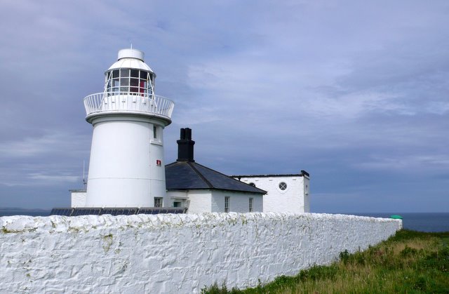
Farne Lighthouse

Farne Lighthouse is a lighthouse on the southern tip of Inner Farne (one of a group of islands off the coast of North Northumberland). Built in the early...

Staple Island

Staple Island is a small rocky island, or skerry, that is one of the Outer Group of the Farne Islands in Northumberland, England. The Farne Islands are...

Forfarshire (ship)

Forfarshire was a paddle steamer with brigantine rigging, built in Dundee in 1834, and which struck and later foundered on one of the Farne Islands on...

Nearby Amenities

Located within 500m of 55.617152,-1.6395999
The Bush
Place: locality
Lat/Long: 55.6176252/-1.6335813
Wreck of trawler "Children's Friend"
Historic: ruins
Lat/Long: 55.6166491/-1.6474393
The data included in this document is from www.openstreetmap.org. The data is made available under ODbL.

Have you been to Big Scarcar?

Leave your review of Big Scarcar below (or comments, questions and feedback).