Boinna Skerry

Island in Shetland

Scotland

Boinna Skerry

Hurdibrack The last stretch of the footpath back from the west side of the island. In the middle distance is the wall which crosses the entire island, separating the arable land in the east from the pasture to the west.
Hurdibrack Credit: Anne Burgess

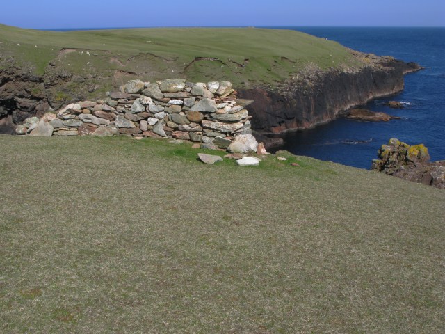
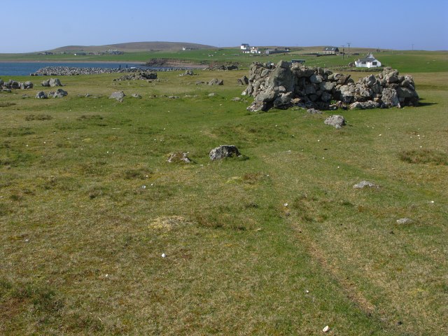
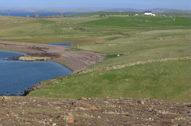
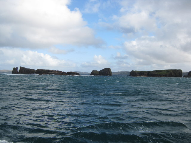
Boinna Skerry is a small island located in the Shetland archipelago, situated in the North Atlantic Ocean. It is one of the many uninhabited islands in the region, known for its rugged beauty and diverse wildlife.

Measuring approximately 0.15 square kilometers in area, Boinna Skerry is characterized by its rocky cliffs and scattered vegetation. The island is primarily composed of ancient volcanic rocks, which give it a distinctive appearance. The coastline is dotted with caves and sea stacks, adding to its scenic appeal.

Boinna Skerry is a haven for seabirds, with large colonies of puffins, guillemots, and razorbills nesting on its cliffs. These birds can be observed during the breeding season, which typically runs from April to August. The island is also home to various other species, including seals and otters, which can often be spotted along the shore.

Access to Boinna Skerry is limited due to its remote location and lack of facilities. It is only reachable by boat, and visitors are advised to exercise caution, as the waters surrounding the island can be treacherous. Despite its limited accessibility, Boinna Skerry attracts nature enthusiasts and birdwatchers who are drawn to its untouched landscapes and abundant wildlife.

Overall, Boinna Skerry is a picturesque and ecologically significant island in the Shetland archipelago. Its dramatic cliffs, diverse birdlife, and rugged charm make it an appealing destination for those seeking a truly remote and natural experience.

If you have any feedback on the listing, please let us know in the comments section below.

Boinna Skerry Images

Images are sourced within 2km of 60.332827/-1.6650423 or Grid Reference HU1861. Thanks to Geograph Open Source API. All images are credited.

Hurdibrack The last stretch of the footpath back from the west side of the island. In the middle distance is the wall which crosses the entire island, separating the arable land in the east from the pasture to the west.
Hurdibrack
The last stretch of the footpath back from the west side of the island. In the middle distance is the wall which crosses the entire island, separating the arable land in the east from the pasture to the west.
The Wall This is the wall which cuts across the whole island. The west side (left) has a steep face to prevent animals climbing over it. The east (right) side has a sloping face so that any animals which have managed to cross it can easily be driven back on to the pasture land.
The Wall
This is the wall which cuts across the whole island. The west side (left) has a steep face to prevent animals climbing over it. The east (right) side has a sloping face so that any animals which have managed to cross it can easily be driven back on to the pasture land.
Robie's Noust This is a very dull shot of a square which would certainly have yielded a more interesting image if we had had time to explore it before the ferry left.
Robie's Noust
This is a very dull shot of a square which would certainly have yielded a more interesting image if we had had time to explore it before the ferry left.
The Dales As with the next-door square, HU1861 would certainly have yielded a more interesting shot if we had not had to rush to catch the ferry!
The Dales
As with the next-door square, HU1861 would certainly have yielded a more interesting shot if we had not had to rush to catch the ferry!
Papa Stour Pier and Ferry The ferry runs regularly but infrequently, so that day trips to the island are only possible on Fridays or Saturdays.
Papa Stour Pier and Ferry
The ferry runs regularly but infrequently, so that day trips to the island are only possible on Fridays or Saturdays.
Ruined House
Ruined House
Ruined house The number of ruined buildings on the island seem to far outnumber those still habitable or used.
Ruined house
The number of ruined buildings on the island seem to far outnumber those still habitable or used.
Road and ruins This is the main road for the island.  Even this close to the pier the ruins of abandoned crofts can be found just off the road.
Road and ruins
This is the main road for the island. Even this close to the pier the ruins of abandoned crofts can be found just off the road.
View towards Papa Stour Airstrip The cleared and smoothed ground in the upper right of the image is the airstrip for Papa Stour which is located in <a href="https://www.geograph.org.uk/gridref/HU1759">HU1759</a>.
View towards Papa Stour Airstrip
The cleared and smoothed ground in the upper right of the image is the airstrip for Papa Stour which is located in HU1759.
Rocky coastline
Rocky coastline
View from North Ness The view here is from North Ness towards the highest point on the island.

The ground shown in the foreground is typical of this rather barren area.
View from North Ness
The view here is from North Ness towards the highest point on the island. The ground shown in the foreground is typical of this rather barren area.
The "New" Pier The image here is taken from the old pier looking towards the new pier.

The line of rusting fenceposts serves no useful purpose.

The rocks along the shoreline are very popular with young seals - although they proved to be somewhat camera-shy.
The "New" Pier
The image here is taken from the old pier looking towards the new pier. The line of rusting fenceposts serves no useful purpose. The rocks along the shoreline are very popular with young seals - although they proved to be somewhat camera-shy.
A puzzling wall The purpose of this isolated section of wall is far from clear: you might think that perhaps it was in place to stop sheep wandering down onto the rocks beyond, but it would seem to be easy enough for them to walk around the wall.
A puzzling wall
The purpose of this isolated section of wall is far from clear: you might think that perhaps it was in place to stop sheep wandering down onto the rocks beyond, but it would seem to be easy enough for them to walk around the wall.
Ruined homestead
Ruined homestead
Oystercatcher nest with eggs This nest was located in the pebbles at the high-point of the beach.  The eggs are camouflaged to be hard to see amongst the pebbles - although thankfully these were just noticeable enough to escape being trodden on.

The oystercatchers seem to be surviving relatively well on the island, whilst the previously abundant tern population has been largely destroyed by the skuas.
Oystercatcher nest with eggs
This nest was located in the pebbles at the high-point of the beach. The eggs are camouflaged to be hard to see amongst the pebbles - although thankfully these were just noticeable enough to escape being trodden on. The oystercatchers seem to be surviving relatively well on the island, whilst the previously abundant tern population has been largely destroyed by the skuas.
Ruined mill complete with stream This side of the island has many disused mills, all situated on the outflows of the few sizeable lochans found here.  This mill, unique amongst those that I observed, still has some water running through it - all others appear to have had the channels blocked off at some point.

It should be noted that most of the usable arable land is/was on the other side of the island.  The mills have been located on this northwest side of the island presumably to be close to the supplies of water.
Ruined mill complete with stream
This side of the island has many disused mills, all situated on the outflows of the few sizeable lochans found here. This mill, unique amongst those that I observed, still has some water running through it - all others appear to have had the channels blocked off at some point. It should be noted that most of the usable arable land is/was on the other side of the island. The mills have been located on this northwest side of the island presumably to be close to the supplies of water.
View towards Hurdiback
Derelict farm equipment at Gardie Papa Stour's resident population is down to 8 so there are sadly some signs of dereliction.
Derelict farm equipment at Gardie
Papa Stour's resident population is down to 8 so there are sadly some signs of dereliction.
Show me another place!

Boinna Skerry is located at Grid Ref: HU1861 (Lat: 60.332827, Lng: -1.6650423)

Unitary Authority: Shetland Islands

Police Authority: Highlands and Islands

What 3 Words

///strain.shot.unloaded. Near Walls, Shetland Islands

Related Wikis

Maiden Stack

The Maiden Stack or Frau Stack is a tiny stack in the western Shetland Islands to the north of Brei Holm and east of Housa Voe about 140 metres (150 yd...

Brei Holm

Brei Holm is a tiny tidal islet in the western Shetland Islands. It is due east of Papa Stour, to which it is connected at low tide, just outside Housa...

Biggings

Biggings is a village on the island of Papa Stour, in Shetland, Scotland. Papa Stour's church is situated at the south of Biggings. A homestead of Duke...

Forewick Holm

Forewick Holm is a 1-hectare (2.5-acre) island in the Sound of Papa, between Papa Stour and the Mainland of Shetland. It lies adjacent to a skerry called...

Nearby Amenities

Located within 500m of 60.332827,-1.6650423
Ferry Terminal
Lat/Long: 60.3313125/-1.6717
Power: pole
Lat/Long: 60.3323411/-1.6729541
Power: pole
Lat/Long: 60.3323565/-1.6727695
The data included in this document is from www.openstreetmap.org. The data is made available under ODbL.

Have you been to Boinna Skerry?

Leave your review of Boinna Skerry below (or comments, questions and feedback).