Muckle Skerry

Island in Orkney

Scotland

Muckle Skerry

Faray View to the island with Broad Sand Geo to the left and Long Sand Geo right on the shore. The abandoned dwelling to the left of picture on the horizon is Cott.
Faray Credit: Andy Farrington

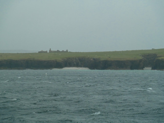
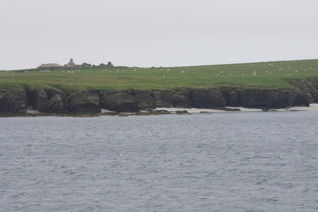
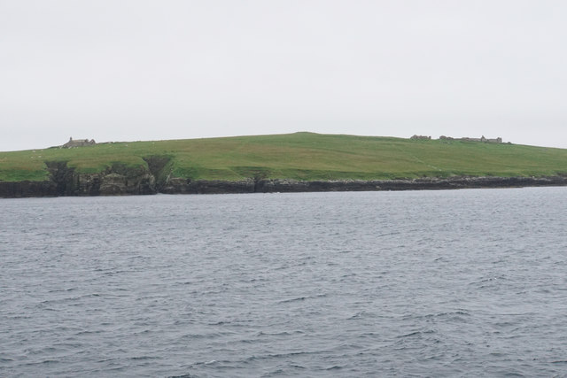
Muckle Skerry is a small, uninhabited island located off the north coast of Scotland in the Orkney archipelago. The island is part of the North Isles group and is situated approximately 1.5 miles northeast of the larger island of Eday.

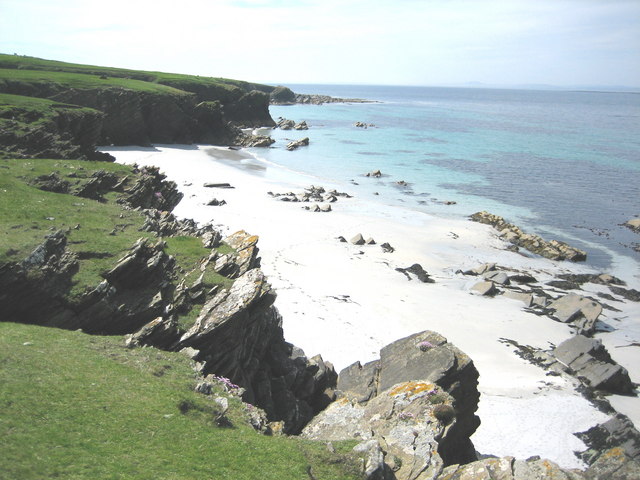
Muckle Skerry is known for its rugged and rocky terrain, with cliffs rising steeply from the surrounding sea. The island is home to a variety of seabirds, including puffins, guillemots, and razorbills, making it a popular spot for birdwatching.

The island has no permanent residents and is only accessible by boat. It is a popular destination for day trips and wildlife enthusiasts looking to explore its natural beauty and observe the diverse bird populations.

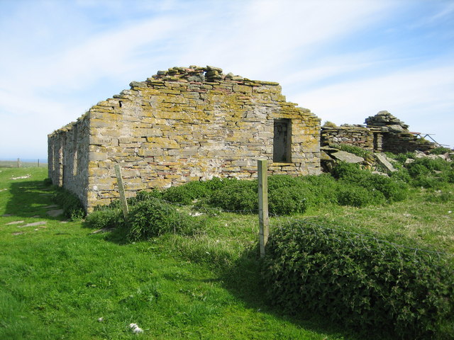
Muckle Skerry has a rich history, with evidence of ancient settlements and burial sites dating back to the Neolithic period. The island also played a role in World War II, serving as a lookout post for monitoring enemy activity in the surrounding waters.

Overall, Muckle Skerry is a remote and picturesque island with a rich history and diverse wildlife, making it a must-visit destination for nature lovers and history buffs alike.

If you have any feedback on the listing, please let us know in the comments section below.

Muckle Skerry Images

Images are sourced within 2km of 59.205635/-2.8284668 or Grid Reference HY5235. Thanks to Geograph Open Source API. All images are credited.

Faray View to the island with Broad Sand Geo to the left and Long Sand Geo right on the shore. The abandoned dwelling to the left of picture on the horizon is Cott.
Faray
View to the island with Broad Sand Geo to the left and Long Sand Geo right on the shore. The abandoned dwelling to the left of picture on the horizon is Cott.
Langie Geos View to Faray with the abandoned Windywall dwelling left of picture.
Langie Geos
View to Faray with the abandoned Windywall dwelling left of picture.
Point of Scaraber Passing the southern tip of Faray on route to Kirkwall.
Point of Scaraber
Passing the southern tip of Faray on route to Kirkwall.
Eday Passing by Fers Ness the northern tip of the island on route to Kirkwall.
Eday
Passing by Fers Ness the northern tip of the island on route to Kirkwall.
Rammy Geo, Eday View to the shore with Fersness Farm on the horizon.
Rammy Geo, Eday
View to the shore with Fersness Farm on the horizon.
Cliffs of Faray The beginning of a sandy beach which is not very accessible. On top is an abandoned croft called Cott.
Cliffs of Faray
The beginning of a sandy beach which is not very accessible. On top is an abandoned croft called Cott.
The west coast of Faray Ruined crofts are behind, the largest one being called Roadside.
The west coast of Faray
Ruined crofts are behind, the largest one being called Roadside.
The west coast of Faray Langie Geos are to the left with Windywall croft behind. Holland croft is to the right.
The west coast of Faray
Langie Geos are to the left with Windywall croft behind. Holland croft is to the right.
Fers Ness A headland in the west of Eday. You can see the Sands of Doomy behind.
Fers Ness
A headland in the west of Eday. You can see the Sands of Doomy behind.
The west coast of Eday A low but significant cliff. Fersness Farm is on top of the rise behind. A new barn has been built since this image: <a href="https://www.geograph.org.uk/photo/3492747">HY5233 : Rammy Geo, Eday</a>.
The west coast of Eday
A low but significant cliff. Fersness Farm is on top of the rise behind. A new barn has been built since this image: HY5233 : Rammy Geo, Eday.
Ruined farm, Faray Rapness Sound and Westray in background
Ruined farm, Faray
Rapness Sound and Westray in background
Eday from Faray Sound of Faray and Fersness Bay in background
Eday from Faray
Sound of Faray and Fersness Bay in background
Bothy, Rusk Holm The bothy is now only occasionally used by sheep farmers who manage the islands flock of North Ronaldsay sheep. The large chimney was reputedly used to burn kelp.
Bothy, Rusk Holm
The bothy is now only occasionally used by sheep farmers who manage the islands flock of North Ronaldsay sheep. The large chimney was reputedly used to burn kelp.
Signs of habitation, Rusk Holm The remains of what appears to be two gable ends and a short section of dyke are all that remain of past habitation on the north tip of this remote island.
Signs of habitation, Rusk Holm
The remains of what appears to be two gable ends and a short section of dyke are all that remain of past habitation on the north tip of this remote island.
Going ashore, Djubi Geo, Faray There are very few landing sites on the Island of Faray.  Djubi Geo is one of the best.  Depending on wind, weather and tides it is used for landing and taking off sheep.
Going ashore, Djubi Geo, Faray
There are very few landing sites on the Island of Faray. Djubi Geo is one of the best. Depending on wind, weather and tides it is used for landing and taking off sheep.
Burial Ground, Faray Most of the 30 or so gravestones date from the mid 1800s to the early 1900s. Stony rubble (not visible in the photo) in the southeast corner of the walled enclosure indicates the site of an earlier chapel.
Burial Ground, Faray
Most of the 30 or so gravestones date from the mid 1800s to the early 1900s. Stony rubble (not visible in the photo) in the southeast corner of the walled enclosure indicates the site of an earlier chapel.
Doggerboat Farmhouse (east side), Faray In 1881 Faray had nine named houses according to the census, however the island has neen uninhabited since shortly after World War II.
Doggerboat Farmhouse (east side), Faray
In 1881 Faray had nine named houses according to the census, however the island has neen uninhabited since shortly after World War II.
Long Sand, Faray The name suggested for this beautiful sandy beach is based on the 1880 (revised 1900, 2nd edition printed 1903) Ordnance Survey map's name for the large geo located halfway along the beach.  The scale for the referenced map is 6 inches = 1 mile.
Long Sand, Faray
The name suggested for this beautiful sandy beach is based on the 1880 (revised 1900, 2nd edition printed 1903) Ordnance Survey map's name for the large geo located halfway along the beach. The scale for the referenced map is 6 inches = 1 mile.
Show me another place!

Muckle Skerry is located at Grid Ref: HY5235 (Lat: 59.205635, Lng: -2.8284668)

Unitary Authority: Orkney Islands

Police Authority: Highlands and Islands

What 3 Words

///rift.staining.tangible. Near Backaland, Orkney Islands

Related Wikis

Faray

Faray (Old Norse: Færey) is a small island in Orkney, Scotland, lying between Eday and Westray. Previously inhabited, the low-lying island is now a successful...

Rusk Holm

Rusk Holm is a small island in the Orkney Islands, near Faray to the west. == History == There is a prehistoric cairn on it . Rusk Holm is also home to...

Holm of Faray

The Holm of Faray is a small island in Orkney, Scotland, near Faray and Westray, which it lies between. Together with its neighbour Faray, it is designated...

Eday

Eday (, Scots: Aidee) is one of the islands of Orkney, which are located to the north of the Scottish mainland. One of the North Isles, Eday is about 24...

Nearby Amenities

Located within 500m of 59.205635,-2.8284668
Well Geo
Natural: bay
Lat/Long: 59.209778/-2.8274817
Point of Scaraber
Place: locality
Lat/Long: 59.2037191/-2.8229076
Bight of Sandbister
Natural: bay
Lat/Long: 59.2091364/-2.8296359
Scammalin
Natural: bay
Lat/Long: 59.205077/-2.8206517
The data included in this document is from www.openstreetmap.org. The data is made available under ODbL.

Have you been to Muckle Skerry?

Leave your review of Muckle Skerry below (or comments, questions and feedback).