Louther Skerry

Island in Orkney

Scotland

Louther Skerry

Muckle Skerry from the air Guarding the eastern approach to Pentland Firth.
Muckle Skerry from the air Credit: Bill Boaden

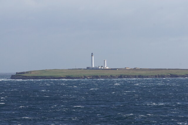
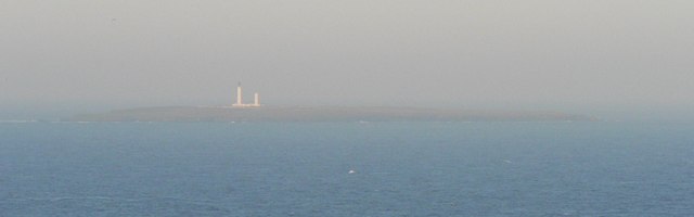
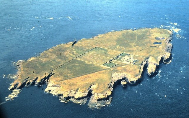
Louther Skerry is a small uninhabited island located in the Orkney archipelago, off the northern coast of mainland Scotland. It lies approximately 30 kilometers northwest of the Orkney mainland and is part of the North Isles group of islands. Louther Skerry is a rocky outcrop with steep cliffs rising up to 50 meters above sea level.

The island is known for its abundant birdlife. It is home to a large colony of Atlantic puffins, which nest in burrows on the island's grassy slopes during the breeding season. Other seabirds that can be spotted on Louther Skerry include guillemots, razorbills, fulmars, and kittiwakes. The surrounding waters are also rich in marine life, attracting seals and various species of whales and dolphins.

Due to its remote location and rugged terrain, Louther Skerry has never been permanently inhabited. However, the island has historical significance as a navigational aid. In the early 19th century, a lighthouse was built on the island to guide ships through the treacherous waters of the Pentland Firth. The lighthouse, which still stands today, is automated and maintained by the Northern Lighthouse Board.

Access to Louther Skerry is restricted to authorized personnel only, as it is a protected area for wildlife conservation. However, visitors can admire the island's beauty from afar by taking boat trips or participating in birdwatching tours in the surrounding waters. Louther Skerry offers a unique opportunity to experience the untamed beauty of the Orkney Islands and observe a diverse array of seabirds in their natural habitat.

If you have any feedback on the listing, please let us know in the comments section below.

Louther Skerry Images

Images are sourced within 2km of 58.679444/-2.8993654 or Grid Reference ND4777. Thanks to Geograph Open Source API. All images are credited.

Muckle Skerry from the air Guarding the eastern approach to Pentland Firth.
Muckle Skerry from the air
Guarding the eastern approach to Pentland Firth.
Muckle Skerry Aerial view of Muckle Skerry, taken on a flight from Inverness to Shetland via Orkney. The two towers of the lighthouse can clearly be seen - only the taller of these (on the left) now shows a light. For more details see <a href="https://www.geograph.org.uk/photo/754955">ND4678 : Muckle Skerry Lighthouse</a>
To the west (right on the image) the three little water features near the coast can be discerned. 
Behind the island can be seen two of the accompanying tiny skerry groups - almost level with the lighthouses is Louther Skerry at ND47917720 (showing as nothing much more than a whitish streak); and top left of the image is Clettack Skerry (ND48557757)
Muckle Skerry
Aerial view of Muckle Skerry, taken on a flight from Inverness to Shetland via Orkney. The two towers of the lighthouse can clearly be seen - only the taller of these (on the left) now shows a light. For more details see ND4678 : Muckle Skerry Lighthouse To the west (right on the image) the three little water features near the coast can be discerned. Behind the island can be seen two of the accompanying tiny skerry groups - almost level with the lighthouses is Louther Skerry at ND47917720 (showing as nothing much more than a whitish streak); and top left of the image is Clettack Skerry (ND48557757)
Muckle Skerry The largest of the Pentland Skerries. Rising to 20 metres above sea level, the term "Skerry" is strictly speaking not applicable to this island, unlike the neighbouring tidal rocks. 

The lighthouse  was built in 1794 by Thomas Smith and Robert Stevenson, one of a long line of distinguished lighthouse engineers. To the right of the operational light is a second lighthouse, now disused.
Muckle Skerry
The largest of the Pentland Skerries. Rising to 20 metres above sea level, the term "Skerry" is strictly speaking not applicable to this island, unlike the neighbouring tidal rocks. The lighthouse was built in 1794 by Thomas Smith and Robert Stevenson, one of a long line of distinguished lighthouse engineers. To the right of the operational light is a second lighthouse, now disused.
Muckle Skerry, Pentland Firth, at dawn
Muckle Skerry lighthouse A good view from the Pentland Venture ferry after leaving Burwick harbour
Muckle Skerry lighthouse
A good view from the Pentland Venture ferry after leaving Burwick harbour
Little Skerry, Pentland Skerries, from the sea Taken from about ND 4475
Little Skerry, Pentland Skerries, from the sea
Taken from about ND 4475
Muckle Skerry, Pentland Skerries, from the sea Taken from about ND 4476
Muckle Skerry, Pentland Skerries, from the sea
Taken from about ND 4476
Muckle Skerry: lighthouse A very distant view of Muckle Skerry, one of the Pentland Skerries, from Duncansby Head. See <span class="nowrap"><a title="http://en.wikipedia.org/wiki/Muckle_Skerry" rel="nofollow ugc noopener" href="http://en.wikipedia.org/wiki/Muckle_Skerry">Link</a><img style="margin-left:2px;" alt="External link" title="External link - shift click to open in new window" src="https://s1.geograph.org.uk/img/external.png" width="10" height="10"/></span>
Muckle Skerry: lighthouse
A very distant view of Muckle Skerry, one of the Pentland Skerries, from Duncansby Head. See LinkExternal link
Muckle Skerry Lighthouse Muckle Skerry lighthouse seen from the perimeter wall. Completed in 1794, it was the first lighthouse built by Robert Stevenson and T Smith. It originally consisted of two light towers but this was changed to a more powerful single light in 1895. The main lighthouse is 36 metres high. It became automated in 1994.
Muckle Skerry Lighthouse
Muckle Skerry lighthouse seen from the perimeter wall. Completed in 1794, it was the first lighthouse built by Robert Stevenson and T Smith. It originally consisted of two light towers but this was changed to a more powerful single light in 1895. The main lighthouse is 36 metres high. It became automated in 1994.
"The Dump", Muckle Skerry lighthouse This is where waste of all kinds was dumped from the lighthouse. Unless there was a Northerly gale blowing of course! The locals are enjoying the pleasant weather.
"The Dump", Muckle Skerry lighthouse
This is where waste of all kinds was dumped from the lighthouse. Unless there was a Northerly gale blowing of course! The locals are enjoying the pleasant weather.
Muckle Skerry from the air See <span class="nowrap"><a title="http://en.wikipedia.org/wiki/Muckle_Skerry" rel="nofollow ugc noopener" href="http://en.wikipedia.org/wiki/Muckle_Skerry">Link</a><img style="margin-left:2px;" alt="External link" title="External link - shift click to open in new window" src="https://s1.geograph.org.uk/img/external.png" width="10" height="10"/></span>
Muckle Skerry from the air
See LinkExternal link
Muckle Skerry Lighthouse
Show me another place!

Louther Skerry is located at Grid Ref: ND4777 (Lat: 58.679444, Lng: -2.8993654)

Unitary Authority: Orkney Islands

Police Authority: Highlands and Islands

What 3 Words

///chromatic.backup.wipes. Near John o' Groats, Highland

Related Wikis

Pentland Skerries

The Pentland Skerries (Old Norse: Pettlandssker) are a group of four uninhabited islands lying in the Pentland Firth, northeast of Duncansby Head and south...

SM U-18

SM U-18 was one of 329 submarines serving in the Imperial German Navy in World War I. U-18 engaged in the commerce warfare in the First Battle of the Atlantic...

Muckle Skerry

Muckle Skerry is the largest of the Pentland Skerries that lie off the north coast of Scotland. It is home to the Pentland Skerries Lighthouse. Muckle...

Tomb of the Eagles

The Tomb of the Eagles, or Isbister Chambered Cairn, is a Neolithic chambered tomb located on a cliff edge at Isbister on South Ronaldsay in Orkney, Scotland...

Have you been to Louther Skerry?

Leave your review of Louther Skerry below (or comments, questions and feedback).