Ealing, Little

Settlement in Middlesex

England

Ealing, Little

Palm House at Kew One of the large conservatories in the botanical gardens.
Palm House at Kew Credit: DS Pugh

Ealing, Little, Middlesex is a historic suburban area located in the western part of London, England. Ealing is primarily known for its picturesque neighborhood, vibrant atmosphere, and rich cultural heritage. It falls within the Ealing borough and is situated around 12 miles west of central London.

Ealing is renowned for its attractive residential streets, lined with Victorian and Edwardian houses, offering a charming and peaceful environment. The area boasts a variety of green spaces, including the beautiful Ealing Common and Walpole Park, providing residents with ample recreational opportunities.

Ealing is well-connected, with excellent transportation links. The Ealing Broadway station serves as a major transport hub, offering access to the London Underground Central and District lines, as well as various bus routes and the Great Western Main Line.

The area is home to a diverse community, with a mixture of families, professionals, and students. It offers a wide range of amenities, including numerous shops, restaurants, and cafes. Ealing Broadway Shopping Centre is a popular destination for retail therapy, featuring both high-street brands and independent stores.

Ealing is also known for its vibrant cultural scene. The Ealing Studios, one of the oldest film studios in the world, has produced numerous renowned films. Additionally, the area hosts various cultural events, including the Ealing Jazz Festival and the Ealing Summer Festivals.

Overall, Ealing, Little, Middlesex is a charming and sought-after suburb of London, providing residents with a peaceful and picturesque environment, excellent transport links, and a vibrant cultural scene.

If you have any feedback on the listing, please let us know in the comments section below.

Ealing, Little Images

Images are sourced within 2km of 51.49319/-0.308848 or Grid Reference TQ1778. Thanks to Geograph Open Source API. All images are credited.

Palm House at Kew One of the large conservatories in the botanical gardens.
Palm House at Kew
One of the large conservatories in the botanical gardens.
The Pond at Kew The pond is located opposite the Palm House.
The Pond at Kew
The pond is located opposite the Palm House.
Towards the Palm House Viewed from close to the Waterlily House
Towards the Palm House
Viewed from close to the Waterlily House
Looking towards the Palm House One of the large glasshouses within the botanical gardens.
Looking towards the Palm House
One of the large glasshouses within the botanical gardens.
Egyptian geese in Kew Looking towards the Palm House beside The Pond.
Egyptian geese in Kew
Looking towards the Palm House beside The Pond.
Cacti in the Princess of Wales Conservatory Part of the botanical gardens at Kew.
Cacti in the Princess of Wales Conservatory
Part of the botanical gardens at Kew.
Towards the Alpine House Looking towards the Alpine House and Princess of Wales Conservatory in Kew Gardens.
Towards the Alpine House
Looking towards the Alpine House and Princess of Wales Conservatory in Kew Gardens.
Pond near Sir Joseph Banks Building A pond in Kew Gardens.
Pond near Sir Joseph Banks Building
A pond in Kew Gardens.
Sir Joseph Banks Building One of a number of glasshouses in the botanical gardens at Kew.
Sir Joseph Banks Building
One of a number of glasshouses in the botanical gardens at Kew.
The Queen's Garden Looking towards Kew Palace across the Queen's Garden.
The Queen's Garden
Looking towards Kew Palace across the Queen's Garden.
Ferry Lane near Kew Palace Looking over the wall onto Ferry Lane from Kew Palace in Kew Botanical Gardens.
Ferry Lane near Kew Palace
Looking over the wall onto Ferry Lane from Kew Palace in Kew Botanical Gardens.
The Lake from the Lake Crossing Looking across part of a lake in Kew Gardens.
The Lake from the Lake Crossing
Looking across part of a lake in Kew Gardens.
Pitzhanger Manor: the garden front
Path through Walpole Park The path links the gardens of Pitzhanger Manor with Lammas Park further south.  The trees in the avenue are oaks and horse chestnuts.

I'm glad to report that the conker trees here seem to be pretty healthy - long may they stay that way.  Further south, in the Richmond area, the species has been seriously blighted in the last 20 years.
Path through Walpole Park
The path links the gardens of Pitzhanger Manor with Lammas Park further south. The trees in the avenue are oaks and horse chestnuts. I'm glad to report that the conker trees here seem to be pretty healthy - long may they stay that way. Further south, in the Richmond area, the species has been seriously blighted in the last 20 years.
Pitzhanger Manor from the west
Walpole Park fountain
Walpole Park
Walpole Park
Ealing : garden front, Pitzhanger Manor Pitzhanger Manor is Grade I listed, built to a design by architect, John Soane - <span class="nowrap"><a title="https://historicengland.org.uk/listing/the-list/list-entry/1358808?section=official-list-entry" rel="nofollow ugc noopener" href="https://historicengland.org.uk/listing/the-list/list-entry/1358808?section=official-list-entry">Link</a><img style="margin-left:2px;" alt="External link" title="External link - shift click to open in new window" src="https://s1.geograph.org.uk/img/external.png" width="10" height="10"/></span>.
Ealing : garden front, Pitzhanger Manor
Pitzhanger Manor is Grade I listed, built to a design by architect, John Soane - LinkExternal link.
Show me another place!

Ealing, Little is located at Grid Ref: TQ1778 (Lat: 51.49319, Lng: -0.308848)

Unitary Authority: Hounslow

Police Authority: Metropolitan

What 3 Words

///leave.agent.given. Near Brentford, London

Related Wikis

Gunnersbury Boys' School

Gunnersbury Boys' School is a Roman Catholic Secondary School for boys with specialist Science College status. It is situated in Brentford, London. The...

Ealing Fields High School

Ealing Fields High School is a coeducational secondary school, located in the London Borough of Ealing, England. The school site is on a Grade II listed...

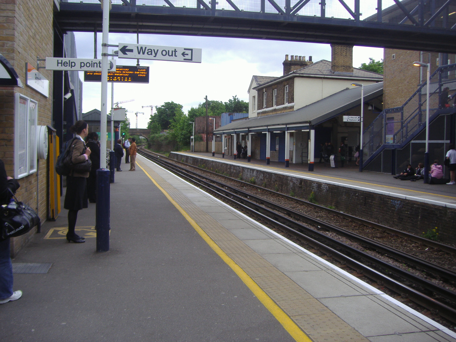
Brentford railway station

Brentford is a railway station in the town of Brentford, in Hounslow, London. It is on the Hounslow Loop Line and in Travelcard Zone 4. The station and...

Ealing and Old Brentford Cemetery

South Ealing Cemetery is a cemetery in South Ealing which was established in 1861 as Ealing and Old Brentford Cemetery. The cemetery covers 21 acres.The...
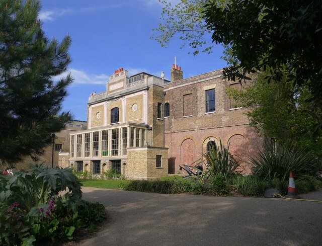
Boston Manor House

Boston Manor House is an English Jacobean manor house built in 1622 with internal alterations, intensively restored in later centuries. It was the manor...
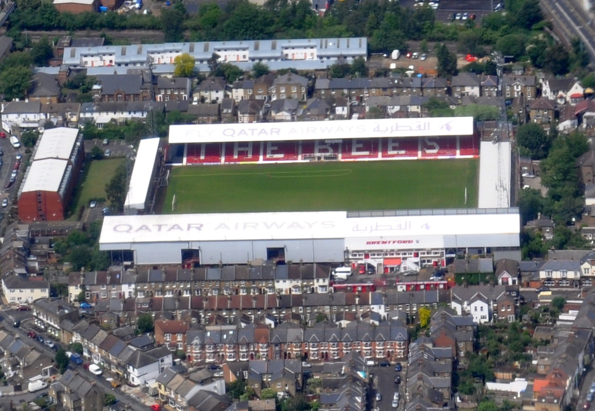
Griffin Park

Griffin Park was a football ground in Brentford in the London Borough of Hounslow, England. It was the home ground of Brentford F.C. from its opening in...
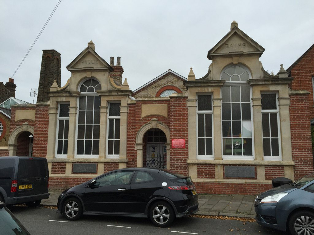
Brentford Baths

Brentford Baths is a Grade II listed building at Clifden Road, Brentford, in the London Borough of Hounslow.It was built in 1895–96, and the architect...

Brentford Library

Brentford Library is a Grade II listed building at Boston Manor Road, Brentford, London.It was built in 1903 by Joseph Dorey and Co; for the then Brentford...

Nearby Amenities

Located within 500m of 51.49319,-0.308848
Crossing
Crossing: traffic_signals
Crossing Ref: toucan
Foot: yes
Lat/Long: 51.490936/-0.3063484
Fuel
Esso
Brand: Esso
Brand Wikidata: Q867662
Check Date: 2024-02-21
Operator: Rontec
Operator Website: http://www.rontec-servicestations.co.uk/ss_results-id.cfm?id=7196
Operator Wikidata: Q107439152
Lat/Long: 51.4915445/-0.3044842
Crossing
Crossing: uncontrolled
Crossing Ref: zebra
Lat/Long: 51.4950383/-0.3055523
Traffic Signals
Lat/Long: 51.4913275/-0.3045387
Crossing
Bicycle: yes
Crossing: traffic_signals
Crossing Island: no
Crossing Ref: toucan
Foot: yes
Kerb: lowered
Tactile Paving: yes
Lat/Long: 51.4901253/-0.309054
Crossing
Crossing: traffic_signals
Crossing Ref: toucan
Foot: yes
Lat/Long: 51.491421/-0.3035275
Crossing
Button Operated: yes
Crossing: traffic_signals
Crossing Ref: toucan
Foot: yes
Tactile Paving: yes
Traffic Signals Vibration: yes
Lat/Long: 51.491248/-0.3036086
Turning Circle
Lat/Long: 51.4939002/-0.3022654
Traffic Calming: table
Lat/Long: 51.4930424/-0.3086739
Mini Roundabout
Source: bing
Lat/Long: 51.4917492/-0.3065935
Give Way
Direction: forward
Lat/Long: 51.4928059/-0.3045815
Give Way
Direction: forward
Lat/Long: 51.4926256/-0.3054536
Turning Circle
Lat/Long: 51.4918763/-0.30541
Crossing
Bicycle: yes
Crossing: traffic_signals
Crossing Ref: toucan
Foot: yes
Kerb: lowered
Tactile Paving: yes
Lat/Long: 51.4898336/-0.3088369
Crossing
Button Operated: yes
Crossing: traffic_signals
Crossing Ref: pelican
Kerb: lowered
Tactile Paving: yes
Lat/Long: 51.4936919/-0.3138262
Post Box
Brand: Royal Mail
Brand Wikidata: Q638098
Collection Times: Mo-Fr 09:00; Sa 07:00; Su off
Mapillary: 1162811454634868
Operator: Royal Mail
Operator Wikidata: Q638098
Post Box Type: pillar
Ref: W5 50
Survey Date: 2022-11-22
Lat/Long: 51.4945132/-0.3138074
Post Box
Collection Times: Mo-Fr 17:30; Sa 12:00; Su off
Mapillary: 759871491393558
Operator: Royal Mail
Operator Wikidata: Q638098
Post Box Type: pillar
Ref: W5 73
Royal Cypher: GR
Royal Cypher Wikidata: Q33102273
Survey Date: 2021-01-08
Lat/Long: 51.4962209/-0.3093417
Post Box
Brand: Royal Mail
Brand Wikidata: Q638098
Brand Wikipedia: en:Royal Mail
Collection Times: Mo-Fr 16:00; Sa 10:30
Drive Through: no
Operator: Royal Mail
Operator Wikidata: Q638098
Post Box Type: pillar
Ref: W5 49
Royal Cypher: VR
Royal Cypher Wikidata: Q33102356
Lat/Long: 51.4953741/-0.3058083
Bus Stop
Challis Road
Bus: yes
Local Ref: BX
Naptan AtcoCode: 490004966S
Naptan Bearing: N
Naptan CommonName: Challis Road
Naptan Indicator: Stop BX
Naptan Verified: no
Network: TfL
Operator: TfL
Public Transport: platform
Ref: 56331
Shelter: yes
Lat/Long: 51.4923209/-0.3044437
Bus Stop
Carlyle Road
Local Ref: G
Naptan AtcoCode: 490005978N
Naptan Bearing: N
Naptan CommonName: Darwin Road South Ealing Rd
Naptan Indicator: Stop G
Naptan Verified: no
Public Transport: platform
Ref: 71017
Lat/Long: 51.4953174/-0.3058059
Bus Stop
Darwin Road
Local Ref: F
Naptan AtcoCode: 490005978S
Naptan Bearing: N
Naptan CommonName: Darwin Road South Ealing Rd
Naptan Indicator: Stop F
Naptan Verified: no
Public Transport: platform
Ref: 75701
Wheelchair: yes
Lat/Long: 51.4946864/-0.3053399
Bus Stop
Ealing Park Gardens
Bench: no
Local Ref: E
Naptan AtcoCode: 490006294N
Naptan Bearing: N
Naptan CommonName: Ealing Park Gardens
Naptan Indicator: Stop E
Naptan Verified: no
Public Transport: platform
Shelter: no
Tactile Paving: no
Lat/Long: 51.4940298/-0.3138685
Bus Stop
Ealing Park Gardens
Bench: yes
Local Ref: D
Naptan AtcoCode: 490006294S
Naptan Bearing: S
Naptan CommonName: Ealing Park Gardens
Naptan Indicator: Stop D
Naptan Verified: no
Public Transport: platform
Shelter: yes
Tactile Paving: no
Lat/Long: 51.4942103/-0.3136808
Bus Stop
Great West Road
Bus: yes
Departures Board: no
Local Ref: BT
Naptan AtcoCode: 4900063001
Naptan Bearing: N
Naptan CommonName: Ealing Road Great West Road
Naptan Indicator: Stop BT
Naptan Verified: no
Network: TfL
Operator: TfL
Public Transport: platform
Ref: 58568
Shelter: yes
Lat/Long: 51.4907685/-0.3038631
Ealing Road
Bus: yes
Local Ref: BU
Public Transport: stop_position
Lat/Long: 51.4911549/-0.3056388
Bus Stop
Great West Road
Local Ref: BA
Naptan AtcoCode: 490006300T
Naptan Bearing: N
Naptan CommonName: Ealing Road Great West Road
Naptan Indicator: Stop BA
Naptan Verified: no
Public Transport: platform
Ref: 50450
Lat/Long: 51.4920738/-0.3042372
Ealing Road
Bus: yes
Local Ref: BB
Public Transport: stop_position
Lat/Long: 51.491245/-0.3024379
Bus Stop
Orchard Road
Bench: yes
Bin: yes
Bus: yes
Lit: yes
Local Ref: SR
Naptan AtcoCode: 490010618S1
Naptan Bearing: S
Naptan CommonName: Orchard Road Windmill Road
Naptan Indicator: SR
Naptan Street: WINDMILL ROAD
Naptan Verified: no
Public Transport: platform
Shelter: yes
Lat/Long: 51.4890323/-0.3084949
Bus Stop
Orchard Road
Bus: yes
Local Ref: SC
Naptan AtcoCode: 490010618S2
Naptan Bearing: S
Naptan CommonName: Orchard Road Windmill Road
Naptan Indicator: SC
Naptan Street: WINDMILL ROAD
Naptan Verified: no
Public Transport: platform
Lat/Long: 51.4890148/-0.3083829
Bus Stop
St Faith's Church
Bench: yes
Bin: yes
Bus: yes
Lit: yes
Naptan AtcoCode: 490012682N
Naptan Bearing: N
Naptan CommonName: St.Faiths Church
Naptan Verified: no
Public Transport: platform
Ref: 57661
Shelter: yes
Source Ref: naptan
Tactile Paving: no
Lat/Long: 51.4911227/-0.3105716
Bus Stop
St Faith's Church
Bus: yes
Naptan AtcoCode: 490012682S
Naptan Bearing: S
Naptan CommonName: St.Faiths Church
Naptan Verified: no
Public Transport: platform
Ref: 55010
Shelter: no
Source Ref: naptan
Tactile Paving: no
Lat/Long: 51.4907949/-0.3097721
Windmill Road
Bus: yes
Local Ref: BW
Public Transport: stop_position
Lat/Long: 51.4903838/-0.3073074
Windmill Road
Bus: yes
Local Ref: SB
Public Transport: stop_position
Lat/Long: 51.4899098/-0.3097368
Give Way
Direction: forward
Lat/Long: 51.4891364/-0.3119016
Car Rental
Enterprise
Addr Postcode: TW8 9JF
Brand: Enterprise
Brand Wikidata: Q17085454
Official Name: Enterprise Rent-A-Car
Lat/Long: 51.4896095/-0.3107659
Turning Circle
Lat/Long: 51.4929322/-0.3032411
Addr City: London
Addr Flats: 18;20
Addr Postcode: W5 4DN
Addr Street: Windmill Road
Entrance: yes
Lat/Long: 51.4960268/-0.3143012
Barrier: lift_gate
Lat/Long: 51.4924885/-0.3041145
Barrier: bollard
Lat/Long: 51.4910222/-0.3067723
Barrier: bollard
Lat/Long: 51.4914422/-0.3070459
Mini Roundabout
Direction: clockwise
Source: Bing
Lat/Long: 51.4902557/-0.3130456
Crossing
Crossing: uncontrolled
Crossing Island: no
Crossing Ref: zebra
Tactile Paving: yes
Lat/Long: 51.4929669/-0.3045874
Crossing
Crossing: uncontrolled
Crossing Island: no
Crossing Ref: zebra
Tactile Paving: yes
Lat/Long: 51.4971486/-0.3055639
The Co-operative Food
Check Date: 2024-02-21
Operator: The Co-operative Group
Shop: convenience
Lat/Long: 51.4916803/-0.3045665
Boston Express
Addr Housenumber: 234
Addr Street: South Ealing Road
Check Date: 2024-01-28
Shop: convenience
Source: Bing
Wheelchair: no
Lat/Long: 51.494711/-0.3056059
Monty's
Check Date: 2024-01-28
Disused Amenity: restaurant
Lat/Long: 51.4950682/-0.305756
Barrier: cycle_barrier
Lat/Long: 51.4915585/-0.3071037
Crossing
Crossing: uncontrolled
Crossing Markings: yes
Crossing Ref: zebra
Kerb: lowered
Tactile Paving: yes
Lat/Long: 51.4970049/-0.312645
Ref GB Tflcid: RWG231116
Traffic Calming: hump
Lat/Long: 51.4959469/-0.3091726
Curve Geometry: yes
Lat/Long: 51.4912926/-0.3045329
Curve Geometry: yes
Lat/Long: 51.4912154/-0.3045054
Traffic Signals
Lat/Long: 51.4913153/-0.304407
Traffic Signals
Traffic Signals Direction: backward
Lat/Long: 51.4910363/-0.3039694
Traffic Signals
Lat/Long: 51.4912646/-0.3038372
Traffic Signals
Traffic Signals Direction: backward
Lat/Long: 51.4915549/-0.304194
Traffic Signals
Lat/Long: 51.4912671/-0.303487
Traffic Signals
Lat/Long: 51.4899774/-0.3092601
Traffic Signals
Lat/Long: 51.489974/-0.3086774
Crossing
Crossing: traffic_signals
Crossing Ref: toucan
Foot: yes
Lat/Long: 51.4901481/-0.3086832
Traffic Signals
Traffic Signals Direction: backward
Lat/Long: 51.4901489/-0.3090739
Crossing
Crossing: uncontrolled
Crossing Ref: zebra
Kerb: lowered
Tactile Paving: yes
Lat/Long: 51.4905603/-0.3095406
Crossing
Crossing: traffic_signals
Crossing Ref: toucan
Foot: yes
Lat/Long: 51.4898008/-0.3091799
Traffic Signals
Traffic Signals Direction: backward
Lat/Long: 51.4898008/-0.3088153
Crossing
Crossing: traffic_signals
Crossing Ref: toucan
Foot: yes
Lat/Long: 51.4899457/-0.308754
Crossing
Crossing: traffic_signals
Crossing Ref: toucan
Foot: yes
Lat/Long: 51.4899939/-0.3092023
Crossing
Crossing: traffic_signals
Crossing Ref: toucan
Foot: yes
Tactile Paving: yes
Lat/Long: 51.4908074/-0.3062606
Crossing
Crossing: unmarked
Crossing Island: no
Lat/Long: 51.4910657/-0.3039889
Crossing
Crossing: unmarked
Lat/Long: 51.491523/-0.3041854
Post Box
Addr City: Brentford
Addr Housenumber: 47
Addr Street: Enfield Road
Collection Times: Mo-Sa 07:30
Operator: Royal Mail
Operator Wikidata: Q638098
Ref: TW8 218
Lat/Long: 51.4922038/-0.3082138
Childcare
Busy Bees
Operator: HappyChild
Lat/Long: 51.4968468/-0.3130199
Crossing
Bicycle: yes
Crossing: uncontrolled
Crossing Island: no
Crossing Ref: tiger
Kerb: flush
Tactile Paving: no
Lat/Long: 51.4974599/-0.310346
Telephone
Booth: KX100
Covered: booth
Lat/Long: 51.4950084/-0.3054035
Post Box
Brand: Royal Mail
Brand Wikidata: Q638098
Brand Wikipedia: en:Royal Mail
Collection Times: Mo-Fr 09:00; Sa 07:00
Drive Through: no
Mapillary: 1624795767933304
Operator: Royal Mail
Operator Wikidata: Q638098
Post Box Type: pillar
Ref: TW8 201
Survey Date: 2023-03-16
Lat/Long: 51.4928036/-0.3047861
Post Box
Brand: Royal Mail
Brand Wikidata: Q638098
Mapillary: 956320771811168
Operator: Royal Mail
Operator Wikidata: Q638098
Post Box Type: pillar
Ref: TW8 207
Survey Date: 2021-01-08
Lat/Long: 51.4917282/-0.3113495
Post Box
Brand: Royal Mail
Brand Wikidata: Q638098
Mapillary: 675708143938885
Operator: Royal Mail
Operator Wikidata: Q638098
Post Box Type: pillar
Ref: TW8 220
Survey Date: 2022-11-22
Lat/Long: 51.4904389/-0.3092802
Bus Stop
Windmill Road
Bus: yes
Local Ref: SB
Naptan AtcoCode: 490014772Q
Naptan Bearing: E
Naptan CommonName: Windmill Road Great West Rd
Naptan Indicator: Stop SB
Naptan Verified: no
Public Transport: platform
Ref: 49111
Lat/Long: 51.4899455/-0.3097291
Bus Stop
Windmill Road
Lit: yes
Local Ref: BW
Naptan AtcoCode: 4900147722
Naptan Bearing: W
Naptan CommonName: Windmill Road Great West Rd
Naptan Indicator: Stop BW
Naptan Street: GREAT WEST ROAD
Naptan Verified: no
Public Transport: platform
Ref: 57702
Shelter: yes
Lat/Long: 51.4903454/-0.3072686
Bus Stop
Ealing Road
Local Ref: BU
Naptan AtcoCode: 490006300R
Naptan Bearing: E
Naptan CommonName: Ealing Road Great West Road
Naptan Indicator: BU
Naptan Street: GREAT WEST ROAD
Naptan Verified: no
Public Transport: platform
Ref: 55030
Lat/Long: 51.4911758/-0.3056549
Bus Stop
Ealing Road
Bench: yes
Bin: yes
Bus: yes
Lit: yes
Local Ref: BB
Naptan AtcoCode: 490006300W
Naptan Bearing: W
Naptan CommonName: Ealing Road Great West Road
Naptan Indicator: Stop BB
Naptan Street: GREAT WEST ROAD
Naptan Verified: no
Public Transport: platform
Ref: 73401
Shelter: yes
Tactile Paving: no
Lat/Long: 51.4911771/-0.3024325
Phone
Emergency: phone
Layer: 1
Lat/Long: 51.4910591/-0.3060348
Phone
Emergency: phone
Layer: 1
Lat/Long: 51.4908908/-0.3059693
Street Lamp
Lamp Model: Thorn Civic 2
Lamp Type: SON
Layer: 1
Source: Local knowledge
Lat/Long: 51.49137/-0.3024
Street Lamp
Lamp Model: Thorn Civic 2
Lamp Type: SON
Layer: 1
Source: Local knowledge
Lat/Long: 51.491178/-0.3050033
Street Lamp
Lamp Model: Thorn Civic 2
Lamp Type: SON
Layer: 1
Source: Local knowledge
Lat/Long: 51.4912595/-0.3045148
Street Lamp
Lamp Model: Thorn Civic 2
Lamp Type: SON
Layer: 1
Source: Local knowledge
Lat/Long: 51.4913143/-0.3040086
Street Lamp
Lamp Model: Thorn Civic 2
Lamp Type: SON
Layer: 1
Source: Local knowledge
Lat/Long: 51.4913528/-0.3034627
Street Lamp
Lamp Model: Thorn Civic 2
Lamp Type: SON
Layer: 1
Source: Local knowledge
Lat/Long: 51.4913666/-0.3029239
Street Lamp
Lamp Model: Thorn Civic 2
Lamp Type: SON
Layer: 1
Source: Local knowledge
Lat/Long: 51.4910879/-0.3054781
Street Lamp
Lamp Model: Thorn Civic 2
Lamp Type: SON
Layer: 1
Source: Local knowledge
Lat/Long: 51.4908042/-0.3064769
Street Lamp
Lamp Model: Philips SGS253
Lamp Type: SON
Layer: 1
Source: Local knowledge
Lat/Long: 51.4908433/-0.3065069
Street Lamp
Lamp Model: Thorn Civic 2
Lamp Type: SON
Layer: 1
Source: Local knowledge
Lat/Long: 51.4909758/-0.3059857
Street Lamp
Lamp Model: Thorn Civic 2
Lamp Type: SON
Layer: 1
Source: Local knowledge
Lat/Long: 51.4906768/-0.3069298
Street Lamp
Lamp Model: Thorn Civic 2
Lamp Type: SON
Layer: 1
Source: Local knowledge
Lat/Long: 51.4905119/-0.3073992
Street Lamp
Lamp Model: Thorn Civic 2
Lamp Type: SON
Layer: 1
Source: Local knowledge
Lat/Long: 51.490342/-0.3078604
Street Lamp
Lamp Model: Thorn Civic 2
Lamp Type: SON
Layer: 1
Source: Local knowledge
Lat/Long: 51.4901551/-0.3083898
Street Lamp
Lamp Model: Thorn Civic 2
Lamp Type: SON
Layer: 1
Source: Local knowledge
Lat/Long: 51.4898612/-0.3092712
Street Lamp
Lamp Model: Thorn Civic 2
Lamp Type: SON
Layer: 1
Source: Local knowledge
Lat/Long: 51.4900056/-0.3088127
Street Lamp
Lamp Model: Thorn Civic 2
Lamp Type: SON
Layer: 1
Source: Local knowledge
Lat/Long: 51.4897272/-0.3097219
Street Lamp
Lamp Model: Thorn Civic 2
Lamp Type: SON
Layer: 1
Source: Local knowledge
Lat/Long: 51.4895841/-0.3102152
Street Lamp
Lamp Model: Thorn Civic 2
Lamp Type: SON
Layer: 1
Source: Local knowledge
Lat/Long: 51.4894755/-0.3107034
Street Lamp
Lamp Model: Thorn Civic 2
Lamp Type: SON
Layer: 1
Source: Local knowledge
Lat/Long: 51.4893872/-0.311225
Phone
Emergency: phone
Layer: 1
Lat/Long: 51.4894656/-0.311285
Phone
Emergency: phone
Layer: 1
Lat/Long: 51.4892874/-0.3112189
Street Lamp
Lamp Model: Thorn Civic 2
Lamp Type: SON
Layer: 1
Source: Local knowledge
Lat/Long: 51.4893058/-0.3117457
Street Lamp
Lamp Model: Thorn Civic 2
Lamp Type: SON
Layer: 1
Source: Local knowledge
Lat/Long: 51.4892524/-0.3122624
Street Lamp
Lamp Model: CU Phosco P850
Lamp Type: LED
Light Count: 1
Ref: 343
Source: Personal memory
Lat/Long: 51.4890887/-0.3117317
Street Lamp
Lamp Model: CU Phosco P850
Lamp Type: LED
Light Count: 1
Ref: 345
Source: Personal memory
Lat/Long: 51.4891817/-0.3115005
Give Way
Lat/Long: 51.4974792/-0.310179
Toolstation
Brand: Toolstation
Brand Wikidata: Q7824103
Contact Website: https://www.toolstation.com/branches/brentford
Shop: doityourself
Lat/Long: 51.4918269/-0.3034819
Screwfix
Brand: Screwfix
Brand Wikidata: Q7439115
Shop: doityourself
Website: https://www.screwfix.com/stores/IT3/brentford
Lat/Long: 51.491812/-0.3037887
Topps Tiles
Shop: doityourself
Lat/Long: 51.4918071/-0.3039913
Kwik Fit
Brand: Kwik Fit
Brand Wikidata: Q958053
Shop: car_repair
Lat/Long: 51.4918754/-0.3030807
Crown Decorating Centre
Shop: doityourself
Lat/Long: 51.4918239/-0.3036546
UK1 Championship
Leisure: sports_centre
Sport: martial_arts
Lat/Long: 51.4967857/-0.3124897
Bicycle Parking
Access: yes
Bicycle Parking: stands
Capacity: 6
Covered: no
Mapillary: 165763362159916
Operator Type: public
Survey Date: 2021-03-24
Lat/Long: 51.4968174/-0.3123983
Blue Lion Estates
Office: estate_agent
Lat/Long: 51.4968955/-0.3127839
Cloud Club
Shop: e-cigarette
Lat/Long: 51.4968219/-0.3125772
Aqua Bathrooms
Shop: interior_decoration
Lat/Long: 51.4969015/-0.3128361
O'Dwyer Independent Funeral Directors
Shop: funeral_directors
Lat/Long: 51.4968745/-0.3127154
Divine Revelation
Check Date: 2023-07-15
Shop: beauty
Lat/Long: 51.4967676/-0.3123715
Childcare
Monkey Puzzle
Check Date: 2024-04-27
Nursery: yes
Phone: +44 20 8840 1116
Lat/Long: 51.497341/-0.3102538
Traffic Calming: table
Lat/Long: 51.4968676/-0.3118216
Bicycle Parking
Access: yes
Bicycle Parking: stands
Capacity: 2
Covered: no
Operator Type: public
Lat/Long: 51.4971055/-0.305644
Bicycle Parking
Access: yes
Bicycle Parking: stands
Capacity: 4
Covered: no
Operator Type: public
Lat/Long: 51.4971874/-0.3056573
Access: no
Barrier: block
Bicycle: yes
Foot: yes
Horse: yes
Material: concrete
Motor Vehicle: no
Lat/Long: 51.4961814/-0.3056662
Traffic Calming: hump
Lat/Long: 51.4966166/-0.3098006
Traffic Calming: table
Lat/Long: 51.4970179/-0.3056428
Traffic Calming: hump
Lat/Long: 51.4970344/-0.3101913
Generator Method: photovoltaic
Generator Output Electricity: yes
Generator Source: solar
Generator Type: solar_photovoltaic_panel
Location: roof
Power: generator
Lat/Long: 51.4903312/-0.3038608
Generator Method: photovoltaic
Generator Source: solar
Generator Type: solar_photovoltaic_panel
Location: roof
Power: generator
Lat/Long: 51.4903124/-0.3039224
Generator Method: photovoltaic
Generator Source: solar
Generator Type: solar_photovoltaic_panel
Location: roof
Power: generator
Lat/Long: 51.4903011/-0.3039882
Generator Method: photovoltaic
Generator Source: solar
Generator Type: solar_photovoltaic_panel
Location: roof
Power: generator
Lat/Long: 51.4902827/-0.3040847
Generator Method: photovoltaic
Generator Source: solar
Generator Type: solar_photovoltaic_panel
Location: roof
Power: generator
Lat/Long: 51.4902698/-0.3041424
Generator Method: photovoltaic
Generator Source: solar
Generator Type: solar_photovoltaic_panel
Location: roof
Power: generator
Lat/Long: 51.4902163/-0.3042416
Generator Method: photovoltaic
Generator Source: solar
Generator Type: solar_photovoltaic_panel
Location: roof
Power: generator
Lat/Long: 51.4901984/-0.3042993
Generator Method: photovoltaic
Generator Source: solar
Generator Type: solar_photovoltaic_panel
Location: roof
Power: generator
Lat/Long: 51.4901963/-0.3043449
Generator Method: photovoltaic
Generator Source: solar
Generator Type: solar_photovoltaic_panel
Location: roof
Power: generator
Lat/Long: 51.4901763/-0.3043945
Generator Method: photovoltaic
Generator Source: solar
Generator Type: solar_photovoltaic_panel
Location: roof
Power: generator
Lat/Long: 51.4901642/-0.3044656
Generator Method: photovoltaic
Generator Source: solar
Generator Type: solar_photovoltaic_panel
Location: roof
Power: generator
Lat/Long: 51.4901512/-0.3045917
Generator Method: photovoltaic
Generator Source: solar
Generator Type: solar_photovoltaic_panel
Location: roof
Power: generator
Lat/Long: 51.4901391/-0.3046332
Generator Method: photovoltaic
Generator Source: solar
Generator Type: solar_photovoltaic_panel
Location: roof
Power: generator
Lat/Long: 51.4900999/-0.3047251
Generator Method: photovoltaic
Generator Source: solar
Generator Type: solar_photovoltaic_panel
Location: roof
Power: generator
Lat/Long: 51.4900777/-0.3047928
Generator Method: photovoltaic
Generator Source: solar
Generator Type: solar_photovoltaic_panel
Location: roof
Power: generator
Lat/Long: 51.4900681/-0.3048398
Generator Method: photovoltaic
Generator Source: solar
Generator Type: solar_photovoltaic_panel
Location: roof
Power: generator
Lat/Long: 51.4900552/-0.304888
Generator Method: photovoltaic
Generator Source: solar
Generator Type: solar_photovoltaic_panel
Location: roof
Power: generator
Lat/Long: 51.4900402/-0.3049437
Generator Method: photovoltaic
Generator Source: solar
Generator Type: solar_photovoltaic_panel
Location: roof
Power: generator
Lat/Long: 51.4900301/-0.3050704
Generator Method: photovoltaic
Generator Source: solar
Generator Type: solar_photovoltaic_panel
Location: roof
Power: generator
Lat/Long: 51.4900176/-0.3051254
Generator Method: photovoltaic
Generator Source: solar
Generator Type: solar_photovoltaic_panel
Location: roof
Power: generator
Lat/Long: 51.4899771/-0.3052166
Generator Method: photovoltaic
Generator Source: solar
Generator Type: solar_photovoltaic_panel
Location: roof
Power: generator
Lat/Long: 51.48996/-0.3052803
Generator Method: photovoltaic
Generator Source: solar
Generator Type: solar_photovoltaic_panel
Location: roof
Power: generator
Lat/Long: 51.4899429/-0.3053373
Generator Method: photovoltaic
Generator Source: solar
Generator Type: solar_photovoltaic_panel
Location: roof
Power: generator
Lat/Long: 51.4899283/-0.3053836
Generator Method: photovoltaic
Generator Source: solar
Generator Type: solar_photovoltaic_panel
Location: roof
Power: generator
Lat/Long: 51.4899157/-0.3054399
Generator Method: photovoltaic
Generator Source: solar
Generator Type: solar_photovoltaic_panel
Location: roof
Power: generator
Lat/Long: 51.4897617/-0.305686
Generator Method: photovoltaic
Generator Source: solar
Generator Type: solar_photovoltaic_panel
Location: roof
Power: generator
Lat/Long: 51.4898013/-0.3057095
Generator Method: photovoltaic
Generator Source: solar
Generator Type: solar_photovoltaic_panel
Location: roof
Power: generator
Lat/Long: 51.4898489/-0.3057437
Generator Method: photovoltaic
Generator Source: solar
Generator Type: solar_photovoltaic_panel
Location: roof
Power: generator
Lat/Long: 51.489884/-0.3057577
Generator Method: photovoltaic
Generator Source: solar
Generator Type: solar_photovoltaic_panel
Location: roof
Power: generator
Lat/Long: 51.4899329/-0.3057946
Bicycle Parking
Access: private
Bicycle Parking: shed
Capacity: 6
Covered: yes
Operator: cyclehoop
Ref: Bikehangar 1094
Lat/Long: 51.4907979/-0.3096664
Barrier: block
Traffic Intervention: modal_filter
Lat/Long: 51.4917389/-0.3066043
Barrier: planter
Bicycle: yes
Foot: yes
Traffic Intervention: modal_filter
Lat/Long: 51.4934768/-0.3075605
Direction: 165
Generator Method: photovoltaic
Generator Output Electricity: yes
Generator Solar Modules: 6
Generator Source: solar
Generator Type: solar_photovoltaic_panel
Location: roof
Power: generator
Lat/Long: 51.4947429/-0.3080527
Direction: 165
Generator Method: photovoltaic
Generator Output Electricity: yes
Generator Solar Modules: 6
Generator Source: solar
Generator Type: solar_photovoltaic_panel
Location: roof
Power: generator
Lat/Long: 51.4947589/-0.3079828
Direction: 80
Generator Method: photovoltaic
Generator Output Electricity: yes
Generator Source: solar
Generator Type: solar_photovoltaic_panel
Location: roof
Power: generator
Lat/Long: 51.4976795/-0.3084525
Direction: 165
Generator Method: photovoltaic
Generator Output Electricity: yes
Generator Solar Modules: 24
Generator Source: solar
Generator Type: solar_photovoltaic_panel
Location: roof
Power: generator
Lat/Long: 51.4947823/-0.3080571
Direction: 165
Generator Method: photovoltaic
Generator Output Electricity: yes
Generator Solar Modules: 4
Generator Source: solar
Generator Type: solar_photovoltaic_panel
Location: roof
Power: generator
Lat/Long: 51.49474/-0.308116
Bicycle Parking
Access: private
Bicycle Parking: shed
Capacity: 6
Covered: yes
Operator: cyclehoop
Ref: Bikehangar 742
Lat/Long: 51.4901859/-0.3063673
Childcare
The Little School
Lat/Long: 51.4900531/-0.3113884
Power: transformer
Lat/Long: 51.4912205/-0.3067461
Power: transformer
Lat/Long: 51.491162/-0.3067086
Power: transformer
Lat/Long: 51.4912309/-0.3062928
Power: transformer
Lat/Long: 51.4913094/-0.3063445
Post Box
Brand: Royal Mail
Brand Wikidata: Q638098
Brand Wikipedia: en:Royal Mail
Collection Times: Mo-Fr 09:00; Sa 07:00
Operator: Royal Mail
Operator Wikidata: Q638098
Post Box Type: wall
Ref: TW8 208D
Royal Cypher: GR
Royal Cypher Wikidata: Q33102273
Lat/Long: 51.4901489/-0.3063915
Bicycle Parking
Access: private
Bicycle Parking: shed
Capacity: 6
Covered: yes
Operator: cyclehoop
Ref: Bikehangar 2293
Lat/Long: 51.4902081/-0.3063846
Bicycle Parking
Access: private
Bicycle Parking: shed
Capacity: 6
Operator: cyclehoop
Ref: Bikehangar 1030
Lat/Long: 51.495403/-0.3087531
Barrier: height_restrictor
Lat/Long: 51.488759/-0.3086229
Traffic Calming: hump
Lat/Long: 51.4952291/-0.3086974
Direction: WSW
Generator Method: photovoltaic
Generator Output Electricity: yes
Generator Solar Modules: 120
Generator Source: solar
Generator Type: solar_photovoltaic_panel
Location: roof
Power: generator
Lat/Long: 51.4960337/-0.3116727
Direction: WSW
Generator Method: photovoltaic
Generator Output Electricity: yes
Generator Solar Modules: 52
Generator Source: solar
Generator Type: solar_photovoltaic_panel
Location: roof
Power: generator
Lat/Long: 51.4959435/-0.3118417
Direction: WSW
Generator Method: photovoltaic
Generator Output Electricity: yes
Generator Solar Modules: 26
Generator Source: solar
Generator Type: solar_photovoltaic_panel
Location: roof
Power: generator
Lat/Long: 51.4958775/-0.3118873
Direction: WSW
Generator Method: photovoltaic
Generator Output Electricity: yes
Generator Solar Modules: 96
Generator Source: solar
Generator Type: solar_photovoltaic_panel
Location: roof
Power: generator
Lat/Long: 51.4959485/-0.3123231
Direction: WSW
Generator Method: photovoltaic
Generator Output Electricity: yes
Generator Solar Modules: 66
Generator Source: solar
Generator Type: solar_photovoltaic_panel
Location: roof
Power: generator
Lat/Long: 51.4959026/-0.3122192
Direction: WSW
Generator Method: photovoltaic
Generator Output Electricity: yes
Generator Solar Modules: 86
Generator Source: solar
Generator Type: solar_photovoltaic_panel
Location: roof
Power: generator
Lat/Long: 51.4956863/-0.3121857
Direction: WSW
Generator Method: photovoltaic
Generator Output Electricity: yes
Generator Solar Modules: 46
Generator Source: solar
Generator Type: solar_photovoltaic_panel
Location: roof
Power: generator
Lat/Long: 51.4956467/-0.3123111
Dentist
Banning Dental Group
Addr City: London
Addr Housename: Vale Court
Addr Postcode: TW8 0LN
Addr Street: Ealing Road
Healthcare: dentist
Healthcare Speciality: dentist
Opening Hours: Mo,We 09:00-20:00; Tu,Th-Sa 09:00-17:00
Payment Contactless: yes
Phone: +44 20 80175 869
Website: https://banningdental.co.uk
Lat/Long: 51.490598/-0.3038364
Diva
Addr Floor: G
Addr Housenumber: 188
Addr Street: South Ealing Road
Check Date: 2024-01-23
Level: 0
Phone: +44 20 8568 2220
Shop: beauty
Lat/Long: 51.4972472/-0.3057504
Bill Bunn Motorcycles
Shop: motorcycle
Lat/Long: 51.4970853/-0.3057343
Restaurant
Starvin marvin
Addr Floor: G
Addr Housenumber: 190
Addr Street: South Ealing Road
Check Date: 2024-01-23
Cuisine: croatian
Level: 0
Opening Hours: We-Su 17:00-01:00
Phone: +44 20 8143 1762
Lat/Long: 51.4972021/-0.3057241
Generator Method: photovoltaic
Generator Solar Modules: 10
Generator Source: solar
Generator Type: solar_photovoltaic_panel
Power: generator
Lat/Long: 51.4952234/-0.3099956
Access: private
Addr City: London
Addr Flats: 9-16
Addr Postcode: W5 4DW
Addr Street: Windmill Road
Entrance: yes
Lat/Long: 51.4966378/-0.3134847
Addr Flats: 14,16
Entrance: yes
Lat/Long: 51.4958897/-0.3144599
Addr Flats: 15
Entrance: yes
Lat/Long: 51.4958499/-0.3144101
Addr City: London
Addr Flats: 17
Addr Postcode: W5 4DN
Addr Street: Windmill Road
Entrance: yes
Lat/Long: 51.4960013/-0.3142691
Addr City: London
Addr Flats: 19
Addr Postcode: W5 4DN
Addr Street: Windmill Road
Entrance: yes
Lat/Long: 51.4960541/-0.3143355
Addr Flats: 13
Entrance: yes
Lat/Long: 51.4959346/-0.3145161
Addr City: London
Addr Flats: 27
Addr Postcode: W5 4DN
Addr Street: Windmill Road
Entrance: yes
Lat/Long: 51.4963502/-0.3139934
Addr City: London
Addr Flats: 29
Addr Postcode: W5 4DN
Addr Street: Windmill Road
Entrance: yes
Lat/Long: 51.4963736/-0.3139546
Addr City: London
Addr Flats: 30;32
Addr Postcode: W5 4DN
Addr Street: Windmill Road
Entrance: yes
Lat/Long: 51.4964012/-0.313909
Addr City: London
Addr Flats: 31
Addr Postcode: W5 4DN
Addr Street: Windmill Road
Entrance: yes
Lat/Long: 51.4964291/-0.3138592
Access: private
Addr City: London
Addr Flats: 17-24
Addr Postcode: W5 4DW
Addr Street: Windmill Road
Entrance: yes
Lat/Long: 51.4965287/-0.3136932
Access: private
Addr City: London
Addr Flats: 1-8
Addr Postcode: W5 4DW
Addr Street: Windmill Road
Entrance: yes
Lat/Long: 51.4967494/-0.3132693
Generator Method: photovoltaic
Generator Solar Modules: 6
Generator Source: solar
Generator Type: solar_photovoltaic_panel
Power: generator
Lat/Long: 51.4952088/-0.3143878
Generator Method: photovoltaic
Generator Solar Modules: 10
Generator Source: solar
Generator Type: solar_photovoltaic_panel
Power: generator
Lat/Long: 51.4952248/-0.3099976
Addr Flats: 1-8
Addr Street: Ashmount Terrace
Entrance: yes
Lat/Long: 51.4952039/-0.3057606
Addr City: London
Addr Housenumber: 109
Addr Postcode: W5 4DJ
Addr Street: Windmill Road
Lat/Long: 51.4908286/-0.3095316
Addr City: London
Addr Housenumber: 139
Addr Postcode: W5 4DJ
Addr Street: Windmill Road
Lat/Long: 51.4917565/-0.3111769
Brentford Tyres
Car Parts: tyres
Check Date: 2024-01-28
Shop: car_parts
Lat/Long: 51.494908/-0.3056751
Day To Day Food and Wine
Addr Floor: G
Check Date: 2024-01-28
Level: 0
Shop: convenience
Lat/Long: 51.4950239/-0.3057283
Parcel Locker
Brand: Inpost
Lat/Long: 51.4947614/-0.3056102
RentSource Real Estate
Check Date: 2024-01-28
Office: estate_agent
Lat/Long: 51.4949879/-0.3057161
Addr Flats: 59a
Entrance: yes
Lat/Long: 51.4954065/-0.3089094
Noexit: yes
Lat/Long: 51.4933693/-0.3156015
Turning Circle
Lat/Long: 51.4913494/-0.3153377
Traffic Calming: table
Lat/Long: 51.4910297/-0.3084902
Give Way
Direction: forward
Lat/Long: 51.4922853/-0.3081741
Traffic Calming: table
Lat/Long: 51.490695/-0.3089028
Traffic Calming: table
Lat/Long: 51.4915452/-0.3069486
Traffic Calming: table
Lat/Long: 51.4910967/-0.3079709
Crossing
Traffic Calming: table
Lat/Long: 51.4917802/-0.3114282
Traffic Calming: table
Lat/Long: 51.4922095/-0.3104914
Traffic Calming: table
Lat/Long: 51.4926099/-0.3096177
Traffic Calming: table
Lat/Long: 51.493185/-0.3076806
Traffic Calming: table
Lat/Long: 51.4928022/-0.3079059
Traffic Calming: table
Lat/Long: 51.4919351/-0.3082216
Traffic Calming: table
Lat/Long: 51.4913413/-0.308397
Noexit: yes
Lat/Long: 51.4906648/-0.3087739
Noexit: yes
Lat/Long: 51.4929078/-0.3120593
Addr Housenumber: 43
Addr Postcode: TW8 0QQ
Addr Street: Windmill Road
Lat/Long: 51.4889801/-0.3082864
Addr Housenumber: 67
Addr Postcode: TW8 0QQ
Addr Street: Windmill Road
Lat/Long: 51.4894502/-0.3084379
Proposed Amenity: charging_station
Source: https://www.thegazette.co.uk/notice/4122290
Lat/Long: 51.4927753/-0.310914
Proposed Amenity: charging_station
Source: https://www.thegazette.co.uk/notice/4122290
Lat/Long: 51.4938041/-0.3089307
Ref GB Tflcid: RWG229977
Traffic Calming: hump
Lat/Long: 51.4892684/-0.3095916
Ref GB Tflcid: RWG231118
Traffic Calming: hump
Lat/Long: 51.4945282/-0.308226
Ref GB Tflcid: RWG231302
Traffic Calming: hump
Lat/Long: 51.4938627/-0.3063525
Ref GB Tflcid: RWG229335
Traffic Calming: cushion
Lat/Long: 51.4934519/-0.3030326
Ref GB Tflcid: RWG229336
Traffic Calming: cushion
Lat/Long: 51.4935209/-0.3019825
Bicycle Parking
Access: yes
Bicycle Parking: stands
Capacity: 4
Covered: no
Fee: no
Ref GB Tflcid: RWG232577
Lat/Long: 51.4893402/-0.3054953
Bicycle Parking
Bicycle Parking: stands
Capacity: 6
Ref GB Tflcid: RWG233367
Lat/Long: 51.4913/-0.3053318
Bicycle Parking
Bicycle Parking: stands
Capacity: 4
Ref GB Tflcid: RWG233370
Lat/Long: 51.4904745/-0.3095992
Bicycle Parking
Bicycle Parking: stands
Capacity: 4
Ref GB Tflcid: RWG232521
Lat/Long: 51.4889931/-0.3083834
Addr Housenumber: 12
Addr Postcode: TW8 9PZ
Addr Street: Cherry Garth
Entrance: yes
Lat/Long: 51.4930617/-0.3031967
Addr Flats: 8-11
Addr Postcode: TW8 9PZ
Addr Street: Cherry Garth
Entrance: yes
Lat/Long: 51.4929685/-0.3031632
Addr Housenumber: 7
Addr Postcode: TW8 9PZ
Addr Street: Cherry Garth
Entrance: yes
Lat/Long: 51.4928695/-0.3030962
Addr Housenumber: 6
Addr Postcode: TW8 9PZ
Addr Street: Cherry Garth
Entrance: yes
Lat/Long: 51.4928172/-0.3033808
Addr Housenumber: 1
Addr Postcode: TW8 9PZ
Addr Street: Cherry Garth
Entrance: yes
Lat/Long: 51.4929702/-0.3034468
Addr Flats: 2-5
Addr Postcode: TW8 9PZ
Addr Street: Cherry Garth
Entrance: yes
Lat/Long: 51.4929124/-0.3034168
Entrance: yes
Lat/Long: 51.4968119/-0.3130574
Curve Geometry: yes
Lat/Long: 51.4894829/-0.3105168
Curve Geometry: yes
Lat/Long: 51.4895565/-0.3105547
Bicycle Parking
Access: private
Bicycle Parking: shed
Capacity: 6
Covered: yes
Operator: cyclehoop
Ref: Bikehangar 3982
Lat/Long: 51.4923548/-0.3118995
Bicycle Parking
Access: private
Bicycle Parking: shed
Capacity: 6
Covered: yes
Operator: cyclehoop
Ref: Bikehangar 3983
Lat/Long: 51.4933457/-0.3097251
Bicycle Parking
Bicycle Parking: stands
Capacity: 6
Covered: no
Mapillary: 165763362159916
Survey Date: 2021-03-24
Lat/Long: 51.4968713/-0.312566
Childcare
Fennies Day Nursery
Nursery: yes
Lat/Long: 51.4945207/-0.3083764
Charging Station
Brand: Believ
Fee: yes
Level: 0
Ref: GB-LCL-A0383
Lat/Long: 51.4954054/-0.3088723
Barrier: bollard
Bicycle: no
Bollard: fixed
Foot: yes
Motor Vehicle: no
Lat/Long: 51.4917014/-0.3082111
Living Bathrooms
Addr Floor: G
Check Date: 2023-12-29
Level: 0
Shop: bathroom_furnishing
Wheelchair: no
Lat/Long: 51.4906664/-0.3094103
Restaurant
Pizzaolo
Check Date: 2023-12-29
Cuisine: pizza
Takeaway: only
Lat/Long: 51.4889644/-0.3083036
Crossing
Crossing: uncontrolled
Crossing Island: no
Crossing Markings: zebra
Crossing Ref: zebra
Kerb: lowered
Tactile Paving: yes
Lat/Long: 51.4904792/-0.3035046
Bicycle Parking
Bicycle Parking: stands
Capacity: 4
Covered: no
Lat/Long: 51.4962079/-0.3092526
Traffic Calming: hump
Lat/Long: 51.4938653/-0.307785
Bicycle Parking
Access: yes
Bicycle Parking: stands
Capacity: 2
Covered: no
Operator Type: public
Lat/Long: 51.4954713/-0.3058624
Communication Mobile Phone: yes
Man Made: mast
Tower Construction: freestanding
Tower Type: communication
Lat/Long: 51.4955772/-0.3056652
Charging Station
Access: customers
Capacity: 4
Fee: yes
Lat/Long: 51.4969821/-0.3056897
Bicycle Parking
Access: yes
Bicycle Parking: stands
Capacity: 2
Covered: no
Operator Type: public
Lat/Long: 51.4970261/-0.3054921
Access: no
Barrier: planter
Bicycle: yes
Foot: yes
Horse: yes
Material: concrete
Motor Vehicle: no
Traffic Intervention: modal_filter
Lat/Long: 51.4961442/-0.3056261
Addr Housenumber: 84
Addr Street: Enfield Road
Building: yes
Lat/Long: 51.4933249/-0.3074947
Bicycle Parking
Access: yes
Bicycle Parking: stands
Capacity: 2
Covered: no
Operator Type: public
Lat/Long: 51.4973636/-0.3107384
The data included in this document is from www.openstreetmap.org. The data is made available under ODbL.

Have you been to Ealing, Little?

Leave your review of Ealing, Little below (or comments, questions and feedback).