Little Ross

Island in Kirkcudbrightshire

Scotland

Little Ross

Slipway on Little Ross Slipway on Little Ross Island, with strikingly stratified rock. White pillar in the background is one of the leading marks.
Slipway on Little Ross Credit: Simon Brooke

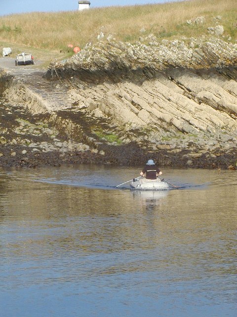
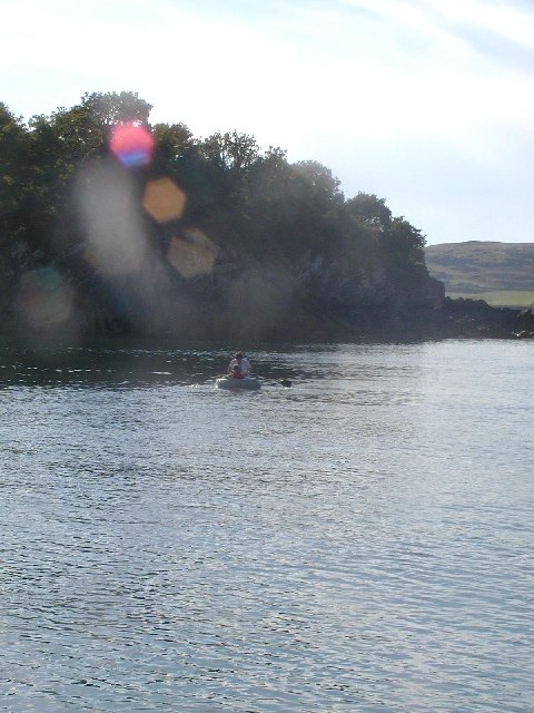
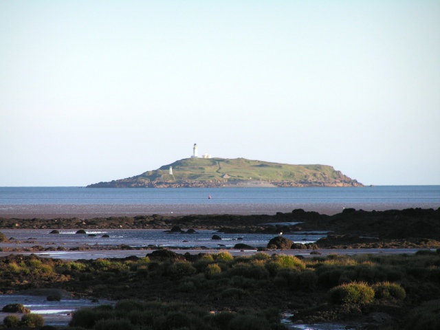
Little Ross is a small uninhabited island located off the coast of Kirkcudbrightshire in southwest Scotland. The island, measuring roughly 29 acres, is situated in the Solway Firth, about 200 meters from the mainland. It is reachable by a short boat ride from the village of Kirkcudbright.

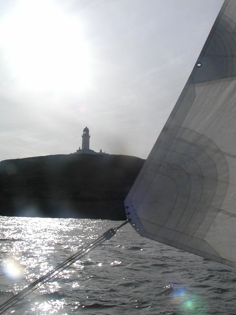
The island is known for its rugged and picturesque landscape, with cliffs and rocky shores surrounding most of its perimeter. It is also home to a historic lighthouse, which was built in 1843 and is now a listed building. The lighthouse, standing at 20 meters tall, played a crucial role in guiding ships through the treacherous waters of the Solway Firth for over a century.

Little Ross has no permanent residents, but it attracts visitors who come to explore its natural beauty and historical significance. The island offers opportunities for hiking and birdwatching, with various species of seabirds, including puffins, gannets, and fulmars, nesting there during the breeding season.

In 1960, the island gained notoriety when a murder took place on its grounds. The lighthouse keeper, Robert Dickson, was killed by a fellow keeper, resulting in a sensational trial. Despite this dark past, Little Ross remains a peaceful and idyllic destination for those seeking solitude and a glimpse into the region's maritime history.

If you have any feedback on the listing, please let us know in the comments section below.

Little Ross Images

Images are sourced within 2km of 54.766446/-4.0854489 or Grid Reference NX6543. Thanks to Geograph Open Source API. All images are credited.

Slipway on Little Ross Slipway on Little Ross Island, with strikingly stratified rock. White pillar in the background is one of the leading marks.
Slipway on Little Ross
Slipway on Little Ross Island, with strikingly stratified rock. White pillar in the background is one of the leading marks.
Manor Hole Manor hole, in Ross Bay, is one of the few reasonable sheltered all-tide anchorages on the Solway.
Manor Hole
Manor hole, in Ross Bay, is one of the few reasonable sheltered all-tide anchorages on the Solway.
Scrapyard, Ross Bay At least, it looks like a scrapyard, but it may just be untidy...
Scrapyard, Ross Bay
At least, it looks like a scrapyard, but it may just be untidy...
Ross Island Light The lighthouse on Ross Island was built by Robert Louis Stevenson's grandfather. It was manned until the August 1960, when one of the two lighthouse keepers murdered the other for a small sum in football pools winnings. The light is now automatic, but the house is once again occupied.
Ross Island Light
The lighthouse on Ross Island was built by Robert Louis Stevenson's grandfather. It was manned until the August 1960, when one of the two lighthouse keepers murdered the other for a small sum in football pools winnings. The light is now automatic, but the house is once again occupied.
Little Ross As seen from St Mary's Isle
Little Ross
As seen from St Mary's Isle
Bay Houses on south side of  Ross Bay
Bay Houses on south side of Ross Bay
Ross Farm, Borgue.
Ross Farm, Borgue.
Little Ross island and Meikle Ross hill Taken from Torrs Point
Little Ross island and Meikle Ross hill
Taken from Torrs Point
Tiny Beach between Bar Point and Shaw hole
Ross Bay from near Blackstone Cottage
Looking out from the south side of Ross Bay to Kirkcudbright Bay
Little Ross Island Looking out from the mainland to Little Ross in Kirkcudbright Bay
Little Ross Island
Looking out from the mainland to Little Ross in Kirkcudbright Bay
Old harbour side at Ross Bay
Not for a while
Not for a while
Old Jetty Stakes for jetty can be seen along with an old boat
Old Jetty
Stakes for jetty can be seen along with an old boat
Derelict house, Ross Farm Some parts of the steading have been renovated, this bit is just waiting it's turn.
Derelict house, Ross Farm
Some parts of the steading have been renovated, this bit is just waiting it's turn.
Lots of warnings Notice board instructing sea anglers to follow all "The Rights of Access Code".
Lots of warnings
Notice board instructing sea anglers to follow all "The Rights of Access Code".
Track at Ross Bay The original cobbled road can be seen
Track at Ross Bay
The original cobbled road can be seen
Show me another place!

Little Ross is located at Grid Ref: NX6543 (Lat: 54.766446, Lng: -4.0854489)

Unitary Authority: Dumfries and Galloway

Police Authority: Dumfries and Galloway

What 3 Words

///pizzas.dives.grading. Near Kirkcudbright, Dumfries & Galloway

Related Wikis

Little Ross

Little Ross is a 29-acre (12-hectare) island with a lighthouse on the Solway Coast south of the town of Kirkcudbright in Galloway, Scotland. It is next...

Kirkcudbright Bay

Kirkcudbright Bay is an inlet of the Irish Sea on the coast of Galloway in southwest Scotland. Its coastline falls entirely within the modern administrative...

River Dee, Galloway

The River Dee (Scottish Gaelic: Dè / Uisge Dhè), in south-west Scotland, flows from its source in Loch Dee amongst the Galloway Hills, firstly to Clatteringshaws...

Borness

Borness is a farm of around 1550 acres on the coast of Borgue Parish in the Stewartry of Kirkcudbrightshire (now part of Dumfries and Galloway). It is...

Borgue Old House

Borgue Old House is a ruined Y-plan house, about 300 metres (0.2 mi) east of Borgue in Dumfries and Galloway, Scotland. Built in 1680, but probably incorporating...

Borgue, Dumfries and Galloway

Borgue (pronounced /ˈbɔrɡ/; Scottish Gaelic: Borgh) is a village and parish in the Stewartry of Kirkcudbright in Dumfries and Galloway, Scotland. It lies...

Dundrennan Range

Dundrennan Range is a weapons testing range on the Solway Firth, near Kirkcudbright in Dumfries and Galloway, in south west Scotland, it is part of the...

High Banks cup and ring markings

The High Banks cup and ring markings are a series of Neolithic or Bronze Age carvings on an outcrop of rock near High Banks farm, 3 km SE of Kirkcudbright...

Nearby Amenities

Located within 500m of 54.766446,-4.0854489
Source: PGS
Lat/Long: 54.7658508/-4.0916111
Source: PGS
Lat/Long: 54.7671971/-4.0915068
Source: PGS
Lat/Long: 54.7667754/-4.0908271
Source: PGS
Lat/Long: 54.7662323/-4.0910289
Source: PGS
Lat/Long: 54.7636259/-4.085892
Source: PGS
Lat/Long: 54.763773/-4.0867835
Source: PGS
Lat/Long: 54.7636445/-4.0869804
Source: PGS
Lat/Long: 54.7638448/-4.0870202
Source: PGS
Lat/Long: 54.7647243/-4.0882168
Source: PGS
Lat/Long: 54.7654772/-4.0885441
Source: PGS
Lat/Long: 54.7662171/-4.0877601
Source: PGS
Lat/Long: 54.7673113/-4.0868158
Source: PGS
Lat/Long: 54.7675156/-4.0864733
Source: PGS
Lat/Long: 54.7679247/-4.0861482
Created By: almien_coastlines
Source: PGS
Lat/Long: 54.768011/-4.08548
Source: PGS
Lat/Long: 54.7683036/-4.0854716
Created By: almien_coastlines
Source: PGS
Lat/Long: 54.768287/-4.083272
Created By: almien_coastlines
Source: PGS
Lat/Long: 54.767775/-4.083258
Created By: almien_coastlines
Source: PGS
Lat/Long: 54.767783/-4.082373
Created By: almien_coastlines
Source: PGS
Lat/Long: 54.766502/-4.082338
Created By: almien_coastlines
Source: PGS
Lat/Long: 54.766498/-4.082781
Created By: almien_coastlines
Source: PGS
Lat/Long: 54.766242/-4.082774
Created By: almien_coastlines
Source: PGS
Lat/Long: 54.766238/-4.083217
Created By: almien_coastlines
Source: PGS
Lat/Long: 54.765728/-4.082983
Created By: almien_coastlines
Source: PGS
Lat/Long: 54.765216/-4.082969
Created By: almien_coastlines
Source: PGS
Lat/Long: 54.765086/-4.083186
Created By: almien_coastlines
Source: PGS
Lat/Long: 54.764956/-4.083405
Created By: almien_coastlines
Source: PGS
Lat/Long: 54.764826/-4.083622
Created By: almien_coastlines
Source: PGS
Lat/Long: 54.764696/-4.083841
Created By: almien_coastlines
Source: PGS
Lat/Long: 54.764566/-4.084058
Created By: almien_coastlines
Source: PGS
Lat/Long: 54.764436/-4.084277
Created By: almien_coastlines
Source: PGS
Lat/Long: 54.764305/-4.084494
Created By: almien_coastlines
Source: PGS
Lat/Long: 54.76417/-4.085377
Man Made: lighthouse
Seamark Light Category: upper
Seamark Light Character: Fl
Seamark Light Colour: white
Seamark Light Height: 50
Seamark Light Period: 5
Seamark Light Range: 12
Seamark Light Reference: A 4634
Seamark Light Sequence: 1+(4)
Seamark Type: light_minor
Lat/Long: 54.7657167/-4.0848667
Seamark Light Category: lower
Seamark Light Character: Fl
Seamark Light Colour: white
Seamark Light Group: 2
Seamark Light Height: 21
Seamark Light Period: 5
Seamark Light Range: 5
Seamark Light Reference: A 4633.99
Seamark Type: light_minor
Source: US NGA Pub. 114. 2011-05-26.
Lat/Long: 54.7677/-4.0836167
The Sound
Place: locality
Lat/Long: 54.7675491/-4.0897502
Ross Roads
Place: locality
Lat/Long: 54.7702753/-4.088264
Seamark Rock Water Level: submerged
Seamark Type: rock
Lat/Long: 54.763351/-4.0864732
Seamark Rock Water Level: submerged
Seamark Type: rock
Lat/Long: 54.7637768/-4.0851817
Seamark Rock Water Level: covers
Seamark Type: rock
Lat/Long: 54.7638707/-4.0884592
Seamark Rock Water Level: submerged
Seamark Type: rock
Lat/Long: 54.7641274/-4.0842918
Seamark Rock Water Level: submerged
Seamark Type: rock
Lat/Long: 54.7645532/-4.0838686
Seamark Rock Water Level: submerged
Seamark Type: rock
Lat/Long: 54.7652356/-4.0827942
Seamark Rock Water Level: covers
Seamark Type: rock
Lat/Long: 54.7678089/-4.0821213
The data included in this document is from www.openstreetmap.org. The data is made available under ODbL.

Have you been to Little Ross?

Leave your review of Little Ross below (or comments, questions and feedback).