Blackstone Rocks

Island in Devon South Hams

England

Blackstone Rocks

The rocky coast below The Warren
The rocky coast below The Warren Credit: David Smith

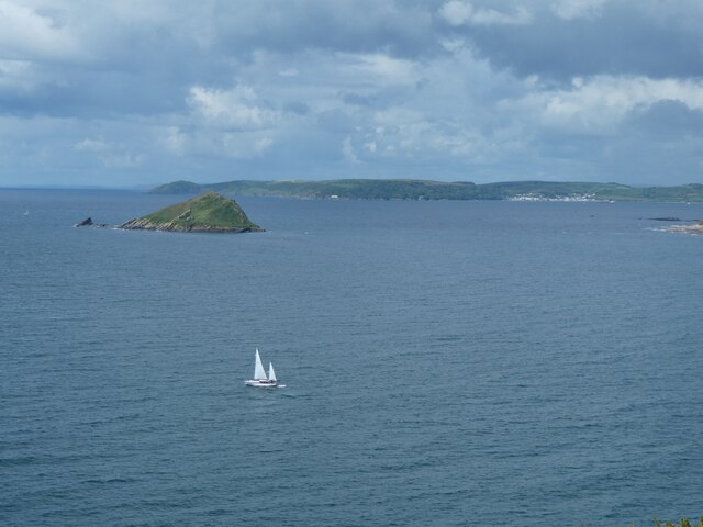
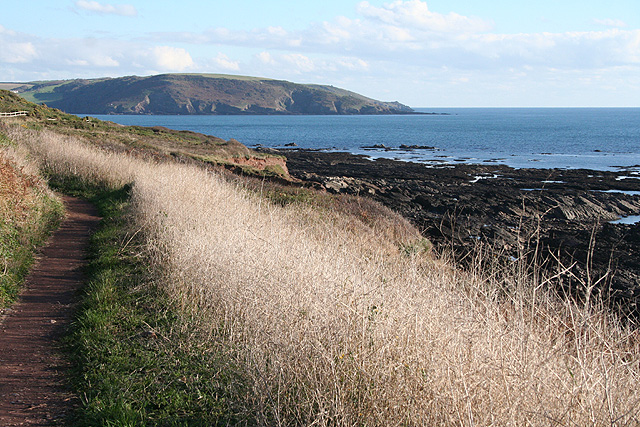
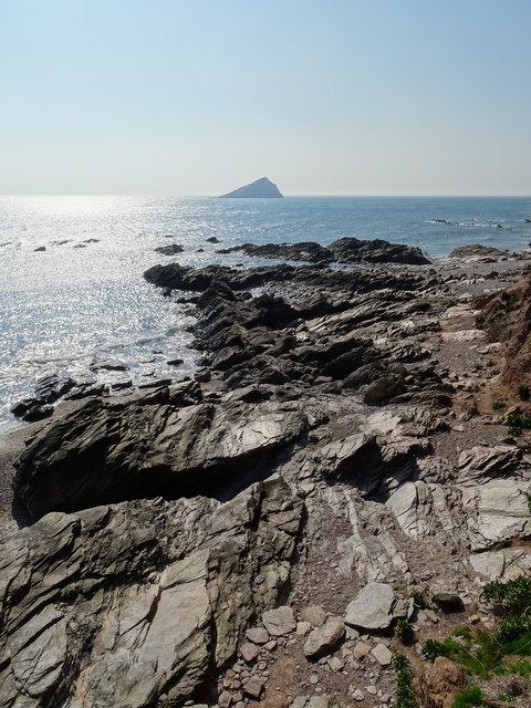
Blackstone Rocks is a small island located off the coast of Devon, England. Situated in the Bristol Channel, it is part of the North Devon coast. The island measures approximately 0.5 hectares and is made up of rugged cliffs and rocky outcrops.

The island gets its name from the distinctive black rocks that dominate its landscape. These rocks are made up of shale and slate, giving them their dark appearance. They have been shaped by years of erosion from the powerful waves of the channel, resulting in striking formations and jagged edges.

Blackstone Rocks is known for its rich biodiversity. The island provides a habitat for a variety of seabirds, such as gulls and cormorants, who nest on the cliffs. The surrounding waters are home to a diverse array of marine life, including seals, dolphins, and a range of fish species.

Access to the island is limited due to its remote location and treacherous waters. However, it is a popular spot for experienced kayakers and adventurous hikers who enjoy exploring its rocky terrain and observing the wildlife.

The island is also of historical significance, with evidence of human activity dating back to the Bronze Age. It has been used for fishing and farming in the past, and remnants of old structures can still be found on its surface.

Overall, Blackstone Rocks offers a unique and secluded natural environment, showcasing the raw beauty of the North Devon coast.

If you have any feedback on the listing, please let us know in the comments section below.

Blackstone Rocks Images

Images are sourced within 2km of 50.315354/-4.0827622 or Grid Reference SX5148. Thanks to Geograph Open Source API. All images are credited.

The rocky coast below The Warren
The Great Mew Stone Beyond the island is Rame Head
The Great Mew Stone
Beyond the island is Rame Head
Clouds gathering over South West Coast Path The South West Coast Path National Trail - 630 miles of superb coastal walking. From Minehead on the edge of the Exmoor National Park to the shores of Poole Harbour in Dorset. It is the longest of all Britain's National Trails.
Website: <span class="nowrap"><a title="http://www.southwestcoastpath.com/" rel="nofollow ugc noopener" href="http://www.southwestcoastpath.com/">Link</a><img style="margin-left:2px;" alt="External link" title="External link - shift click to open in new window" src="https://s1.geograph.org.uk/img/external.png" width="10" height="10"/></span>
Clouds gathering over South West Coast Path
The South West Coast Path National Trail - 630 miles of superb coastal walking. From Minehead on the edge of the Exmoor National Park to the shores of Poole Harbour in Dorset. It is the longest of all Britain's National Trails. Website: LinkExternal link
Estuary of River Yealm from South West Coast Path The South West Coast Path National Trail - 630 miles of superb coastal walking. From Minehead on the edge of the Exmoor National Park to the shores of Poole Harbour in Dorset. It is the longest of all Britain's National Trails.
Website: <span class="nowrap"><a title="http://www.southwestcoastpath.com/" rel="nofollow ugc noopener" href="http://www.southwestcoastpath.com/">Link</a><img style="margin-left:2px;" alt="External link" title="External link - shift click to open in new window" src="https://s1.geograph.org.uk/img/external.png" width="10" height="10"/></span>
Estuary of River Yealm from South West Coast Path
The South West Coast Path National Trail - 630 miles of superb coastal walking. From Minehead on the edge of the Exmoor National Park to the shores of Poole Harbour in Dorset. It is the longest of all Britain's National Trails. Website: LinkExternal link
Cellar Beach on River Yealm
Wembury: towards Wembury Bay On the South West Coast Path looking towards the land mass on the far side of the mouth of the river Yealm including Mouthstone Point, Noss Mayo
Wembury: towards Wembury Bay
On the South West Coast Path looking towards the land mass on the far side of the mouth of the river Yealm including Mouthstone Point, Noss Mayo
South West Coast Path South West Coast Path heading to Heybrook Bay
South West Coast Path
South West Coast Path heading to Heybrook Bay
South Hams : Coastal Scenery Looking across the coastline near Wembury Point with the Great Mewstone in view.
South Hams : Coastal Scenery
Looking across the coastline near Wembury Point with the Great Mewstone in view.
S.West Coast Path Heading towards Heybrook Bay.
S.West Coast Path
Heading towards Heybrook Bay.
South West Coast Path The South West Coast Path National Trail - 630 miles of superb coastal walking. From Minehead on the edge of the Exmoor National Park to the shores of Poole Harbour in Dorset. It is the longest of all Britain's National Trails.
Website: <span class="nowrap"><a title="http://www.southwestcoastpath.com/" rel="nofollow ugc noopener" href="http://www.southwestcoastpath.com/">Link</a><img style="margin-left:2px;" alt="External link" title="External link - shift click to open in new window" src="https://s1.geograph.org.uk/img/external.png" width="10" height="10"/></span>
South West Coast Path
The South West Coast Path National Trail - 630 miles of superb coastal walking. From Minehead on the edge of the Exmoor National Park to the shores of Poole Harbour in Dorset. It is the longest of all Britain's National Trails. Website: LinkExternal link
Coast at Wembury Point
South West Coast Path around Wembury Point
Mouth of the River Yealm There is a wave breaking over the bar at the mouth of the river; the approach to Newton Ferrers is close to the shore at Mouthstone Point
Mouth of the River Yealm
There is a wave breaking over the bar at the mouth of the river; the approach to Newton Ferrers is close to the shore at Mouthstone Point
Disused boat in garden
Wembury Bay
Wembury Bay
Wembury Point
Wembury Point
Great Mew Stone
Great Mew Stone
Great Mew Stone Great Mew Stone viewed from the coast path on Wembury Head.
Great Mew Stone
Great Mew Stone viewed from the coast path on Wembury Head.
Show me another place!

Blackstone Rocks is located at Grid Ref: SX5148 (Lat: 50.315354, Lng: -4.0827622)

Administrative County: Devon

District: South Hams

Police Authority: Devon and Cornwall

What 3 Words

///calendars.lump.young. Near Wembury, Devon

Related Wikis

Wembury

Wembury is a village on the south coast of Devon, England, very close to Plymouth Sound. Wembury is located south of Plymouth. Wembury is also the name...

Wembury Marine Centre

Wembury Marine Centre is situated in the small village of Wembury, near Plymouth. Run by Devon Wildlife Trust, it holds rockpool rambles throughout the...

River Yealm

The Yealm is a river in Devon in England that rises 430 m (1,410 ft) above sea level on the Stall Moor mires of south Dartmoor and travels 12 miles (19...

Langdon Court, Devon

Langdon Court is a former manor house, in Wembury, South Devon, England. It consists of a single courtyard mansion from 1693 and a walled formal garden...

Nearby Amenities

Located within 500m of 50.315354,-4.0827622
Barrier: kissing_gate
Foot: yes
Lat/Long: 50.3175808/-4.0825455
Entrance: yes
Lat/Long: 50.3178226/-4.0824997
Bench
Lat/Long: 50.3179006/-4.0798357
Bench
Lat/Long: 50.3181917/-4.0798357
Bench
Backrest: no
Lat/Long: 50.317224/-4.0781299
Barrier: kissing_gate
Lat/Long: 50.3185617/-4.0797298
Bench
Backrest: no
Lat/Long: 50.3180891/-4.0853546
Bench
Lat/Long: 50.3195713/-4.0813612
Covered: no
Leisure: picnic_table
Lat/Long: 50.3175023/-4.0829547
Covered: no
Leisure: picnic_table
Lat/Long: 50.3174263/-4.0829836
Covered: no
Leisure: picnic_table
Lat/Long: 50.3173991/-4.082869
Vending Machine
Vending: parking_tickets
Lat/Long: 50.3174553/-4.0831302
Waste Basket
Survey Date: 2022-01-02
Lat/Long: 50.3173265/-4.0787065
Defibrillator
Defibrillator Location: On outside wall of toilet building, facing footpath
Emergency: defibrillator
Indoor: no
Mapillary: 215660100405414
Survey Date: 2022-01-02
Lat/Long: 50.3177011/-4.0837734
Life Ring
Emergency: life_ring
Survey Date: 2022-01-02
Lat/Long: 50.3179807/-4.0843807
Bench
Backrest: no
Survey Date: 2022-01-02
Lat/Long: 50.317317/-4.0807509
Access: yes
Man Made: water_tap
Lat/Long: 50.3177039/-4.0837432
Bench
Mapillary: 341459197350608
Source Position: Mapillary 2021-06-13
Survey Date: 2022-01-29
Lat/Long: 50.3181422/-4.0850928
Bench
Survey Date: 2022-01-29
Lat/Long: 50.3181328/-4.0851673
Bench
Survey Date: 2022-01-29
Lat/Long: 50.3181279/-4.0852266
Fire Hydrant
Emergency: fire_hydrant
Fire Hydrant Diameter: 100
Fire Hydrant Position: lane
Fire Hydrant Type: underground
Survey Date: 2022-01-29
Lat/Long: 50.3195395/-4.0812843
The data included in this document is from www.openstreetmap.org. The data is made available under ODbL.

Have you been to Blackstone Rocks?

Leave your review of Blackstone Rocks below (or comments, questions and feedback).