A' Ghoil-Sgeir

Island in Sutherland

Scotland

A' Ghoil-Sgeir

View towards Eilean Hoan (Haven Island) From the A road to Durness.
View towards Eilean Hoan (Haven Island) Credit: Stanley Howe

A' Ghoil-Sgeir is a small uninhabited island located off the north coast of Scotland, in the county of Sutherland. The island is situated in the Pentland Firth, between Sutherland and Orkney. It is approximately 2.5 kilometers long and 1 kilometer wide, with a total area of around 80 hectares.

A' Ghoil-Sgeir is a rocky island, characterized by its rugged coastline and towering cliffs that reach up to 100 meters in height. The island is known for its diverse birdlife, with various seabird species such as guillemots, razorbills, and puffins nesting in the cliffs. These birds make the island a popular destination for birdwatchers and nature enthusiasts.

Despite its small size, A' Ghoil-Sgeir holds historical significance. It is believed that the island was used as a hunting ground by ancient inhabitants of the region, as evidenced by the remains of stone tools and hunting structures found on the island. The island's Gaelic name, A' Ghoil-Sgeir, translates to "the rocky island of the strait," which likely refers to its location in the Pentland Firth.

Access to A' Ghoil-Sgeir is limited, as there are no facilities or regular transportation services to the island. Visitors who wish to explore the island must arrange for private boat transport from the nearby mainland or Orkney. It is important to note that the island is strictly protected, and visitors are encouraged to respect the fragile ecosystems and wildlife present on A' Ghoil-Sgeir.

If you have any feedback on the listing, please let us know in the comments section below.

A' Ghoil-Sgeir Images

Images are sourced within 2km of 58.563156/-4.697127 or Grid Reference NC4367. Thanks to Geograph Open Source API. All images are credited.

View towards Eilean Hoan (Haven Island) From the A road to Durness.
View towards Eilean Hoan (Haven Island)
From the A road to Durness.
John Lennon Memorial Garden, Durness
Walking the dogs, Traigh Allt Chailgeag
Beach reflections, Traigh Allt Chailgeag
Contorted rock strata at Traigh Allt Chailgeag
Grand Canyon? Actually only about a metre high; a stream channel cutting through sand at the head of the cove.
Grand Canyon?
Actually only about a metre high; a stream channel cutting through sand at the head of the cove.
Castle by the sea Sand castle at Traigh Allt Chailgeag.
Castle by the sea
Sand castle at Traigh Allt Chailgeag.
Waterfall (Smoo Cave) The waterfall drops into the cave through a sink hole. Smoo Cave is located at the eastern edge of the village of Durness on Scotland's most northerly coastline. Well worth a visit.
Waterfall (Smoo Cave)
The waterfall drops into the cave through a sink hole. Smoo Cave is located at the eastern edge of the village of Durness on Scotland's most northerly coastline. Well worth a visit.
Coastal inlet The entrance of Smoo Cave is located at the end of a 600m long tidal gorge.
Coastal inlet
The entrance of Smoo Cave is located at the end of a 600m long tidal gorge.
Tràigh Allt Chàilgeag and Rubh' an Daimh With Whiten Head on the horizon.
Tràigh Allt Chàilgeag and Rubh' an Daimh
With Whiten Head on the horizon.
Looking out of Smoo Cave And down Geodha Smoo to the sea.
Looking out of Smoo Cave
And down Geodha Smoo to the sea.
A Common Gull (Larus canus) This Common Gull looks splendid in his summer livery. It resembles the Herring Gull in its general pattern but is smaller and has no red marking on its bill.
A Common Gull (Larus canus)
This Common Gull looks splendid in his summer livery. It resembles the Herring Gull in its general pattern but is smaller and has no red marking on its bill.
The rocky outcrop at Traigh Allt Chailgeag Situated near the mouth of Loch Eriboll the beauty of the beach here is striking and the sea is crystal clear. That island in the background is Eilean Hoan.
The rocky outcrop at Traigh Allt Chailgeag
Situated near the mouth of Loch Eriboll the beauty of the beach here is striking and the sea is crystal clear. That island in the background is Eilean Hoan.
Black-headed Gull (Chroicocephalus ridibundus) With its deep red bill, its deep red legs and its dark brown hood, this gull is easily recognised and is abundant by the shore as well as inland.
Black-headed Gull (Chroicocephalus ridibundus)
With its deep red bill, its deep red legs and its dark brown hood, this gull is easily recognised and is abundant by the shore as well as inland.
Tràigh Allt Chàilgeag - 1987 Tràigh Allt Chàilgeag seen from the A838 car park. Eilean Hoan visible in the distance.
Tràigh Allt Chàilgeag - 1987
Tràigh Allt Chàilgeag seen from the A838 car park. Eilean Hoan visible in the distance.
An almost deserted beach Tràigh Allt Chàilgeag.
An almost deserted beach
Tràigh Allt Chàilgeag.
Cottage by the A838 Overlooking Tràigh Allt Chàilgeag <a title="https://www.geograph.org.uk/photo/2513350" href="https://www.geograph.org.uk/photo/2513350">Link</a> .
Cottage by the A838
Overlooking Tràigh Allt Chàilgeag Link .
Tràigh Allt Chàilgeag The sandy beach is viewed from the road leading to Rispond Pier.
Tràigh Allt Chàilgeag
The sandy beach is viewed from the road leading to Rispond Pier.
Show me another place!

A' Ghoil-Sgeir is located at Grid Ref: NC4367 (Lat: 58.563156, Lng: -4.697127)

Unitary Authority: Highland

Police Authority: Highlands and Islands

What 3 Words

///charge.formless.comically. Near Oldshoremore, Highland

Nearby Locations

A' Ghoil-Sgeir An Cruachan

Related Wikis

Sangobeg

Sangobeg (Scottish Gaelic: Saingea Beag) is a remote coastal crofting township which overlooks Sangobeg Sands in Sutherland, Scottish Highlands in the...

Leirinmore

Leirinmore (Scottish Gaelic: An Leithrinn Mhòr) is a crofting township in the parish of Durness on the northern coastline of Scotland, in Sutherland, Scottish...

Eilean Hoan

Eilean Hoan is an island in Loch Eriboll in Sutherland on the north coast of Scotland. It is about 28 hectares (69 acres) in extent and the highest point...
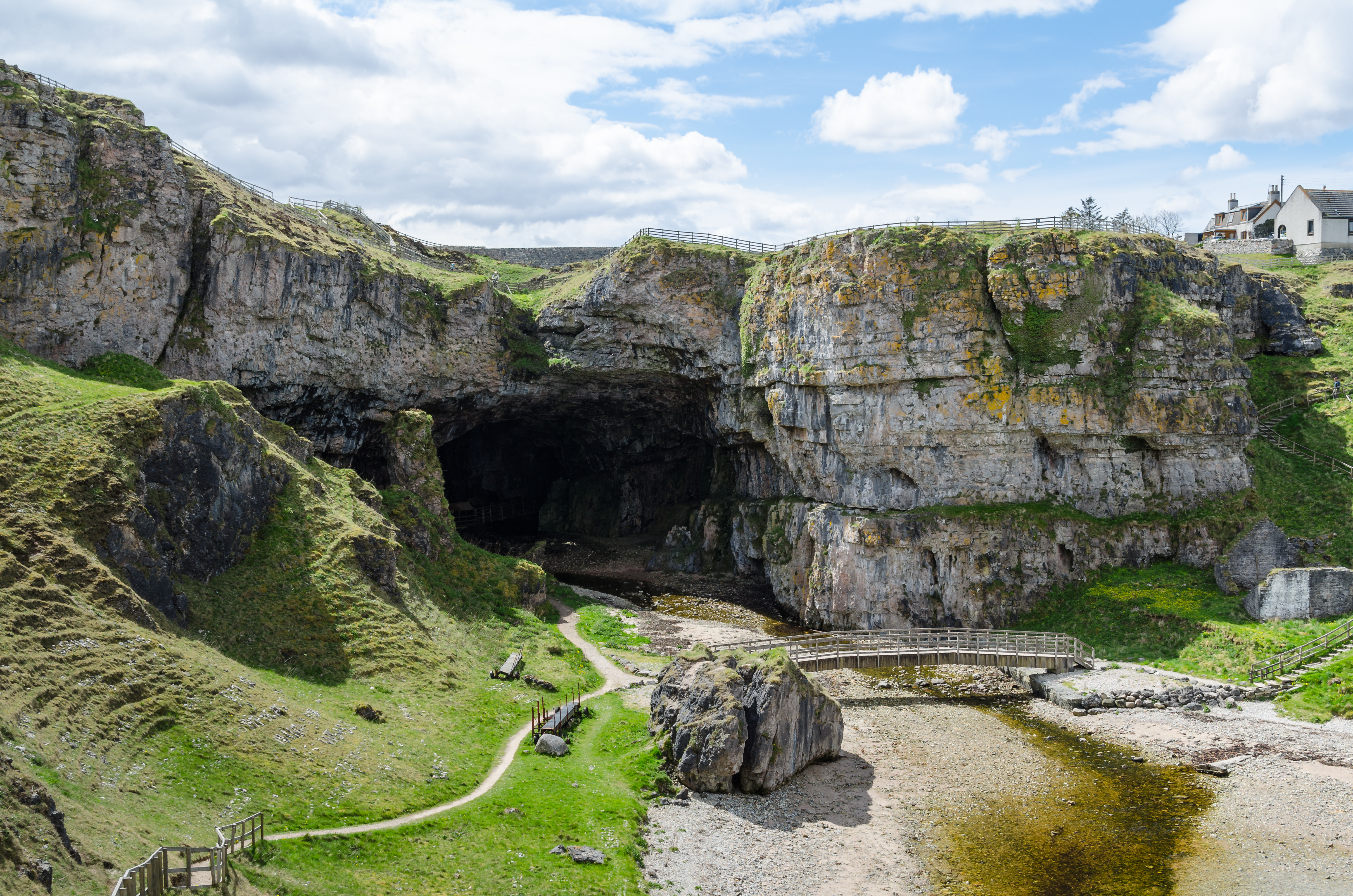
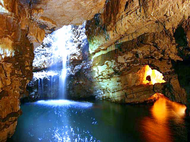
Smoo Cave

Smoo Cave is a large combined sea cave and freshwater cave in Durness in Sutherland, Highland, Scotland. The cave name is thought to originate from the...

Nearby Amenities

Located within 500m of 58.563156,-4.697127
Source: PGS
Lat/Long: 58.5631738/-4.6983385
Source: PGS
Lat/Long: 58.5638316/-4.6976467
Source: PGS
Lat/Long: 58.5639917/-4.6968902
Source: PGS
Lat/Long: 58.5631606/-4.6965822
Source: PGS
Lat/Long: 58.5629483/-4.6960385
Source: PGS
Lat/Long: 58.5626984/-4.6963024
Source: PGS
Lat/Long: 58.5622843/-4.6975373
Source: PGS
Lat/Long: 58.5627816/-4.697899
Source: PGS
Lat/Long: 58.5628448/-4.6986566
The data included in this document is from www.openstreetmap.org. The data is made available under ODbL.

Have you been to A' Ghoil-Sgeir?

Leave your review of A' Ghoil-Sgeir below (or comments, questions and feedback).