Careg Wylan

Island in Pembrokeshire

Wales

Careg Wylan

Low tide on Careg Yspar A wetsuit and a waterproof camera bag were needed to get to this location!
Low tide on Careg Yspar Credit: Dave Croker

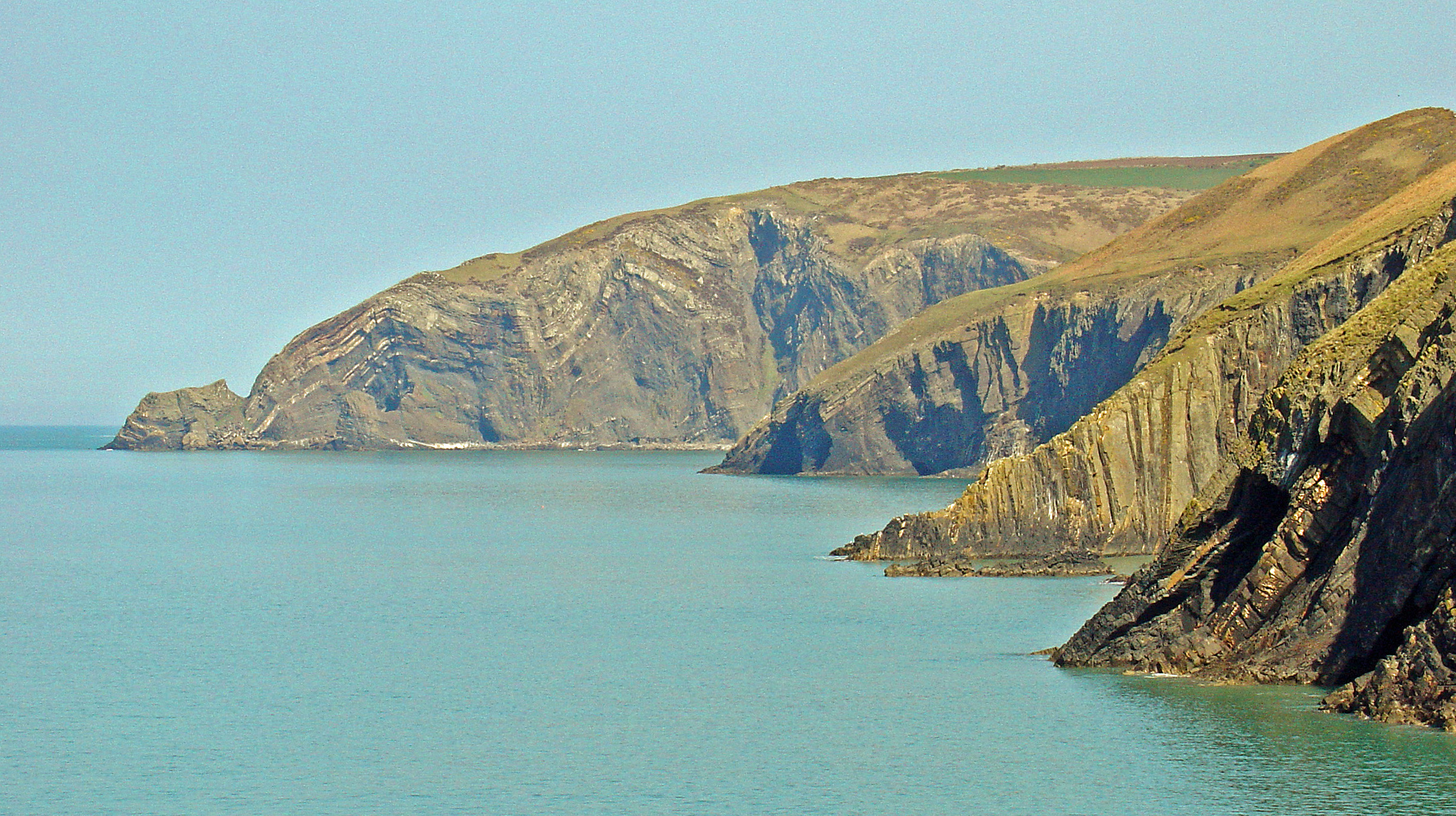
Careg Wylan, also known as Bird Rock, is a small island located off the coast of Pembrokeshire in Wales. It is situated near the beautiful St. Davids Head and is part of the St. Brides Bay area. The island is known for its stunning natural beauty and is a popular destination for birdwatching enthusiasts.

Careg Wylan is a rocky island that measures approximately 400 meters in length and 200 meters in width. It is home to a diverse range of bird species, including razorbills, guillemots, fulmars, and kittiwakes. The island's cliffs provide ideal nesting spots for these birds, making it an important breeding ground.

Access to Careg Wylan is restricted to protect the bird population, and visitors are not allowed to land on the island. However, it can be viewed from various viewpoints along the Pembrokeshire Coast Path, which runs adjacent to the island. The stunning coastal scenery and the sight of numerous seabirds soaring above the cliffs make for a memorable experience.

The island is also known for its rich marine life, with seals often spotted swimming in the surrounding waters. It is a designated Special Protection Area due to the importance of its bird population and is managed by the National Trust.

In summary, Careg Wylan is a picturesque island off the coast of Pembrokeshire, known for its stunning cliffs, diverse bird species, and rich marine life. It offers a unique opportunity to observe and appreciate nature in its purest form.

If you have any feedback on the listing, please let us know in the comments section below.

Careg Wylan Images

Images are sourced within 2km of 52.077465/-4.7665076 or Grid Reference SN1045. Thanks to Geograph Open Source API. All images are credited.

Low tide on Careg Yspar A wetsuit and a waterproof camera bag were needed to get to this location!
Low tide on Careg Yspar
A wetsuit and a waterproof camera bag were needed to get to this location!
Pembrokeshire Coast path Heading out to sea.
Pembrokeshire Coast path
Heading out to sea.
Coast line from above Bwn Bach
Looking into inlet east of Bwn Bach Ogof Ddu and Ogof Goch are two caves off this inlet.
Looking into inlet east of Bwn Bach
Ogof Ddu and Ogof Goch are two caves off this inlet.
Natural arch below the Pembrokeshire Coast Path Is this the one named Bwn Bach?
Natural arch below the Pembrokeshire Coast Path
Is this the one named Bwn Bach?
Careg Yspar This is the smaller section of Careg Yspar, the main body to the right is connected to the mainland.
Careg Yspar
This is the smaller section of Careg Yspar, the main body to the right is connected to the mainland.
Bwn Bach natural arch Light just about showing through from the west side of this natural arch, seen from the Pembrokeshire Coast Path.
Bwn Bach natural arch
Light just about showing through from the west side of this natural arch, seen from the Pembrokeshire Coast Path.
Carreg Yspar An essay in green and grey.
Carreg Yspar
An essay in green and grey.
Careg Yspar
Careg Yspar
The Pembrokeshire Coast Path near Ogof Goch
Bwn Bach Small natural arch at the bottom of a steep slope - the maps show this as Bwn Bach, but "bwa" is the Welsh word for "bow" so this might be a mistranscription at some point.
Bwn Bach
Small natural arch at the bottom of a steep slope - the maps show this as Bwn Bach, but "bwa" is the Welsh word for "bow" so this might be a mistranscription at some point.
Coastal Path at Ogof Goch Going round two collapsed caves, Ogof Ddu and Ogof Goch. 60m drop to the right
Coastal Path at Ogof Goch
Going round two collapsed caves, Ogof Ddu and Ogof Goch. 60m drop to the right
Stile and gate on the Wales Coast Path Tricky business making a fence to the right of the gate
Stile and gate on the Wales Coast Path
Tricky business making a fence to the right of the gate
Sheer drop by the Coast Path The view back after crossing the stile at <a href="https://www.geograph.org.uk/photo/6258314">SN0944 : Stile and gate on the Wales Coast Path</a>
Sheer drop by the Coast Path
The view back after crossing the stile at SN0944 : Stile and gate on the Wales Coast Path
View north from the Pembrokeshire Coast Path The rocky islet is Careg Ysbar, and Pen yr Afr is the headland on the horizon
View north from the Pembrokeshire Coast Path
The rocky islet is Careg Ysbar, and Pen yr Afr is the headland on the horizon
Between Ceibwr and Newport Sands A remote stretch of the Pembrokeshire Coast Path
Between Ceibwr and Newport Sands
A remote stretch of the Pembrokeshire Coast Path
Pembrokeshire/Wales Coast Path Heading along a lonely stretch towards Ceibwr Bay
Pembrokeshire/Wales Coast Path
Heading along a lonely stretch towards Ceibwr Bay
Careg Yspar along the Pembrokeshire coast
Show me another place!

Careg Wylan is located at Grid Ref: SN1045 (Lat: 52.077465, Lng: -4.7665076)

Unitary Authority: Pembrokeshire

Police Authority: Dyfed Powys

What 3 Words

///outraged.trump.budding. Near Nevern, Pembrokeshire

Related Wikis

Aberarth – Carreg Wylan

Aberarth – Carreg Wylan is a Site of Special Scientific Interest in Ceredigion, west Wales. It is a small coastal marine protected area with a reported...

Moylgrove

Moylgrove (Welsh: Trewyddel), also spelled Moylegrove, is a village and parish in north Pembrokeshire, Wales, about 4 miles (6.4 km) from Cardigan, in...

Ceibwr Bay

Ceibwr Bay (Welsh: Bae Ceibwr) is a bay opening into the Irish Sea in Pembrokeshire, west Wales. It is about 7 km west of Cardigan, and 3 km south of the...

St Dogmells Rural District

St Dogmells was a rural district in the administrative county of Pembrokeshire, Wales from 1894 to 1934. == Formation == The district was created by the...

Nearby Amenities

Located within 500m of 52.077465,-4.7665076
Bae Ceibwr Bay
Name Cy: Bae Ceibwr
Name En: Ceibwr Bay
Natural: bay
Url: https://www.visitpembrokeshire.com/explore-pembrokeshire/beaches/ceibwr-bay
Wikidata: Q5057357
Wikipedia: en:Ceibwr Bay
Lat/Long: 52.0786589/-4.7611296
Leisure: picnic_table
Lat/Long: 52.074679/-4.7635903
Ynys Fâch
Image: https://www.geograph.org.uk/photo/6097647
Natural: cape
Lat/Long: 52.0792384/-4.761119
Parking
Lat/Long: 52.0767493/-4.7596826
The data included in this document is from www.openstreetmap.org. The data is made available under ODbL.

Have you been to Careg Wylan?

Leave your review of Careg Wylan below (or comments, questions and feedback).