Horse Island

Island in Cromartyshire

Scotland

Horse Island

Beach on Horse Sound At Badenscallie.
Beach on Horse Sound Credit: Dave Fergusson

Horse Island is a small island located off the coast of Cromartyshire, in the northern part of Scotland. It is part of the Inner Hebrides archipelago and is situated in the North Sea. The island covers an area of approximately 1.5 square kilometers and has a population of only a few individuals.

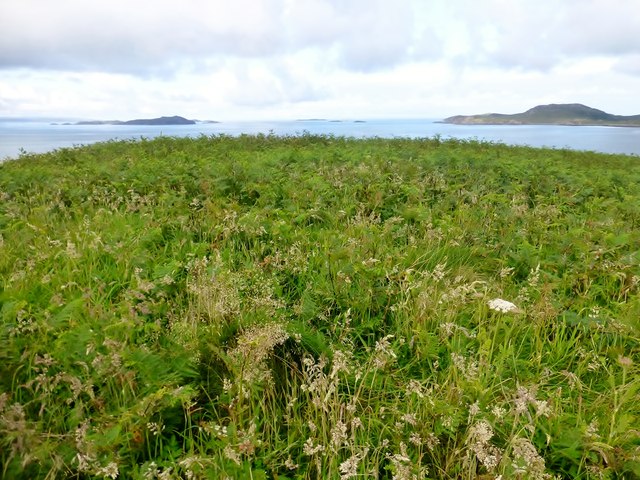
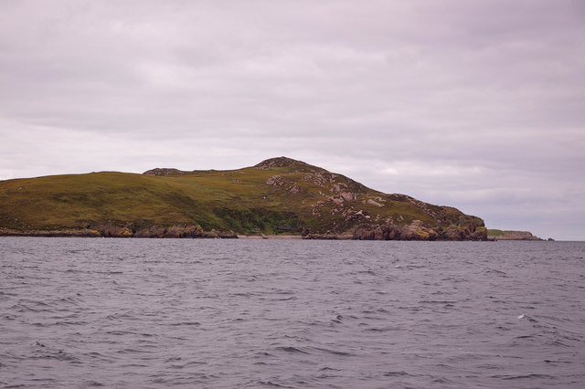
Horse Island is known for its stunning natural beauty and rugged landscape. The island is largely uninhabited, with only a few scattered cottages and a lighthouse. Its rocky coastline is lined with cliffs, providing breathtaking views of the surrounding sea and distant mountains.

The island's name is derived from the Gaelic word "Eilean nam Each," which translates to "Island of the Horses." It is believed that the name originates from the time when the island was used as a grazing ground for horses. Today, however, there are no horses inhabiting the island.

Horse Island is a popular destination for nature enthusiasts and birdwatchers. Its diverse ecosystem supports a variety of bird species, including puffins, gannets, and guillemots. The island is also home to seals and other marine life, making it an ideal spot for wildlife observation.

Access to Horse Island is limited, with no regular ferry service. Visitors can reach the island by private boat or by booking a guided tour from nearby Cromartyshire. It is important to note that the island has no facilities or amenities, so visitors are advised to come prepared with essentials and to respect the fragile environment.

If you have any feedback on the listing, please let us know in the comments section below.

Horse Island Images

Images are sourced within 2km of 57.986047/-5.3458877 or Grid Reference NC0204. Thanks to Geograph Open Source API. All images are credited.

Beach on Horse Sound At Badenscallie.
Beach on Horse Sound
At Badenscallie.
Beach on Horse Sound Looking towards Tannara Mòr.
Beach on Horse Sound
Looking towards Tannara Mòr.
Sunset Summer Isles Taken on beach near to Achininver Youth Hostel, August 2011.
Sunset Summer Isles
Taken on beach near to Achininver Youth Hostel, August 2011.
Achiltibuie and Polglass by Loch Broom Hanging valley and truncated spur to left of picture.  Loch Broom is a drowned glacial trough.  The linear settlements of Achiltibuie and Polglass are sited on a raised beach.
Achiltibuie and Polglass by Loch Broom
Hanging valley and truncated spur to left of picture. Loch Broom is a drowned glacial trough. The linear settlements of Achiltibuie and Polglass are sited on a raised beach.
Horse Island Summit After a trick RIB to rock landing we bagged the P60 top of Horse Island.  This is Andrew Tibbetts standing on the summit cairn.
Horse Island Summit
After a trick RIB to rock landing we bagged the P60 top of Horse Island. This is Andrew Tibbetts standing on the summit cairn.
Horse Island Preparing To Leave Climbing down through the deep moorland vegetation to be collected by our RIB so that we can leave Horse Island.
Horse Island Preparing To Leave
Climbing down through the deep moorland vegetation to be collected by our RIB so that we can leave Horse Island.
Meall nan Gabhar Meall nan Gabhar, also known as Goat Island is a tidal island at times connected to Horse Island at low tide for a time.
Meall nan Gabhar
Meall nan Gabhar, also known as Goat Island is a tidal island at times connected to Horse Island at low tide for a time.
Climbing Down Towards Meall nan Gabhar Climbing down from Horse Island to inspect the area between Horse island and Meall nan Gabhar which can be connected at low tide.
Climbing Down Towards Meall nan Gabhar
Climbing down from Horse Island to inspect the area between Horse island and Meall nan Gabhar which can be connected at low tide.
Landing On Horse Island Horse Island is not the easiest island to land on as this photo shows.
Landing On Horse Island
Horse Island is not the easiest island to land on as this photo shows.
Horse Island, at the mouth of Loch Broom Separated by Horse Sound on the right from Achiltibuie and the Coigach Peninsula.
Horse Island, at the mouth of Loch Broom
Separated by Horse Sound on the right from Achiltibuie and the Coigach Peninsula.
Iolla Mhòr A small skerry, with Horse Island behind (and the houses of Achiltibuie visible in the far distance, right).
Iolla Mhòr
A small skerry, with Horse Island behind (and the houses of Achiltibuie visible in the far distance, right).
Small rock off the southwestern tip of Horse Island Another jaggy volcanic rock.
Small rock off the southwestern tip of Horse Island
Another jaggy volcanic rock.
Horse Island The south-west coast of this small island.
Horse Island
The south-west coast of this small island.
Western extremity of Meall nan Gabhar This rocky lump is well-named as suitable only for goats.
Western extremity of Meall nan Gabhar
This rocky lump is well-named as suitable only for goats.
Meall nan Gabhar Alternatively, Goat Island, just to the north of Horse Island.
Meall nan Gabhar
Alternatively, Goat Island, just to the north of Horse Island.
An old rockfall, Horse Island Big boulders have fallen from the cliffs on the S end of the island. Seen from the MV 'Summer Queen' trip from Ullapool.
An old rockfall, Horse Island
Big boulders have fallen from the cliffs on the S end of the island. Seen from the MV 'Summer Queen' trip from Ullapool.
Meall nan Gabhar Landed NE corner of Horse Island, then easy low-tide crossing to Goat Island. Little easy scramble up a gully then grassy ascent. 
Name: Meall nan Gabhar
Hill number: 10082
Height: 51m / 167ft
Parent (Ma/M): none
Section: 16F: Lochinver to Ullapool
County/UA: Highland (UA)
Island: Mono Tump island (t)
Maritime Area: Gruinard & The Summer Isles
Class: Tump (0-99m), SIB
Grid ref: NC 02225 05486
Summit feature: no feature: grass and bracken
Drop: 50m
Col: 1m  NC022053
Meall nan Gabhar
Landed NE corner of Horse Island, then easy low-tide crossing to Goat Island. Little easy scramble up a gully then grassy ascent. Name: Meall nan Gabhar Hill number: 10082 Height: 51m / 167ft Parent (Ma/M): none Section: 16F: Lochinver to Ullapool County/UA: Highland (UA) Island: Mono Tump island (t) Maritime Area: Gruinard & The Summer Isles Class: Tump (0-99m), SIB Grid ref: NC 02225 05486 Summit feature: no feature: grass and bracken Drop: 50m Col: 1m NC022053
Meall nan Gabhar Looking across Horse Sound from Badenscaillie.  The N tip of Horse Island is on the left.
Meall nan Gabhar
Looking across Horse Sound from Badenscaillie. The N tip of Horse Island is on the left.
Show me another place!

Horse Island is located at Grid Ref: NC0204 (Lat: 57.986047, Lng: -5.3458877)

Unitary Authority: Highland

Police Authority: Highlands and Islands

What 3 Words

///maternal.storming.shifts. Near Ullapool, Highland

Related Wikis

Horse Island, Summer Isles

Horse Island (Scottish Gaelic: Eilean nan Each) is an uninhabited island in the Summer Isles, in the north west of Scotland. Once inhabited, the island...

Achduart

Achduart (Gaelic: Achadh Dhubhaird) is a coastal hamlet in Coigach, Wester Ross in northwestern Scotland, now within the Highland council area. It is situated...

Polglass

Polglass (Scottish Gaelic: Am Poll Glas) is a long crofting township, lying on the north shore of the sea loch, Loch Broom in Ullapool Ross-shire, Scottish...

Achiltibuie

Achiltibuie (; Scottish Gaelic: Achd Ille Bhuidhe or Field of the yellow-haired boy) is a long linear village in Ross and Cromarty, Highland, on the Coigach...

Coigach

Coigach (Scottish Gaelic: A' Chòigeach) is a peninsula north of Ullapool, in Wester Ross in the Northwest Highlands of Scotland. The area consists of a...

Badentarbat Bay

Badentarbat Bay, or Badentarbet Bay, is a bay in northern Scotland. The village of Achiltibuie overlooks it. Marian Leven painted scenes of the bay....

Tanera Mòr

Tanera Mòr (Scottish Gaelic: Tannara Mòr) is a sporadically inhabited island in Loch Broom in the Inner Hebrides of Scotland, the largest of the Summer...

Eilean Dubh, Summer Isles

Eilean Dubh is an uninhabited island in Loch Broom, one of the smaller Summer Isles. It lies about two miles south of Tanera Beag and has probably not...

Nearby Amenities

Located within 500m of 57.986047,-5.3458877
Created By: almien_coastlines
Source: PGS
Lat/Long: 57.983569/-5.351595
Created By: almien_coastlines
Source: PGS
Lat/Long: 57.983834/-5.35113
Created By: almien_coastlines
Source: PGS
Lat/Long: 57.98461/-5.350699
Created By: almien_coastlines
Source: PGS
Lat/Long: 57.984874/-5.350234
Created By: almien_coastlines
Source: PGS
Lat/Long: 57.985906/-5.34982
Created By: almien_coastlines
Source: PGS
Lat/Long: 57.986171/-5.349355
Created By: almien_coastlines
Source: PGS
Lat/Long: 57.986691/-5.348907
Created By: almien_coastlines
Source: PGS
Lat/Long: 57.987979/-5.348509
Created By: almien_coastlines
Source: PGS
Lat/Long: 57.988747/-5.348559
Created By: almien_coastlines
Source: PGS
Lat/Long: 57.989002/-5.348576
Created By: almien_coastlines
Source: PGS
Lat/Long: 57.989258/-5.348593
Created By: almien_coastlines
Source: PGS
Lat/Long: 57.989514/-5.348609
Created By: almien_coastlines
Source: PGS
Lat/Long: 57.989779/-5.348145
Created By: almien_coastlines
Source: PGS
Lat/Long: 57.990039/-5.34792
Created By: almien_coastlines
Source: PGS
Lat/Long: 57.990012/-5.349365
Created By: almien_coastlines
Source: PGS
Lat/Long: 57.989285/-5.340155
Created By: almien_coastlines
Source: PGS
Lat/Long: 57.989153/-5.340389
Created By: almien_coastlines
Source: PGS
Lat/Long: 57.988377/-5.34082
Created By: almien_coastlines
Source: PGS
Lat/Long: 57.987098/-5.340737
Created By: almien_coastlines
Source: PGS
Lat/Long: 57.986084/-5.340188
Created By: almien_coastlines
Source: PGS
Lat/Long: 57.985577/-5.339913
Created By: almien_coastlines
Source: PGS
Lat/Long: 57.985595/-5.33895
Created By: almien_coastlines
Source: PGS
Lat/Long: 57.984827/-5.3389
Created By: almien_coastlines
Source: PGS
Lat/Long: 57.98481/-5.339863
Created By: almien_coastlines
Source: PGS
Lat/Long: 57.984298/-5.33983
Created By: almien_coastlines
Source: PGS
Lat/Long: 57.984417/-5.34032
Created By: almien_coastlines
Source: PGS
Lat/Long: 57.984408/-5.340801
Created By: almien_coastlines
Source: PGS
Lat/Long: 57.984276/-5.341035
Created By: almien_coastlines
Source: PGS
Lat/Long: 57.984143/-5.341266
Created By: almien_coastlines
Source: PGS
Lat/Long: 57.984011/-5.341499
Created By: almien_coastlines
Source: PGS
Lat/Long: 57.98324/-5.341689
Created By: almien_coastlines
Source: PGS
Lat/Long: 57.983093/-5.342644
Created By: almien_coastlines
Source: PGS
Lat/Long: 57.982961/-5.342877
Created By: almien_coastlines
Source: PGS
Lat/Long: 57.98219/-5.343067
Created By: almien_coastlines
Source: PGS
Lat/Long: 57.982172/-5.34403
The data included in this document is from www.openstreetmap.org. The data is made available under ODbL.

Have you been to Horse Island?

Leave your review of Horse Island below (or comments, questions and feedback).